Location: 15 km Northeast of Kardzhali Map
Open: 7:30am- 8pm May- Oct
Official site
Perperikon Archeological Site is an ancient
settlement located 15 km northeast of Kardzhali in the Western
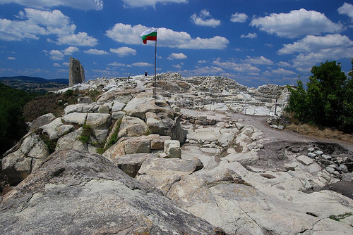
Rhodopes. Perperikon Archeological Site is situated on a 470 m
high rock above surrounding lands. It was inhabited by humans
since at least 5000 BC. Apparently it held both religious and
strategic importance. Over a centuries mountain was turned into
largest megalith structure in the Balkans intended to
commemorate god Sabazios (local version of Greek Dionysus).
Local legend also claim that Perperikon Archeological Site is
the site of Orpheus' burial place.
Several ancient
historians claim that priests that lived in Perperikon could
predict future for those who ventured this far from the advanced
Mediterranean basin. Greek historian Herodotus stated that
Persian king Xerxes visited the Perperikon mountain and talked
to the oracle about his future war with the Greeks. The
prediction turned out either wrong or Xerxes didn't listen to
their advices.
Suetonius Tranquillus in his infamous
"The Twelfth Caesars" claimed that father of Octavian Augustus
was told by the local oracles that his son will rule the whole
Roman Empire. Alexander the Great supposedly also visited
Perperikon during his campaign in the South Bulgaria. Legend
claims that his predictions of a huge empire stretching all the
way to India came true.
During Roman times a large
multi- story palace was constructed in Perperikon.
Fortifications were rebuilt yet again. According to early
Christian manuscripts Nicetas, Bishop of Remesiana (366-414)
lived here and created a Thracian alphabet so that local tribes
could read the Bible and pray in their native language. During
medieval times strategic location of Perperikon changed hands
between Bulgarian Kingdom and Byzantine Empire several times. It
was during this period the site got its name from perpera in
Bulgarian (or "hyperpyron" in Greek), a Byzantine gold coins
that were left here when Bulgarian captured the fortress. It is
also the reason why among Byzantines the site became known as
Hyperpyrakion. Perperikon was considered and important citadel
in political games as well as a seat of a local archbishop.
Location
The fortress - rock town Perperek is
located 15 km northeast of today's town of Kardzhali. It occupies
the highest peak (up to 735 m) above the valley, 10 km long and 3-4
km wide (approx. 300-370 m), through which flows the Perperek River,
a left tributary of the Arda River - Studen Kladenets Dam. The rock
town of Perperek, surrounded on three sides by the river, is located
6 km west of the village of Perperek, 2 km south of the village of
Gorna Krepost and 4 km east of the village of Stremtsi. Its area is
about 12,000 square meters. The megalithic complex, the largest on
the Balkan Peninsula, has an area of 5,000 square meters. The
sanctuary of the Thracians is located at 470 meters above sea level.
Perperek is one of the hundred national tourist sites in
Bulgaria.
Name
One of the earliest mentions of the
Perperek fortress in a medieval chronicle is in the second half of
the 13th century. According to the research of Prof. Petar
Mutafchiev, "...... in the patriarchal charter from 1339 under the
Metropolitan of Plovdiv the episcopate of I-perperak-ion is also
noted. Fortress of the same name (Perperak-ion, abbreviated from ...
I- perperak-ion) "is mentioned in the middle of the XIII century
during the war between Michael II Assen and Theodore II Lascaris
(George the Acropolis, 108.18, around 1254). It was located in the
Rhodopes and its name today (January 1930) is preserved in the name
Perperekdere, which bears a left tributary of the Arda, south of
Haskovo. The medieval fortress rose on a height, on the right bank
of Perperek ... ".
Bulgarian thracologists flatly refuse to
call the site "Perperikon" because it is the name given during
excavations from the XX-XXI century, without any support in previous
years, centuries and millennia. In fact, Perperek is the authentic
ancient Thracian name of the site and according to Prof. Alexander
Fol is its only possible name.
Perperek is also a male
Thracian name found in Homer. Prof. Fol reminds in his lecture that
the name of all Thrace is Perke, one of the names meaning "rock",
which is preserved in names such as Perperek, Persenk, Perin (in
dialect, today Pirin), and Perister - the mountain near the town of
Bitola (in present-day Northern Macedonia).
According to
Nikolay Ovcharov, the name of the place is connected with the gold
coins perpera, also known as gold coins in medieval Bulgaria.
According to other authors, the name of the gold coin perpera is
associated with the money tax perpera.
Detection
Perperek
(Perperak) has been the subject of research by Bulgarian historical
science since 1931, when the future Prof. Petar Mutafchiev included
it in his study "Towards the Church-Historical Geography of the
Plovdiv Region". Perperek (Perperak) has been known to the Bulgarian
archeological science since 1932, when the future Prof. Ivan Velkov
described it, and so the site entered into scientific circulation.
In 1938 Perperek together with other famous Bulgarian fortresses
became part of the curriculum of Bulgarian schools. Prof. Vasil
Zlatarski included in the general examination of the fortresses in
the Rhodopes and Perperek (Perperak) according to the well-known
medieval Greek sources in "History of the Bulgarian State", Volume
III (1940, posthumously).
Description and features
In the
nine-volume History of Bulgaria - Volume 3: Second Bulgarian State
the authors of the texts (Assoc. Prof. Borislav Primov, Ph.D.,
Strashimir Lishev, Ph.D., Prof. Petar Petrov, Assoc. Prof. Sonya
Georgieva, Assoc. Vasil Gyuzelev, Assoc. Prof. Lyubomir Yonchev,
Lilia Radkova) and on the maps (Assoc. Prof. Petar Koledarov), as
well as the 14-member editorial staff chaired by Prof. Dimitar
Kosev, express evidence from the scientific community in Bulgaria
and beyond its borders is a fact both for the name Perperek and for
the location of the fortress Perperek.
The rocky peak on
which Perperek was built was called by the part of the local
population "Jin Tepesi" (Turkish) - "The top of the deities". The
ridge is made of zeolitized rhyodacite pyroclastic flow of the
Beliplast complex. Characteristic of these rocks is that they are
softer and more susceptible to climatic conditions (weathering,
water erosion due to heavy rains and moisture), as well as easier to
handle by humans.
The first archeological research of
Perperek was conducted in the late 1960s and early 1970s by a team
of the Bulgarian Academy of Sciences under the scientific
supervision of Prof. Dr. Stamen Mihailov.
The Perperek rock sanctuary is a mountain massif
in which every inch of the rock surface has been worked by human
hands. At the very top are located: a pool with significant
dimensions for the location, namely - 12 m x 8 m x 6 m, rock
thrones, spacious, rock-cut rooms and benches. The so-called A
"sacred path" that leads to the so-called "Large temple", a room
with approximate dimensions - 100 m x10 - 12 m and digging into the
rocky bosom of the mountain, ranging from 3 m to 4.5 m. The interior
is designed on three levels. In the easternmost part of the temple
is carved a figure of a lion, standing on all fours. A significant
amount of Late Eneolithic pottery has been found in the area of
the old dirt ramps - a fact showing that the sanctuary was founded
and functioned during the second half of the Eneolithic. In the
central part of the fortress was discovered a late antique Christian
church, one-nave with two porches.
History
A sanctuary was
built on the hill during the Late Bronze and Early Iron Ages. One of
the archaeologists who worked on this site, Nikolai Ovcharov,
insists that this is the sanctuary dedicated to the god Dionysus of
the Thracian tribe Satri (whose priestly family were the Bessi),
which is mentioned many times in ancient Greek written sources.
(Macrobius reports that: "I learn that in Thrace the sun and Liber
are considered the same god. The Thracians call him Sebadius, as
Alexander Polychistor writes, and to this god on the hill Zilmisios
is dedicated a temple in the form of a rotunda, whose roof in the
middle is open "). The sanctuary has been sought after for a
century. It, along with that of Apollo at Delphi, are the two most
significant oracles in antiquity. According to ancient legends, in
the oracles, wine-fire rites were performed on a special altar, and
according to the height of the flames, the power of divination was
judged.
N. Ovcharov claims that the sanctuary of Dionysus
belongs to Perperek, referring to finds and ancient sources.
Euripides in his tragedy Hekaba (424 BC) writes, “surprised that“…
some say that Dionysius-Oracle is in the Pangaion (Kushnitsa)
mountain, while others say that he is in Hemus ( Stara Planina).
”According to the works of later Roman historians, however,
Dionysius the Oracle in the Rhodopes is the most important
sanctuary. One of the main pieces of information referring to the
Rhodope sanctuary of Dionysus is that of the Roman historian
Suetonius Tranquillus. In his work, The Twelve Caesars, he describes
the prophecy given to the father of the first Roman emperor,
Octavian Augustus, that his son would be master of the whole world,
as indicated by the flames burning high at the altar. In the same
sanctuary of Alexander the Great, it is predicted that he will
conquer the known world from Egypt to India. In "the description of
Xerxes I's campaign against the Greeks in 480 BC. Herodotus also
mentions the oracle of Dionysus, "" which was located on a high peak
in the mountains. The prophecies in the sanctuary were dealt with by
the demons; the priestess gave predictions just as in the Delphic
oracle, there is nothing different. "
Leading thracologists,
including Prof. Valeria Fol, strongly disagree with Ovcharov's
assumption. According to Prof. Valeria Fol, Perperek is not the
sanctuary of Dionysius, although the site has a long life as a
sanctuary, as a city and church center. She emphasizes that at the
top of Persenk are the ruins of a large sanctuary, along which
passes an ancient sacred road and there are extremely well-preserved
very early Thracian fortresses. According to Prof. Valeria Fol, this
route was one of the most actively used in ancient times road
arteries in the Rhodopes and it can cross the whole mountain. She
emphasizes that the great sanctuary of Dionysus should be sought
along the route of this road below Persenk.
N. Ovcharov
expresses the opinion that this place was also the episcopal city,
where in the early 5th century Nikita Remesiansky baptized the Bessi
and gave them the Thracian alphabet and worship in the Thracian
language. The temple of the ancient city is probably dedicated to
the Thracian world god Zagreus. Macrobius (400) reports an
oval-shaped sanctuary.
The sacred millennial city was destroyed by the
Ottoman Turks in 1362 and its inhabitants were abducted into
slavery. After a few decades, the place is completely deserted. In
1837, Dr. Ami Bue included in the collection of routes in European
Turkey, part of Thrace, Chapter XI: "Rhodopes or Despoto-Dag and
their roads" brief data on Perperekdere. At the end of the 19th
century, Konstantin Irecek reported on the medieval fortress of
Hyperperakion, although he did not personally visit the area. An
interesting point in his description is the fact that among the
predominant Turkish toponyms the only survivor in Turkish is the
hydronym Perperek-dere, the name of the river / gorge that formed
the beautiful valley above which rises the rock-cut fortress.
Excavations of the site began in 2000 and were accompanied by
many controversial points about the scientifically inadmissible
archaeological work and the prevailing approach to overestimating
the presumed but unproven profit in presenting the results of
archaeological research, conservation, preservation and exposure of
object.
In 2006, a team from Around the World and in Bulgaria
found eyewitnesses who claimed the tombs had been looted in the
1990s.