Location: Grenaavej 12, 8410 Rønde, Central Jutland Map
Area: 180 sq km (69 sq mi)
Official site
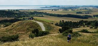
Mols Bjerge National Park, Denmark's second national park, is a stunning expanse of rolling hills, ancient forests, and coastal landscapes nestled in the heart of the Djursland peninsula in Central Jutland. Spanning approximately 180 square kilometers (69 square miles), it encompasses the southern parts of the Djursland headland, bounded by the Kattegat Sea to the east, the Kaløskovene forests to the west, and a series of glacially carved inlets, coves, and plains to the south. The park includes the charming coastal town of Ebeltoft and several villages, blending wild natural beauty with human settlements and summer house areas. Established under Executive Order 789 on August 21, 2009, and officially inaugurated by Queen Margrethe II on August 29 of the same year, the park was announced by Environment Minister Troels Lund Poulsen on January 17, 2008, to protect and unify fragmented natural and cultural sites in the region. Unlike traditional fenced reserves, the park has no physical boundaries—its edges are marked by a symbolic green line on maps—allowing seamless integration with surrounding farmlands and communities. Open year-round with no entrance fee, it welcomes visitors to immerse themselves in a landscape shaped by the Ice Age, where ice and water have sculpted dramatic peaks, deep glacial pits, and diverse habitats over millions of years.
Best Time to Visit
Late spring to early autumn (May–September):
Mild weather (15–22°C/59–72°F), longer days, and full access to
activities. Summers can be warm but occasionally rainy.
Shoulder
seasons (spring/early autumn): Fewer crowds, beautiful light, and good
hiking conditions. Late spring/early autumn often balances weather and
quietness.
Winter/autumn: Quieter with fewer people (you may have
trails almost to yourself), potential for atmospheric colors/frost, but
colder, shorter days, and some facilities closed. Possible for hardy
hikers.
The park is open year-round with no entrance fee.
How
to Get There
By car (easiest): Drive from Aarhus (35–45 minutes to
Rønde or Ebeltoft). Plenty of parking at trailheads (e.g., Kalø
Slotsruin, Strandkær, Agri Bavnehøj, Trehøje).
By public transport:
Bus 123 from Aarhus via Rønde to Ebeltoft stops near several trailheads
(e.g., Kalø Slotsruin, Femmøller). Feasible for day trips or base in
Ebeltoft.
Base towns: Ebeltoft (charming, colorful half-timbered town
with harbor, good facilities) or Rønde. Aarhus makes a convenient
larger-city base for day trips.
Top Attractions and Activities
Hiking: The star activity. The flagship Mols Bjerge Trail (Mols
Bjerge-stien) is an 80 km internationally certified Leading Quality
Trail divided into 4 stages (~20 km each). It passes diverse landscapes,
viewpoints, and historic sites.
Shorter options: 35+ marked trails
(1–14 km). Popular ones include:
Kalø Castle Ruins loop (via
Hestehave forest and Ringelmose) — ~11–12 km, historic + scenic.
Trehøje (three hilltops at 127m) for panoramic views.
Agri Bavnehøj
and mountain stages for hills and vistas.
Jernhatten for coastal
views.
Wildlife: Spot grazing wild horses, birds (use bird
towers), and marine life.
Water activities: Beaches for swimming,
snorkeling, sailing, seal safaris, fishing.
Other: Cycling/MTB
trails, horse riding, guided tours (National Park Bus sightseeing),
visitor centers with info/museums.
Kalø Slotsruin: Iconic medieval
castle ruins on a peninsula with great views.
Practical Visiting
Tips
Maps & Navigation: Download the official “Nationalpark Mols
Bjerge” app for interactive maps, trails, parking, and overnight spots.
AllTrails is excellent for user routes. Physical maps available at
tourist offices/visitor centers.
What to Bring:
Sturdy hiking
boots/shoes (terrain can be uneven/hilly).
Weather-appropriate layers
(wind/rain common), rain jacket.
Water, lunch/snacks (few facilities
on trails, especially off-season).
Power bank, binoculars, headlamp
if late.
Reusable items for eco-friendliness.
Code of Conduct:
Follow “Leave No Trace” — stick to paths, respect wildlife/livestock, no
fires except designated spots, clean up after dogs. Check rules for
biking/horses.
Facilities: Toilets at parking/trailheads and visitor
centers (e.g., Øvre Strandkær/Karlsladen). Some heated shelters for
breaks.
Safety: Trails are generally well-marked and safe. Watch for
weather changes, ticks in summer, and slippery spots near water/ruins.
Overnight Options
Camping/shelters: Free or low-cost primitive
shelters, tent sites (book some via Naturstyrelsen). Several options
in/near the park.
Cabins/campsites: Mols Bjerge Camping or similar
with facilities.
Towns: Hotels, B&Bs, or Airbnbs in Ebeltoft
(recommended base), Rønde, or villages. Luxury or cozy options
available.
Multi-day trail hikers can use luggage transfer services
for comfort.
Day Trip vs. Multi-Day
Day trip: Easy from Aarhus
(focus on Kalø + one hike) or base in Ebeltoft.
2–4+ days: Ideal for
the full trail, multiple sections, relaxation in towns, and activities
like snorkeling or boat trips.
Pro Tips:
Combine with Ebeltoft
for culture (old town, wooden warship museum).
Check
nationalparkbooking.dk for guided tours/events.
Visit visitor centers
for local insights.
Respect grazing animals and private land
sections.
Geological Formation: The Ice Age Legacy
The landscape's
foundation dates to the Quaternary period (last 2.5 million years),
marked by alternating Ice Ages and interglacials. The current topography
primarily results from the Weichselian glaciation (the last Ice Age).
Around 20,000 years ago, the main ice sheet retreated, positioning its
edge over Helgenæs, Mols Bjerge, and the Rønde area. Subsequent
advances, including a Baltic ice advance ~18,000 years ago, compressed
and shaped lateral moraines (e.g., near Ebeltoft and Kalø Vig). Glaciers
deposited moraine clay, sand, gravel, and stones from distant sources
(Sweden, Baltic regions) mixed with local materials, creating a varied
"dead-ice" topography of hills, valleys, kettle holes, and outwash
plains.
This Ice Age heritage defines the park's hilly, non-flat
character (unusual for Denmark) and supports diverse habitats, including
dry grasslands and coastal features.
Prehistoric Human Presence
Humans have inhabited and shaped the area for millennia. The light,
sandy soils were easily exhausted for agriculture, leading to much of
the land remaining as heath or reverting to it after cultivation.
Key
prehistoric sites include:
Poskær Stenhus — Denmark’s largest dolmen,
dating to the Neolithic Age (~3,300 B.C.). It features a massive
11.5-tonne capstone. In the 19th century, it nearly faced destruction
for building material but was saved by local uprisings (notably in
1859–1860 and the 1890s). The county purchased it in 1994.
Bronze Age
burial mounds, such as the three at Trehøje (offering panoramic views)
and others at Tustrup. Many remain unexcavated.
Other megalithic
graves and evidence of long-term settlement.
These monuments
highlight continuous human interaction with the landscape from the Stone
Age onward.
Medieval and Early Modern History
The area,
historically known as Mols or Mulnæs (part of Mols Herred judicial
district), features in medieval Danish history. It was home to the
"molboer," subjects of folk tales portraying them as sometimes
dull-witted or canny.
Kalø Castle (Kalø Slot): Built in 1313 by King
Erik Menved after suppressing a peasant revolt. It served as a royal
fortress, changed hands, and was pawned multiple times. Queen Margrethe
I repurchased it in 1407. After the 1660 absolute monarchy, it lost
strategic importance, fell into disrepair, and was largely demolished in
1672 (stones reused in Copenhagen). Restoration as a ruin began in 1903.
Its ruins are a major landmark today.
Association with nobleman Marsk
Stig (late 13th century), outlawed for the murder of King Erik Klipping
in 1286; he and others engaged in piracy from nearby Hjelm island.
Ebeltoft: A historic maritime trading town within the park, with
preserved cobblestone streets and half-timbered houses.
Agricultural
landscapes, including well-preserved ridge-and-furrow fields from
wheel-plough use until around 1800.
Forests were exploited for
resources like firewood for salt-making in earlier times.
19th–20th Century Conservation Efforts
Modern protection began amid
threats of development and resource extraction:
19th-century efforts
saved sites like Poskær Stenhus through local action.
In 1971, the
A.P. Møller and Chastine Mc-Kinney Møller Foundation bought and later
sold Skovbjerg lands to the state, preventing development and enabling
further state acquisitions and protections. A memorial stone
commemorates this.
Mols Laboratory (1941): Established when Ellen
Dahl donated land to the Natural History Museum Aarhus, creating a key
research site for biodiversity and education. It remains one of
Denmark’s most studied areas.
Mols Bjerge gained protected area
status in 1994, with the county acquiring key sites.
Establishment as a National Park (2000s)
Denmark’s national park
initiative aimed to protect unique landscapes, biodiversity, and
cultural heritage while promoting outdoor recreation. Mols Bjerge was
announced as the second park (after Thy) by Environment Minister Troels
Lund Poulsen on 17 January 2008. It was formalized by Executive Order
789 on 21 August 2009 and inaugurated on 29 August 2009.
Objectives
include preserving and enhancing nature, biodiversity, geology, cultural
history, and providing public access and education. Management involves
a board, council, and secretariat with local involvement, relying on
voluntary agreements.
Today, the park features grazing by hardy
cattle, Viking-age sheep, and horses to maintain open grasslands,
alongside rewilding efforts (e.g., since 2016 at Mols Laboratory). It
hosts over half of Denmark’s wild plant species and rich wildlife.
Location and Boundaries
The park occupies most of the southern
part of the Djursland headland. Its boundaries are:
East: The
Kattegat sea (part of the Baltic region).
West: Kaløskovene forests.
South: Multiple inlets, coves (e.g., Kalø Vig, Begtrup Vig, Knebel Vig,
Ebeltoft Vig), and glacially formed moraine plains.
North:
Transitions into outwash plains like Tirstrup Hedeslette.
It
includes the town of Ebeltoft and various villages/summer houses. Land
ownership is mixed (private and state), with about one-third cultivated
and much of the hilly core privately held. The park features a mix of
natural, agricultural, and historical elements.
Topography and
Geology: An Ice Age Landscape
The park’s geography is defined by its
rolling, varied topography shaped primarily at the end of the last Ice
Age (Weichselian glaciation, ending ~18,000–12,000 years ago). It
represents a classic "dead-ice" (dead glacier) landscape.
Mols
Bjerge (Mols Hills): The central feature, covering ~2,500 hectares.
These are not true mountains but significant hills for flat Denmark,
formed by glacial action (terminal moraines pushed by ice tongues from
different directions, creating parallel ridges).
Highest point: Agri
Bavnehøj at 137 meters (449 ft) above sea level. It offers panoramic
views of undulating dead-ice topography, Trehøje, and surrounding areas.
Other notable elevations: Trehøje (three Bronze Age mounds at ~127 m),
Stabelhøjene (~133–135 m).
Key glacial features include:
Kettle holes (e.g., Tinghulen, a large 30–35 m deep dry crater formed by
buried dead ice melting over thousands of years).
Moraine ridges and
hills.
Outwash plains (sand and gravel deposited by meltwater, e.g.,
Tirstrup Hedeslette, now partly forested).
Glacial valleys, gorges,
and varied relief with steep slopes for the region.
The landscape
contrasts nutrient-poor sandy/gravelly areas (hills and coasts) with
more fertile clay deposits in lower southwestern zones (intensively
farmed). Coastal areas include cliffs (e.g., Jernhatten drops 49 m to
the sea), white/chalky beaches, pebble shores, sheltered coves, and
shallow bays.
Habitats and Biodiversity
The park supports high
habitat diversity due to its topography, soils, and coastal influence:
Heathlands, open grasslands, and pastures (maintained by grazing
cattle/horses).
Forests (deciduous remnants like ancient oak woods in
Skovbjerg and Tolløkke Wood; conifer plantations).
Bogs, meadows,
lakes (e.g., Stubbe Lake, the largest in Djursland).
Coastal
habitats: Salt marshes, beach meadows, stony reefs, kelp forests.
Mosaic of woodlands, open countryside, and agricultural patches.
It hosts over half of Denmark’s wild plant species (more than 600
recorded), including rarities like pasque flower, catchfly, cudweed,
orchids, and heather. It contains ~40 of Denmark’s ~60 Natura 2000
habitat types. Fauna includes roe deer, foxes, badgers, reptiles (sand
lizards, adders), rich birdlife (seabirds, waders, raptors), insects,
butterflies, and marine life (porpoises, seals).
Climate and
Environmental Context
Denmark has a temperate oceanic climate (mild
winters, cool summers, moderate rainfall, frequent wind). The park’s
elevated hills and coastal exposure create microclimates—sunnier, drier
heath slopes versus sheltered valleys. Wind shapes vegetation (e.g.,
wind-pruned trees), and the Kattegat moderates temperatures while
providing moisture.
Human and Cultural Landscape Integration
The geography includes visible human history:
Bronze Age and
Neolithic mounds/dolmens (e.g., Trehøje, Poskær Stenhus, Stabelhøje) on
high points for panoramic views.
Medieval features like Kalø Castle
ruins on a strategic island.
Ridge-and-furrow fields from medieval
agriculture.
Villages, mills, and manors nestled in valleys and
gorges.
The park’s geography makes it ideal for hiking (e.g., the 80
km Mols Bjerge Trail), with varied terrain offering changing scenery
every kilometer—hills, forests, heaths, and coasts.
Flora (Plant Life)
The park’s nutrient-poor, sandy, and hilly
terrain—combined with grazing by cattle, sheep, and wild horses—creates
ideal conditions for open grasslands, coastal heaths, and steppe-like
areas that prevent succession into dense forest. Key habitats include:
Grasslands and Heaths: Dominated by species resistant to grazing such as
juniper, sloe, and rose bushes. Heather and dry grassland plants thrive
here. Iconic species include the pasque flower (Pulsatilla), catchfly,
and cudweed. Orchids are notable, including the green-winged orchid
(Anacamptis morio).
Coastal Areas: Beach meadows, salt marshes, and
cliffs support sea kale, sea holly, maiden pink, orpine, and harebell.
Eelgrass beds in shallow waters provide underwater habitat.
Forests
and Woodlands: Remnants of ancient acidophilous oak woodland (e.g.,
Skovbjerg with pedunculate oak Quercus robur) have low vascular plant
diversity but rich epiphytic lichens. Other woodlands feature beech,
ash, alder, and willow, with forest-floor plants like wood anemone,
early dog-violet, and lesser celandine. Young plantations and mixed
forests add variety.
Fungi: A standout feature is the high diversity
of fungi, including many rare and threatened species found nowhere else
in Denmark, such as the pink waxcap.
Grazing by hardy breeds
(including wild/exmoor-like horses) keeps the landscape open, benefiting
orchids, juniper, and heather.
Fauna (Animal Life)
The park’s
mix of open hills, forests, wetlands, and coast supports rich
invertebrate life, reptiles, birds, and mammals. Grazing animals play a
key ecological role in habitat maintenance.
Insects and
Invertebrates
Extremely high diversity due to varied microhabitats.
Rare and red-listed species include wasps (e.g., the country’s only
known locality for “glat gæstehveps”), ants, grasshoppers, and the Armed
Nomad Bee (which depends on a specific flower).
Butterflies are
abundant in grasslands and cliffs.
Notable: Wart-biter (a large
bush-cricket) and wasp spider.
Reptiles
Sand lizard (Lacerta
agilis) — a flagship species that basks on sunny, south-facing sandy
slopes in the steppe-like areas.
Viviparous lizard and European adder
(viper) on cliffs and heaths.
Mammals
Common: Roe deer (high
density in some woodlands, e.g., 20 per km² in Skovbjerg), red fox,
hare, and badger.
Grazing management animals: Wild horses, cattle,
and sheep roam year-round.
Coastal/marine: Harbour seals and
porpoises visible from shores; otters around lakes like Stubbe Sø and
Lange Sø.
Birds
Rich and varied populations across habitats:
Birds of prey: Red kite (elegantly hovering over hills), plus others
riding thermals.
Open areas/ground-nesters: Skylark, lapwing,
oystercatcher, grey partridge, and rarer species like crane or terns.
Forest/woodland: Green woodpecker, great spotted woodpecker, mistle
thrush, coal tit, etc.
Coastal/wetlands: Waders, gulls, waterfowl
(view from bird towers at lakes like Stubbe Sø), seabirds.
Bats hunt
insects in the evenings, and cavity-nesting birds thrive in older trees.
Ecological Importance and Conservation
Mols Bjerge is one of
Denmark’s biodiversity hotspots, with over 4,000 species recorded in
some studied sub-areas (like the Mols Laboratory). The Ice Age geology
creates unique microclimates—warm, dry slopes for lizards and insects,
moist valleys for other plants. Human history (Bronze Age mounds,
grazing traditions) has shaped the landscape, and ongoing
rewilding/grazing efforts aim to enhance natural processes.
Threats
include historical agricultural intensification, but the national park
status helps protect and restore habitats. Visitors can explore via
hiking trails (e.g., Mols Bjerge Trail), with good chances to see
wildlife, especially in spring/summer for flowers and insects, or at
dawn/dusk for mammals and birds.