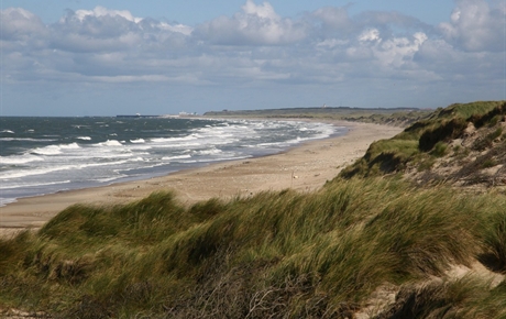
Location: Stenbjergvej 120, Snedsted, Jutland
Area: 244 km2 (94 sq mi) Map
Tel. +45 96 19 15 00
Official site
Thy National Park is an incredibly beautiful area that lies on the
Northern coast of Denmark in the Jutland region. It cover an area of
244 km2 (94 sq mi) of sand dunes, pastures, magnificent meadows and
picturesque views of the sea. Thy National Park is a famous for its
beautiful pristine nature, but it is also famous for remains of
military bunkers in the Museum of Hanstolm. It houses a collection
of bunkers and military defenses that date back to the Second World
War. They were constructed by the German military engineers as part
of the Atlantic Wall that was intended to defend continental Europe
against the Allied invasion. Here you will not only see them, but
also can learn about the layout and principles of their work.
Another interesting feature of the Thy National Park is the Aquarium
of the North Sea. Despite frigid temperatures, waters off the coast
of the nature preserve contain a rich diversity of animals,
crustaceous and other types of animals. Aquarium allows its visitors
to see these creatures up close without interfering or hurting this
unique preserve.
Why Visit?
Diverse landscapes in a compact area: beaches, dunes,
forests, lakes, and heathlands.
Excellent for hiking, biking,
birdwatching, surfing ("Cold Hawaii"), and wildlife spotting (red deer,
seals, migratory birds).
Free entry, open 24/7.
Relatively
uncrowded compared to more famous Danish spots, with a peaceful vibe.
Best Time to Visit
Summer (June–August): Warmest for
beach/swimming/surfing (highs ~20°C/68°F), longest days, but busier and
windier.
Spring (April–May) and Fall (September): Ideal
balance—milder crowds, great for bird migration, beautiful light, and
hiking. Early September often offers perfect weather.
Winter: Stark
beauty, fewer people, but cold, windy, short days, and some trails may
be flooded or icy.
Weather changes quickly on the coast—always check
forecasts. Wind is almost constant.
Getting There & Around
By
car (recommended): Easiest for flexibility. From Aalborg ~2 hours;
Aarhus ~2.5 hours. Ferries (e.g., Thyborøn–Agger) add scenic value.
Public transport: Possible via train/bus to Thisted or Hurup Thy, then
local buses, but limited and inconvenient for remote trails.
Inside
the park: Driving works well; many attractions have parking. Excellent
for cycling (West Coast Cycle Route, MTB trails). Bike rentals available
in towns like Klitmøller or Vorupør.
Pro tip: Download the official
National Park Thy app for interactive maps, trails, and facilities.
Top Attractions & Activities
Agger Tange (south): Bird paradise,
seals, straight coastal road, trails.
Lodbjerg Lighthouse & Sorte
Næse hike: Scenic loop with dunes, beach, and cliffs.
Stenbjerg
Landingsplads: Historic fishermen’s sheds, charming beach access.
Nørre Vorupør (Vorupør): Main visitor center (with wooden park model),
beach, seawater pool, lively village.
Klitmøller ("Cold Hawaii"):
Surfing hotspot.
Hanstholm: Lighthouse, bunkers, wildlife reserve
(red deer).
Other highlights: Isbjerg viewpoint, lakes (Nors Sø,
etc.), dune plantations, Bøgsted Rende.
Hiking: 49 marked trails,
from easy gravel paths to difficult sandy ones. The long West Coast
Trail/Rescue Road (part of ~94 km from Agger to Bulbjerg) is epic for
multi-day trips with shelters/campsites. Use AllTrails or the park app.
Other activities: Mountain biking, horseback riding, foraging (berries,
etc.), fishing, guided tours.
Practical Visiting Tips
Entrance
& Costs: Completely free. Some paid add-ons like certain museums or
guided tours.
Visitor Centers: National Park Center in Vorupør (main
one), smaller ones at Stenbjerg, Lodbjerg, etc. Great for maps and info.
Accommodation: No big hotels inside the core wilderness. Stay in coastal
villages (Klitmøller, Vorupør, Hanstholm, Agger) — hotels, guesthouses,
summer houses, or campsites. Book ahead in summer.
Food: Fresh
seafood in villages; limited options in remote areas. Pack picnic
lunches. Some places offer local brews and foraged items.
Facilities:
Toilets at visitor centers and popular spots. Limited shops—stock up in
towns.
What to Pack & Safety
Layers & weather protection:
Windbreaker/rain jacket (essential), fleece, quick-dry clothes, sturdy
hiking shoes (sand gets in everywhere).
Sun & wind: Sunscreen, hat,
sunglasses, lip balm.
Essentials: Water, snacks, binoculars (for
birds/wildlife), headlamp, basic first aid, power bank, map/app offline.
Insects: Some mosquitoes near lakes; bring repellent in summer.
Safety notes:
Respect no-entry zones (e.g., parts of Agger Tange and
Hanstholm for breeding wildlife).
Keep dogs leashed.
Strong
currents on beaches—swim only at designated/safe spots (e.g., Vorupør
pool).
Trails can flood or get muddy; check conditions.
Leave no
trace: Stick to paths, don’t pick plants, take trash out.
Wildlife
etiquette: Keep distance, especially in spring (breeding) and fall (deer
rutting).
Sample 1–2 Day Itinerary
Day 1 (South–Central):
Ferry to Agger → Agger Tange → Lodbjerg hike → Stenbjerg → Vorupør
(visitor center + beach).
Day 2 (North): Klitmøller → Hanstholm area
→ Isbjerg or other northern trails.
For a relaxed week, base in a
summer house in Nørre Vorupør and explore daily.
Thy National Park
rewards those who embrace its wild, windy character. It is perfect for
nature lovers seeking authentic Danish coastal wilderness without
massive crowds. Plan around the weather, bring the right gear, and enjoy
Denmark’s raw side.
Geological and Early Formation
The landscape of Thy was shaped by
powerful natural forces over millennia. At the end of the last Ice Age,
post-glacial rebound lifted the land as the ice receded. Around 7,000
years ago, much of western Thy was an archipelago in the Littorina Sea
(a higher sea level phase). Old coastlines from this period remain
visible inland, such as at Hanstholmskrænten, Isbjerg, Nors, and Vandet
Sø.
The area gradually rose and connected into the Thy peninsula
through sand and gravel accumulation. Early vegetation was primeval
forest, but by the Neolithic period (around 3950 BCE), climate shifts
brought storms, and farmers began clearing trees for fields and grazing.
By about 2500 BCE, much of the forest had given way to open, grazed
landscapes that persisted through the Bronze and Iron Ages.
Prehistoric and Ancient Human Activity
Human presence dates back to
the Stone Age, with settlements leaving traces like dolmens, burial
mounds, kitchen middens, and flint production sites. The Bronze Age saw
a thriving culture, evidenced by numerous barrows (especially near
Hanstholm); many more prehistoric remains were likely buried by later
drifting sands.
Activity continued through the Iron Age, Viking Age,
and Middle Ages, closely tied to the harsh North Sea environment.
Overexploitation through excessive grazing and deforestation stressed
the land, setting the stage for environmental collapse.
The Sand
Drift Era (Sandflugten)
From the Little Ice Age onward (particularly
mid-1500s to mid-1800s), severe sand drift plagued the region more
intensely than elsewhere in Denmark. Parabolic dunes advanced inland,
covering farms and fields across a 5–10 km (or wider) belt. By around
1800, dunes covered 18% of the modern Thisted Municipality area, with
additional heath and grazing lands exacerbating erosion as vegetation
was stripped for fodder and fuel.
This forced repeated relocation of
farms eastward, creating a stark divide: fertile moraine farmland to the
east versus barren, sandy coastal zones to the west. The Limfjord was
also affected, with sand blocking areas like Thyborøn and disrupting
infrastructure.
Efforts to Combat Sand Drift and Afforestation
Systematic intervention began with the 1792 Sand Drift Ordinance. In
1816, seven experimental plantations were established in Thy (e.g.,
Thagaards Plantation), but early attempts with grasses, trees, dikes,
and ditches largely failed due to the harsh climate.
Success came
later in the 19th century with hardier species like Austrian mountain
pine (bjergfyr), marram grass for stabilization, and others such as
Sitka spruce and Scots pine. Plantations like Hvidbjerg (1892) and
Stenbjerg followed, eventually creating a "carpet" of trees that
stabilized the dunes over more than a century. These efforts provided
jobs, timber, and new habitats (including for red and roe deer) but also
altered the natural dynamics.
20th Century and WWII
The 1930s
saw the creation of Hanstholm Vildtreservat (game reserve), Denmark’s
largest contiguous sandy heath area (~40 km²), which remains partly
restricted for bird breeding.
During the German occupation in World
War II, Thy’s strategic North Sea position led to heavy fortification as
part of the Atlantic Wall. Numerous concrete bunkers, batteries, and the
Hanstholm Fortress were built to control sea access, defend against air
attacks, and support broader operations. Many structures remain
today—some ruined, others restored as museums—serving as stark reminders
of the era.
Modern Establishment as a National Park
By the
late 20th/early 21st century, the stabilized landscape featured unique
dune heaths (among Europe’s largest continuous examples), plantations,
wet hollows, ponds, and rare habitats. Recognition of its biodiversity
value—rare plants, birds (e.g., European golden plover, cranes),
insects, and species like wolves occasionally returning—led to its
designation.
The park aims to protect characteristic Danish nature,
enhance biodiversity, and improve public access while preserving
cultural history. Today, management involves restoring some dynamism
(e.g., controlled burning, grazing, removing invasive trees, and closing
drains) to prevent overgrowth of the heaths, which depend on periodic
disturbance.
A modern National Park Center opened in Nr. Vorupør in
2021 as a hub for visitors.
Cultural and Historical Significance
The park preserves a layered history: prehistoric mounds, medieval
traces, fishing communities (e.g., preserved Stenbjerg landing site from
~1900), lighthouses (like Lodbjerg from 1883), and WWII relics. It
reflects centuries of human adaptation to a challenging coastal
environment.
Location and Size
The park lies in Northwest Jutland
(Nordvestjylland), along the exposed western coast facing the North Sea.
It stretches approximately 55 km (34 miles) north to south, from
Hanstholm in the north to Agger Tange in the south, and varies in width
from 5 to 12 km (3–7.5 miles) east to west. Its total area is 244 km²
(about 94 square miles).
It borders the Limfjord to the east in parts
and is flanked by traditional fishing communities and small villages.
The northern section includes the Hanstholm Wildlife Reserve (Hanstholm
Vildtreservat), while southern areas connect to Agger Tange, an
important bird area.
Overall Geography and Topography
The
landscape is low-lying and relatively flat, with average elevations
around 9–10 meters (30 feet) above sea level, though dunes and localized
features create more relief. It is a classic coastal dune and heath
landscape, formed by the interplay of sea, wind, sand, and salt. Key
elements include:
Coastline and Beaches: A long, wide, sandy
beach runs much of the park’s length, backed by dunes. The North Sea
delivers powerful waves and strong westerly winds, leading to ongoing
erosion and sediment transport. In places, there are dramatic eroding
coastal cliffs (such as at Lodbjerg) composed of sand and underlying
layers.
Dune Systems: High foredunes (primary dunes) stand closest to
the sea, often stabilized by marram grass (Ammophila arenaria). Inland,
there are extensive parabolic (horseshoe-shaped) dunes, dune slacks
(low-lying wet areas between dunes), and mobile or semi-stabilized sand
areas. Centuries of sand drift created vast "sand deserts" historically,
later partially stabilized by plantations.
Inland Mosaic: Behind the
dunes lies a patchwork of Atlantic dune heaths (unique on a large scale
globally), meadows, wetlands, conifer plantations, and over 200 dune
lakes (many small and nutrient-poor). Heathlands dominate with low,
hardy vegetation adapted to poor soils and wind.
Lakes and Wetlands:
Numerous small lakes and bog-like hollows (low-nutrient wet areas) dot
the landscape, formed in dune depressions. Larger examples include areas
around Lake Vandet or Ove Sø.
The terrain feels expansive and
open due to the wind-sculpted vegetation—trees (mostly conifers like
pine) often lean eastward from prevailing winds.
Geology and
Formation
The park’s features stem from post-glacial processes:
After the last Ice Age, post-glacial rebound lifted the land. Early
Stone Age remains (including from the Littorina Sea period) appear as
limestone cliffs or deposits along the coast and inland.
Sandy
sediments from the North Sea and glacial deposits formed the base.
Strong winds and sand migration (especially from medieval times onward)
created drifting sands that buried farmland, leading to "sand drift"
problems. In the 19th–20th centuries, large-scale planting of conifers
stabilized much of the area, though natural dune dynamics persist.
The underlying geology includes marine and glacial sediments, with
occasional chalk/limestone exposures. The landscape continues to evolve
through wind, wave erosion, and occasional storms.
Climate and
Environmental Influences
The climate is maritime and harsh:
Strong, persistent westerly winds from the North Sea carry salt spray
far inland, limiting vegetation.
Mild temperatures but frequent rain,
fog, and storms.
High exposure leads to a "wild" feel; the area is
often called Denmark’s closest equivalent to wilderness.
This
environment supports specialized ecosystems, notably large continuous
areas of Atlantic dune heath, which are rare globally.
Human
Influence and Current State
Historically, overexploitation and sand
drift turned parts into barren areas. Reforestation efforts created
plantations that now form part of the mosaic. Today, the park balances
conservation with limited traditional uses (e.g., some forestry,
grazing). It does not own all land but collaborates with landowners.
The park preserves cultural layers too—Bronze Age mounds, WWII bunkers
(Atlantic Wall remnants), and lighthouses like Lodbjerg Fyr—integrated
into the natural setting.
Visual and Experiential Highlights
Visitors encounter:
Vast sandy beaches with rolling waves.
Golden-yellow dunes topped with grasses and heather.
Wind-pruned
forests transitioning to open heath.
Tranquil dune lakes reflecting
the sky.
Dramatic views from clifftops or high dunes over the North
Sea.
Flora (Plant Life)
The vegetation reflects the nutrient-poor,
sandy, and often acidic soils, with strong influences from salt spray
and wind. Management practices like grazing by large herbivores,
controlled burning, and tree removal help maintain open heath habitats
against encroachment by scrub and trees.
Key habitats and
dominant species:
Dune heaths and sandy areas: Dominated by common
heather (Calluna vulgaris), bell heather (Erica cinerea), sand sedge
(Carex arenaria), marram grass (Ammophila arenaria — crucial for dune
stabilization), black crowberry (Empetrum nigrum, edible), and various
lichens. These create a low, varied cover that looks simple but supports
high plant diversity.
Wet hollows and bogs (dune slacks): Support
moisture-loving species such as bog bilberry (Vaccinium uliginosum),
bayberry (likely Myrica gale), marsh gentian (Gentiana pneumonanthe),
cranberry (Vaccinium oxycoccos), and insectivorous sundews (Drosera
species). These areas are botanically rich due to varying water levels.
Coastal dunes and beaches: Feature specialized plants like beach morning
glory (Calystegia soldanella) and the rare Scots lovage (Ligusticum
scoticum), both scarce in Denmark and mostly restricted to this west
coast.
Dune lakes and ponds: Host rare aquatic plants, including
water lobelia (Lobelia dortmanna), quillwort (Isoetes spp.), various
Chara (stoneworts), and the very rare slender naiad (Najas flexilis).
The pillwort fern (Pilularia globulifera), globally near-threatened,
also occurs here. Many lakes are exceptionally clean, making them
important for these indicator species.
Plantations: Mostly conifers
planted historically to combat sand drift. These introduced new habitats
but are managed to prevent overgrowth of the heath.
Edible and
notable plants: The park offers foraging opportunities for chanterelles,
boletes, cranberries, blackberries, whortleberries, black crowberries,
and sea-buckthorn. Some rare species (e.g., Scots lovage) are protected.
The Atlantic dune heath is of international importance, with
conservation efforts focused on preserving it as one of the largest
intact examples globally.
Fauna (Animal Life)
The park
supports a mix of coastal, heathland, wetland, and forest-adapted
species. Large mammals were re-established via plantations, while birds
benefit from protected breeding and resting areas.
Mammals:
Red deer (Cervus elaphus) — Denmark’s largest terrestrial mammal; roam
freely and are iconic. Large herds visible especially in autumn (rutting
season with roaring males). Best spotted at dawn/dusk from viewpoints
like Nors Lake.
Roe deer — Common in plantations and heath edges.
Harbor seals (Phoca vitulina) — Frequently seen resting on beaches,
especially between Hanstholm and Agger.
Otter — Found in lakes within
protected areas like Hanstholm Wildlife Reserve.
Other: Foxes, and
occasional wolves (rare vagrants or small presence; first modern
sightings around 2012 after historical extirpation).
Birds:
The park is a major ornithological site, with Agger Tange as one of
Northern Europe’s key resting areas for migratory waterbirds (tens of
thousands stop here) and Hanstholm Wildlife Reserve hosting over 30
breeding species. Parts are designated as Ramsar, Natura 2000, and bird
protection areas.
Notable breeders or residents:
Common crane
(Grus grus) — Breeds here; dancing displays in spring.
European
golden plover — Breeds in Hanstholm (nowhere else in Denmark).
Wood
sandpiper — Rare breeder in Denmark.
White-tailed eagle — Majestic;
often seen hunting near lakes (wingspan >2.5m).
Others: Eurasian
curlew, common snipe, black-tailed godwit (globally near-threatened),
Arctic terns, swans, ducks, and meadow birds.
Amphibians and
Reptiles:
Natterjack toad (Epidalea calamita) — Thrives in sandy
heaths.
Common European viper (Vipera berus).
Insects and
Others:
Diverse invertebrates, including many specialized for heath
and dune habitats. The large Hercules ant (Camponotus herculeanus)
occurs in some plantations and is rare elsewhere in Denmark.
Conservation and Experiences
Thy National Park emphasizes low-impact
visitation to protect fragile habitats and breeding wildlife. There are
seasonal access restrictions (e.g., breeding bird zones April–July) and
no-entry areas in sensitive spots like central Agger Tange and
Hanstholm.
It is an excellent place for hiking, birdwatching, and
nature observation. Key spots include Nors Lake for deer and eagles,
Agger Tange for migrants, and Hanstholm for heath birds and otters. The
raw, wind-swept landscapes provide a unique wilderness feel rare in
densely populated Denmark.