Location: Lapland/ Northern Ostrobothnia Map
Area: 270 km²
Official site
Oulangan National Park is located in Kuusamon kaupungisa and Sallan kunnassa Koillismaan ylänkö area. The park is bordered in the east by the Russian Federation, and in the back by the Paanajärven National Park, established in 1992, with which Oulanka cooperates continuously. Oulangan National Park is a diverse combination of northern, eastern and southern luontoa. The landscape is dominated by pine forest, jokilaakso koskinen and sandstorm, as well as extensive swamps in the northern part. The ecological system is rich and the area is home to many Uhanalais animals and birds. Kansallispuisto was founded in 1956. The area's current surface area is 270 km².
Geological and Natural Foundations
The park’s landscape was
profoundly shaped by the last Ice Age, which ended around 11,000 years
ago. Glacial activity and melting ice carved deep canyons and river
valleys, while "kettle holes" formed from melting ice blocks. The
Oulankajoki River (and its tributary Kitkajoki) and their rapids
(notably Kiutaköngäs and Jyrävä) are central features, creating
nutrient-rich soils that support diverse flora and fauna.
Post-glacial warming allowed species to disperse northward along river
valleys, resulting in a unique mix of northern, southern, and eastern
plant and animal species. This includes over 500 vascular plants, rare
orchids, and eastern species at their western limits. The area features
pine-dominated boreal forests, mires, and alluvial meadows.
Prehistoric and Indigenous History (Sámi Era)
The first known
inhabitants were Forest Sámi (a subgroup of the indigenous Sámi people).
They lived as hunter-gatherers, relying on fishing, hunting, and
foraging in the harsh subarctic environment. Evidence of Sámi presence
dates back centuries, with their culture adapted to the northern
forests.
Sámi occupation continued until the late 17th century. Place
names like "Kiutaköngäs" (meaning "large rapids in a deep gully" in
Sámi) reflect their linguistic legacy. As Finnish settlers arrived, the
Forest Sámi were largely displaced or assimilated, a pattern seen across
Lapland due to colonization, taxation, and land pressures.
Finnish Settlement and Traditional Use (17th–19th Centuries)
From the
end of the 17th century, Finnish settlers from the south moved in,
shifting the economy toward mixed livelihoods: hunting, fishing, and
later small-scale farming. A distinctive practice was haymaking on the
river’s natural flood meadows. Seasonal flooding created fertile
grasslands, which locals harvested for winter fodder. People traveled
long distances, staying in temporary meadow saunas for weeks amid
mosquitoes and hard labor.
Logging and floating timber down the
Oulankajoki River became important in the 19th century during Finland’s
"logging fever." Slash-and-burn agriculture was also practiced, and
reindeer herding (adopted from Sámi traditions) played a role. These
activities left cultural traces but remained relatively low-impact until
modern times.
Path to National Park Status (Late 19th–Mid-20th
Century)
Interest in protecting Oulanka grew in the late 19th century
amid rising conservation awareness in Finland. Key milestones include:
1917: An expedition funded by chocolate maker Karl Fazer surveyed the
area.
1920s: Botanist Professor Kaarlo Linkola conducted surveys for
state conservation, highlighting the area’s botanical value.
1938:
Finland established its first national parks, but Oulanka was not
included due to unclear land ownership and political issues.
1939–1945: World War II (including the Winter War and Continuation War)
delayed progress; the region saw military activity near the Soviet
border.
Post-war land reforms clarified ownership, separating
state and private lands. In the early 1950s, debates over harnessing
Kuusamo’s rapids for hydropower created "turbulence," but conservation
advocates prevailed. The opening of the famous Karhunkierros ("Bear’s
Ring") hiking trail in 1954 boosted tourism and public support.
Oulanka National Park was officially established in 1956, alongside
several other Finnish parks. This marked a shift from resource
extraction to preservation.
Expansions and Modern Development
(Late 20th–21st Century)
1982 and 1989: Significant expansions
increased the park’s size and protected more contiguous wilderness.
1966: The University of Oulu established the Oulanka Research Station,
which has supported long-term biological and geological studies.
2000s: Oulanka became part of the WWF’s PAN Parks network (one of the
first in Finland) for its high conservation standards. It is also a
Ramsar wetland site.
Cooperation with Russia’s Paanajärvi
National Park (established 1992) has grown since the Soviet era’s end,
creating a transboundary protected area that enhances biodiversity
conservation and tourism.
Today, the park attracts around
180,000–200,000 visitors annually. Tourism focuses on sustainable
activities like hiking the Karhunkierros trail, canoeing, and wildlife
watching. Traditional cabins and facilities are maintained for public
use.
Cultural and Conservation Significance
Oulanka represents
a transition from indigenous Sámi use and Finnish pioneer farming to
modern ecotourism and science. It preserves rare species, free-flowing
rivers, and cultural heritage (e.g., meadow traditions and logging
history) while facing challenges like climate change and balancing
visitor numbers with conservation.
Location and Setting
The park sits at approximately 66°22′N
29°20′E, roughly 25 km south of the Arctic Circle. It is about 50 km
north of Kuusamo (a key access town with an airport) and 40 km south of
Salla. Nearby villages include Käylä, Juuma, and Hautajärvi. The terrain
is remote and wild, part of the Fennoscandian Green Belt, with the
Oulanka River flowing northeast toward the White Sea (unlike most
Finnish rivers that drain south or west).
The park consists of two
main sections (northern and southern) separated by a small unprotected
gap. It features a transition zone where boreal forest meets subarctic
influences, creating diverse microclimates and habitats.
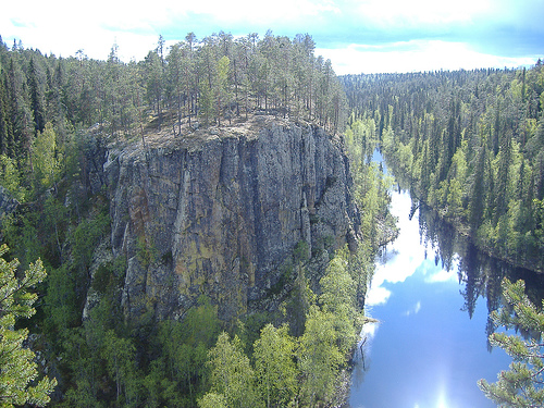
Topography and Terrain
Oulanka has relatively modest elevation for a
"rugged" area—average around 246 m, with small hills rather than high
mountains. The landscape is defined by river valleys, canyons, cliffs,
rapids, sandy banks, and mires, shaped dramatically by glacial and
fluvial processes.
Rivers and Canyons: The Oulanka River
(Oulankajoki) is the central feature, winding through the park with many
rapids (e.g., Kiutaköngäs, Taivalköngäs, Jyrävä) and carving deep
canyon-like valleys. These gorges have steep quartzite and slate cliffs,
some with iron-rich reddish rock. The river and its tributaries (like
Kitkajoki) create impressive waterfalls, hanging bridges over gorges,
and scenic viewpoints. Other features include sandy riverbanks and
alluvial meadows.
Mires and Wetlands: Northern sections feature vast
aapa mires (peatlands), which are wet and open, contrasting with the
forested river valleys.
Hills and Viewpoints: Named elevations are
modest but prominent locally:
Korvasvaara (highest, ~326–333 m), near
the Russian border.
Hiidenvaara (~270 m) and Jäkälävaara (~243 m),
accessible near trails.
Rocks, cliffs (e.g., Ristikallio,
Kallioportti), and free-standing formations like Rupakivi add dramatic
elements.
The terrain includes significant but manageable ups and
downs, making it popular for hiking (e.g., the famous 80+ km
Karhunkierros "Bear's Ring" Trail).
Geology
The park's
uniqueness stems from its bedrock and post-glacial history. The
underlying geology mixes hard quartzites with more easily weathered
slates, enabling canyon formation. A key feature is calcium-rich
dolomite and limestone (uncommon in much of Scandinavia), which overlies
older granites and gneisses. This neutralizes acidic soils, adds
nutrients, and supports richer vegetation than typical boreal areas.
The last Ice Age (~11,000 years ago) left a strong imprint: glacial
meltwater carved canyons and crevices, while retreating ice created
kettle holes and varied topography. The Oulanka River Valley served as
an important post-glacial dispersal corridor for species from the east.
Climate and Microclimates
Oulanka has a subarctic climate with
long, cold winters and short, sometimes surprisingly warm summers.
Varied topography (valleys vs. uplands, north- vs. south-facing slopes)
creates diverse microclimates that allow southern, northern, and eastern
species to coexist. The area experiences extreme seasonal contrasts,
including the "ruska" (autumn foliage) and polar phenomena near the
Arctic Circle.
Vegetation and Landscapes
The park exemplifies
untouched boreal (taiga) forest dominated by Scots pine, Norway spruce,
and birch, with herb-rich understories thanks to the nutrient-rich
soils. It includes:
Dense pine forests.
Lush groves and flood
meadows.
Peatlands/mires in the north.
Sandy beaches along rivers.
Over 500–600 vascular plant species thrive here, including rare
orchids like the Calypso bulbosa (park emblem). The limestone influence
boosts biodiversity far beyond typical acidic Finnish soils.
Summary of Geographic Appeal
Oulanka stands out for compressing
dramatic river-carved canyons, rapids, cliffs, mires, and biodiverse
forests into a compact area near the Arctic. Its geography blends
glacial legacy, unusual bedrock chemistry, and a position at biological
crossroads, making it one of Finland's most scenic and ecologically rich
national parks. The Oulanka River ecosystem ties it all together,
flowing across borders into Russia.
Various hiking trails provide an exciting opportunity to spend time
in nature all year round.
Kiutakönkään polku nature trail
Length 2 km. In winter and summer, the picturesque path along the
Karhunkierros (Bear Circle) route along the Oulanka River leads to the
turbulent Kiutaköngäs rapids.
Könkään kuohu trail
Length 150
m. The flat and gentle path is convenient for people with disabilities
and families with small children.
Kanjonin kurkkaus loop route
Length 6 km. The circular route through the forests in the northern part
of the national park offers many interesting obstacles: hills, ravines,
swamps, streams and a stunning canyon.
The Small Bear Circle
Nature Trail (Pieni Karhunkierros)
Length 12 km. An exciting
adventure among the breathtaking scenery along the banks of the
Kitkajoki River is suitable for a one-day hike. However, there are some
challenging places: three suspension bridges, wooden platforms and
stairs to overcome.
The Bear Circle Hiking Trail (Karhunkierros)
Length 80 km. One of the most popular hiking routes in Finland will take
you to the most beautiful views of the Oulanka National Park. The entire
route is designed for about 4-5 days, but you can hike only a certain
section of it. Along the way, you will encounter six suspension bridges,
as well as wooden platforms, stairs and footbridges. Despite its name,
the trail is not circular – it runs through the park from north to
south, and you can get to it from several points.
Birdwatching
On the banks of rivers, on the slopes of hills, in
forests or above the water, you can see countless birds that live here
all year round or fly in in the summer to build nests.
Fishing
You can fish with a rod on the Aventojoki, Savinajoki, Maaninkajoki and
Oulanka rivers, with the exception of protected areas where fishing is
prohibited. Also hidden among the dense forests of the national park are
numerous lakes. They are home to perch, grayling, pike, whitefish, but
you cannot catch the rare brown trout. Fishing is prohibited in the
lakes Aventolampi, Savilampi and Haaralampi.
Berries and
mushrooms
You can freely pick various mushrooms and berries in the
park - lingonberries, blueberries, strawberries. You will also find
exotic northern berries such as crowberries and cloudberries.
Rafting
An exciting canoe trip will allow you to look at the nature
of the park from a different perspective.
Bike rides
You can
ride mountain bikes along the 9-kilometer section of the Bear Circle
(Karhunkierros) trail from the Oulanka Visitor Centre to the
Taivalköngäs Waterfall, as well as along other public paths.
Skis
and snowshoes
The 26 kilometers of the difficult, but fascinating and
interesting Oulangan erämaareitti route will seem like a difficult test
even for experienced skiers and snowshoe hikers: there are no ski tracks
or lighting on the trail, but there are two warm huts for rest and a
campfire site along the way.
The Oulanka Visitor Centre is the heart of the national park. It
houses an exhibition about the nature and inhabitants of the area,
information about routes and attractions, and also offers maps, fishing
licences and equipment.
The Karhunkierros Nature Centre is located at
the start of the famous Karhunkierros hiking route and is ideal for
those planning to visit the northern part of the park.
The
Karhuntassu Information Centre in Kuusamo has detailed information about
the national park, the town itself and the Hannu Hautala Photography
Centre, a famous nature photographer and conservationist in
north-eastern Finland.
Hautajärvi Visitor Centre
The
325-metre-long Kiutaköngäs rapid is just a kilometre away from the
Oulanka Visitor Centre.
The Oulanka River Canyon is a mysterious
gorge with steep rocky banks, located about 2 km from the Savilampi
parking area.
Niskakoski Rapids. One of the 9 suspension bridges in
the national park spans the Kitkajoki River rapids in the southern part
of the national park. It is only 200 meters from the campsite and
parking area in Juuma village.
Jyrävä Waterfall. After 3.5 km from
the parking area in Juuma village, the Little Bear Circle (Pieni
Karhunkierros) nature trail leads to a stunning view of the majestic
9-meter waterfall on the Kitkajoki River.
Tents and shelters
In the national park, you can pitch a tent or
stay under a wooden shelter on specially equipped sites for free. It is
advisable to stay with a tent in one place for no more than two nights
in a row.
Forest huts
In Oulanka Park, there are 7 huts for
overnight stays and 2 cabins for daytime rest. Most of them are located
along the Bear Circle (Karhunkierros) route. Information about
accommodation in huts can be found at the visitor center.
Camping
In the central part of the park, along the Bear Circle (Karhunkierros)
route, a camping site is open throughout the summer. You can also stay
overnight in campsites or rented cottages in the village of Juuma.
Tourist complexes
Various accommodation options are available for
tourists in the city of Kuusamo and the Ruka ski resort, located 22
kilometers from the national park.
Campfires
Fire in the park is allowed only in specially designated
places. There are braziers and prepared firewood.
Garbage
It
is not customary to leave garbage in the park. Combustible waste can be
burned in a campfire, food waste can be thrown into a bio-toilet, other
garbage can be taken to special containers located at the entrance to
the park.
Animals
Domestic animals can only be walked in the
park on a leash. Hunting in the national park is prohibited.
Transportation
Motor vehicles can only be used on roads specially
marked on the map.