Location: Lapland Map
Area: 2550 km²
KoilliskairaVisitor center
Open: May- Sept
Mon- Fri 9am- 5pm
Sat- Sun 9am- 4pm
Tel. +358 (0) 205 64 7251
Urho Kekkonen National Park (Urho Kekkosen kansallispuisto, or UKK in Finnish; Urho Kekkonen álbmotmeahcci in Northern Sami) is one of Finland’s largest and most iconic protected areas, covering 2,550 km² (about 985 sq mi) in Finnish Lapland. It spans the municipalities of Savukoski, Sodankylä, and Inari, extending eastward toward the Russian border. It was officially established in 1983 and named after Urho Kaleva Kekkonen, Finland’s long-serving President (1956–1982) and an avid outdoorsman who frequently hiked and skied in the region.
The Kiehinen Visitor Center is located in Saariselkä,
where you can get all the necessary information about the national park,
book a hut, purchase a fishing license or a snowmobile permit and find
out how to get to the most picturesque places in this area of the park -
the Sokosti fells (Sokosti) and Ukselmapää, Pirunportti and Lumikuru
gorges, as well as look at Lake Luirojärvi.
The Korvatunturi visitor
center is the second nature center of the park, located in Savukoski.
Here you can learn about the history of the park, how to get to the
places of reindeer herders Suomujoki, Oskarinkoski, Raja-Jooseppi.
The visitor center "Tankavaara" (Tankavaara) is another tourist center
of the park, located in the Tankavaara area. Near the center there are
several marked trails for family walks, ranging in length from 1 to 7
km.
The German military base of the Second World War Schutzwall will
allow you to get acquainted with the military history of the last
century and see with your own eyes the military equipment of those
times.
Museum of Gold. Archived from the original on October 22,
2015. in Tankavaara is the world's only international museum of the
history of gold mining. The small village of Tankavaara, which has grown
into the Golden Village, is easily accessible by driving north on Route
4 from Sodankylä. Here you can learn interesting information about the
gold rush in Lapland, see real bars mined in this area and try yourself
as a real gold digger.
The top of the Kiilopää fell, from where you
can see the endless expanses of the national park.
Kaunispää fell in
Saariselkä with a beautiful landscape from above.
The national park is divided into two parts. The main
part, located in the Saariselkä area, is suitable for walking for a day.
And in Kemin-Sompio and Nuortti, you can go on a long hike through the
wild corners of nature.
Hiking
You can enjoy the unique nature
of the national park by walking along marked hiking trails. Around
Saariselkä and Kiilopää there are hiking trails with a total length of
about 200 km, 100 km of which lead to forest labyrinths, mountain peaks
and river banks of the national park.
Hiking trips
The wide
expanses of the national park offer tourists endless opportunities for
exciting adventures. To get off the marked trail, you need to be able to
navigate the terrain using a map and compass. To stop for the night in
the park, there are many public or rented forest huts, which are located
at a distance of one day's journey from each other. Near each place of
spending the night there is always a supply of firewood. The starting
point of the trip can be Saariselkä and Kiilopää, as well as Aittajärvi
and Raja-Jooseppi in the northern part of the park. Most of the unmarked
trails in the national park are of medium difficulty.
Fishing
In the lakes of the park, you can fish with a fishing rod for free or
engage in ice fishing. For other types of fishing you need to purchase a
license.
bird watching
On the trails near the village of
Tankavaara, there are two birdwatching towers, from where, in clear
weather, you can see a variety of inhabitants of the park - golden
eagle, kukshu, ptarmigan or golden plover.
Berries and mushrooms
Berries and mushrooms can be freely picked in any corner of the national
park.
Alloys
For kayaking or canoeing, the Luirojoki and
Kopsusjoki rivers are suitable.
Biking
4 special routes laid
through the picturesque area will allow you to go on an exciting journey
by bike.
Skis
Near Saariselkä, Kiilopää and Kakslauttanen
there are about 200 km of ski trails marked with wooden signs. The color
on the plates indicates the level of difficulty: a blue mark means an
easy route, a red one means an average one, and a black one means a
difficult one. Already in autumn, you can ride the Ensilumenlatu ski
track or the 25 km long illuminated pistes starting in Saariselkä. With
the advent of snow, the trails passing through the hills of the national
park open. On the way there are huts and sheds with fire pits.
On the territory of the national park is located:
5 huts for rest
37 huts and tents for general use or rented out for overnight stays
24 sheds with a campfire site
3 summer kitchens
5 plagues
about
130 designated campfire sites
Tents and awnings
Sheds, huts
and chums of common use are provided for spending the night in the
national park, and you can put up your own tent next to them. Also,
anyone can go to one of the 7 saunas in the park.
Forest huts and
plagues
The forest house can be booked for several days at the
visitor center.
Tourist complexes
Various accommodation
options are presented in the vicinity of the national park
Prehistoric and Indigenous History
Human presence in the
Koilliskaira (northeastern wilderness) area dates back at least 3,000
years, based on archaeological evidence. The region formed part of the
ancestral lands of the Forest Sami (also called Inari Sami or earlier
groups), who maintained four winter villages here. They used pitfalls,
fences, and other structures for hunting and trapping, many of whose
remains are still visible and protected within the park.
Later, Skolt
Sami (Koltta Sami) communities also left traces, including restored
settlements (Kolttakenttä). The Skolt Sami were among those displaced
after World War II from the Petsamo (Pechenga) area ceded to the Soviet
Union.
Reindeer herding has been central to Sami life for millennia.
The park lies within Finland’s reindeer husbandry region, where
traditional practices continue today alongside conservation goals.
Modern Sami herders in the area largely descend from Norwegian Sami who
arrived in the 19th century with larger herds.
Early Modern
Period (16th–19th Centuries)
Finnish settlers began arriving in the
1500s as farmers and cattle owners. This influx, combined with
Christianization efforts, gradually eroded traditional Forest Sami
culture and land use patterns. The area transitioned into important
grounds for Finns engaged in fishing, hunting, and pearl fishing (from
freshwater mussels in rivers).
Wild reindeer populations went extinct
in the 19th century due to overhunting and habitat changes, though
semi-domesticated reindeer herding persisted and remains vital. Place
names in the park are mostly Finnish but include some Sami origins,
reflecting this layered cultural history.
The harsh subarctic
environment—fells (tunturi), boreal forests, mires, river valleys (like
Suomujoki), and boulder fields shaped by the Ice Age—limited permanent
settlement, preserving much of the wilderness character.
20th
Century: From Wilderness to Protected Area
In the early 20th century,
the region saw limited activity such as gold prospecting (evidenced by
old huts like those in Rumakuru) and border-related settlement (e.g.,
Raja-Jooseppi homestead from 1910). World War II impacted Lapland
significantly, with evacuations and later reconstruction.
Post-war
Finland experienced economic pressures, including forestry expansion. By
the 1970s, growing environmental awareness and concerns over
deforestation in northern wilderness areas led to advocacy for
protection. Nature conservation groups, local initiatives, and
appreciation for the region’s unique landscapes drove the push for a
national park.
Key establishment milestones:
1980: The Finnish
Government adopted a resolution on September 2 to establish the park as
a major tribute to Urho Kekkonen, who had recently stepped down as
president and was a strong supporter of outdoor recreation and nature.
1981: A planning committee was formed.
1983: The park was officially
established and opened. This timing aligned with Finland’s broader
environmental movement in the late 20th century.
The naming
honored Kekkonen’s personal connection to the area and his role in
Finnish politics during a period of neutrality and national development.
It was the second-largest national park at the time (after Lemmenjoki).
Modern Era and Management
Managed by Metsähallitus (Finland’s
state forest and park service), the park forms part of the Natura 2000
network (UK-puisto-Sompio-Kemihaara). It balances strict conservation
with sustainable use: marked trails in western sections (near Saariselkä
and Kiilopää) for easier access, while eastern and southern wilderness
zones remain remote.
Reindeer herding and limited traditional uses by
locals and Sami continue with exceptions in regulations. The park
protects diverse habitats: fell heaths, spruce/pine forests, aapa bogs,
river valleys, and canyons like Paratiisikuru. Wildlife includes bears,
wolverines, wolves, golden eagles, and abundant reindeer.
Korvatunturi (a fell partly in the park and border zone) is famously
regarded in Finnish folklore as the home of Santa Claus (Joulupukki),
adding cultural significance.
Visitor numbers have grown
significantly (over 435,000 in 2024), supported by visitor centers like
Kiehinen in Saariselkä and trails such as the Nuorttijoki circle or
routes to Sokosti (the highest fell at 718 m). Historic sites include
old Sami villages, wartime remnants, and cultural heritage trails.
Size, Location, and General Setting
Area: Approximately 2,550 km²
(985 sq mi), making it the second-largest national park in Finland.
Coordinates: Roughly centered around 68°20′N 28°00′E, well north of the
Arctic Circle.
Establishment: Founded in 1983 and named after Urho
Kekkonen, Finland’s long-serving president and prime minister, who had a
strong personal connection to Lapland.
The park forms part of a
larger conservation network, including adjacent areas like the Sompio
Strict Nature Reserve and Kemihaara Wilderness Area. It is a true
wilderness with varying levels of accessibility: the western sections
near Saariselkä and Kiilopää offer marked trails suitable for day hikes,
while the eastern and central wilderness areas are remote and best
suited for experienced multi-day backpackers.
Topography and
Landscape Features
The park is renowned as Finland’s most mountainous
national park, featuring 99 named peaks (fells or tunturi). These are
not sharp alpine mountains but ancient, rounded, gently sloping hills
characteristic of the Fennoscandian Shield.
Fells (Tunturi): The
Saariselkä fell line runs through the heart of the park. Key summits
include:
Sokosti (718 m / 2,355 ft) — the highest peak, with
excellent panoramic views.
Ukselmapää (701 m).
Vuomapää (691 m).
Others like Lumipää, Kuikkapää, Reututunturi, etc. (many between 600–700
m).
Above the treeline, the fell tops are barren, windswept
heathlands covered in lichens, mosses, dwarf shrubs (e.g., crowberry,
Alpine bearberry), and sedges. They offer open, rugged vistas.
Valleys and Gorges: Dramatic features include Paratiisikuru (Paradise
Gorge), a deep ravine with cascading waterfalls, steep walls, and lush
vegetation contrasting the surrounding plateaus.
Forests: Extensive
old-growth boreal (taiga) forests dominate lower elevations, primarily
Scots pine and Norway spruce. Forests thin out with elevation and become
sparse or absent on higher fells. Northern parts have more pine/spruce,
while southern areas feature more wetlands.
Wetlands and Mires: Vast
peat bogs (suo), string bogs, and marshlands are scattered throughout,
especially in flatter areas between fells. These are important for
biodiversity and carbon storage.
Rivers and Lakes: The park is a
major watershed. Notable rivers include the Suomujoki (flowing
northward), Luirojoki, Kopsusjoki, Repojoki, Luttojoki, and
Muorravaarakkajoki. Some drain toward the Arctic Ocean, others toward
the Gulf of Bothnia. The Kemijoki (Finland’s longest river) originates
in or near the park. Lakes such as Harrijärvi, Luirojärvi, and
Aittajärvi dot the landscape, often with wilderness huts along their
shores.
The terrain was heavily shaped by the last Ice Age, resulting
in glacial deposits, boulders, gorges, and smoothed fell landscapes.
Geology
The park lies on the ancient Baltic Shield, one of the
oldest parts of the Earth’s crust (1.5–3 billion years old). Dominant
rocks include granites, gneisses, shales, and quartzites. The fells are
eroded remnants of the ancient Karelides mountain range, which once
rivaled the modern Alps in height but has been worn down over eons.
Glacial activity left behind moraines, erratics (large boulders), and
the current rounded topography.
Climate
As an inland
Arctic/subarctic location:
Summers: Short and relatively mild (around
20°C daytime highs), with nearly 24-hour daylight (Midnight Sun) in
June–July. Mosquitoes can be abundant.
Winters: Long, dark, and cold.
Polar night (kaamos) brings minimal daylight; temperatures often range
from -20°C to -30°C, occasionally dropping to -50°C. Heavy snowfall and
strong winds on fells increase wind chill. Aurora Borealis is common.
Precipitation: 400–500 mm annually, relatively low but with significant
snow cover in winter.
Weather changes rapidly, especially on exposed
fells.
Human and Cultural Geography
Reindeer herding by Sámi
people remains an active traditional livelihood. The park preserves
cultural heritage alongside nature, with wilderness huts (kämppä),
trails, and historic sites. Access points include Saariselkä (western
gateway), Kiilopää fell center, and Raja-Jooseppi. Korvatunturi (486 m),
in a remote border area, is famously known in Finnish folklore as the
home of Santa Claus (access restricted).
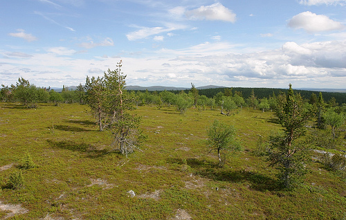
The extensive area of the national park includes fells as well as
wide swamp areas and forests. The northern part of the national park
consists of a fell area. Mainly birch trees grow here, the higher
elevations are unforested and only covered by lichens. The highest fell
in Urho Kekkonen National Park is Sokosti at 718 m. Also the
Korvatunturi, according to the Finnish popular belief the homeland of
Santa Claus, is located in the area of the national park directly on the
Russian border. In the south-west there are wide aap bogs, which serve
as breeding grounds for numerous birds. The southern part of the
national park is occupied by extensive pine and spruce forests, from
which occasional fells rise. At Saariselkä in the north of the national
park, the spruce reaches the northern limit of its range, north of which
only pines are found.
A total of 130 bird species breed in the
national park, including mountain finches, warblers, meadow pipits,
redwings, redpolls and rare species such as the golden eagle, gyrfalcon
and peregrine falcon. Siberian jays, Lappland tits and three-toed
woodpeckers are found in the wooded areas. Golden plovers and morellel
plovers live on the unforested fells. The moorland provides habitat for
species such as the wood sandpiper, ruff and snipe.
Urho Kekkonen
National Park is home to 21 different species of mammals, including all
four of Finland's large carnivores (brown bear, wolf, lynx and
wolverine), as well as reindeer, moose, rabbits, foxes, shrews, moles,
pine martens, stoats, little weasels and otters. In addition to numerous
trout, the river pearl mussels also live in the rivers of the national
park. The adder reaches the northern limit of its range here.
The Urho Kekkonen National Park, with its extensive wilderness areas, offers opportunities for challenging multi-day hikes or ski tours. For less experienced hikers, there are shorter marked hiking trails of one to seven kilometers in the western part of the national park in Kiilopää, Tankavaara and Saariselkä.
Campfires
Lighting a fire in the park is allowed only in
specially designated places, on recreation areas. There are braziers and
prepared firewood. You can always use your own burner. Open flames are
prohibited during the fire hazard period. It is recommended to check the
weather conditions and warnings in advance before the trip.
Garbage
It is not customary to leave rubbish in the park. Combustible
waste can be burned in a fire, food waste can be thrown into the dry
closet, other garbage can be taken to special containers located at the
entrance to the park.
Animals
Pets can only be walked in the
park on a leash.
Transport
On the territory of the national
park it is forbidden to move on a motorcycle and a car.
Other
Only local residents can hunt in the park. It is not allowed to collect
stones, as well as damage the soil and rock topography.