Location: Hesse Map
Construction: started in 1222
First owner: Diether IV of Katzenelnbogen
Official site
Auerbach Castle is located in the Southern Hesse region in Germany. The original Auerbach Castle was constructed on the site by Emperor Charlemagne of the Holy Roman Empire. In 1222 it was completely reconstructed by Diether IV of the Katzenelnbogen dynasty. During the Thirty Years' War the Auerbach Castle was badly damaged, greatly undermining its military role. Its last straw was Franco-Dutch War (1672–1679), when in 1674 French Marshal Turenne stormed the military citadel killing civilians that looked for safety inside its ruins. Military fortifications of the Auerbach Castle fell in disrepair. It underwent renovations in the late 1980's and open to the public.
Early Context and Founding (8th–13th Centuries)
The site’s history begins long before the castle itself. In 773,
Holy Roman Emperor Charlemagne donated lands in the area (including
the future village of Auerbach) to the influential Lorsch Abbey. The
town of Auerbach was first documented around 784 in the Lorsch Codex
as “Urbach” (“owl brook” or similar, from Old High German). For
centuries afterward, the region lay in relative obscurity under
monastic and local control.
In 1135, through the marriage of
Hildegard von Henneberg, significant territories along the
Bergstraße passed to Count Heinrich II von Katzenelnbogen (ennobled
as an earl in 1138 by King Conrad III). The County of Katzenelnbogen
was later divided into Upper (southern Hesse) and Lower (Rhine area
around St. Goar) counties. The counts grew wealthy from Rhine tolls
and needed to secure their southern holdings and control the ancient
north-south trade route along the Bergstraße (a road used since
Roman times).
Construction of Auerbach Castle began around 1222
(or possibly as early as 1230) on the orders of Count Diether IV von
Katzenelnbogen. Its location on the Urberg was chosen for its
commanding position to deter enemies, protect toll collection at
nearby Zwingenberg, and safeguard the Upper County. The earliest
historical reference to a castle on the Urberg dates to 1247 (as
Feste Urberg), with the first direct mention of the castle itself in
1257. It quickly became the largest and most important fortress on
the Bergstraße.
13th–14th Century Expansion and Peak Power
The castle was initially a typical high-medieval fortress with a
triangular inner bailey (core courtyard)—a hallmark of
Katzenelnbogen construction style—grouped around a deep 62-meter
(203 ft) well drilled through bedrock for water supply. It featured
an inner and outer bailey (zwinger), multiple towers (including a
central keep/donjon), living quarters, a grand hall, chapel,
kitchens, stables, and smithy. A strong shield wall protected the
vulnerable sides.
A major turning point came on 18 October 1356,
when the powerful Basel earthquake (one of the strongest in central
European history) shook the Upper Rhine Valley and caused the
original keep to collapse onto eastern buildings. Starting around
1370, the counts undertook an extensive renovation and modernization
program that transformed the castle into one of the most advanced
fortifications of its era. Key upgrades included:
Demolishing
the ruined keep and relocating the entrance to the southwest,
protected by a new south tower and inner bailey.
Building a
massive 4-meter-thick bastion (one of the earliest in Germany
designed specifically to withstand emerging cannon fire) in place of
the east tower.
Raising and reinforcing the north and south round
towers.
Strengthening the northern shield wall.
These
changes earned it the nickname Feste Urberg (“Urberg Fort”) and made
it highly defensible against both traditional siege weapons and
early gunpowder artillery. For roughly 200 years, it served not only
as a military outpost but also as the administrative seat for the
Upper County, with an Amtmann (bailiff) in residence.
Transition to Hesse and Decline in Military Role (15th–17th
Centuries)
In 1479, the entire County of Katzenelnbogen—including
Auerbach Castle—passed by inheritance to the Landgraviate of Hesse.
Under Hessian rule, the castle gradually lost its frontline
strategic importance as warfare and administration evolved. By the
time of the Thirty Years’ War (1618–1648), it was no longer actively
used for military purposes, though it still offered refuge to
locals.
Its final destruction came in 1674 during the
Franco-Dutch War (1672–1679). French forces under Marshal Turenne
(fighting on Hessian soil against the Holy Roman Empire) stormed and
burned the castle. Tragically, many local civilians who had sought
shelter inside were killed. The medieval fortifications proved no
match for 17th-century artillery and tactics.
From Ruin to
Romantic Icon (18th–19th Centuries)
After 1674, Auerbach Castle
stood as an abandoned, fire-scarred ruin. In 1820 the north tower
collapsed, prompting the Hessian authorities to secure the site and
partially rebuild it in a style influenced by the emerging
Burgenromantik (castle romanticism) movement. Battlements were added
to the residential building to evoke a more “medieval” look, and
other romanticized Gothic elements (such as a pointed-arch window
and renovated gate/bridge in 1903) were introduced. An inn opened in
the former bailey in 1888, turning the ruins into a popular
excursion destination for summer visitors from the nearby
Fürstenlager spa.
A remarkable natural landmark also emerged: a
stunted Scots pine (Waldkiefer), now over 300 years old, rooted in
the battlements of the northern shield wall. It draws moisture from
the air and has become an unofficial symbol of the castle’s
resilience.
Modern Era and Preservation (20th–21st Centuries)
In the 20th century, further restorations enhanced public access. A
terraced restaurant opened in 1990, and in 2007 the south tower’s
staircase was rebuilt, allowing visitors to climb it once more (the
north tower had been accessible earlier). The site now hosts
medieval-themed events, dinner theater, and knight tournaments. The
outer grounds are freely accessible daily, and viticulture continues
on the historic slopes (vineyards recorded as early as 1258).
Today, Auerbach Castle remains a beloved landmark and testament to
medieval engineering, the rise and fall of noble dynasties, and the
19th-century romantic fascination with ruins. Its
architecture—triangular courtyard, massive towers, thick bastions,
and deep well—illustrates the evolution from pure defense to
representative residence and then to obsolescence in the face of
gunpowder warfare.
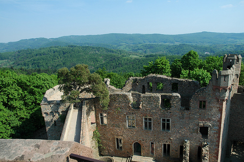
Auerbach Castle (Schloss Auerbach or Burg Auerbach) is a ruined
medieval hilltop fortress perched on the Urberg (Auerberg) hill
above Bensheim-Auerbach in southern Hesse, Germany, along the
historic Bergstrasse trade route. It offers panoramic views over the
Rhine plain and Odenwald forest. Constructed primarily in the 13th
century by the Counts of Katzenelnbogen (with possible earlier
Carolingian roots attributed to Charlemagne), it exemplifies early
medieval defensive architecture that was extensively modernized in
the late 14th century to counter emerging cannon technology—one of
the earliest such adaptations in Germany.
The castle’s most
distinctive feature is its triangular inner bailey (Kernburg), a
signature design of Katzenelnbogen castles and among the earliest
examples of this layout in Germany. This triangular courtyard formed
the core of the fortified residence, enclosed by a robust
~10-meter-high ring wall originally strengthened by round towers at
each corner.
Overall Layout and Defensive System
The
castle featured multiple concentric defensive layers typical of
13th–14th-century German hill castles:
Inner bailey: Triangular
courtyard at the heart, housing key domestic and military
structures.
Narrow zwinger (killing ground or outer ward): A
confined space between the inner ring wall and outer defenses.
Outer bailey/forecourt: An additional enclosed area with a second
ring wall; the main estate entrance was originally on the south side
of this outer wall.
Moat and access: A 10-meter-deep trench (on
the vulnerable northeast side) crossed by a bridge led to the inner
areas, with gates protected by murder holes and arrow slits.
This layered system maximized defensibility on the hilltop site
while controlling tolls on the vital north-south trade route.
Original 13th-Century Construction (c. 1222–1250s)
Built
around 1222 under Count Diether IV von Katzenelnbogen, the castle
began as a classic medieval stronghold. It had:
Three round
towers at the corners of the triangular keep.
Original entrance:
Located in the curtain wall between the north tower and the
(now-lost) east tower/bergfried (donjon/keep), heavily protected by
the bergfried itself.
North-to-south wall structures: Kitchens,
living quarters for the garrison (Burgmannenwohnung), stables, and
smithy.
East-to-south wall structures: The multi-story palas
(residential hall building), cellars, grand hall, and castle chapel.
Central well: A remarkable 62-meter-deep shaft drilled straight
through solid bedrock in the east corner of the inner courtyard,
ensuring water supply during sieges.
The palas between the
north and south towers served as the primary living space; its
ground floor likely functioned as the Dürnitz (a heated dining and
communal room).
Major 14th-Century Reconstruction (~1370,
after 1356 Earthquake)
A powerful earthquake on 18 October 1356
collapsed the east bergfried (keep) and damaged southeastern
buildings. This prompted one of the castle’s most significant
architectural upgrades under the Counts of Katzenelnbogen,
transforming it into the Feste Urberg (“Urberg Fort”)—a cutting-edge
defensive complex:
Polygonal bastion: The collapsed east
tower was replaced by a massive, quarter-circle or polygonal bastion
with 4–5-meter-thick outer walls. This was one of the first
artillery-resistant bastions in Germany, designed specifically to
withstand and return cannon fire from the northeast. It included a
cannon platform with battlements.
Towers: The north and south
round towers were likely heightened; they remain the defining
elements of the castle’s silhouette today.
Entrance relocation:
The main gate moved to the southwest corner, protected by the south
tower (which contained a dungeon) and an inner courtyard.
Shield
wall enhancements: The northern shield wall was closed, raised, and
reinforced.
These changes made Auerbach one of the most
modern and secure castles of its era in the region.
Interior
Features and Surviving Elements
Inside the triangular bailey
(still visible today):
The palas/residential building (between
north and south towers) was a multi-story structure with cellars.
Remnants include window openings and 19th-century additions.
The
southeast area housed the grand hall, cellars, and chapel; the
chapel’s distinctive Gothic window frames (pointed arches with
tracery) remain largely intact despite the loss of wooden floors and
roofs.
Along the north-south wall: Foundations and wall traces of
kitchens, living quarters, stables, and smithy.
A
centuries-old Scots pine (over 300 years old) dramatically roots
into the curtain wall near the north tower, adding to the romantic
ruin aesthetic.
Later History and 19th–20th-Century
Modifications
The castle lost military relevance by the 16th
century and was largely abandoned after the Thirty Years’ War. In
1674, during the Franco-Dutch War, French troops under Marshal
Turenne destroyed it by fire, leaving the impressive ruins seen
today.
In the 19th century (Castle Romanticism era), the
Landgraviate of Hesse stabilized the ruins:
The north tower
(which collapsed in 1820) was partially rebuilt.
Crenellated
battlements were added to the western residential building’s upper
level for a more “picturesque” medieval look (original structure was
likely two stories without them).
In 1903, a Gothic-style
pointed-arch window and steps were added to the hall; the southwest
gate and bridge were renovated.
A restaurant/inn was built in
the former bailey in 1888 (later expanded with terracing in the
1980s–90s). The south tower’s staircase was restored in 2007, making
both main towers accessible for 360° views.
Current State as
a Ruin
Today, Auerbach Castle is a well-preserved and accessible
historic monument managed by the State of Hesse. Its twin round
towers dominate the skyline, while the triangular bailey, thick
bastion, deep well, and Gothic chapel remnants allow visitors to
trace the evolution from 13th-century knightly fortress to
14th-century gunpowder-era stronghold. The site combines raw
medieval engineering with romantic 19th-century enhancements, set
against stunning natural scenery.