Location: Geislingen an der Steige, Baden- Württemberg Map
Constructed: 12th century by Eberhard von Helfenstein
Helfenstein Castle stands in Geislingen an der Steige, Baden- Württemberg region of Germany. Helfenstein Castle was constructed in the 12th century by Eberhard von Helfenstein. The stronghold is perched on a mountain at an elevation of 610 meters above sea level. From here Counts of Helfenstein could control Fils Valley and an important trade route. Invention and wide use of firepower forced defenders to increase military fortifications to keep up with the growing offensive power. Eventually this medieval castle lost the competition. During Second Margrave War the castle fell in 1552 to armies of Margrave of Ansbach. The structure of the captured citadel was badly damaged. The walls and towers of Helfenstein Castle were eventually abandoned and rediscovered only by archeologists in the beginning of the 20th century. Expedition here worked on cleaning the forest under supervision of Georg Burkhardt between 1932 and 1938.
Origins and Construction (Early 11th–12th
Centuries)
The castle was constructed around 1100 by Eberhard von
Helfenstein (also known as Eberhard the Elder or possibly Eberhard
von Stubersheim-Helfenstein), the first reliably documented member
of the family. It was built on a naturally defensible mountain spur
ideal for surveillance and defense. While written records point to
c. 1100, archaeological evidence suggests earlier activity: ceramics
dating to the early 11th century were uncovered during a wall
collapse on Christmas 2022, hinting at possible pre-1100 structures
or settlement.
The original complex consisted of three concentric
rings or wards: a core castle (Kernburg), an outer bailey with farm
buildings, and additional defensive elements. Key surviving or
reconstructed features include parts of the defense wall, a southern
gate, a rainwater cistern, and rondels (round bastions). The site’s
location at a critical trade route junction quickly made it
economically vital.
The family’s coat of arms featured an
elephant (Elefant), a canting pun on “Helfenstein” (sounding like
Elefantenstein or “elephant stone” in German).
Rise of the
Counts of Helfenstein (12th–14th Centuries)
Under the
Hohenstaufen emperors, the Helfensteins rose to regional power. The
castle was frequently enlarged and strengthened between c. 1100 and
1380, evolving from a basic stronghold into a more elaborate
residence and administrative center.
The family acquired
additional territories through strategic marriages and inheritance,
including the counties of Spitzenberg (c. 1200–1296) and
Sigmaringen. By the mid-14th century, they controlled a largely
contiguous lordship encompassing Geislingen, Heidenheim an der
Brenz, Blaubeuren, and Wiesensteig. In 1356 the house split into two
main branches: the Helfenstein-Wiesensteig line (which retained the
castle and Geislingen) and the Helfenstein-Blaubeuren line.
The
castle remained the family’s primary residence and symbol of power
during this golden age, though the broader political instability
following the Hohenstaufen collapse in the mid-13th century led to
regional conflicts in which the Helfensteins participated.
Decline, Transfer to Ulm, and Fortification (Late 14th–Early 16th
Centuries)
Financial difficulties—exacerbated by expensive
marriages (such as Ulrich V’s union with Maria of Bosnia) and the
costs of maintaining extensive lands—forced the Wiesensteig branch
to pledge the castle and much of the county to the Free Imperial
City of Ulm in 1382 as collateral for a large loan. Unable to repay
the debt (123,439 gulden), they ceded the castle, Geislingen, and 27
villages or hamlets outright to Ulm in 1396.
Ulm, recognizing the
site’s strategic value in an era of emerging gunpowder artillery,
transformed the medieval castle into a modern fortress. They
constructed outer Zwinger walls with rondelles (round defensive
towers), a bulwark toward Weiler, and integrated the nearby rocky
outcrop of the Ödenturm (built c. 1420 specifically as a cannon
platform to protect against artillery). The original palas
(residential hall) was converted into a comfortable residence for
the Ulm-appointed Burgvogt (castellan). The forward bailey became
the Vogt’s seat, heavily fortified against heavy guns, with the
“Darliß” serving as the main gun tower.
Destruction in the
Second Margrave War (1552)
The castle’s final chapter came during
the Second Margrave War (also linked to the broader Schmalkaldic
conflicts). In Easter week 1552, it surrendered without a fight to
troops of Margrave Albrecht Alcibiades of Brandenburg-Kulmbach. Ulm
forces recaptured it in August after a short bombardment using heavy
stone cannonballs. Rather than risk it falling into enemy hands
again, Ulm deliberately demolished (geschleift) the fortress shortly
afterward. Building materials were partly reused in Ulm itself. The
site was left to decay and gradually became overgrown with forest.
Post-Destruction: Ruins, Excavations, and Modern Era (16th
Century–Present)
A first scholarly history of the castle was
written in 1796 by Georg Veesenmeyer. Serious archaeological work
began in 1922 under Konrad A. Koch; major excavations from 1932 to
1938, assisted by army engineer troops and led by local researcher
Georg Burkhardt, uncovered foundation walls and artifacts now
displayed in Geislingen’s Museum im Alten Bau. Reconstructions were
guided by romanticized 16th-century descriptions of the buildings
and inventory, resulting in rebuilt sections such as a south tower,
stairs, wooden bridges, and a lookout tower on the former palas
site.
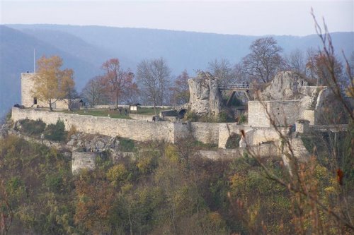
Today the ruins form an impressive, atmospheric site with
panoramic views over the Filstal valley and Swabian Alb. It is
accessible via hiking trails (including a modern bridge), features a
small tavern in season, and is a highlight on the Straße der Staufer
(Staufer Route) tourist trail. From 1983 to 2012 it hosted the
annual Helfensteinfestival, a rock/punk music event. The site
remains a popular destination for hikers and history enthusiasts.
Construction History and Architectural Evolution
The castle was founded around 1100 by Eberhard (the Elder) von
Helfenstein as the ancestral seat of the Counts of Helfenstein. Early
construction used local rubble stone (Bruchstein) with ashlar (Quader)
elements for structural strength, typical of Swabian high-medieval spur
castles. It began as a basic rock-integrated fortress with a core on the
central spur, basic curtain walls, and a keep (Bergfried), leveraging
steep slopes and natural rock outcrops.
By the early 14th century,
under the Helfenstein counts (who rose in prominence through ties to the
Hohenstaufen emperors), it expanded into a princely residence with a
Palas (main residential hall) in the western section, economic
buildings, and courtyards. After 1382 (as a pledge) and full acquisition
by the Free Imperial City of Ulm in 1396, major modernization occurred
to counter firearms: the old castle was encircled by a Zwinger (outer
defensive ring/corridor), the keep was converted into a "Mauerhaus"
(wall house), and the forecastle (Vorburg) around two rock formations
was heavily fortified. A bulwark extended toward Weiler ob Helfenstein,
incorporating the "Unteren Wiesle" terrace and the nearby Ödenturm rocky
outcrop (a separate 33 m forward watchtower built c. 1400). The Palas
was repurposed as a comfortable residence for Ulm's Burgvogt (bailiff).
The castle was damaged and systematically demolished by Ulm forces in
1552 during the Second Margrave War (after brief occupation and
artillery bombardment). Remaining walls were further dismantled in 1760;
the site became overgrown until 20th-century excavations.
Layout
and Defensive Architecture
Helfenstein was designed as a classic spur
castle, with the narrow ridge limiting the plan to a linear, elongated
form optimized for the topography. The layout comprised three concentric
rings:
Kernburg (core/inner bailey): Centered on the highest
rock, enclosed by a thick Mantelmauer (mantle or shield wall). It
included upper and lower burghöfe (courtyards), a deepened neck ditch
(Halsgraben, up to 11 m, repurposed as a cistern), and section moats
(Abschnittsgräben) around outcrops. A viewing platform now sits on a
central rock, reached via stairs and a wooden bridge.
Middle ward
(Restburg): Contained residential and support buildings, including the
Palas, armory, bakehouse, and powder storage. This ring housed the main
living quarters.
Outer ring and Zwingeranlage: The most distinctive
late-medieval feature—an outer fortified corridor with six rondels
(round bastions) on the south, west, and east sides for artillery
flanking fire. These circular bastions (Rondelle) improved defense
against cannon fire compared to square towers. Additional elements
included flank towers (e.g., south and north flankers), a shell tower
(Schalenturm), a gate tower, and Gothic gate/portcullis remnants.
Natural rock features like the Darliß outcrop were incorporated as
strongpoints.
Key defensive innovations post-1396 included the
Darliß (a massive gun tower/bastion on a rock in the forecastle,
dominating the complex and resistant to heavy artillery) and reinforced
Zwingermauern (Zwinger walls). The entire system combined man-made walls
with steep slopes and integrated rock formations for layered defense.
Materials and techniques: Primarily local limestone rubble masonry for
walls (often breast-height in restorations), with dressed ashlar for
corners, gates, and towers. Vaulted cellars (Gewölbekeller) and cisterns
ensured water supply during sieges.
Key Structures and Features
Palas and Observation Tower: The western Palas foundations now support a
rectangular ~9 m high Aussichtsturm (observation tower, built 1934) with
an attached Burgschenke (castle tavern/inn) on the east side, offering
panoramic views.
Towers and Bastions: Remnants of the Darliß gun
tower, six Zwinger rondels, and flankers (some partially rebuilt,
including a south tower during 1930s works). The nearby Ödenturm served
as an advanced outpost.
Gates and Access: Southern main gate
(Torhaus) with an embedded Helfenstein family coat-of-arms relief and a
plaque commemorating Count Ulrich V and Duchess Marija Kotromanić (who
resided here 1356–1396). Modern access includes a new steel bridge at
the northeast and an old wooden bridge at the southeast.
Cisterns and
Support: Rainwater cisterns in both upper and lower courtyards (one 11 m
deep).
Current State and Restorations
Excavations began in
1922 (K.A. Koch) and intensified 1932–1938 under Georg Burkhardt (with
army engineer support and city funding), clearing foundations and
partially restoring walls, the south tower, stairs, and bridges to a
romanticized historical state. A 2008 renovation and ongoing maintenance
preserve the site. Today, it is a freely accessible ruin with
substantial wall remnants (many to breast height), the 1934
tower/tavern, and interpretive elements. Finds (ceramics, artifacts) are
in the local Museum im Alten Bau. The ruins convey the scale of a
once-imposing fortress while highlighting its integration with the
dramatic Swabian landscape.
The castle complex can be reached barrier-free from a parking lot located below Weiler on the K 1441 district road via a farm road and a newer steel bridge that was built on the northeast corner of the castle. Further access is via footpaths on the west side and via the old wooden bridge on the south-east corner of the facility.
From 1983 to 2012, the Helfenstein Festival, a music event (genre rock / punk), took place at the castle every year. The ruin has been an important sight on the Staufer road since 1997.