Location: Lonetal, Baden-Württemberg Map
Constructed: 12th century by Henry of Kalden
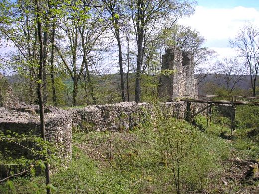
Ruins of medieval Kaltenburg Castle stands near Lonetal, Baden-Württemberg region of Germany. Kaltenburg Caslte was originally constructed in 12th century by the orders of Henry of Kalden who also gave the name to a Kaltenburg Fortress. The place was chosen wisely as a strategic location on top of the 60 meter high hill above confluence of rivers of Lone and Hurbe rivers. Military fortifications of the citadel were badly damaged by the siege of 1435 by the Nürnberg armies. The final nails were deadly shots fired in 1632- 34 in the coarse of the Thirty Years' War. Kaltenburg Castle was abandoned after portions of the South West wall have collapsed. Although some local peasants were squatting on the grounds of the former Kaltenburg Castle, the fort itself was never used again for its primary purpose.
The ruins of the hilltop
castle are at 510 m above sea level. NN about 60 meters above the
confluence of the Hürbe and Lone on the Taleck.
About 500
meters north of the Kaltenburg is the entrance to the
Charlottenhöhle, one of the longest show caves in the Swabian Alb.
Origins and Early Construction (12th–13th Centuries)
The castle
was likely founded between 1150 and 1180 during the High Middle Ages
under the Hohenstaufen (Staufer) emperors. Its name probably derives
from its founder or first lord, Heinrich von Kalden (also known as
Heinrich von Pappenheim or Bappenheim), a prominent imperial
ministerialis (unfree knight in service to the emperor) and
Reichshofmarschall (imperial marshal) under Frederick I Barbarossa and
his successors. As a loyal Staufer vassal, he helped establish the
castle as a reichsunmittelbar (imperially immediate) fortress—directly
subject to the emperor rather than local lords.
The initial structure
was a simple tower house (Turmhaus) built on the highest point of the
rocky outcrop, featuring thick Romanesque masonry (including
characteristic humpback ashlar blocks). It began as a defensive outpost
at a strategic valley crossroads. Four distinct construction phases are
still visible in the ruins today:
Phase 1 (12th century) — Core
tower house with an integrated shield wall (Schildmauer).
Phase 2
(13th–14th centuries) — Major expansion to roughly its present size,
including curtain walls, a neck ditch (Halsgraben), and outer bailey
elements.
Phase 3 (1450–1560) — Further fortifications and
residential upgrades.
Phase 4 (post-1630s) — Partial Baroque-era
rebuild.
Early documentary mentions include Dietmar von
Kaltenburg (1240) and Otto von Kaltenburg (1265), confirming the
presence of a noble family tied to the site.
Medieval Ownership
and Expansion (14th–16th Centuries)
By the early 14th century, the
castle passed out of direct imperial control. In 1332, it came under the
Counts of Helfenstein, with Heinz Vetzer serving as administrator
(Vogt). In 1357, the Lords (Herren) of Riedheim took possession, holding
it as a fief from the Duchy of Bavaria or as bailiffs (Vögte) for the
Imperial City of Ulm. Parts were later shared with families such as von
Grafeneck and Stadion.
The castle was expanded into a more complex
defensive complex: an irregular pentagonal outer curtain wall
(Zwingermauer) with round towers on the hillside, a deep angled neck
ditch (5 m deep, 10–16 m wide) on the vulnerable attack side, and a
southern gatehouse near the steep cliff drop. A prominent Romanesque
shield wall (up to 4 m thick and 13 m high in places) and remnants of
the inner core (including a possible keep site) protected the plateau.
It featured two separate burghills (northern older core and southern
extension) connected by walls, plus a palas (residential hall) and
chapel. By the 15th–16th centuries, it had grown into a sizable fortress
with living quarters, stables, and outbuildings.
Key Conflicts
and the Thirty Years’ War (15th–17th Centuries)
In 1435, the castle
was besieged and damaged by troops from the Imperial City of Nuremberg.
The attackers reportedly used a large cannon nicknamed the
“Kaltenburgerin” during a feud involving a sheltered noble (possibly
linked to the Roßhaupter family).
The most devastating blow came
during the Thirty Years’ War (1618–1648). In 1632–1634, Swedish forces
largely destroyed the castle. A new cattle shed had been built in 1621,
but it offered little protection. The Riedheim family later rebuilt
parts in 1677, adding the two prominent square towers (Vierecktürme) on
the valley side with pyramidal roofs—these became landmarks still
visible today.
Decline and Partial Habitation (18th–19th
Centuries)
Post-war recovery was limited. In 1764, the southwest
building collapsed; its stone was carted off to build a farmstead in
nearby Reuendorf. By 1800, the site was described as dilapidated. The
castle chapel was demolished in 1804, and further inner structures were
dismantled or collapsed around 1806 (though some repairs, like to a
bridge and well, occurred then).
In 1820, the Counts of Maldeghem
acquired the ruins. It remained partially inhabited: five families lived
there around 1820, rising to about 30 residents by 1837. The gatehouse
(Torhaus) stayed occupied until around 1897. After that, it fell fully
into ruin and was occasionally used as a quarry.
20th–21st
Century Preservation and Modern Status
Serious conservation began in
the 20th century with security works in 1938 and 1940, followed by more
extensive efforts in 1980–1983 (including tower stabilization). A tower
roof collapsed in 1976, highlighting ongoing decay.
A turning point
came in December 2015 when the Interessengemeinschaft Kaltenburg e.V. (a
local citizens’ association) purchased the site. Between 2016 and 2018,
they carried out major restorations: closing wall gaps, securing the
shield wall, and making the ruins safer and more accessible. In 2017,
the shield-wall work earned it “Monument of the Month” recognition from
the Baden-Württemberg Monument Foundation. By 2020, information panels
were installed, gravel paths laid, and the site approved as an event
venue. It now hosts guided tours (typically two Sundays per month),
cultural events, and is open to hikers.
Today, substantial ruins
remain walkable: large sections of the pentagonal curtain wall,
round-tower stumps (some restored), the two Baroque square towers,
shield walls, moat remnants, and gate foundations. The site is a
protected cultural monument and a highlight of the Swabian Alb’s “castle
landscape,” blending medieval history with natural beauty.
Burg Kaltenburg (Kaltenburg Castle) is a ruined medieval spur castle
(Spornburg) in the Lonetal (Lone Valley) of the Swabian Jura,
Baden-Württemberg, Germany. It lies on a rocky plateau at about 510 m
above sea level, roughly 60 m above the valley floor where the Hürbe and
Lone rivers meet, between Hürben (part of Giengen an der Brenz) and
Burgberg (Niederstotzingen).
The castle’s architecture evolved
through four clearly distinguishable phases from the High Middle Ages
onward. It began as a simple Romanesque tower house and grew into a
complex, irregular pentagonal fortified complex with multiple curtain
walls, towers, moats, and a double-core layout. Though ruined (with some
sections collapsed and others heavily restored), substantial wall
remnants survive, offering a textbook example of medieval defensive
evolution—from early Staufer-era tower-house design to later
artillery-adapted enclosures and post-Thirty Years’ War Baroque repairs.
Site and Topography
The castle occupies an elongated rocky spur
(the “Burgfelsen”) that rises sharply from the valley. The main approach
is from the south near a steep drop, while the flatter northern
(mountain) side required stronger artificial defenses. A wedge-shaped
neck ditch (Halsgraben) — about 5 m deep and 10–16 m wide — protected
the vulnerable attack side. An older Staufer-era moat section survives
in the northwest behind the outer wall, where the core rock rises
dramatically. The layout divides into a northern (older) core on the
highest rock outcrop and a southern extension on an adjacent, slightly
lower hill, separated by an internal Halsgraben. This “double castle”
arrangement enhanced internal security.
Construction Phases and
Key Architectural Features
Phase 1: 12th Century (c. 1150–1180) –
Romanesque Tower House (Kernburg)
The original castle consisted only
of a tower house (Turmhaus) built directly on the rocky outcrop. A
massive shield wall (Schildmauer) formed the east side of this nearly
square structure: up to 3.4 m thick, with remnants standing 4 m high and
16 m long on the plateau. The rock itself rises to 13 m; scattered large
ashlars (Quader) around it are all that remain of the tower and possible
Palas (main residential hall) to the west on a lower ledge. This phase
shows classic Romanesque fortification: thick, integrated shield walls
for passive defense against the steep valley drop, minimal openings, and
reliance on natural topography.
Phase 2: 13th–14th Century –
First Major Expansion
The complex grew to roughly its present size.
The southern curtain wall (Ringmauer) of this phase partially survives,
including the gatehouse (Torbau) near the steep southern cliff. At the
southwest corner, a second shield wall (about 10 m long, 7–8 m high, 2.2
m thick) rises above the ditch; remnants of a vaulted passage at 5 m
height and six field-side openings suggest a wooden hoarding
(Hurdengalerie) or fighting gallery for enfilading fire. Enclosing walls
of later Riedheim extensions are also visible here. The inner core now
included a possible keep positioned west of the original rock on deeper
bedrock.
Phase 3: 1450–1560 – Late Medieval Outworks and Zwinger
Further defensive upgrades created the irregular pentagonal
outer/Zwinger wall (Zwingermauer), reinforced by two square towers and
three (possibly four) protruding round towers (some as shell
towers/Schalentürme). The Zwinger (bailey-like outer enclosure) at the
southwest corner is especially clear. Round-tower stumps on the mountain
side have been heavily restored but reflect 15th/16th-century artillery
adaptations (rounded forms better resisted cannon fire). A Palas rebuild
and additional residential/outbuilding elements likely occurred here.
The overall layout became a concentric system with the inner Kernburg
protected by the outer ring.
Phase 4: 1677 onward – Post-Thirty
Years’ War Reconstruction
After near-total destruction in 1632–34,
the von Riedheim family rebuilt from 1677. They added the two prominent
square towers (Vierecktürme) on the valley side — tall, plastered
structures crowned with pyramid roofs. These Baroque-style towers
dominate views from the valley and serve as the castle’s visual
landmarks. They flank the southern approach and integrate with the older
ring wall. The southwest building collapsed in 1764 (material reused
elsewhere), but the towers survived. Later 19th–20th-century works
(1938–40, 1980–83) secured and partially rebuilt them.
Defensive
System and Materials
Walls: Thick quarry-stone masonry
(Bruchstein/Quader), some with bossed ashlars (Buckelquader) typical of
Swabian Romanesque work. Shield walls provided passive strength; later
ring walls allowed active defense via wall-walks and galleries.
Towers: Romanesque keep remnants (northwest); 15th/16th-century round
towers (foundations/stumps); 17th-century square towers (plastered,
pyramidal roofs).
Gate and Access: Southern gatehouse (foundations
only); former drawbridge over the Halsgraben.
Moats and Outworks:
Deep neck ditch on the attack side; inner Zwinger for layered defense.
Other Features: A chapel (demolished 1804); limited residential traces
(no intact Palas interiors remain).
Construction used local stone
for durability against the exposed plateau. Later phases incorporated
more refined ashlar work and plaster for the Baroque towers.
Current State and Visitor Experience
Today, Burg Kaltenburg is a
substantial but overgrown ruin with walls up to 13 m high. The two
square towers, restored gatehouse area, shield-wall fragments, and
Zwinger outlines are the most visible elements. The site is freely
accessible (short walk from parking), with information panels, gravel
paths, and occasional guided tours or events. A 3D model by the State
Office for Monument Preservation (available via the IG Kaltenburg
association) lets visitors explore the phased layout virtually.
The
architecture vividly illustrates the transition from early medieval
tower-house strongholds to more sophisticated concentric fortifications
and, finally, to post-war residential/representative rebuilding — all
shaped by the dramatic Swabian Jura landscape.