Location: Lower Saxony Map
Area: 345,800 ha
Tel. +49 4421 9110
The Lower Saxon Wadden Sea National Park (German: Nationalpark
Niedersächsisches Wattenmeer) is a vast, highly biodiverse protected
area along the North Sea coast of Lower Saxony, Germany. Established
in 1986, it covers approximately 345,800 hectares (about 3,458 km²)
and includes the East Frisian Islands, extensive mudflats, salt
marshes, beaches, dunes, and estuaries. It forms part of the larger
Wadden Sea, a UNESCO World Heritage Site (inscribed 2009, with
extensions), recognized for its unique intertidal ecosystem and
exceptional biodiversity.
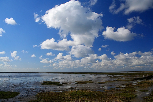
The park is one of the world's largest
unbroken systems of intertidal sand and mudflats, shaped by dynamic
tidal processes. Twice-daily tides deposit sediments, creating a
highly productive environment—second only to tropical rainforests in
biomass production. Over 10,000 animal and plant species are
recorded, with up to 4,000 specialized for this food-rich habitat.
Best Time to Visit
Spring (March–May): Excellent for birdwatching
as millions of migratory birds stop over. Milder weather and fewer
crowds.
Summer (June–August): Warmest for beach activities, mudflat
walks, and family visits. Peak season brings more crowds, especially on
weekends and islands.
Autumn (September–October): Great for bird
migration (e.g., Migratory Bird Days), fewer people, and good weather.
Seal watching is reliable.
Winter: Quieter and atmospheric, but
colder, windier, and with limited guided activities. Good for dramatic
storms if prepared.
Tides dictate everything—always check local
tide tables. Mudflat hiking is best around low tide.
Getting
There
By car/train: Main access points include Cuxhaven (east),
Wilhelmshaven, Norden/Norddeich, and towns like Bensersiel or
Carolinensiel. Deutsche Bahn serves many coastal spots with connecting
buses.
Ferries: To the East Frisian Islands from specific mainland
harbors (e.g., Norden to Norderney/Juist, Bensersiel to Langeoog).
Schedules are tide-dependent—check in advance.
Airports: Nearest
major ones are Bremen or Hamburg, then train or drive.
Popular
bases: Cuxhaven (spas, easy island access), Wilhelmshaven (Jade Bay), or
Norden (western mudflats).
Key Activities and Experiences
Mudflat Hiking (Wattwanderung): The signature activity. Walk barefoot or
in boots/socks across the exposed seabed with a certified guide. You'll
see lugworms, crabs, birds, and possibly seals. Never go alone—tides can
turn quickly and create dangers like quicksand-like areas or channels.
Seal Watching: Boat trips or walks to observe harbor and grey seals on
sandbanks. The seal sanctuary in Norden-Norddeich is great for learning
about rescues.
Birdwatching: World-class for waders, geese, and
raptors. Best during migrations. Respect breeding seasons (April–July
restrictions in some areas).
Island Exploration: Ferry or walk (at
low tide with guide) to islands like Neuwerk. Enjoy beaches, dunes, and
relaxed vibes. Some islands are car-free.
Visitor Centers and
Education:
UNESCO centers in Cuxhaven and Wilhelmshaven (exhibits,
aquariums, audio guides).
National Park Houses on islands and
mainland (e.g., Baltrum, Carolinensiel, Fedderwardersiel).
Interactive displays, microscopes for tiny creatures, and guided
programs.
Other Options: Beach relaxation, kiteboarding/surfing
(in designated areas), cycling, horse-drawn carriages on mudflats,
lighthouse visits (e.g., Obereversand), or boat trips.
Zoning and
Rules — Respect the Park
The park has three zones for protection:
Zone I (Quiet/Restricted, ~68.5%): Strictest; enter only on guided tours
or marked paths.
Zone II (Intermediate, ~31%): Marked trails most of
the year; bird breeding restrictions April–July.
Zone III
(Recreation, ~0.5%): Beaches for swimming, relaxing, sports.
Key
rules:
Stay on marked paths where required.
No dogs off-leash
(disturb wildlife); often banned in sensitive areas.
No
camping/bivouacking in most zones, no drones, no littering, no
disturbing animals.
Follow "Leave No Trace" principles—take nothing
but photos (shell collecting limited).
Guides and rangers enforce
these and provide safety.
Practical Visiting Tips
Safety
First: Tides are the biggest risk—use guides for mudflats. Check weather
(changeable, windy, rain possible anytime). Wear layers, waterproof
gear, and sturdy shoes/boots. Sun protection in summer.
What to
Bring: Binoculars, camera, tide chart app, snacks, water, insect
repellent (sometimes), and cash for ferries/guides.
Accessibility:
Some centers and beaches are accessible. Wattmobiles (special buggies)
available in places like Cuxhaven for mobility needs.
Costs: Park
entry is free. Guided walks ~€10–20/person. Ferries and visitor centers
have fees. Accommodations range from campsites to hotels/apartments.
Guided Tours: Book via visitor centers or nationalpark-partner sites.
Certified guides are highly recommended.
Sustainability: Support
eco-friendly operators. The area is sensitive—minimize disturbance to
birds and seals.
With Kids: Interactive centers and easy beach/mud
play are perfect. Seal stations and aquariums engage them.
Accommodations and Food
Stay in coastal towns or on islands for
immersion. Many options offer sea views or wellness (North Sea spas
popular). Fresh seafood (fish, shrimp) is a highlight—try local spots in
harbors.
The Wadden Sea offers a profound, slow-paced nature
experience unlike anywhere else. Plan around tides, book guides for core
activities, and embrace the rhythms of the sea for a memorable,
educational visit. For latest info, check official sites like
nationalpark-wattenmeer.de or niedersachsen-tourism.com.
Early Human Interaction and Pre-Protection Era
The Wadden Sea
region has a long history of human interaction shaped by its
dynamic, harsh environment. For centuries, local communities adapted
to tidal forces through dike-building, land reclamation, and
embankment systems to combat flooding and gain agricultural land.
The landscape was often viewed as hostile rather than valuable for
conservation—subject to modification for flood control, ports, and
infrastructure.
By the early 20th century, small nature reserves
emerged on some islands, primarily to protect birdlife amid growing
awareness of exploitation risks. Post-1950s economic growth
accelerated human impacts: expanded flood defenses, port
development, large-scale tourism infrastructure, and damming of
tidal inlets. Tourism became economically significant, but it also
increased pressure on the ecosystem.
Scientifically, recognition
grew of the Wadden Sea's exceptional productivity (second only to
tropical rainforests in biomass) and its role as a critical stopover
for millions of migratory birds along the East Atlantic Flyway,
supporting over 10,000 animal and plant species.
Path to
National Park Status (1970s–1986)
International conservation
frameworks provided the foundation:
1971 Ramsar Convention:
Designated the areas (including Dollart Bay) as wetlands of
international importance.
1976: Specific Ramsar listing for
Wattenmeer, Ostfriesisches Wattenmeer & Dollart.
Key
milestones in the 1980s:
1979: Scientists Hans-Joachim Augst and
Holger Wesemüller submitted a report proposing a zoning model based
on ecological sensitivity.
1982: Lower Saxony's regional
development program set a goal for a national park covering the East
Frisian Islands and coast.
1983–1984: Detailed planning began;
the state cabinet approved the park in principle.
January 1,
1986: The national park regulation officially came into force,
making it the second German Wadden Sea national park after
Schleswig-Holstein (1985).
The park aimed to conserve natural
processes with minimal human disturbance while balancing traditional
uses like limited fishing, agriculture, and tourism.
Post-Establishment Developments and Challenges (1986–2000s)
1992:
The entire park was designated a UNESCO Biosphere Reserve under the
"Man and the Biosphere" program, emphasizing sustainable development
alongside conservation.
1999: A dedicated National Park Law
replaced the initial 1986 regulation, strengthening legal
protections.
2001 Amendments and Controversy: In July 2001,
the Lower Saxon State Parliament amended the law, removing or
downgrading protection for many areas (over 80 sites, mostly on East
Frisian Islands) to support tourism and local economies.
Compensatory additions included offshore areas near Borkum and
Baltrum and the eastern Dollart nature reserve, increasing the total
size from ~240,000 to nearly 280,000 hectares.
This sparked
backlash from conservation groups like the Wattenrat Ost-Friesland,
who filed a 2002 complaint with the EU Commission alleging
violations of Natura 2000 directives (Birds and Habitats
Directives). The EU eventually closed the case in 2006 after Germany
proposed additional Special Areas of Conservation, but critics
argued it prioritized economics over ecology.
The park is zoned
into three levels:
Zone I (Quiet Zone): ~68.5% — Strictest
protection; limited access.
Zone II (Intermediate): ~31% —
Moderate access on designated routes.
Zone III (Recreation):
~0.5% — Focused on tourism.
UNESCO World Heritage and
International Recognition (2009 Onward)
2009: Inscribed as part
of the Wadden Sea UNESCO World Heritage Site (with Dutch and
Schleswig-Holstein German sections) under criteria (viii), (ix), and
(x) for its geological processes, ecological importance, and
biodiversity. Hamburg's section was added in 2011; Denmark's in
2014.
This status highlighted the Wadden Sea as the world's
largest unbroken intertidal sand and mudflat system with largely
undisturbed natural processes. It reinforced trilateral cooperation
(Netherlands-Germany-Denmark) via the Trilateral Wadden Sea
Cooperation and Plan.
The park forms part of the Natura 2000
network and is a Particularly Sensitive Sea Area (PSSA). It faces
ongoing management balancing strict conservation with tourism,
sustainable fishing, and climate adaptation (e.g., sea-level rise
and sediment dynamics).
Broader Context and Cultural Heritage
Archaeological efforts (e.g., projects since 2012 by institutions
like NIhK) document submerged or eroding cultural layers, including
medieval settlements, revealing thousands of years of human
adaptation to a changing coastline.
Visitor centers (e.g., in
Wilhelmshaven, Cuxhaven, Norderney) and guided activities like
mudflat hiking educate the public while promoting low-impact
tourism.
Location and Boundaries
The park stretches approximately 200–250
km along the coast, from the Bay of Dollart (Dollart) on the
Dutch-German border in the west to Cuxhaven and the Outer Elbe shipping
channel in the east. It encompasses:
Extensive intertidal mudflats
and shallows between the mainland and the barrier islands.
The East
Frisian Islands (Ostfriesische Inseln) chain.
Associated salt
marshes, beaches, dunes, tidal creeks, estuaries, sandbanks, and some
offshore sea areas.
It covers about 345,800 hectares (3,458 km²
or roughly 1,335 sq mi), making it one of the largest national parks in
Germany. The park is zoned for protection:
Zone I (Quiet Zone):
~68.5% — strictest protection, limited access.
Zone II (Intermediate
Zone): ~31% — regulated access.
Zone III (Recreation Zone): ~0.5% —
for tourism.
The southern boundary generally follows the mainland
dikes, while the northern edge extends into the North Sea beyond the
islands. It lies between the Ems and Elbe river estuaries.
Physical Geography and Geology
The Wadden Sea is the largest unbroken
system of intertidal sand and mud flats in the world. Its defining
feature is extreme shallowness:
The seabed slopes very gently,
descending only a few centimeters per kilometer in many places
(typically no more than 10 meters deep in the main tidal basin).
Twice-daily tides (semidiurnal, with a range often >1.7–3 meters) expose
vast areas of seabed at low tide and flood them at high tide, creating a
constantly shifting landscape of mudflats, channels, and sandbanks.
Key landforms include:
Mudflats (Watten): Dominated by fine silt,
clay, and sand. Rich in organic matter from river sediments (Ems, Weser,
Elbe) and marine deposits. Lugworms and other invertebrates rework the
sediment.
Tidal creeks and channels: Deeper, persistent waterways
that drain the flats.
Salt marshes: Develop in higher, less
frequently flooded areas near the mainland and islands. They feature
specialized halophytic (salt-tolerant) vegetation.
Dunes and beaches:
Primarily on the northern and eastern sides of the islands. Wind-blown
sand from exposed flats builds dunes stabilized by marram grass
(Ammophila arenaria). These act as natural breakwaters.
Sandbanks and
shoals: Dynamic, shifting features.
Estuaries and bays: Such as the
Jade Bay (Jadebusen), with unique features like sandy cliffs near
Dangast and Cuxhaven, brackish reed beds, and even a rare "swimming bog"
at Sehestedt.
The East Frisian Islands form a protective barrier
chain 3–10 km offshore. From west to east, the main ones in or bordering
the park include Borkum, Juist, Norderney, Baltrum, Langeoog,
Spiekeroog, and Wangerooge. Smaller or uninhabited ones include Mellum,
Memmert, Minsener Oog, etc. These are low-lying barrier islands shaped
by waves, tides, wind, and longshore drift. Many are migrating eastward
over time.
Climate
The region has a temperate maritime climate
influenced by the North Sea:
Mild winters and cool summers.
Frequent strong winds, storms, and high humidity.
This open, treeless
character (unlike tropical mangroves in similar tidal conditions)
results from the temperate setting combined with high tidal energy and
salt exposure.
Dynamic Processes
The park is highly dynamic
due to:
Sediment transport: Rivers and tidal currents deposit and
redistribute sand, silt, and clay.
Erosion and accretion: Islands and
coastlines are constantly reshaping. Dunes and sandbanks provide
protection against North Sea storms.
Tidal forcing: Creates one of
the most productive ecosystems on Earth (second only to tropical
rainforests in biomass per area), fueled by nutrient-rich waters and
constant mixing.
This makes it a prime example of ongoing
geomorphological processes in a coastal wetland environment.
Ecological Significance
The geography supports exceptional
biodiversity:
Over 10,000 species of plants and animals.
Critical
stopover for millions of migratory birds (waders, geese, ducks).
Habitats for seals, fish, invertebrates, and specialized flora like sea
lavender and beachgrass.
The combination of shallow gradients, tidal
rhythm, sediment supply, and temperate climate creates a unique, highly
productive transitional zone between land and sea.
Key Habitats
The park features diverse, interconnected habitats
that support specialized life:
Mudflats (Watten): The core
habitat—vast areas exposed at low tide. They teem with microorganisms,
diatoms, and invertebrates that fuel the food web.
Salt Marshes:
Develop where sediment builds up beyond regular tidal flooding. These
host highly specialized plant communities and support around 400 insect
species on just 25 plant species.
Dunes and Beaches: Primarily on the
north and east sides of islands. Beach grass (Ammophila arenaria)
stabilizes dunes with deep roots, protecting against erosion.
Estuaries and Channels: Mix of fresh and saltwater, supporting brackish
species.
Sea-grass Meadows and Mussel Beds: Underwater features that
provide nurseries and food sources.
These habitats are dynamic,
influenced by tides, wind, and sediment flow, allowing natural processes
to continue largely undisturbed in core zones.
Flora (Plants)
The flora is adapted to extreme conditions: high salinity, periodic
flooding, strong winds, and shifting substrates. Key examples include:
Salt Marsh Plants: Glasswort/Salicornia (a pioneer species that
tolerates high salt), Sea Aster, Sea Lavender (blooms in summer, adding
color), and other halophytes.
Dune Stabilizers: Beach grass/Marram
grass, which anchors dunes and prevents sand erosion.
Seaweed and
Algae: Various species in intertidal zones, including those in mussel
beds and channels.
Other Specialists: Sea holly in salt marshes;
plants in brackish reed areas (e.g., in Dollart Bay or Weser mouth).
Salt marshes alone support around 2,300 species of flora and fauna
combined. The park's plant diversity contributes significantly to the
overall ecosystem productivity, with many species uniquely adapted to
the Wadden Sea's transitional zones.
Fauna (Animals)
The fauna
is exceptionally rich due to abundant food resources. The Wadden Sea
acts as a critical "larder" for the North Sea.
Invertebrates
(Foundation of the Food Web)
These dominate biomass and are essential
for higher trophic levels:
Lugworm (Arenicola marina): Iconic
"ecosystem engineer" living in U-shaped burrows in sandy mudflats;
produces characteristic coiled casts. Millions inhabit the flats.
Cockles: Filter feeders that process seawater.
Mud Snails and Shore
Crabs: Abundant on the surface and in shallows.
Brown Shrimp: Key
species in the food web.
Other: Diatoms, worms, mussels, sand lice
(up to millions per area), and thousands of other benthic invertebrates.
Densities can reach impressive numbers (e.g., thousands of cockles or
mud crabs per square meter in prime spots).
Birds
The park is
globally significant for avian life, especially along the East Atlantic
Flyway:
Migratory/Wintering Birds: Up to 10–12 million waders, geese,
ducks, and gulls pass through annually. It supports huge numbers of
bar-tailed godwits, dunlins, Brent geese, barnacle geese, and others.
Millions rest and feed here to build fat reserves.
Breeding/Moulting:
Pied avocet, terns (including little tern), shelducks (nearly the entire
NW European population moults here in summer), eiders (breeding and
moulting), and gulls.
Salt Marshes: Prime breeding areas for avocets
and terns.
Marine Mammals
Harbour Seal (Phoca vitulina): Most
common; hauls out on sandbanks.
Grey Seal (Halichoerus grypus):
Increasingly present; uses sandbanks for breeding/moulting.
Harbour
Porpoise (Phocoena phocoena): Regularly sighted in channels and coastal
waters.
Fish and Others
Nursery grounds for North Sea fish
species (e.g., plaice, herring).
Other marine life in channels and
meadows.
Ecological Importance and Conservation
The Wadden
Sea's productivity supports not just local species but migratory
populations across continents. It is a Ramsar Wetland, Biosphere Reserve
(since 1992), and part of Natura 2000. Zoning includes strict "quiet
zones" (Zone I, ~68.5% of the area) with limited access to minimize
disturbance.
Challenges include climate change (sea-level rise),
fisheries, tourism, and pollution, but strong protections help maintain
its status as one of Europe's premier natural areas.