Location: North of Kandern Map
Constructed: 1246 by Counts von Hachberg
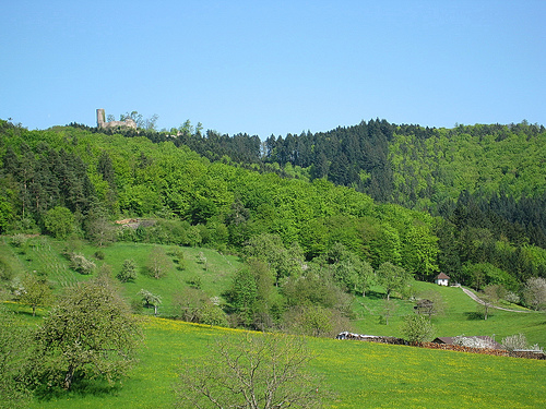
Sausenburg Castle located in the heart of the Black Forest, North of Kandern in the region of Baden-Württemberg in Germany. Sausenburg Castle was constructed in 1246 by Counts von Hachberg. Today this ruined citadel still stands despite years of negligence. In 1315 the noble family have died out after death of Liuthold II of Roetteln and it was transferred to the counts of Hachberg- Sausenberg. Medieval military fortifications of Sausenburg Castle could keep up with technological advances until Franco- Dutch War when in 1678 the fortress was largely destroyed by the army of French Marshall Creque.
The ruins of the Höhenburg are about 1.3 km east of the Kandern district of Sitzenkirch and 3.3 km northeast of the Kandern town center, at 665 m above sea level. NHN high Sausenberg - an offshoot of the high blue. To the east of this is the municipality of Malsburg-Marzell, district of Malsburg. The ruins can be easily reached via the Lindenbückle via the village of Vogelbach in the northeast, which belongs to Malsburg. 1.6 kilometers to the north-west is Schloss Bürgeln, separated by the Lippisbachtal, and 4.5 kilometers to the north-east of the Hochblauen.
In 1125 the lords of
Kaltenbach (from the town of Kaltenbach near Malsburg-Marzell)
donated land to the St. Blasien monastery. It is assumed that the
Sausenberg also belonged to these lands, but this cannot be proven.
In any case, the St. Blasien monastery built provosts in the
immediate vicinity in Bürgeln and Sitzenkirch, as well as in
Weitenau. The Bailiwick of these provosts was exercised by the
Zähringer and after their death passed to the Margraves of Hachberg.
In 1232 they acquired the Sausenberg from the St. Blasien
Monastery. It remains unclear whether the Sausenberg was already
built on at that time or earlier. In the literature, the possibility
of an early wooden earth castle was considered or an early refuge in
times of war was assumed. A document from 1240 names the Sausenberg
as the exhibition site, which at best indicates a castle - a
document from 1246 explicitly mentions a castri Susenberk, although
it is unclear whether the keep also existed. Based on this
knowledge, it is assumed that a castle was built by the Margraves of
Hachberg in the years 1232 to 1246.
1306 took place between
the third Hachberg margrave Heinrich III. (1290–1330) and his
brother Rudolf I (1290–1313) shared an inheritance - Hachberg with
the city of Emmendingen was transferred to Heinrich. Rudolf received
the rule of Sausenberg with the Sausenburg and the Landgraviate in
Breisgau. Rudolf received the bailiwick of the priests Bürgeln,
Sitzenkirch and Weitenau of the St. Blasien monastery.
Rudolf
was married to Agnes von Rötteln, who, together with her husband,
inherited half of the Rötteln rule from her brother Walter von
Rötteln in 1310. Rudolf died in 1313, but in 1315 his son Heinrich
received the other half of the Röttler rule from Lüthold II von
Rötteln - Agnes' uncle and the last male representative of his
family. Margrave Heinrich was now the sole ruler of the Rötteln rule
and the Landgraviate of Sausenberg. For the Sausenbergers, the
Röttler legacy meant a significant increase in power, which probably
tripled their area of rule. Probably before 1317, the
Sausenbergers moved to Rötteln Castle, and the name of the castle
and lordship they inherited was included in the names of the
margraves. After Heinrich's early death (1318), his younger brothers
Rudolf and Otto jointly took over the reign. In 1318 Rudolf II
pledged the Landgraviate in Breisgau to the Counts of Freiburg,
whereby the Landgrave rights over the area around the Sausenburg
were excluded. The Hachberg-Sausenberger line and therefore called
the area controlled by it Landgraviate Sausenberg. A donation from
the last Count of Freiburg, Johann, gave the Badenweiler rule in
1444 to the Margraviate of Hachberg-Sausenberg, which thus comprised
the three components of the later so-called “Markgräflerland”
(Landgraviate Sausenberg, Dominion Rötteln, Dominion Badenweiler).
From then on, Sausenburg largely shared the fate of its sister
castles in Rötteln and Badenweiler. After Rudolf II's death, his
brother Otto initially took over the reign of the underage Rudolf
III. Later both ruled together, with Otto focusing on the Sausenburg
near which - in the church of Sitzenkirch - he was buried. After
that, no margrave seems to have resided at Sausenburg.
Only
fragments are known from the building history. After his father,
Margrave Rudolf III. von Hachberg-Sausenberg had expanded Rötteln
Castle, Wilhelm von Hachberg-Sausenberg devoted himself to expanding
the Sausenburg. Despite a large burden of inherited debts, Wilhelm
began in 1428 - the year his father died - with the roofing of the
battlements, the construction of a guard room above the gate tower
and the construction of two more rooms next to the tower.
After Margrave Philipp, the last male representative of the House of Hachberg-Sausenberg who was capable of succession, died in 1503, his margraviate - including Sausenburg - fell to the main line of the Margraves of Baden according to the inheritance contract ("Röttelsches Gemächte"). Margrave Christoph only succeeded in taking on the inheritance against the will of Philip's widow and daughter through the determined appearance of the "landscape", the representative of the peasantry that occupied the castles of Rötteln, Sausenburg and Badenweiler before the new bailiff appointed by the widow Castles could take over.
The castle was also a
scene of the Peasants' War. The lawyers of Margrave Ernst also
accused the subjects of occupying Sausenburg and removing supplies
and objects in their application. In their reply, the lawyers for
the landscape confirmed the occupation, the occupation of the
Sausenburg and the other margrave castles (Rötteln and Badenweiler),
which had taken place in order to protect them from damage by other
peasant groups - in particular by the Black Forest group under Hans
Müller.
The peasantry saw the castles not only as margrave
fortifications, but also as state fortresses. After the first
serious defeats of neighboring peasant groups, the Markgräfler
withdrew from northern Breisgau and were back in their villages on
May 30th. On this date, the occupation of the castles that had
started on May 14th or 15th was probably over.
The castle was fought over in the Thirty Years War from 1633.
On May 9th / May 19th, 1633 Badenweiler Castle was taken by the
imperial troops from the Breisach Fortress and in the following days
Rötteln Castle and the Sausenburg were also taken by the imperial
troops of Count Montecuccoli and with the support of Margrave
Hermann Fortunat of Baden-Rodemachern.
On June 23rd / July
3rd, 1633 the imperial garrison of Rötteln Castle capitulated to the
Swedish troops of the Rhine Count Otto Ludwig. As a result, the
Swedes also took the castle in Badenweiler "and other Orth with the
entire upper lordship", which then also included the Sausenburg.
After the heavy losses in the Battle of Nördlingen in September
1634, the Swedes withdrew their garrisons from many fortified
places. Rhine Count Otto Ludwig collected the associations near
Strasbourg. The gun from the evacuated areas was brought to safety
in the stronghold and in Strasbourg. The abandoned places - such as
Rötteln Castle - were given imperial garrisons in February 1635 at
the latest.
In 1638, however, the imperial troops were
defeated by Duke Bernhard von Weimar in the battle of Rheinfelden
and on March 18 / March 28, 1638 greg. the Duke was able to take
Rötteln Castle by storm. Cattle and supplies were brought to
Neuenburg am Rhein. The other castles - such as the Sausenburg -
were taken by Weimar troops.
During the Dutch War, the southern Markgräflerland was again the scene of fighting. On June 18, 1678, the castle Rötteln was attacked by troops of the French generals Louis-François de Boufflers and Claude de Choiseul-Francières; she capitulated after three days. Rötteln went up in flames on the night of June 29th to June 30th under unexplained circumstances, but probably with destructive intent. The surrounding castles of Brombach, Sausenburg and Badenweiler also burned out.
There is a lack
of architectural studies and improper restoration work has changed
the building stock significantly.
The core or main castle
fills the entire plateau of the castle hill, which has a size of
about 30 by 50 meters. The plateau is surrounded by a ring trench up
to 17 meters wide with a rampart in front. At the edge of the
plateau runs the polygonal ring of which is still preserved and
partially restored.
In the north is the restored keep, which is about
19 meters high and almost 8 meters in diameter and has walls up to
2.70 meters thick. It is designed as a round tower and is dated to
the 13th century. The medieval entrance was 9 meters high, where the
tower still has a wall thickness of 2.10 meters. The current
entrance to the keep was not broken into the base of the wall until
1856. Today the tower has an accessible platform as a conclusion and
can be climbed as a lookout tower. A drawing from 1844 shows only
the high stump of the wall without the upper end. From any
development on the area within the Bering, only the southern part of
the remains of a building with at least two storeys, which could
have been the hall, have survived. The remainder of a barrel vault
can also be seen here.
An earlier hypothesis of a "fairly
consistent basic disposition of the residential building and the
surrounding walls" with Zähringen Castle is now being questioned.
Access to the main castle was originally via a bridge from the
south, whereby the earlier gate situation was built in as part of
the restoration. Today's access via a staircase was only created as
part of a historically improper restoration.
In the south and
west of the core castle, a bailey is built, which was protected by a
moat with a rampart. Of the outer wall of the outer bailey, around
18 m of granite rubble are partially preserved. Access to the outer
bailey is believed to be at the western end of the wall. From the
construction of the bridge from the outer bailey to the main bailey,
a pillar several meters high and wide can be seen, which served as a
support for the drawbridge. In addition, traces of the outer
abutment can still be seen and above the bridge pillar there is a
bricked, angular protrusion which was also interpreted as the base
of a gate tower.
"Since 1960
the State Building Construction Office, the Kandern Forestry Office,
the State Monuments Office and the Black Forest Association have
been protecting and renovating the castle."
The castle ruins
are now a local destination. There are hiking trails from Kandern
and Sitzenkirch to the castle ruins. The facility is also on the
twelfth stage of the Black Forest Westweg (western route) and is
therefore also visited by long-distance hikers. Castle tours are
also offered.
There is no connection between Sausenburg and Susenburg in the Harz, which once also had a Sausenburg.