Location: Saxony Map
Open: 9am- 5pm Tue- Sun
Closed: Monday
Tel. +49 35022 50240
Area: 93.5 km2
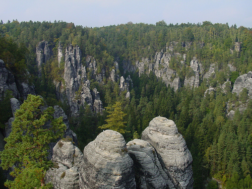
Saxon Switzerland National Park is a nature preserve in Saxony region of Eastern Germany. Saxon Switzerland National Park covers an area of 93.5 km2 picturesque forest and beautiful eroded sandstone formations. They were formed over a course of 100 million years and locally known as the "city in stone". There is web of hiking trails with a total length of 400 km or 250 miles, 50 km (31 mi) of biking paths and 755 climbing locations with a total of over 12,600 climbing routes.
Geography
The Saxon Switzerland National Park
is located - in two spatially separate areas - in the Saxon
Switzerland-Eastern Ore Mountains district.
Western area
This area includes the Bastei area, the Lilienstein and the
Polenztal. In the west the municipalities Stadt Wehlen and Lohmen,
in the north the municipalities Lohmen and Hohnstein, in the east
Hohnstein and Goßdorf and in the south the municipalities Bad
Schandau, Rathen and Stadt Wehlen delimit this area. The
municipality of Waitzdorf lies entirely in this area. Important
mountains are the Lilienstein 415 m above sea level, the bastion 305
m above sea level, the Hockstein and the fire 317 m above sea level.
The Grünbach flowing through the Amselgrund to the Elbe with the
Amselsee and the Polenz are the only notable bodies of water.
Eastern area
The eastern part includes the area of the
Schrammsteine, the Großer Winterberg, the Großer Zschandes and the
Upper Saxon Switzerland. In the west, the municipality of Bad
Schandau and the district of Altendorf and in the north the Sebnitz
districts of Altendorf, Ottendorf and Hinterhermsdorf limit this
area. In the east and south this area borders on the Bohemian
Switzerland National Park. From Schmilka to Bad Schandau, the Elbe
is the southern border of this area. Important mountains are the
Große Winterberg 556 m above sea level, the New Wildenstein with
Felsentor cowshed 337 m above sea level. and the Raumberg 459 m
above sea level. The Kirnitzsch is the only significant body of
water.
History
The first efforts to place Saxon
Switzerland under special protection began in the second half of the
19th century. Initially, only individual mountains, for example the
tied rock in the Rathen area, were protected by conservation
measures in 1850. The Polenz Valley was the first area to be
protected in 1912. Two associations, the Landesverein Sächsischer
Heimatschutz, founded in 1908 and the Association for the Protection
of Saxon Switzerland, founded in 1910, campaigned for nature
conservation until the Second World War. The idea of protecting
all of Saxon Switzerland emerged in the 1930s. The NSG Bastei (7.85
km²) was built in 1938 and the NSG Polenztal (0.91 km²) in 1940.
In 1953 efforts were made to proclaim a Saxon Switzerland
National Park. In 1954, this idea was presented to experts and state
authorities in Bad Schandau, but ultimately failed because of the
GDR government, which did not include the national park category in
the nature conservation law. A uniform landscape protection area of
Saxon Switzerland (368 km²) was created in 1956. From 1957
naturalists tried to set up an animal protection area with an area
of 35 km². The NSG Großer Winterberg was created in 1961 within
the landscape protection area. The NSG was expanded in 1966 to
include the Großer Zschand (NSG Großer Winterberg and Zschand) and
in 1986 to include the three sub-areas (Poblätzschwände,
Pechofenhörner and Raumberg) on 10.92 km². The NSG Kirnitzschklamm
(0.53 km²) was also proclaimed in 1961.
In addition to the
nature reserves, total reserves have been established. These are
areas that were not allowed to be entered. These areas were marked
with red, vertical hatching on hiking maps and marked in nature by
signs. When the NSG Kirnitzschklamm was founded, there was a total
reserve with an area of 0.22 km². In 1979 the total reserve Böses
Horn was established in the bear trap walls and in 1989 the total
reserves Auerhahnsteig and Weberschlueche. There were no national
parks in the GDR until 1990.
With the ordinance of September
12, 1990, Saxon Switzerland was converted into a national park, as a
result of which a uniform, internationally common and comparable
protected area was created.
Zoning
The core zones (natural dynamic zones)
in the national park enjoy special protection. In them nature is
left to itself; there are no more forestry interventions except
Limiting the mass reproduction of forest insects
Promotion of
single silver firs
Repulsion of alien, particularly expansive
tree species (such as white pine)
Preservation of particularly
striking visual relationships (viewpoints)
Removal and use of
trees for path maintenance in hard-to-reach areas
In the western
area of the national park, the core zone includes the bastion, the
Polenz valley and the fire area. In the eastern area there are the
Großer Winterberg, Großer Zschand and the Kirnitzschklamm. The
definition of natural dynamic zones is a prerequisite for the
national park to be recognized by the IUCN (World Conservation
Union) as a national park (protected area of category II according
to the IUCN system). According to the guidelines, at least 75% of
the area must be designated as a natural dynamic zone (core zone).
There are 4 types of zoning
Core zone (23% of the area of
the national park)
Nature zone A (37% of the area of the
national park), also known as a rest area or quiet zone. There is no
directing or utilizing intervention in nature to secure natural
processes. The natural zone A includes the core zone.
Natural
zone B (58% of the area of the national park), also known as the
development zone. There are only steering interventions in nature.
Maintenance zone (5% of the area of the national park) There is
permanent maintenance of the zone.
The core zone and nature zone
A form the basis as a category II protected area.
Natura 2000
ecological network
The national park is part of the European
ecological network Natura 2000. As a European bird sanctuary and FFH
area, the Saxon Switzerland National Park has been reported to the
EU Commission and legally secured with basic protection regulations.
The following are important subjects of protection:
Habitat types
Silicate rocks with crevice vegetation
Lichen-pine forests
Grove and woodruff beech forests
Mixed
ravine and hillside forests
Running waters with underwater
vegetation
Animal and plant species
Magnificent thin fern
Atlantic salmon, west group
Great mouse-eared bat, pug bat,
lesser horseshoe bat
Peregrine falcon, eagle owl, pygmy owl,
rough-owl, red-backed killer, black woodpecker, black stork
Climate
The climate in the national park shows extremes, which
can be explained by the strong structure of the landscape. The deep,
canyon-like gorges have a cool, humid basement climate. The reason
for this is the low solar radiation and the weak wind movement. On
the other hand, the rock reefs, some of which are free from
vegetation, are exposed to strong temperature fluctuations in the
summer months, up to 60 degrees between day and night, and strong
wind movements in the autumn and winter months. The average
temperature is 7 ° C and is higher in the Elbe Valley than in the
Upper Saxon Switzerland area. The annual amount of precipitation is
700–900 mm and is lowest in the Elbe Valley. Due to the drought,
there were 15 forest fires in Saxon Switzerland in the hot summer of
2018.
Ecology
Flora
Without forestry use, the area of
the national park would today largely consist of oak and hornbeam
forests. For about 200 years, this natural forest has been replaced
by spruce forest and is now slowly being converted back into a
natural deciduous forest. The strong structure of the landscape and
geological disturbances in the sandstone lead to special features in
the flora. Areas with previous volcanic activity are characterized
by a beech population. Typical for this is the area around the
Großer Winterberg, Raumberg and the armory exit from Goldstein to
Hinterhermsdorf. On the free-standing rock reefs, the reef pine
forests are dominant, some of which are similar to those on the
coast due to the action of wind. In the gorges there is an inversion
of the forest levels due to the cellar climate. Occasional silver
firs can be found on the slopes.
In the Kirnitzschtal between
the upper and lower lock and between the Neumannmühle and Bad
Schandau, small meadows have formed. The ground vegetation, if any,
consists of heather, ferns and bilberry. As further plants in the
ground area, the swamp porst and the Fuchs's ragwort should be
mentioned. On moist rock surfaces (layer joints, mouth hole areas of
caves), luminous moss, well adapted to the lowest light availability
and acidic water, grows all year round.
Hemp is the host
plant of the endoparasitic mushroom Uredo kriegeriana, which has so
far only been found in Saxon Switzerland. Alien plants are the
glandular balsam and the white pine.
Fauna
Due to the large closed forest area in the eastern
part of the national park and the adjacent area in the Bohemian
Switzerland National Park, which are almost uninhabited, a large
number of rare animal species have found a retreat here and
populations that have already died have been successfully resettled.
Birds: owls, hawks, black stork, kingfisher, all woodpecker
species
Mammals: 16 of 18 bat species native to Germany, wild
boar, red deer, martens, lynxes
Reptiles: adder, grass snake,
fire salamander
Fish: trout, salmon
Successful resettlements
The peregrine falcon disappeared completely in the 1970s and has
been reintroduced since the early 1990s. There is currently a stable
population. For their successful expansion, nest protection zones
are set up during the breeding and rearing season (March to August).
The wild boar was exterminated at the beginning of the 19th century,
but has been resettling without human intervention since the 1950s
and today represents a strong, harmful population. Chamois were
released from 1907 to 1911 and 1937 to 1939, and their descendants
are still a stable population today form. The same applies to the
naturalization of mouflons since the 1930s. Despite several
proposals to reintroduce the capercaillie, which has not been
detected since the 1970s, a population of this bird is still missing
in the national park. The last lynx was hunted in 1743. The lynx
stone in the Lindengründel is a reminder of this. There are still no
confirmed sightings of a lynx in the wild; it is suspected on the
basis of faeces, tracks and torn game that a small lynx population
has settled again in the meantime.
Tourism
Hike
The
development of the road network in today's national park took place
in the first half of the 19th century and was completed at the
beginning of the 20th century. It is shown in full in historical
route guides (e.g. Meinhold's route guide). As early as the 1980s,
the first closures (Gratweg Thorwalder walls) and the designation of
total reservations that were no longer allowed to be entered. Today
the national park has a marked network of 400 km of trails, numerous
mountain restaurants and a network of 50 km of cycle paths. Roads
are compulsory in the National Park. Outside the core zone, all
paths may be used, inside the core zone only marked paths. The
marking is carried out according to the following gradation.
Main hiking trails - well-developed hiking trails: white square with
a colored line or circle with the following color meaning
blue -
national route
red - regional route
green and yellow - local
way
Mountain path - paths that are only minimally developed and
require surefootedness and, in some cases, a head for heights: gray
rectangle with green triangle, the tip of which points in the
direction of the path.
Mountaineering access - only to be used by
mountaineers as access to climbing peaks: White circle with black
triangle, the tip of which points in the direction of the path, and
black circumference
Closed path: white circle with black cross
and black perimeter around the cross
There are also the
following special markings.
Educational trails (e.g.
Flößersteig): white square with green diagonal line
European
long-distance hiking trail E3: white square with blue E3
Malerweg
- historical hiking trail: white square with a stylized M
The
International Mountain Hiking Trail of Friendship Eisenach-Budapest
(EB) is now integrated into the European hiking trail E3.
Path concept
Almost all the climbing facilities were preserved
until the beginning of the 1990s and enabled hikes on the historical
network of trails. In 2000 a path commission was formed, which
consisted of representatives from the following institutions.
National Park Administration
Saxon Switzerland Tourism
Association
Saxon Mountaineering Association
Parishes in
National Park
Conservation associations
Saxon State Ministry
for Energy, Climate Protection, Environment and Agriculture (SMUL)
The result of the meetings in 2000 was the draft of a route
concept, which was published on February 29, 2001 by the SMUL as an
announcement. This meant that some historical and, in some cases,
monument protection paths were no longer part of the official
network of paths.
Foreign path or border path between the Gr.
Winterberg and the Prebischtor (formerly the classic crossing of
Saxon-Bohemian Switzerland)
upper part of the hiking trail
through the Gr. Zschand to Rainwiese (Mezní Louka) from the
Hickelschl Bäumen junction
Hiking trail from the Weber grotto
through the Partschenhörner to the connection to the Gabrielensteig
on the Bohemian side
Hiking trail from the Altarstein through the
Ziegengrund to Hinterdittersbach
Meandering path in the Großer
Winterberg area - Pascherweg (state border) below the Silberwand
(Stříbrné stěny) - Heuweg to Hřensko (Herrnskretschen)
Entenpfützenweg between Großer Zschand and Fremdweg
The trail commission meets once a year on issues related to
hiking tourism in the national park. The path concept has not led to
a sufficient overall reduction in hiking tourism, but to a sewer
system for hiking tourism. The national park administration tries to
enforce the closures by patrols with national park rangers and
making impassable paths (targeted tree felling) that are no longer
part of the official hiking network.
The problem of the
border route is currently unsolved. The Grenzweg is a hiking trail
between Grosser Winterberg and Grosser Zschand along the
German-Czech border, which is partly identical to the tourist trail.
So far, no agreement has been found between the Bohemian and Saxon
National Park administrations, not even about parts of the route.
Even if the border may be crossed at any point after the accession
of the Czech Republic to the Schengen Agreement, this is not
permitted in the area of the eastern core zone.
Rockclimbing
The technical development began in the second half
of the 19th century and continues to this day in terms of new
climbing routes. There are 1,147 climbing peaks with over 15,000
climbing routes in the national park area. Various climbing peaks
are subject to temporary closures for nature conservation reasons
(breeding season). You can only climb according to the Saxon
climbing rules.
Cycle
A good 50 kilometers of path network
are officially designated for bicycle traffic. They connect the
national Elbe cycle path and the Bohemian cycle path network. Most
of the paths are not asphalted and are used by hikers who have
priority throughout the national park. Various bicycle buses bring
you directly to the starting points. The national park
administration strongly advises against cycling at dusk, as the wild
animals living here are particularly sensitive to interference at
this time.
Problems
An evaluation completed in April 2012
as part of the overall evaluation of the German National Parks came
to a critical conclusion with regard to compliance with the quality
criteria and standards for German national parks in the Saxon
Switzerland National Park.
In particular, the following
problems were named:
The 75% wilderness goal (the achievement of
which is also a prerequisite for international recognition of the
national park) is only to be achieved 43 years after it was founded
in 2033.
The actual process protection area, on which no human
intervention takes place, is very much fragmented. As a result of
forest roads, hiking trails, mountain paths and access routes to
climbing rocks, these areas show an extraordinarily high degree of
fragmentation with a corresponding potential for impairment by
visitors. In addition, there is strong (over) tourist use. In
addition, game was hunted almost across the board, so that a “strict
nature zone without management” according to international standards
practically does not exist. So far there is no concept for further
reducing the extraordinarily high density of roads.
High
proportion of spruce forests that are not appropriate to the
location with an overall still below average degree of closeness to
nature.
Too little rangers lead to inadequate visitor information
and area control.
In addition, the national park has been
suffering from bark beetle infestations for several years. The
national park administration is not actively taking action against
this, which means that the forest can be converted into natural
mixed forest in the long term.
UNESCO World Natural Heritage
On May 10, 2004, the district council of the Saxon Switzerland
district decided to nominate parts of Saxon Switzerland as a UNESCO
World Heritage Site. The cities and municipalities concerned
subsequently decided to support the nomination. Since the Elbe
Sandstone Mountains cross borders, decisions were also made on the
Czech side to nominate Bohemian Switzerland as a World Heritage
Site. On June 30, 2005, the mayor of Děčín, the district
administrator of the Saxon Switzerland district and the Saxon
Switzerland tourism association signed a cooperation agreement.
On behalf of the district, the Freiberg company GEOmontan
prepared a potential analysis that characterizes Saxon-Bohemian
Switzerland as a unique example of geological changes. The study was
presented to invited guests on February 22nd, 2006 at the
Pirna-Copitz vocational school center.
This endeavor is
currently little noticed by the public. The event about the loss of
the title of the nearby world cultural heritage Dresden Elbe Valley
due to the construction of the Waldschlößchenbrücke superimposed the
efforts of the Saxon Switzerland-Eastern Ore Mountains and Děčín
districts.