Area: 4410 km ²
Schleswig-Holstein Wadden Sea National Park (Nationalpark
Schleswig-Holsteinisches Wattenmeer) is Germany's largest national
park and part of the UNESCO World Heritage-listed Wadden Sea, the
world's largest continuous intertidal sand and mudflat system. It
stretches along the North Sea coast of Schleswig-Holstein from the
Danish border in the north to the Elbe estuary in the south,
covering about 4,410 km² (much of it underwater or tidal flats).
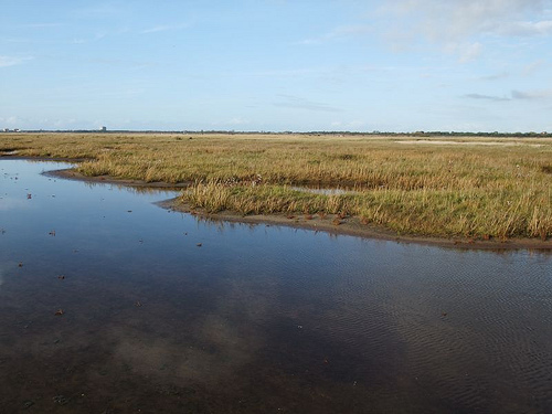
This dynamic landscape features vast mudflats exposed at low tide,
salt marshes, sand dunes, beaches, tidal creeks, and the unique
Halligen (low-lying islands without dikes that flood during storms).
It is a critical habitat for seals, porpoises, millions of migratory
birds, and diverse marine life like lugworms, mussels, and starfish.
Best Time to Visit
Spring (March–May): Excellent for birdwatching
during migrations; milder weather and blooming salt marshes.
Summer
(June–August): Warmest for mudflat walks, swimming, and boat trips
(12–20°C / 54–68°F). Long daylight hours, but can be crowded and windy.
Peak season July–August.
Autumn (August–October): Great for
birdwatching (autumn migration) and fewer crowds. Still good for walks.
Winter: Quieter, with potential for dramatic storms, but cold, windy,
foggy, and fewer services/guides.
Shoulder seasons (late May or early
September) often balance weather, crowds, and costs best.
Tides
dictate everything—always check local tide tables (apps or visitor
centers) as mudflats flood quickly.
How to Get There
By car:
Most flexible. From Hamburg, it's about 1.5–2 hours to key spots like
Husum, Tönning, or St. Peter-Ording. Major roads connect coastal areas.
By train: Good access via Husum (northern hub) or other coastal towns.
From Hamburg, trains reach Husum then connect to places like Bad St.
Peter Süd.
Ferries: Essential for islands (e.g., Sylt, Amrum, Föhr)
and Halligen from ports like Dagebüll, Schlüttsiel, or Nordstrand.
Air: Nearest major airport is Hamburg (HAM); smaller options like Sylt.
Base towns:
Tönning or Husum (central, near visitor centers).
St. Peter-Ording (beaches, dunes).
Büsum (harbor, seal tours).
Islands like Amrum or Föhr for immersion.
Must-Do Activities
Guided Mudflat Hiking (Wattwanderung): The signature experience. Walk on
the exposed seabed at low tide with a certified National Park guide.
Discover lugworms, mussels, starfish, crabs, and more. Tours last 1.5–4+
hours; go barefoot or wear sturdy boots/old shoes. Never go alone—tides
are dangerous.
Seal and Wildlife Spotting: Boat tours from various
harbors to sandbanks for harbour/grey seals. Visit Seehundstation
Friedrichskoog for rescued seals.
Birdwatching: Over 10,000 ha of
salt marshes and flats support vast flocks, especially during
migrations. Bring binoculars.
Boat Trips and Halligen Visits: Explore
inhabited Halligen (e.g., Hooge) or remote ones. Some offer unique
mudflat walks to emerging sandbanks.
Cycling and Hiking on Dikes/Salt
Marshes: Flat, scenic paths with views. Bike rentals common.
Visitor
Centers:
Multimar Wattforum in Tönning: Main center with aquariums,
interactive exhibits on whales, tides, and ecosystem. Open year-round.
Others on Sylt or smaller info points.
Practical Visiting Tips
Safety First: Tides rise fast (up to 3.7m range in places). Stick to
guided tours in the flats. Check weather/tides. Dress in layers—windy
and changeable. Waterproof jacket, sun protection, and quick-dry clothes
essential.
What to Wear/Bring: Old shoes or go barefoot for mud (it
can suck shoes off). Binoculars, camera, water, snacks, insect repellent
(summer). No need for fancy gear.
Rules and Protection Zones:
Zone
1 (core): Mostly closed; guided access only in allowed areas. Zero-use
zones in sensitive spots.
Zone 2 (buffer): More activities allowed
(swimming, sailing, traditional fishing).
Stay on paths, don't
disturb wildlife/seals/birds, no collecting (except limited in some
tours), no drones/jet skis in sensitive areas. Dogs often restricted.
Costs: Park entry is free. Guided tours €10–30/person. Ferries and
accommodations add up. Visitor centers often low/no cost.
Accessibility: Flat terrain helps, but mudflats are uneven/muddy. Some
centers and paths are accessible; check specifics.
Sustainability:
Support certified National Park partners/guides. Local seafood (mussels,
shrimp) but respect sustainable practices.
Weather Prep: North Sea is
unpredictable—rain possible anytime. Wind chill makes it feel colder.
Accommodations and Practicalities
Options range from campsites,
holiday apartments, and hotels in coastal towns to unique stays on
Halligen or islands.
Book ahead in summer. Many places offer tide
info and tour bookings.
Eat fresh seafood, try Krabben (shrimp) or
local specialties. Towns have good restaurants.
Additional
Highlights
North Frisian Islands (Sylt, Amrum, Föhr): Beaches, dunes,
charming villages (some accessible without ferries via causeway to
Sylt).
St. Peter-Ording: Long sandy beach and pier.
Combine with
nearby Denmark for a cross-border Wadden experience.
The national park covers the
Schleswig-Holstein coastal area of the North Sea from the Danish border
in the north to the mouth of the Elbe in the south. In the northern area
(up to around Amrum) the national park border runs along the twelve-mile
line, south of it around the three-mile line. On the land side, it runs
150 meters off the coast in the Wadden Sea. Sea dikes and the immediate
forelands of the dikes are not part of the national park, and bathing
beaches are also largely excluded from the protected area. The inhabited
areas in the sea are also excluded from the national park, including the
five German North Frisian islands and the large Halligen islands:
Langeneß, Hooge, Gröde, Oland and Nordstrandischmoor. Part of the
national park are uninhabited islands, Halligen and sandbanks such as
Trien, Blauort or the North Frisian outer sands. According to the
classification of Germany's main natural spatial units, the area of the
national park belongs to the "Schleswig-Holstein Wadden Sea, Islands and
Halligen" unit in the Schleswig-Holstein Marshes group and to the main
unit German Bight.
The national park can be divided into two
areas. In the north between the Danish border and the Eiderstedt
peninsula is the North Frisian part, on the south coast of Eiderstedt up
to the mouth of the Elbe is the Dithmarscher part. The North Frisian
Wadden Sea belongs together with the Danish Wadden Sea to the northern
Wadden Sea of the North Sea. It is shielded from the open sea by the
North Frisian islands and Halligen. The islands were mainly formed from
mainland areas that were separated from the land due to catastrophic
floods. The Wadden area is more sheltered, the transition between the
Wadden Sea and the sea is often clearer, since the first is on the east
side of the large islands, the second on the west side. There are no
large estuaries, and the tide difference is relatively small at less
than two meters. Geest cliffs from the Ice Age can only be found in the
northern Wadden Sea, so that the greatest differences in height also
occur here on the coasts in what is actually a very flat area. The
Dithmarscher part and the south coast of Eiderstedt between the Elbe and
Eider estuaries form part of the central Wadden Sea. A tidal range of
more than three meters largely prevents the formation of islands. A few
sandbanks rise out of the sea, only Trien is high enough, and thus safe
from storm surges, to allow vegetation that is sensitive to salt water.
In comparison to the geologically similar East Frisian Islands of the
southern Wadden Sea, however, Trisch is much smaller and younger. All
attempts by human residents to fortify the island have failed. Due to
several large estuaries, the salinity in the central Wadden Sea is lower
than in the rest of the Wadden Sea and is subject to greater
fluctuations.
The
national park is divided into two zones that correspond to different
levels of protection. Zone 1 forms the core of the protected area. The
162,000 ha zone covers a good third of the national park. It consists of
twelve larger spatial units, each of which has salt marshes, silt, mixed
and sandy tidal flats, flat and deep areas that are permanently under
water (sublitoral) and tidal creeks. In addition, there are smaller
units around particularly sensitive areas such as seal banks or the
breeding colonies of seabird species, places where many migratory birds
moult, as well as geomorphologically significant areas with almost
natural surface structures. Zone 1 is basically closed to the public,
the only exceptions are mudflat areas directly adjacent to the coast for
mudflat hikers, routes for guided mudflat hikes and fishing. To the
south of the Hindenburgdamm on the land side of Sylt, human use is
completely excluded within protection zone 1 ("zero use zone"). This
occupies 12,500 ha, of which about 3,500 ha are permanently covered by
water.
Zone 2 forms a so-called "buffer zone" around zone 1, in
which sustainable use is made possible. In protection zone 2 is the
small whale protection area west of the Sylt coast, which has a size of
124,000 hectares. This area is an important breeding area for harbor
porpoises, whose population in the North Sea has declined by 90% in the
20th century. While uses such as bathing, sailing or traditional shrimp
fishing are still possible in the area, it is intended to prevent
international industrial and gillnet fishing, jet skis, ship speeds
exceeding twelve knots, military activities and resource exploitation
(sand, gravel, gas or oil).
The North Sea coast is flat; the sea
floor drops only a few centimeters per kilometer. Twice a day the tide
carries sand, clay and silt into the Wadden Sea area. The tidal range in
the Schleswig-Holstein Wadden Sea is between 1.5 and 3.7 meters,
increasing from north to south: the lowest tidal differences are on the
north coast of Sylt, the highest in southern Dithmarschen. Everywhere in
the Wadden Sea, the time it takes for the water to flow is only about
85% of the time it takes for the water to run off again. The current is
therefore stronger when the water rises, and the ebb does not have the
strength to carry away the sediments washed up by the tide.
More
than two thirds of the area of the national park are occupied by areas
that are constantly under water (sublittoral), 30% of the mud flats that
are dry at low tide and flooded at high tide (eulittoral). The rest are
land areas (supralitoral) that are only submerged under special
circumstances. The water areas consist on the one hand of the seaward
part of the park, on the other hand of larger tidal currents such as the
Lister Deep, the Heverstrom, the Purrenstrom, the Wesselburener Loch or
the Piep. Directly in front of the Wadden Sea there is a constant strong
current from south to north, coming from the southern North Sea and
continuing to the Norwegian Channel. Since the current carries the
estuary waters of large European rivers such as the Rhine or Elbe, the
salinity is 20-30 psu below that of the sea, but still above that of
estuaries.
Since inhabited areas are not part of the national
park, the land areas consist almost entirely of salt marshes, with a
small remainder of sandbars and dunes. The salt marshes cover an area of
over 10,000 hectares, of which 70% were formed on the mainland in the
protection of tallows, 10% are on the leeward sides of the islands and
the rest have formed around the Halligen. Between 1988 and 2001, the
area of the salt marshes expanded by around 700 ha. Largely natural,
unused salt marshes are mainly found off the islands; on the mainland,
this only occurs off Schobüll and Sankt Peter-Ording.
As in the
entire Wadden Sea, the climate is Atlantic, always humid and warm
temperate. Strong westerly wind drift and the heat storage capacity are
determining factors, which ensure frequent strong winds, but have a
balancing effect on the temperatures, so that the area enjoys cool
summers (July: 14.5 °C) and mild winters (January: 1.8 °C). learns.
Schleswig-Holstein Wadden Sea National Park (Nationalpark
Schleswig-Holsteinisches Wattenmeer) is Germany's largest national park,
covering about 4,410 km² (roughly 4,380 km² in some sources). It forms
the northern German section of the UNESCO World Heritage-listed Wadden
Sea, stretching from the Danish border in the north to the Elbe estuary
in the south.
This park protects one of the world's largest
continuous intertidal systems of sand and mudflats. It features diverse
habitats including extensive tidal flats (eulittoral), permanently
submerged areas (sublittoral), salt marshes, sandbanks, tidal creeks,
seagrass meadows, and limited dunes. About 68% of the area is
underwater, 30% consists of intertidal flats exposed at low tide, and
the rest includes supralittoral land like salt marshes.
The park's
dynamic environment—shaped by tides (1.5–3.7 m range), salinity
gradients, strong winds, and sediment deposition—supports high
biodiversity despite harsh conditions. Estimates indicate around 700
plant species and 2,500–3,200 animal species in the Schleswig-Holstein
section, with about 10% endemic or highly specialized. Salt marshes
alone host around 2,300 species of flora and fauna combined, while
marine/brackish areas add another ~2,700.
Flora (Plants)
The
flora is highly adapted to tidal flooding, high salinity, and
nutrient-rich but oxygen-poor sediments.
Seagrass Meadows: Eelgrass
(Zostera marina) is the only true flowering plant that lives fully
submerged. It covers significant areas (up to ~6,000 ha, especially in
the northern part), providing critical habitat and food. Stocks here are
relatively stable or increasing compared to global declines.
Salt
Marshes: These dominate the vegetated land areas (>10,000 ha). They form
zoned communities based on flooding frequency and salinity:
Pioneer/Low Marsh (frequently flooded): Glassworts (Salicornia spp.),
Spartina anglica (invasive cordgrass, now widespread and important for
sediment stabilization), common saltmarsh-grass (Puccinellia maritima),
sea-blite (Suaeda maritima), sea-purslane (Halimione portulacoides), and
sea aster.
Mid-to-High Marsh (less flooded): Sea plantain (Plantago
maritima), sea lavender (Limonium vulgare), red fescue, sea wormwood,
and others like seaside centaury (Centaurium littorale), red eyebright
(Odontites rubra), and sedges. About 40–50 highly specialized flowering
plant species thrive here.
Other Habitats: Limited dunes and dune
valleys support marsh-like plants such as cotton grass (Eriophorum
angustifolium), sundews (Drosera), and marsh gentian. Mudflats feature
microscopic algae and diatoms that form the base of the food web.
Salt marshes act as nurseries and buffers, with vegetation trapping
sediment and supporting invertebrates. Grazing (e.g., by sheep)
influences succession and diversity.
Fauna (Animals)
The
Wadden Sea's high biomass productivity supports vast numbers of
invertebrates, fish, birds, and mammals. It serves as a nursery, feeding
ground, and migration hub.
Invertebrates (Foundation of the
Ecosystem)
Mudflats: Lugworms (Arenicola marina) create
characteristic casts and aerate sediment; they are iconic. Common
cockles (Cerastoderma edule), blue mussels (Mytilus edulis), sand
gapers, shrimp (Crangon crangon), shore crabs (Carcinus maenas), and
barnacles are abundant. Up to 100,000 tiny mud snails per square meter
in places.
Salt Marshes: ~1,800–2,000 specialized insect and spider
species, many endemic. Examples include weevils specific to sea lavender
and the magnificent salt beetle (Bledius spectabilis).
These
organisms process organic matter and feed higher trophic levels.
Fish
Over 60–140 species recorded (many visitors from the North Sea).
The area is a crucial nursery for plaice, sole, herring, and other
flatfish. Resident or common species include eelpout (Zoarces
viviparus), sand goby, sea scorpion, garfish, and others. Larger species
like sturgeon (historically) and rays also occur.
Birds
The
park is one of Europe's most important bird areas. It supports 10–12
million migratory birds annually (part of the East Atlantic Flyway),
with peaks of millions present simultaneously. About 100,000 breeding
pairs.
Key Groups: Waders (oystercatchers, redshanks, curlews,
avocets, ringed plovers), ducks (shelducks, eiders, common scoters),
geese (barnacle geese ~60,000, brent geese), gulls, terns (including
Arctic terns), and others.
Notable: The northwest-European shelduck
population (majority) molts here, especially around Trischen island.
Large barnacle goose and eider colonies on islands and Halligen.
White-tailed eagles have returned as breeders.
Marine Mammals
Harbour Seals (Phoca vitulina): ~13,000 in the Schleswig-Holstein
section (part of a recovering Wadden Sea population of tens of
thousands). They haul out on sandbanks to rest and pup.
Grey Seals
(Halichoerus grypus): Smaller numbers (~140–200), mainly on specific
sandbanks near Amrum.
Harbour Porpoises (Phocoena phocoena): One of
the smallest whales; significant populations, especially in a dedicated
protection zone west of Sylt and Amrum (important calving/nursing area).
"Big Five," "Small Five," and "Flying Five"
Popular interpretive
frameworks highlight charismatic species:
Big Five: Harbour porpoise,
grey seal, common seal, European sturgeon (rare), white-tailed eagle.
Small Five: Typical mudflat creatures like lugworm, cockle, shrimp,
crab, and mud snail (encountered on guided walks).
Flying Five:
Iconic birds like shelduck, barnacle goose, etc.