Location: Stecklenberg, Saxony- Anhalt Map
Constructed: 12th century
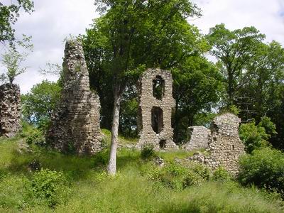
Ruins of medieval Stecklenburg
Castle are located near Stecklenberg, Saxony- Anhalt region of Germany.
It was constructed in 12th century.
Early History and Construction (11th–12th Centuries)
The medieval
castle was likely initiated under the influence of the Bishopric of
Halberstadt or as an aristocratic residence. The first indirect mention
comes in 1129, when a noble named Gero de Steckelenberge (or Gero de
Steckeleberge) is documented; he took his name from the site, though the
castle itself is not yet named. From the 12th century onward, the
complex stood under the feudal overlordship (Lehenshoheit) of the
Quedlinburg Abbey (Stift Quedlinburg).
The castle was first
explicitly documented in 1281 as castrum Steckelenbork (or
Steckelenborgk), now clearly owned by the Halberstadt Abbey (Stift
Halberstadt). The bishops of Halberstadt had it rebuilt and expanded. By
the late 12th century, the southwestern outer bailey (Vorburg) was
developed into the main castle area, featuring a small rounded
Romanesque core (Kernburg, ~40 m diameter) with a round tower (~6 m
diameter), a square keep (Bergfried, base ~9 × 9 m), palas (residential
building), chapel, and ring walls. The entire site was protected by wide
ditches on three sides.
Ownership, Feuds, and 14th–17th Centuries
In 1311, the castle passed as a fief (Lehen) to the Ritter von Hoym
(Knights of Hoym) family, who held it (with interruptions) until the
early 17th or early 18th century. It was referred to in 1333 as hus zu
deme Sthekelnbergehe. A major destruction occurred in 1364 (cause
unclear but likely tied to regional conflicts), followed by immediate
rebuilding.
The von Hoym family used it as a residence and economic
center, with associated lands, villages, and operations extending to
Neinstedt below. Regional feuds were common, including documented
tensions with Quedlinburg Abbey. During the Thirty Years’ War
(1618–1648), the castle remained defensible and was still partially
occupied and functional into the early 18th century.
Decline and
Dismantling (18th–19th Centuries)
By 1713, the von Hoym family sold
the castle and its estates to the King of Prussia, who converted the
surrounding lands into a Prussian domain (Domäne). The village of
Stecklenberg itself was largely founded in the late 18th century by
settlers for these agricultural operations.
Occupation dwindled: the
site was still partially inhabited until around 1736, but by ~1750 it
was largely abandoned. Systematic demolition followed—the chapel and
brewery were torn down (stones reused for a new village church and other
buildings), and the complex was quarried for building material. The keep
collapsed or was deliberately demolished around 1834–1839 due to alleged
structural instability.
Preservation and Modern Era
Complete
destruction was averted when the senior forester (Oberförster) of Thale
objected and secured protected-monument status. He personally oversaw
early conservation efforts. Today, the ruins are a protected cultural
monument and popular hiking destination. Visible remains include
sections of the living-quarters walls (Palas), the keep stump, cellar
vaults, outer walls, and traces of the older rampart. The site evokes
the medieval Harz landscape and is freely accessible.
Construction Phases and Architectural Evolution
Stecklenburg
exemplifies multi-phase medieval castle development in central Germany,
evolving from early Romanesque forms to more standardized late-medieval
layouts under noble and later ecclesiastical ownership.
11th–Early 12th Century (Romanesque Core – Kernburg): Built around
1000–1100 CE by the Ritter von Stecklenberg (Stackelberg family) on the
older ringwall. The small, rounded/oval-shaped inner bailey (Kernburg)
at the northern tip measures about 40 m in diameter. Its curved walls
provided better resistance to siege weapons and projectiles than
straight ones—a hallmark of early Romanesque defensive design in the
Harz region. A small round tower (Rundturm or early Bergfried) survives
in remnants, roughly 6 m in diameter; round towers were less common than
square ones but appear in some early stone fortifications influenced by
regional or crusade-era ideas.
12th Century and Later Expansions: The
castle was destroyed in battle during the 12th century but quickly
rebuilt. By the late 12th century, the southwestern outer bailey
(Vorburg) was expanded and converted into the main bailey (Hauptburg).
Ownership passed to the Halberstadt abbey (Stift Halberstadt) in 1281,
after which further modifications occurred. Key additions included a
square-plan Bergfried (keep), a late-medieval Palas (residential hall),
ring walls, and a chapel.
The castle remained occupied until the
early 18th century. Structures like the brewery (Brauhaus) and chapel
(Burgkapelle) were then dismantled and relocated to the village below.
By the mid-18th century it served as a quarry until local intervention
(by the senior forester of Thale) preserved it as a protected monument
around 1850.
Key Architectural Features
Defensive Elements:
Natural steep slopes and wide ditches/moats on three sides formed the
primary defense. Surviving or documented features include curtain walls
(Ringmauer) and ramparts from both the older Burgwall and medieval
phases. The layout separated a core bailey from outer areas for layered
defense.
Bergfried (Keep): The later square keep measured
approximately 9 × 9 m at the base with walls up to 2 m thick—typical for
a combined residential/defensive tower in Harz castles. The original
round tower in the Kernburg complemented this. The square keep largely
collapsed in the 19th century.
Palas and Residential Buildings: The
late-medieval Palas served as the main living quarters for the nobility
or administrators. Ruins include wall fragments and gable ends of
residential structures. Foundations, cellars, and vaults also remain
visible.
Other Structures: A castle chapel (demolished 1750) and
ancillary buildings (e.g., brewery) once existed but are gone. The
overall design was functional rather than ornate—focused on defense,
residency, and administration for a smaller noble/ecclesiastical fief
rather than a grand princely seat.
Materials and Construction: Local
Harz stone masonry (rubble stone or roughly hewn blocks bound with
mortar), typical of regional castles. No elaborate decorative elements
(e.g., Gothic tracery or Renaissance details) survive due to the extent
of ruin and quarrying.
Current State of the Ruins
Today,
Stecklenburg is a protected cultural monument and popular hiking
destination offering panoramic views. Visible remains are modest but
evocative:
Fragments of residential building walls and gable
ends.
Bases and partial remnants of the keeps (both round and
square).
Sections of curtain walls and earthworks from the older
ringwall.
Foundation traces, cellars, and vaults.
The ruins
convey the castle’s original compact, topography-adapted layout without
extensive reconstruction. A detailed scale model of the castle stands in
Stecklenberg village, helping visitors visualize its former appearance.
Nearby (a few hundred meters uphill) are the larger, better-preserved
ruins of Lauenburg Castle, which share the same strategic ridge and
offer a comparative view of Harz medieval fortifications.
Architectural and Historical Significance
Stecklenburg represents a
classic smaller Höhenburg in the Harz: pragmatic, multi-phase stone
construction blending prehistoric ramparts with Romanesque rounded forms
and later medieval standardization. Its evolution—from family seat to
ecclesiastical stronghold—mirrors broader shifts in medieval power
structures in central Germany. Though heavily reduced by time,
quarrying, and decay, the surviving walls and earthworks provide clear
evidence of defensive innovation, residential function, and adaptation
to a rugged landscape. It remains a quiet but rewarding site for
understanding everyday medieval castle life rather than the more famous,
heavily restored examples elsewhere in the Harz.
Key Attractions
Stecklenburg Castle Ruins (Burg Stecklenburg): The
main draw — medieval ruins perched on a hill with panoramic views over
the surrounding Harz landscape. Explore the remnants, including walls
and towers. It's a short, rewarding hike from the village. Nearby is the
Lauenburg Castle ruins, another historic site.
Glockenstein: A
prehistoric granite boulder shaped like a bell, believed to have been an
ancient Germanic cult site. It's part of the popular Harzer Wandernadel
hiking stamp system (checkpoint 73).
Surrounding Nature: Stecklenberg
lies near the Bode Valley (Bodetal), Teufelsmauer (Devil's Wall) rock
formations, Hexentanzplatz (Witches' Dance Floor), and Rosstrappe. These
spots feature legends of witches and dramatic cliffs.
Visiting
Tips
Best Time to Visit: Late spring to autumn (May–October) for
hiking and pleasant weather. Summers can be busy on weekends with German
tourists. Winters bring snow and potential trail closures, but the Harz
has a magical, fairy-tale feel then (good for Christmas markets nearby).
Getting There:
By Car: Easiest option. Drive via the A36 or B6 from
major cities like Magdeburg (~1 hour), Halle, or Quedlinburg (~20-30
minutes). Parking is available near trailheads.
Public Transport:
Train to Thale station, then bus or taxi (~5-10 minutes) to
Stecklenberg. The Harz region has good but not frequent connections.
From Berlin: About 2.5–3 hours by car or train + transfer.
Hiking
& Outdoor Activities (Highly Recommended):
Easy to moderate trails
around Stecklenberg, including a circular route past the castle ruins
and Lauenburg (~4.5 km, 1–2 hours).
Connect to the Hexenstieg
(Witches' Trail) or Bode Valley paths for deeper exploration.
Harzer
Wandernadel system: Collect stamps at checkpoints for a fun goal.
Nearby: Chairlift or gondola to Hexentanzplatz/Rosstrappe for views and
a toboggan run (HarzBob).
Duration: Half a day for the village
and ruins; 1–3 days if combining with Thale and Harz highlights. It's
perfect as a side trip from Quedlinburg (UNESCO old town, ~20-30 min
away).
Practical Tips
Accommodation: Limited in tiny
Stecklenberg itself — look for guesthouses or the Schlosshotel
Stecklenberg area. Better options in Thale or Quedlinburg (hotels,
holiday apartments). Book ahead in peak season.
Food & Drink: Few
options in the village — try local Harz specialties like game dishes,
potatoes, or regional beers. Head to Thale for more restaurants. Picnic
on hikes is common.
Language & Services: German is primary; English
is limited outside tourist hubs. Cash is useful in smaller places.
Tourist info in Thale.
What to Bring: Sturdy hiking shoes (trails can
be rocky/muddy), rain jacket (Harz weather changes fast), binoculars for
views, and the Harz Card if doing multiple attractions (discounts on
lifts, museums, transport).
Family/Kids: Good for ages 6+ who enjoy
hiking and ruins. Nearby funpark, mini-golf, and toboggan add appeal.
Nearby Must-See Spots (Day Trips)
Thale — Cable cars, Bode Valley
hikes, Hexentanzplatz.
Quedlinburg — Stunning half-timbered old town
(UNESCO).
Wernigerode — Picturesque town and castle.
Brocken —
Harz's highest peak (train or hike).
Harz National Park for deeper
nature immersion.