Location: Mecklenburg-Vorpommern Map
Area: 318 km2 (123 sq mi)
Tel. +49 3991 668849
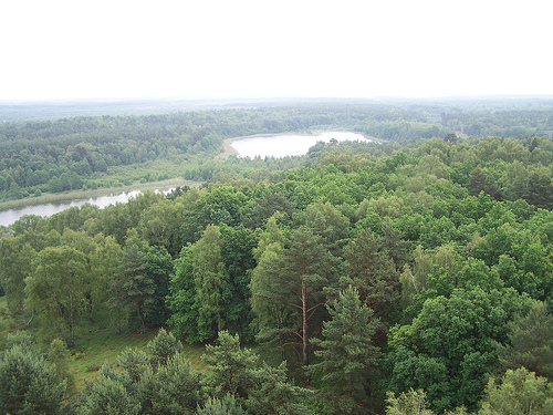
Müritz National Park is located in the South region of Mecklenburg-Vorpommern region of Germany. Müritz National Park reserve covers an area of 318 km2 (123 sq mi). Visitor center is situated in the small town of Müritzeum. Over 65% of the nature preserve is covered by forests and small meadows, while another 12% are covered by over 130 lakes, rivers and small creeks. The rest of the park is covered by marshes, swamps and bogs. These are mostly inaccessible to the public unless you feel dangerous or stupid. Swampy area is fairly dangerous especially if you travel alone. In general it is not wise to stray off the network of trails that covers over 660 km in length.
The national park, which covers
a total of 322 km², is 72 percent covered by forests and 13 percent
by lakes; eight percent of the area are moors and five percent
meadows and two percent arable land.
The Vistula Ice Age
shaped the landscape around 15,000 years ago. The glacier masses of
the Pomeranian main terminal moraine left boulders, tongue pools,
gullies and countless dead ice holes. The latter are now scattered
all over the landscape as lakes (for example the Wienpietschseen)
and Sölle.
In total, there are 108 lakes with more than one
hectare and countless smaller still waters in the national park.
With an area of 117 square kilometers, the Müritz is the largest
body of water that lies entirely within Germany.
The Müritz sub-area mainly comprises the eastern
hinterland of the Müritz. Besides the Müritz, which is only partly
in the national park, larger bodies of water in the western part are
the Feisnecksee, Rederangsee, Specker See and Woterfitzsee. Some
lakes on the east bank of the Müritz were at times part of the
Müritz due to fluctuations in the water level caused by mill dams
and the regulation of the Elde.
The highest elevation in the
generally flatter Müritz part is the Käflingsberg at 100.3 m above
sea level. NHN. Here is the Käflingsberg tower, a combined
observation tower, fire station and mobile radio transmission tower.
The Serrahn sub-area comprises the eastern
part of the national park and is located in the transition between
the Mecklenburg Lake District and the Feldberg Lake District. In the
densely wooded, hilly part of the national park there are larger
lakes with the Großer Fürstenseer See, the Schweingartensee and the
Zwirnsee. However, they are not as characteristic of the landscape
as in the western part. The Serrahn sub-area is enclosed by the
Feldberger Seenlandschaft nature park.
In the Serrahn
sub-area, the Hirschberg (143.7 m above sea level) and the Warsberg
(143.2 m above sea level) are the highest peaks in the national
park. Other significant hills are the Serrahner Berge with 124.2 m
above sea level. NHN. On June 25, 2011, parts of the forest in this
protected area were named a UNESCO World Heritage Site. The area
received this international award together with four other forests
in different parts of Germany, adding to ten primeval beech forests
in the Slovak and Ukrainian Carpathians. Together they form the
UNESCO World Natural Heritage "Primeval Beech Forests of the
Carpathians and Old Beech Forests of Germany".
The
Müritz National Park lies in a zone of transition from the
subatlantic to the subcontinental climate. This means that the
oceanic influence is only weakly pronounced and the continental
weather is only of minor importance.
The microclimate in the
Müritz area is significantly influenced by the lake. The annual
temperature change is cushioned by the large water surface both when
it warms up in spring and when it cools down in autumn.
Waren
(Müritz) has the lowest February temperature in Mecklenburg-Western
Pomerania with a long-term average of −4 ° C. The fact that
precipitation often rains down over the Müritz and the other large
Mecklenburg lakes means that there is relatively little
precipitation in the western part of the national park. In the
eastern part, precipitation increases, especially in summer. The
cause could be the strong summer warming of the sand areas and the
associated increased thunderstorm activity, as well as the raining
at over 140 m above sea level. NHN high heights of the Strelitzer
Lobus, the Pomeranian terminal moraine, can be assumed.
In
the eastern part, local climatic influences occur through large,
closed beech forests with embedded depressions. So-called cold air
lakes very often form in the depressions.
When the ice sheet melted over Northern Europe during the last glaciation around 12,000 years ago, the slowly flowing glacier ice pushed terminal moraines in front of it. As the ice masses thawed, the melt water washed up sand. The region owes its very sandy soil to this fact. In the course of the glacial series, such an area is called sander.
Many white-tailed eagles and ospreys have their home
in the area. The osprey in particular can be observed from the
observation decks while they are breeding and hunting.
Teal and
garganey breed in the dense riparian vegetation of the Müritz, reed
warblers and the rare bittern are at home in the wetlands. Waders such
as Little Stints, Redshanks and Greenshanks stay in the area during
migratory season. With more than 100 breeding pairs, cranes are frequent
breeding birds in the Müritz National Park.
Reeds of rare sour
grass species such as the cutting reed (Cladium mariscus) and large,
landscape-defining juniper stands, which also occur extensively on the
east bank of the Müritz, are botanically remarkable, which were formerly
used intensively as cattle pastures. Orchid species are widespread on
these pastures.
The occurrence of numerous different biotope
types also ensures a high level of biodiversity of animal and plant
species in the national park. So far, 54 species of mammals, 214 species
of birds, 859 species of beetles, 673 species of large butterflies, 61
species of spiders, 16 species of reptiles and amphibians and 26 species
of fish have been observed in the national park. The flora consists u.
a. composed of 910 vascular plant species, 133 moss species and 17
stoneworts. In addition, 593 species of fungi and 152 species of lichen
were counted.
In May 2012, a so-called "wandering wolf" was
confirmed for the first time in the Müritz National Park. Since then,
roaming wolves have been repeatedly registered in the protected area and
in the vicinity of the national park. The national park offers enough
space and food for a wolf pack. Other carnivore species come primarily
from the mustelid family, such as B. Pine and stone martens, but also
the red fox and raccoon are represented.
The hoofed game is
represented in the Müritz National Park by wild boar, roe deer, red
deer, fallow deer and mouflon.
The settlement of the Müritz region, which includes
today's national park, began at the end of the last glaciation by some
nomadic tribes. The region also repeatedly offered different settlement
sites for the Slavs, but these were repeatedly abandoned because the
nutrient-poor sands were not a good basis for agriculture, which was
heavily used in the Middle Ages in particular.
As one of the last
official acts of the government of the German Democratic Republic (GDR),
the then Deputy Environment Minister Michael Succow, together with other
committed nature conservationists, succeeded in designating several
large protected areas (national parks, biosphere reserves) as part of
the national park program, including 320 km² in the middle of the
Mecklenburg Lake District.
During the time of the GDR, so-called
“production-integrated nature conservation” was propagated in this
region. The extremely sparsely populated country was used for military
exercises, government hunts and intensive forestry and agriculture. An
area of around 3,500 hectares, which is located in the center of today's
Müritz part of the national park, was used intensively by the Soviet
army as a tank training and firing range. Furthermore, the population
was forbidden to enter the forests used as state hunting grounds. Twelve
kilometers of the shore zone of the Müritz were, however, already under
strict nature protection in the GDR era.
Intensive forest
management has ensured that monotonous pine forests still characterize
the national park today. A development towards deciduous forest typical
of the natural area has been initiated by the national park
administration, but this process will take several decades. Since 2018,
logging has been stopped in the national park area. However, in a
separate area in the east of the national park, on the hills of Serrahn,
you can already see what the area will look like when forest communities
can develop undisturbed again according to natural conditions. Here you
will find a larger, jungle-like population of old red beeches.
The GDR administration continued to drain the area through canals and
ditches, continuously lowering the groundwater level. Extensive birch
forests have developed over the years. The national park administration
has closed channels and ditches and thus raised the groundwater to the
original level. As a result, birch trees died, and the actual flora is
slowly re-establishing itself. As the process proceeds without further
human intervention, extensive areas of birch stumps can currently be
seen.
The national park is fully developed with hiking and
biking trails, rest areas, lookout towers and observation posts.
Since 1997 there has been a national park bus route from May to October,
including bicycle transport. It runs from Waren via Federow, Speck, Boek
and the Bolter Mühle to Rechlin-Nord. Numerous stops in the parking
area, which is closed to vehicles, are served. The special national park
ticket is also available as a special combined offer for bus and Müritz
boat trip, the timetables are coordinated for round trips.
Since
2018, overnight guests in the holiday resorts of Klink, Rechlin,
Röbel/Müritz and Waren (Müritz) who are in possession of a valid spa
card have been able to use the National Park bus (and other bus lines)
free of charge.
In Waren itself, the Müritzeum has been a larger
information and nature experience center for the national park region
and the surrounding area since 2007. In addition, there are seven other,
free information points of the national park administration, where
exhibitions provide information about nature and landscape.
The
initiative of the "Müritz National Park Partners", a cooperation of 47
mainly tourist companies, has existed since 2005 and works closely with
the National Park Administration and the Mecklenburg Lake District
Tourist Association.
Müritz National Park partners are regional companies that are committed to the national park and thus contribute to the protection of nature. The National Park currently has 48 partners (as of 2020) who use regional products in their company and work closely with the National Park Office and other partners. An award council decides annually which companies are awarded as partners.