Location: near Sendra, Aggtelek Karst region Map
Area: 198.92 sq km
Tel. +36 48/503-000
Email: aggtelek@tourinform.hu
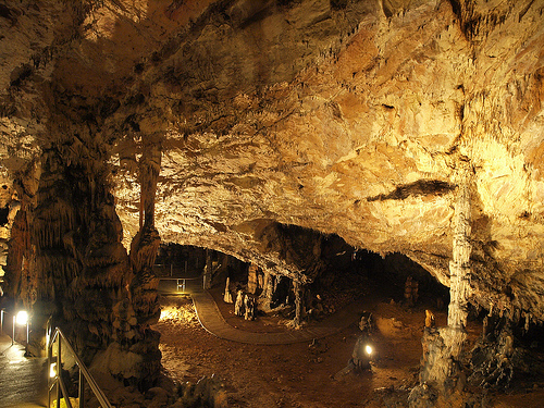
Aggtelek National Park is located near Sendra, Aggtelek Karst region in Northern Hungary. It covers an area of 198.92 km2 above ground. In 1995 it was added to the UNESCO World Heritage list. Aggtelek National Park is particularly notable for underground caves and its biosphere. The longest cave is Baradla- Domica Cave that is 26 km long. About 8 km of the system extends into neighboring Slovakia. Area of Aggtelek National Park was inhabited by humans at least 7000 years ago. Today concerts are held here in a massive underground cavern. Its tallest stalagmite is Czillagvizsgalo (Hungarian for "Stargazer") reaches a height of 62 feet. Peace Cave was used since the early 20th century as a sanatorium for people suffering from asthma. A network of well marked trails allows tourists to explore the rich biosphere above ground. The longest trail Tohonya- Kuriszlán is 10 km long, Baradla 7.5 km, Szadvar 4.5 km "In Harmony with Nature" 4 km and Fürkész is only 1.5 km long. For more information you can visit Kúria Study Centre for more information on Aggtelek National Park.
|
Baradla Cave 1, 2, 4, 5, 7 hour cave tours Open: April- Sept 9am- 7pm Oct- Mar 9am- 4pm
|
Rákóczi Cave Open Apr- Sept 9am- 7pm Oct- Mar 9am- 4pm |
Vass Imre Cave Open: Apr- Sept 9am- 7pm Oct- Mar 9am- 4pm |
Beke Cave, Kossuth Cave, Meteor Cave Open: by appointments |
Geography
Its location
The national park is
located on an area of 20,170 hectares in the Aggtelek karst, in
the Hungarian part of the Gömör-Tornai karst. The area is basically
located at a low mountain-hill level, with only a few points
reaching the mid-mountain height.
Its landscape units
The
main area of the park is the Aggtelek Mountains, in addition to
the Putnoki Hills in the southwest, the Alsó Hill in the northeast,
and the Szalonnai Mountains, the Bódva Valley and the Rudabánya
Mountains in the southeast.
Earth history and rocks
The
geological development history of the area can be traced back to the
end of the ancient geological period (Paleozoic), the late Permian
(about 250 million years ago), when the long-existing land began to
sink due to the opening of the Vardar Ocean. In the warm, dry
climate, salts (gypsum, anhydrite) were released from the
evaporating water of the lagoons, and in wetter periods, clay washed
away from the land was deposited.
The area was largely
inhabited during the Middle Ages (Mesozoic) Triassic, approx. It is
built up of rocks formed 240-210 million years ago. At first, the
rubble-sedimentary rocks (sandstone, shale) were deposited, later,
with the deepening of the sea, more and more calcareous materials
(marl, limestone, limestone) were deposited. Karst phenomena
developed after the limestone surfaced and the destruction of young
sediments covering it. Most of the Aggtelek karst region is a
typical limestone plateau: in this relatively small area we can
observe almost all forms of moderate belt karst development from the
Pleistocene to the present day.
Lime mud settled not far from
the shores of the marginal seas of the Tethys Ocean, which separated
Eurasia and Africa. In some parts (such as Red Lake), the skeletons
of the former reef-forming organisms are beautifully recognizable,
while in other parts, the former bottom-dwelling and mud-eating
animals have been turned through beyond recognition. The bituminous
limestones and dolomites of the Gutenstein Formation are darker in
color than the thick-bedded, excellently karsticized Steinal
limestone, and the Wetterstein limestone, which is more than a
kilometer thick.
In Crete (145-65 million years ago), strong
crustal movements shattered, crumpled, and pushed the limestone mass
into other rocks in blankets and scales. At the end of the period,
the area became dry again; the present mountain range probably began
to become karstic at this time. Later, in the Neogene, the lower
spatial parts were again flooded by the sea several times, and on
the present plateaus volcanic tuff fell several times (in the
Miocene) and a large river spread its gravelly alluvium on it.
The remnants of volcanic tuff are the Mediterranean-style terra
rossa (red clay) that has survived mostly as the filling of ancient
ruins. Various surface and subsurface karst forms developed in the
prominent limestone blocks. The products of the Pleistocene and the
present are even debris cones, slope debris, stream sediments, as
well as clay, gravel and tuff deposited in caves, an excellent
spring limestone at the foot of the mountains. Characteristic
surface shapes, rocky valleys and rows of ridges also developed in
the Quaternary.
Hydrography
The properties of the rocks of
the karst region make it difficult to delimit the individual river
basin districts. The water flow of each karst spring also varies
greatly depending on the amount of precipitation. On the limestone
soil, mostly standing waters with a small area and depth were
formed, which can be basically divided into two groups: the
so-called stagnant water formed in the holes. multiple lakes (e.g.,
Red Lake) or stagnant waters formed in clogged sinks (e.g., Lake
Aggtelek). Periodic lakes can also form in rainy weather. There are
also artificial lakes in the national park, such as the popular Lake
Tengerszem or the fishpond in the Ménes Valley and the Rakaca
Reservoir.
There are ninety and large karst springs in the
Aggtelek karst. The highest yielding watercourse in the national
park is the Jósva stream near Jósvafő, which is fed by the largest
karst springs (Jósva, Kis- and Nagy-Tohonya and Kajta springs), and
flows into the Ménes- patak is. Jósva eventually opens into Bódva.
The Telekes stream, which also flows into Bódva, also has a
significant catchment area.
In 1940 and 1951, the surface of the Baradla Cave,
in 1953 the Peace Cave, in 1956 the Freedom Cave, and in 1958 the
Vass Imre Cave were declared a nature reserve. In 1962, all caves in
the karst area were protected as a result of Legislative Decree No.
18 of 1961 on nature conservation.
In 1978, the President of
the National Office for Environment and Nature Protection 8/1978.
With the resolution No. OKTH, it established the Aggtelek Landscape
Protection Area, which operated within the organization of the Bükk
National Park. In 1979, UNESCO declared the landscape protection
area a biosphere reserve in the HAC (Human and Biosphere) program,
and designated two core areas in the Haragistya and Nagyoldal areas.
The core area of the biosphere reserve is about 2.35 km². In 1983,
some areas of Estramos Hill were also attached to the landscape
protection area.
The Aggtelek National Park was established
on January 1, 1985 on an area of 19708 hectares, which was
approved by the President of OKTH on 7/1984. (XII. 25.) on the site
of the Aggtelek Landscape Protection Area. It was first based in the
Tourist Hostel building in the reception area of the Baradla Cave,
then it was moved to Jósvafő. Later, the Aggtelek National Park was
granted the first-degree nature protection authority, which is
exercised in the assigned area of competence - the area bounded by
the Sajó, the Hernád and the state border. The park was expanded in
2001 to declare the whole of Mount Estramos protected, reaching an
area of 20,170 hectares.
Natural values
The caves
The
Gömör – Tornai karst features the moderate belt mid-mountain karst
phenomena in a unique density and variety all over the Earth: about
1,200 caves are known in the area, 273 of them open in Hungary,
within the borders of the Aggtelek National Park, 25 of which are
highly protected. The caves are also extremely diverse: there are
active creek, vertical and fissure mine caves and tufts. About
two-thirds of the internationally accounted basic types of carbonate
deposition can be observed in some caves: hanging and standing
stalactites, stalactite columns, stalactite flags, helicites,
limestone tuff, aragonite bushes, pea stones.
The caves of
the Aggtelek Karst and the Slovak Karst were declared a World
Heritage Site by the UNESCO World Heritage Committee at its meeting
in Berlin on 6 December 1995, at the same time as the Carslbad
Caverns National Park in New Mexico (USA). Previously, the cave was
only listed twice as a natural value on the World Heritage List:
first the longest cave in the world, the 560 km Mammoth Cave (USA,
Kentucky), and then the world's largest underground riverbed, the
Skocjan Cave in Slovenia, was declared a World Heritage Site. part
of.
The World Heritage Convention states that only the most
outstanding, most intact natural values that can be preserved can
apply for this title. The main professional arguments of the
application material for the Aggtelek and Slovak Karst Caves,
jointly prepared by Hungary and Slovakia and submitted to the World
Heritage Committee, were the extreme diversity, complexity and
relative integrity of the underground world.
The two caves of
the National Park are also world records: the 25-kilometer
Baradla-Domica cave system, which extends to Slovakia and is mostly
located in Hungary, is the longest active stream cave in the
temperate zone, and the Szilice-ice is .
The Meteor Cave is
home to one of the largest underground halls in Hungary, the Titans
Hall, which is named after the huge stalactites in the middle.
Surface karst phenomena
The most common karst form of the
plateaus, the multi-layered, funnel-like limestone plate - is called
dolina in Slovak, but in Hungarian the word dolina refers to another
surface karst form (blind valley). We can also find various arm
fields - also known as devil's plows - (root arm, lattice arm, slope
arm, rock arm), especially on the side of the Tó Hill in Aggtelek.
The sinkholes formed on the karst plateaus, in the ridges and dolins
ensure the replenishment of the caves.
Flora
The Aggtelek Karst is an independent flora tour on
the border of the Pannonian and Carpathian flora regions. In a
relatively small area, the flora is extremely diverse and rich in
species. This is due to the varied terrain: the karst plateaus, the
southern slopes, the caves, the deep gorge valleys and the
multi-hole holes with an extreme microclimate all provide a
different kind of living space for creatures with different needs.
In the Aggtelek National Park, a 1,327-hectare forest reserve
was established; its core area is 596 hectares. Its most common
forest association is hornbeam-sessile oak (Querco
petreae-Carpinetum), mid-mountain beeches and gorge forests grow in
the deeper gorges, and linden-ash rocky steppe forests grow on the
plateaus. In the southern, slightly warmer regions, there are fluffy
oak bush forests alternating with rocky grasslands and sloping
steppe patches.
Of the herbaceous species, the highly
protected, endemic gymnastic blood is one of the park’s most feared
treasures. Austrian dragonflies, which are also highly protected,
are also a rarity. Common plants in karst fields are the common
anemone, early white carnation, and cockscomb.
In the stream
valleys, relatively large marsh meadows, contiguous highlands and
high pathos, and alder groves grow on the shores. Valuable, rare
plants live on woolly marsh patches formed on layer sources that are
constantly leaking at the edges of the valley bottoms.
Fauna
The diversity of habitats and plants brought with it the diversity
of animal species living here. There are 413 protected and highly
protected animal species in the ANP area. The large game population
of the forests is rich, the main representatives are red deer, deer
and wild boar. It is gratifying that large carnivores such as the
wolf, [1], or lynx have also recently re-established in the Northern
Central Mountains. Among the small mammals, it is important to
mention the ground squirrel population, as it serves as a prey for
birds of prey in the area - mouse hawks and rare imperial eagles.
The only species of grouse nesting in Hungary, the emperor, breeds
in the forests of the national park, but we can also find
bullfinches, woodpeckers and yellow-headed queens - the latter
mainly in the planted pine forests. A relatively large number of
kingfishers live along the waters, but we can only rarely see
aquatic thrushes. The typical birds of the open areas are the gypsy
pike and the prickly pear.
The ANP is also home to many
reptile species: forest, aquatic, checkered, and copper gliders also
occur here. Of the lizards, the Pannonian lizard is the most
valuable, and of the amphibians, the spotted salamander in the coat
of arms of the park should be highlighted. The fish stock of karst
waters is also very rich: 42 species have been counted so far, 13 of
which are protected. For example, the stone strip and the
bottom-passing sparrow live near the spring, and the characteristic
inhabitants of the lower sections are the looking-up sparrow and the
Petényi barbel, or the Tisza ingola, which also parasitizes the
former.
The insect world is also very diverse. The number of
butterflies alone exceeds two thousand! The largest domestic herd of
the small Apollo butterfly lives in the national park, but protected
swallowtail and swordfish are common. Among the straight-winged
ones, the Transylvanian short-winged grasshopper or the large
predatory saw-footed grasshopper should also be mentioned. Only here
in Hungary does the green heron occur. The warm demanding praying
locust can also be found on the south-facing slopes.
The
caves have separate, unique wildlife. There are more than five
hundred cave-dwelling and cave-loving species in the Aggtelek karst
region, many of which are rare (for example, the Hungarian blind
foxtail, the Agteltelek blind fleas, the grain-shaped tern and the
earthworm species Allolobophora mozsariorum, which has so far only
been found in meg). Of the 28 bat species living in Europe, 21 occur
in caves in the national park.
The only state-owned huculmen
of Hungary with more than 120 horses can be seen in the park.
Cultural values
The area of the Aggtelek National Park is
rich not only in natural, but also in cultural and historical
curiosities. The prehistoric site of Rudabánya is also of
outstanding importance in the world. The anthropoids found here
(Rudapithecus hungaricus) lived in this area 11.5-10 million years
ago.
Representatives of Homo sapiens have been present in the
area since prehistoric times. Farming began in the Neolithic era.
Tools referring to the culture of Bükk, the remains of pottery with
line decoration were found in large numbers. From the Bronze Age and
the Early Iron Age, many gold objects, bracelets, rings, and pieces
of black pottery have survived.
The surrounding settlements are of medieval
origin. We can find beautiful memories of the reconstruction after
the Tartar invasion in the karst region. On the outskirts of
Martonyi, in the woods, is the Pauline monastery, founded in 1347,
the restoration of which is still underway. The bacon can be seen in
the Árpádian round church of 12th century origin, later expanded
with a semicircular apse, the murals of which were made in 1426 by
the master András of Spiš. The twin-sanctuary church in
Tornaszentandrás is unique in the history of Hungarian architecture,
and similar solutions can only be found in the vicinity of Merano,
Italy. Rakacaszend, Zubogy and Ragály boast a Romanesque church.
Szádvár, one of the largest castles in Hungary, built in the
1250s, is located in the territory of the national park. Béla was
raised to defend the tournament estate. The older past is evoked by
the remains of earth castles (such as Mohosvár in Kelemér), while
the Baroque-style castle of Tornanádaska, the counts of Gyulay and
then the Hadik family are newer. One of the monuments of modern
history is not far from Szádvár: the Polish village of Derenk was
liquidated in 1943 to create a hunting ground where the remains of
houses, a cemetery and the ruins of a school still stand.
It
is worth mentioning the diverse offer of folk architecture, which
presented the settlements of the area with the folk motifs,
decorated porches and facades typical of the Palóc buildings.
Environmental education
The management of the Aggtelek
National Park attaches great importance to the environmentally
conscious education and dissemination of knowledge among young
people. To this end, the educational center opened its doors in
Jósvafő in 2004, which organizes lectures, classroom and field
exercises, tours and a forest school. On the tours we can get
acquainted with the villages, surface, flora and fauna of the park.
The park awaits the visitor with performances and hiking
programs on prominent conservation days, such as World Water Day,
Earth Day or Bird and Tree Day. Under the auspices of the National
Park, the Jósvafő handicraft camp, the nature knowledge camp and the
bird migration research camp are regularly organized, where those
interested can immerse themselves more deeply in the wonders of
nature.
The ANP takes care of informing and training not only
the youth, but also the teachers. It also provides space for
scientific research.
Educational trails
ANP's seven study
trails:
Baradla educational trail (1983),
Tohonya-Kuriszlán
Educational Trail (1995),
Lower Hill Zsombolyos Educational Trail
(2000),
Szádvár educational trail,
Badger educational trail,
Scouting educational trail,
Bódva Valley educational trail (2005,
renovated: 2011).
Along these, several information boards and
showrooms have been set up.