Location: Veszprém county Map
Constructed: 1263 by Baron Jakab Cseszneky
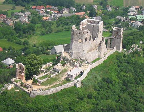
Csesznek Castle is situated in the village of Csesznek, within Zirc District of Veszprém County, Hungary. This places it in the Central Transdanubia region of the country, approximately midway between the cities of Győr to the northwest and Zirc to the southeast. The castle's precise coordinates are 47°21′04″N 17°52′54″E, positioning it atop a prominent hill in the Bakony Mountains, a key upland area in western Hungary. Built around 1263 following the Mongol invasion, the structure was strategically placed in a dense forested area at the intersection of important historical routes, enhancing its defensive role in the landscape.
Construction and Early History (13th Century)
The
castle's origins trace back to around 1263, shortly after the Mongol
invasion, when many fortifications were erected to prevent future
incursions. It was built by Jakab Cseszneky (also known as Jakab of
Csesznek), a prominent noble from the ancient Bána kindred—whose lineage
may extend to the 10th century—and swordbearer to King Béla IV. The name
"Csesznek" likely derives from the Slavic term "czestnik," meaning
castellan or cupbearer, rather than local legends involving a noble's
pig and a snake.
The initial structure was modest: a large
residential tower (possibly one or two) surrounded by basic walls and
fortifications, situated in a dense forested area at the junction of key
trade routes through the Bakony hills. Archaeological evidence confirms
13th-century remains, including early stratigraphy and finds that define
this foundational phase. The first documented mention appears in 1281,
recording joint ownership among Jakab's sons. By the end of the 13th
century, it had passed to the powerful Csák family, who conquered it in
1315 amid regional power struggles.
Medieval Ownership,
Expansion, and Royal Ties (14th–15th Centuries)
Following the defeat
of oligarchs like the Csáks, the castle became a royal possession under
King Charles Robert (Róbert Károly) in the early 14th century. It
remained a royal castle from 1326 to 1392, serving as a strategic asset.
In 1392, King Sigismund of Luxembourg (later Holy Roman Emperor) granted
the castle and 31 surrounding villages to the influential Garai (Gara)
family in exchange for the Banate of Macsó, a lucrative border region
ceded to mitigate Ottoman threats. Under the Garais, the castle
underwent major reconstruction in the late 14th and early 15th
centuries, replacing the original 13th-century structure with a more
elaborate Gothic design. This phase involved a single primary building
period with adjustments, resulting in the core layout still visible
today: an upper castle with a central courtyard dividing residential and
functional spaces, including a great hall, bedrooms, storage areas, and
defensive upper levels. The architecture emphasized cultural prestige
over pure defensibility, with heraldic elements like a gargoyle bearing
coats of arms.
Notable Garai figures include János Garai, whose wife,
Princess Hedvig of Mazovia, was accused of poisoning him, adultery, and
other scandals, leading to her life imprisonment—a tragic episode amid
family quarrels. The Garai male line extinguished in 1482, after which
King Matthias Corvinus seized it and donated it to Stephen Zápolya
(Szapolyai). Subsequent owners included János Szapolyai (later King John
I of Hungary), Bálint Török, and Pál Bakics, reflecting the turbulent
politics of the era.
Ottoman Wars, Conflicts, and Fortifications
(16th–17th Centuries)
As Ottoman expansion threatened Hungary in the
16th century, Csesznek transformed into a frontier fortress. After the
fall of Veszprém and Győr in 1594, the garrison surrendered without a
fight to the Turks, who briefly occupied it. It was soon recaptured, and
modifications for Ottoman warfare included artillery-type openings in
the upper castle and east tower.
A key figure was castle captain
Lőrinc Wathay, who defended it valiantly; his son, Ferenc Wathay, gained
fame as a poet and memoirist in Hungarian literature, chronicling the
era's hardships. Post-Ottoman expulsion, further interventions occurred
in the late 17th century.
During Rákóczi's War of Independence
(1703–1711), the castle served as a vital supply hub for the Kurucs
(Hungarian rebels) against Habsburg rule. It withstood sieges by
Imperial (Labanc) forces, but in 1709, Habsburg troops occupied it,
stripping its military role.
Esterházy Era, Baroque
Transformation, and Decline (18th–19th Centuries)
Ownership passed to
the wealthy Esterházy family in 1635, who initiated rebuilding after
Ottoman damages. Interrupted by the Kuruc period (1705–1709),
reconstruction resumed, reaching its zenith under Ferenc Esterházy
around 1740. He converted the fortress into a luxurious Baroque palace,
adding residential features while preserving defensive elements. It
served as the family's home until the late 18th century, when they
relocated to Réde Castle, abandoning Csesznek.
The castle's decline
accelerated due to natural disasters: earthquakes, lightning strikes,
and fires ravaged it repeatedly. A severe earthquake in 1810 caused
extensive structural damage, followed by a lightning-induced fire that
destroyed the roof. By 1828, it was officially deemed a ruin. Locals
quarried its stones, nearly obliterating the lower castle sections.
Archaeological Research, Modern Renovations, and Current Status
(20th Century–Present)
Archaeological interest revived in the 20th
century. An initial architectural survey occurred in 1960, with
systematic excavations and conservation beginning in 1967 under experts
like Nóra Pamer (1967–1969), Csaba László (1979–1981, 2001–2002), and
Miklós Rácz (2003–2006). These efforts involved stratigraphy, masonry
analysis, and 3D digital reconstructions using GIS and AutoCAD,
revealing phased developments, spatial layouts (e.g., courtyard-centered
design with residential and defensive zones), and historical depictions
of lost elements. Challenges included prior conservations obscuring
details, but the work evaluated artifacts, written records (from
13th–19th centuries), and analogies to reconstruct the castle's
evolution.
Renovations recommenced in 2017 under Hungary's National
Castle Programme, focusing on restoration and accessibility. Today, the
ruins attract tourists with their dramatic setting, offering insights
into medieval life through preserved towers, walls, and courtyards. It
remains a cultural icon, symbolizing Hungary's turbulent past, and is
continually enhanced with visitor amenities like paths and exhibits.
Topography and Terrain
The castle occupies a
commanding hilltop position, often described as perched on a cliff or
rocky outcrop, which provides panoramic views over the surrounding
valleys and forested expanses. This elevated site, typical of medieval
fortifications in the region, rises sharply from the rolling hills of
the Bakony, with the castle ruins spanning a significant area including
a characteristic bergfried (donjon) accessible via a drawbridge. The
Bakony Mountains themselves form part of the Transdanubian Mountain
Range, characterized by karst topography with limestone formations, deep
valleys, and plateaus reaching elevations up to around 700 meters above
sea level in the broader area, though the castle's specific hill is
estimated at about 400-500 meters based on local contours. The terrain
around Csesznek is rugged, with steep slopes leading up to the castle,
making approaches challenging—historically ideal for defense but now a
draw for hikers. Nearby, the landscape transitions into the High Bakony
(Magas-Bakony), a subregion known for its higher elevations and more
dramatic relief compared to the lower, gentler hills elsewhere in the
Bakony.
The immediate vicinity features a mix of eroded limestone
ridges and small gorges, shaped by geological processes over millennia,
including tectonic uplift and water erosion that have carved out the
area's distinctive features. To the north and east, the terrain descends
into broader valleys that historically facilitated trade routes, while
southward it integrates with denser woodland and additional hilly
outcrops.
Environmental and Ecological Context
The geography
of Csesznek Castle is deeply intertwined with the lush, forested
environment of the Bakony Mountains, which cover much of the area with
mixed deciduous and coniferous woods, including beech, oak, and pine
species. This creates a verdant backdrop, especially vivid in summer,
with green canopies enveloping the hills and providing a natural buffer
against erosion. The region is part of a protected landscape area,
emphasizing its biodiversity, with habitats supporting wildlife such as
deer, birds of prey, and various flora adapted to the karst soils.
Hydrologically, the Bakony features numerous springs and small streams
that originate from the porous limestone, feeding into larger rivers
like the Marcal to the west, though no major water bodies directly
adjoin the castle site itself.
Climate-wise, the area experiences a
temperate continental influence, with mild summers (averaging 20-25°C)
and cold winters (down to -5°C or lower), moderated by the mountainous
terrain that can lead to higher precipitation—around 700-800 mm
annually—fostering the dense vegetation. Fog and mist are common in the
valleys, adding to the dramatic atmosphere, while the hilltop location
exposes the castle to stronger winds and occasional thunderstorms.
Nearby Geographical Features and Accessibility
Proximate
landmarks include the Gyarmatpuszta area to the southwest, known for its
hilly coastal-like formations along Hungary's inland "seas" of terrain,
though more accurately described as undulating plateaus. The castle
overlooks the village of Csesznek below, with paths winding through the
forests for access—visitors typically approach from Várhegy köz,
ascending via trails that highlight the steep gradient. Broader
connectivity ties into the Bakony's network of hiking routes, part of
the National Blue Trail system, linking to other sites like the
Kőris-hegy peak (709 m), the highest in the Bakony, about 15 km
southeast. Geologically, the area reflects Mesozoic-era limestone
deposits, prone to cave formations nearby, such as those in the Bakony
karst system, adding subterranean dimensions to the surface geography.