Age: 2,800 years
Height: 660 ft (200 m)
Width: 1 mile (1.6 km)
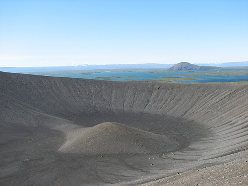
Hverfjall, also known as Hverfell, is a striking tephra cone or tuff ring volcano located in northern Iceland, renowned for its symmetrical, bowl-shaped crater and dramatic black ash appearance. This geological marvel stands as one of the largest and best-preserved explosion craters in the world, offering a glimpse into Iceland's volatile volcanic past. Situated near the eastern shore of Lake Mývatn, it forms part of the Krafla fissure swarm, a region teeming with geothermal activity and diverse landscapes.
Hverfjall is positioned at coordinates approximately 65°36′00″N 16°53′00″W, rising prominently from the volcanic plains east of Lake Mývatn in North Iceland. The crater itself measures about 1 kilometer (0.6 miles) in diameter, with a depth of around 140 meters (459 feet) and steep walls that contribute to its imposing profile. Its elevation reaches 420 meters (1,380 feet) at the highest point on the rim, while the structure stands roughly 396 meters above the surrounding terrain, creating a towering black ash cone that dominates the horizon. The slopes are covered in dark volcanic tephra, giving the site an otherworldly, lunar-like aesthetic, though a landslide during its formation disrupted the perfect circularity on the southern side.
Hverfjall Crater (also known as Hverfell) is a prominent tuff ring
(or transitional tuff cone) in northern Iceland, located east of Lake
Mývatn in the southern part of the Krafla fissure swarm within the
Northern Volcanic Zone. It formed during a basaltic fissure eruption
known as the Hverfjall Fires approximately 2,500 years BP (~500 BCE).
This makes it one of the youngest and best-preserved examples of its
kind globally.
Tectonic and Regional Volcanic Setting
Hverfjall sits along the Mid-Atlantic Ridge in Iceland’s active rift
zone, where the North American and Eurasian plates diverge at ~2
cm/year. The Krafla volcanic system features a ~10 km-wide, ~100 km-long
fissure swarm active for ~200,000 years, with post-glacial activity
shaping the Mývatn region through multiple eruptive cycles (Lúdent,
Hverfjall, and later Mývatnseldar). The Hverfjall Fires activated a ~50
km-long NNE-SSW fissure segment, with the most intense activity
concentrated at its southern tip near Mývatn.
The area’s permeable
young basalts and shallow groundwater (influenced by the proto-Lake
Mývatn) created ideal conditions for phreatomagmatic activity. The
eruption followed a long period of quiescence in the Mývatn area and
occurred alongside effusive and magmatic explosive activity elsewhere on
the fissure.
Eruption Chronology and Phases
The Hverfjall
eruption (studied in detail by Mattsson & Höskuldsson 2011) produced a
mix of pyroclastic and effusive deposits along the fissure. It divided
into three main phases based on vent locations and depositional styles:
Initial Phase (Phreatomagmatic, High Eruption Rate): Rising basaltic
magma interacted violently with shallow surface water or groundwater in
a lacustrine setting. This generated powerful steam explosions,
producing widespread fine-grained black tephra fall deposits traceable
up to ~20 km away (with isopachs elongated NNE-SSW). High magma flux
drove sustained eruption columns and initial base surges.
Second
Phase (Mixed Activity, New Vents on Dry Ground): As the fissure
propagated, new vents opened on drier ground. This led to
contemporaneous magmatic (dry) activity at the nearby Jarðbaðshólar
scoria cone complex, producing scoria and lava flows, while Hverfjall
remained hydromagmatic. Interbedded magmatic and hydromagmatic deposits
confirm simultaneous activity at both vents. Magma supply to Hverfjall
eventually decreased.
Final Phase (Lower-Rate Explosions and Surges):
Reduced eruption rate at Hverfjall shifted deposition toward base-surge
dominated processes, with more proximal, heterogeneous lapilli tuffs.
The entire Hverfjall vent activity was short-lived and monogenetic
(single eruptive episode). Total tephra volume is estimated at
~0.13–0.15 km³.
Formation Mechanism: Phreatomagmatic Processes
Hverfjall exemplifies phreatomagmatic (hydromagmatic) volcanism, where
ascending basaltic magma encountered external water, causing rapid
quenching, thermal shock, and explosive fragmentation. Unlike purely
magmatic eruptions, this produced mostly fragmented tephra rather than
lava flows at the main vent.
Key insights from Liu et al. (2017):
Magma vesiculated significantly prior to magma-water interaction
(MWI), as shown by overlapping vesicularity and bubble number densities
in both magmatic (Jarðbaðshólar) and hydromagmatic (Hverfjall)
pyroclasts.
Fragmentation was primarily brittle: thermal stress from
rapid quenching caused fracturing controlled by the pre-existing bubble
population. Blocky ash dominates finer fractions (< modal bubble size),
while vesicular particles and bubble shards make up most of the mass in
the total grain-size distribution.
This interaction occurred in a
shallow-water environment, leading to fall-dominated early deposits
transitioning to surge-dominated later ones.
Structure,
Morphology, and Stratigraphy
Hverfjall is nearly perfectly circular
(disrupted only on the south side by a syn-eruptive landslide) with:
Crater diameter: ~1 km
Depth: ~140 m
Edifice height: ~125–150 m
above surroundings (total elevation ~396–420 m)
Slopes: averaging
~15° (up to 18°), close to the angle of repose for loose tephra
The rim consists of outward-dipping (15–35°) tephra beds. Exposed inner
stratigraphy shows ~87.5 m of heterogeneous lapilli-rich beds in a
partially palagonized ash matrix, including accretionary
pellets/lapilli, cross-bedding, lithic fragments, and bombs. Proximal
surge deposits can reach several meters thick; medial-distal falls are
finer and massive.
A small central hill/mound inside the crater floor
may result from late-stage minor activity or post-eruptive accumulation.
Composition and Deposits
The edifice comprises unconsolidated
basaltic tephra—primarily glassy sideromelane (basaltic glass) ash,
lapilli, and scoria, with minor phenocrysts of plagioclase, olivine, and
clinopyroxene (often skeletal). Particles are rugged to blocky, with low
vesicularity (<15 vol.%) in many hydromagmatic clasts. Deposits include:
Fine-grained black fall units (basal, widespread)
Lapilli tuffs from
base surges (poorly sorted, cross-bedded, with accretionary features)
Minor bombs and lithics
Tephra dispersed widely across the Mývatn
area. Unlike solid lava constructs, the loose material makes the cone
vulnerable to erosion, though its youth and dry climate have preserved
its sharp geometry remarkably well.
Post-Eruption Modifications
During the Settlement period (Viking Age), lavas from Svörtuborgir
flowed around the base, nearly encircling the cone without burying it.
Wind, freeze-thaw, and minor gullying have caused subtle erosion, but
foot traffic on trails now accelerates localized slumping. The south rim
landslide scar remains visible.
Geological Significance
Hverfjall is one of Iceland’s largest and most symmetrical tephra
cones/tuff rings, serving as a classic field site for studying
phreatomagmatic processes in basaltic systems, magma-water interaction,
fragmentation dynamics, and monogenetic volcanism. Its proximity to
pseudocraters, rootless cones, lava fields (e.g., Dimmuborgir), and
geothermal features in the Mývatn area highlights how subtle variations
in water availability and eruption rate produce diverse landforms from
similar magma. It remains a protected natural monument and popular
hiking site (rim trail ~3–4 km, with panoramic views).
The crater's interior is a vast, bowl-shaped depression with steep, eroded walls that reveal layers of compacted ash and tuff. From the rim, which rises up to 200 meters (656 feet) high in places, visitors can enjoy panoramic vistas encompassing Lake Mývatn's serene waters, the bizarre lava pillars of Dimmuborgir (formed from a collapsed lava tube about 2,000 years ago), and the expansive Krafla lava fields. Nearby, the Skútustaðagígar pseudocraters—created by steam explosions when lava met marshy ground around 2,300 years ago—serve as a wetland haven for birdwatching. The Krafla area itself features the Víti crater (300 meters wide, formed in 1724) along with hot springs and mud pools, highlighting the region's ongoing geothermal energy. Lake Mývatn, a key attraction, offers unique geological formations, boating opportunities, and rich biodiversity, while the Mývatn Nature Baths provide relaxing geothermal soaking with views of Hverfjall. The entire Mývatn district, including Hverfjall, evidences human presence dating back 9,000 years and has even served as a filming location for scenes in the HBO series "Game of Thrones."
By Car (Recommended)
Renting a car gives you the flexibility to
explore the surrounding Mývatn area. A 4x4 vehicle is advised due to
potential gravel roads and variable weather conditions—check road.is for
real-time updates before heading out.
From Reykjavík (about 470
km, 5-6 hours drive): Head north on the Ring Road (Route 1) toward North
Iceland. Continue past Akureyri, then turn onto Route 848 toward Lake
Mývatn. Follow signs for Hverfjall; it's roughly 6 km east of
Reykjahlíð. From Route 848, take the signed gravel road (Route 8816) for
about 2 km to the parking area.
From Akureyri (about 90 km, 1-1.5
hours drive): Take Route 848 east directly toward Lake Mývatn, then
follow the same signs and gravel road to Hverfjall as above.
There
are two free parking lots at the base: one on the north side (main
access) and one on the south. No entrance fee, but arrive early in peak
summer months to avoid crowds.
By Public Transport
Options are
limited in this rural area, with no direct buses to the crater itself.
You'll need to combine bus travel with walking, a taxi, or a local ride.
Take Strætó bus line 56, which runs between Akureyri and Egilsstaðir
with stops in the Mývatn area (e.g., at Reykjahlíð). From there, it's
about 6 km to the crater—walkable in 1-2 hours along the road, but not
ideal in bad weather. Alternatively, arrange a taxi from Reykjahlíð
(expect 5,000-10,000 ISK one-way) or hitch a ride, which is common in
Iceland.
Schedules are infrequent outside summer, so check straeto.is
for timetables. Public transport isn't reliable for day trips
here—consider it only if you're staying nearby.
By Organized Tour
If you don't want to drive, join a guided tour from Akureyri or
Reykjavík that includes the Mývatn region. Many operators like Gray Line
or Reykjavik Excursions offer day or multi-day trips covering Hverfjall,
often with transport in comfortable buses or vans. Search for "Lake
Mývatn tours" on sites like Viator or GetYourGuide for options starting
around 15,000 ISK per person.
Once You're There: The Hike
From
the parking lot, follow one of the two marked trails up to the rim
(steep but well-maintained, with loose gravel). It takes 20-40 minutes
to ascend about 100 meters, depending on fitness level—wear sturdy shoes
and bring layers for wind. At the top, you can walk the full 1 km loop
around the crater for panoramic views of Lake Mývatn and nearby volcanic
landscapes. Stick to paths to protect the fragile environment.
The trail is well-marked with clear paths; off-trail hiking is
strictly prohibited to protect the fragile volcanic environment.
Ascent to the Rim (20–30 minutes, moderate difficulty):
From the main
northern parking lot, the path climbs steadily (about 100–160 m /
330–525 ft elevation gain) over loose ash, gravel, and sand. It’s a
straightforward but calf-burning uphill on a wide, defined track. The
slope is consistent (around 15–20° in places), and most people take
their time here. On a clear day, you’ll start getting teaser views of
the crater interior and Lake Mývatn early on.
The Rim Loop (45–60
minutes, easy):
Once at the top, you’re on the crater’s rim at around
400–560 m above sea level (sources vary slightly on exact figures). The
path follows the circumference in a clear loop—roughly 3–4 km total for
the full circuit when including the up/down. It’s mostly flat and wide
enough for comfortable walking, though it can be narrow in spots with
drop-offs on both sides (one into the crater, one to the outside
slopes). Wind can be strong and gusty up here, so stay alert.
The
views are spectacular: look down into the bowl-shaped crater (often with
a small central mound), across to the pseudocraters and lava fields
around Mývatn, and toward Krafla volcano in the distance. Many hikers
note the best photo spots are about one-fifth of the way
counterclockwise from the main ascent point.
Descent:
Return
the same way you came up (no other routes allowed). The downhill is
quicker but can be slippery on the loose material—take it slow,
especially if wet or icy.
Total stats (main trail round-trip with
full rim loop):
Distance: ~4.3–4.65 km (2.7–2.9 miles)
Elevation
gain: 210–280 m (690–920 ft) total
Time: 1.5–2 hours (faster if
skipping the full loop)
Difficulty: Easy to moderate (steep but short
ascent is the main challenge)
An alternative longer loop combines
Hverfjall with Dimmuborgir (~5.4 miles / 8.7 km, 3.5+ hours, more
elevation, steeper sandy sections on the Dimmuborgir side).
Scenery and Highlights
The crater’s interior is barren and
dramatic—steep, striated dark walls with minimal vegetation. From the
rim, the contrast between the black volcanic rock, blue lake waters,
green mossy patches, and distant snow-capped peaks is unforgettable. On
clear days or during golden hour/sunrise, the light creates stunning
shadows inside the crater. Wildlife is sparse, but you might spot birds
around Mývatn.
Best Time to Visit
May–September: Ideal—long
daylight (midnight sun in June/July), milder temps (10–15°C / 50–59°F),
and drier trails. Fewer crowds early morning or late afternoon.
Shoulder seasons (spring/fall): Quieter, dramatic skies, but check for
wind/rain.
Winter (Oct–Apr): Possible but requires crampons, hiking
poles, or spikes for icy conditions. Some guided sunrise tours operate
here with gear provided. Roads may have snow, and the hike is more
challenging.
Always check the Icelandic Met Office (vedur.is) for
weather—wind and sudden changes are common.
What to Bring and
Safety Tips
Footwear: Sturdy hiking boots or trail runners with good
grip (sneakers can work in dry summer but not ideal on loose gravel).
Clothing: Layers, windproof jacket, rain shell, hat/gloves. It can be
much windier and colder at the top.
Essentials: Water, snacks,
sunscreen (high UV), sunglasses (dusty), phone with offline map (or GPX
track), and a small daypack. Hiking poles are helpful for balance on the
ascent/descent.
Safety: Stay on marked trails only. Strong winds can
make the rim feel exposed—turn back if conditions worsen. No shade, so
hydrate. Emergency number: 112. Inform someone of your plans if hiking
alone.
Leave No Trace: Pack out all trash; the volcanic soil is
delicate.