Location: Map
Height: 82 ft (25 m)
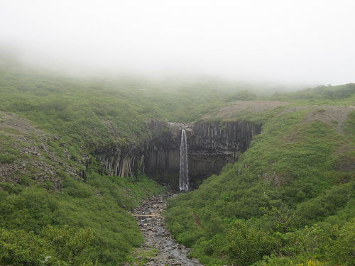
Svartifoss, which translates to "Black Falls" in Icelandic, is one of Iceland's most distinctive and photogenic waterfalls, renowned not for its size or power but for its stunning geological backdrop. Unlike many of the country's more thunderous cascades, Svartifoss features a modest drop where crystal-clear water tumbles gracefully over a cliff adorned with dark, hexagonal basalt columns that resemble the pipes of a massive natural organ. These columns, formed from ancient volcanic activity, create a dramatic contrast against the surrounding lush greenery, moss-covered rocks, and occasional bursts of wildflowers in summer. The waterfall's name derives from the deep, almost black hue of these basalt formations, which frame the falling water like a gothic amphitheater. At the base, shattered fragments of these columns litter the ground, adding to the raw, untamed beauty of the site. Though it may not overwhelm with volume, Svartifoss captivates visitors with its symmetrical elegance and the serene pool that collects at its foot, often reflecting the surrounding scenery in calm weather. Svartifoss Waterfall is located in Vatnajökull National Park (former Skaftafell National Park) in Iceland.
Nestled in the heart of southeast Iceland, Svartifoss is situated within the Skaftafell Nature Reserve, which forms part of the larger Vatnajökull National Park—the largest national park in Europe. This area is characterized by a diverse landscape of birch woodlands, glacial tongues, lava fields, rivers, and streams, all dominated by the massive Vatnajökull glacier. The waterfall is tucked away in a gorge, accessible via hiking trails from the Skaftafell Visitor Center, which lies along Iceland's Ring Road (Route 1), about 327 kilometers (203 miles) east of Reykjavík. Its remote yet reachable position makes it a popular stop for those exploring the South Coast, with coordinates approximately at 64.0278° N, 16.9753° W.
Physical Features and Dimensions
The waterfall drops 20 meters (66
feet) in a single, sheer plunge into a pool below. It flows over a cliff
edge into Bæjargil gorge. What defines Svartifoss is the surrounding
columnar-jointed basalt, forming a horseshoe-shaped natural amphitheater
roughly 15–20 meters high and 30 meters wide. These mostly hexagonal
columns stand like the pipes of a giant organ, creating a striking
contrast between the jet-black rock, white cascading water, and
surrounding green vegetation (moss, ferns, and birch).
The columns’
vertical faces show regular horizontal grooves or striations (spaced
5–20 cm apart), recording stages of cooling and contraction. At their
bases, sharp, broken column fragments accumulate faster than the falling
water can erode them, giving the pool a jagged, rocky appearance.
Geological Formation
Svartifoss’s geology stems from Iceland’s
position on the Mid-Atlantic Ridge, where the North American and
Eurasian tectonic plates diverge, combined with a mantle plume hotspot.
About 300,000 years ago, thick lava flows from volcanic eruptions
covered the area. As the molten basalt cooled slowly and contracted, it
fractured into the iconic hexagonal columns through a process called
columnar jointing—the most regular and striking example of this
phenomenon in Iceland.
Microscopically, the rock consists of
interlocking plagioclase crystals aligned perpendicular to the column
axes, contributing to their strength and visible laminations. The
columns were later exposed and shaped by Pleistocene glaciations, river
erosion, and ongoing weathering. The broader Skaftafell plateau consists
of older basaltic layers (with some sources noting Tertiary influences
in the regional geology), tilted southward and sculpted into valleys and
ridges by ice.
This interplay of volcanism (fire) and glaciation
(ice) is the hallmark of Vatnajökull National Park.
Hydrology and
Water Source
Svartifoss is fed by the Stórilækur river (“Big Creek”),
which originates on the Skaftafellsheiði heath below the Kristínartindar
mountain peaks. The water is relatively clear (not heavily silt-laden
like direct glacial runoff), though the area is near glacier tongues
such as Svínafellsjökull. It flows into Bæjargil gorge before plunging
over the basalt cliff. The flow varies seasonally but remains steady due
to glacial melt and precipitation in this subpolar oceanic climate.
Surrounding Landscape and Ecology
The hike to Svartifoss
(moderate, ~1.5–2 km / 0.9–1.2 miles one way from the visitor center,
with ~140 m / 460 ft elevation gain) passes through diverse terrain:
birch woodlands, mossy lava fields, and smaller waterfalls (Hundafoss,
Magnúsarfoss, and Þjófafoss). The trail is well-marked but can be rocky
or slippery.
The broader Skaftafell area features:
Glacial
influences: Nearby ice tongues and the massive Vatnajökull ice cap.
Volcanic features: Lava fields and black sand plains.
Vegetation:
Surprisingly lush birch forests and mosses, creating a green oasis amid
barren outwash plains—a result of a milder microclimate at the foot of
Öræfajökull (Iceland’s highest peak).
The park showcases extreme
contrasts: fertile valleys versus flood-prone sandurs shaped by historic
jökulhlaups (glacial outburst floods).
Accessibility and Context
From the Skaftafell Visitor Center (with parking, maps, and facilities),
the trail is family-friendly in good conditions but requires proper
hiking gear. The park offers views of glaciers, mountains, and valleys,
making Svartifoss part of a larger scenic network.
Svartifoss’s
unique basalt columns have inspired Icelandic architecture, notably
Hallgrímskirkja church in Reykjavík.
By Car (Recommended for Flexibility)
Driving is the easiest and
most popular option, giving you control over stops along the scenic
South Coast route.
Route: Head east from Reykjavík on Route 1
(the Ring Road) for about 200 miles (320 km). The drive takes
approximately 4 hours without stops, but plan for 5-6 hours to account
for photo opportunities at landmarks like Seljalandsfoss and Skógafoss
waterfalls, Reynisfjara black sand beach, or the Dyrhólaey cliffs.
Turnoff: Look for the signposted exit to Skaftafell just off Route 1,
about 30 minutes past the town of Kirkjubæjarklaustur. It's well-marked
and leads to a short side road (Road 998) to the visitor center parking
lot.
Parking: Free parking is available at the Skaftafell Visitor
Centre, though a small fee may apply in peak season (check on-site). No
4x4 is needed; a standard 2WD vehicle is fine year-round on paved roads,
but winter tires or chains may be required from November to April.
From Other Points: If coming from the east (e.g., Höfn or Jökulsárlón
glacier lagoon), it's about 1-1.5 hours west on Route 1. From Vík, it's
roughly 1.5 hours east.
Renting a car in Iceland is
straightforward via airports or city centers—opt for insurance covering
gravel and ash damage.
By Public Bus
Public transport is
limited but possible, especially in summer (June-August), when schedules
are more frequent. It's a longer journey and less flexible for day
trips.
Main Operator: Straeto (straeto.is) runs bus line 51 from
Mjódd bus terminal in Reykjavík to Skaftafell. The trip takes 6-7 hours
one way, with departures once daily in summer and less often in winter
(check schedules, as weather can cancel services). Cost is around
10,000-15,000 ISK round-trip.
Other Options: Sterna buses offer
similar routes with more stops along the South Coast. For a direct-ish
service, Þingvallaleið (bustravel.is) connects Reykjavík to Skaftafell
in about 6 hours, continuing to Höfn. In winter, options drop to a few
times per week.
Drawbacks: Buses don't run early/late enough for
short visits, and you may need to overnight in Skaftafell (camping or
hotels available). Not ideal for solo travelers without a car.
If
you're not driving, consider joining a guided day tour from Reykjavík,
which often includes transport, a guide, and stops at Svartifoss—book
via sites like Guide to Iceland or Reykjavik Excursions.
Trail Overview
Distance: Approximately 2–2.6 miles (3.2–4.2 km)
round-trip for the standard out-and-back route. Some sources cite ~1.5–2
km one way. A longer loop option (e.g., via other trails in the park)
can extend to 3.4+ miles.
Elevation Gain: Around 120–200 meters
(400–650 ft), mostly gradual but with some steeper sections.
Estimated Time: 1–2 hours round-trip, including stops for photos and
viewing other waterfalls. Allow 45–60 minutes each way at a moderate
pace.
Difficulty: Easy to moderate. The trail is well-maintained with
stairs, boardwalks, and gravel/matted paths to combat erosion. It starts
with a steep uphill section but is suitable for most fit hikers,
including families with older children. Not ideal for those with
significant mobility issues due to inclines and potential slippery
conditions.
Type: Out-and-back (with optional loop extensions).
The trail is part of a larger network in Skaftafell, offering
opportunities to combine with other hikes like those to viewpoints or
glaciers.
The Hiking Experience Step-by-Step
The hike begins
at the Skaftafell Visitor Center (parking available, often with a fee).
The path is clearly signposted and well-maintained.
Initial
Climb: The first section is the steepest — a steady uphill through birch
woodland and open terrain. This gains most of the elevation quickly.
Expect some effort here, but it's short.
Along the Way — Other
Waterfalls: You'll pass several smaller falls, adding variety:
Hundafoss (Tallest of the early ones, impressive volume).
Magnúsarfoss (Smaller, charming).
Others like Þjófafoss may be
visible depending on the exact route.
Approaching Svartifoss: The
landscape transitions to more rugged, mossy lava fields. Near the end,
descend a bit via stairs or a narrow path to a viewing platform and
bridge over the stream below the falls. This is the best spot for photos
and close appreciation of the basalt columns.
At the Waterfall:
The columns create a dramatic amphitheater. Water tumbles over the edge
into a pool, often creating rainbows in mist on sunny days. The
surrounding area has rocks for careful exploration (stay on paths to
protect vegetation).
Practical Tips
Gear: Waterproof hiking
boots with good grip (essential for mud, rocks, or ice), layers, rain
jacket, and trekking poles if desired for stability. Bring water,
snacks, and sun protection in summer.
Crowds: Popular spot — mid-day
in peak summer can be busy at the viewpoint. Early/late timing helps.
Accessibility: Well-maintained but not wheelchair-friendly. No entry fee
for the hike itself (parking may have a small fee).
Extensions:
Combine with longer trails like to Kristínartindar for panoramic views
or glacier walks (guided only for safety).
Safety: Stay on marked
paths to avoid damaging fragile moss. Be cautious near edges, especially
if wet. No major river crossings on the main trail.
Getting There:
Drive along the Ring Road (Route 1) to Skaftafell, about 2.5–3 hours
from Reykjavík or near Jökulsárlón. Public buses or tours also
available.
While Svartifoss lacks ancient folklore ties like some Icelandic sites, its geological features have profoundly influenced modern Icelandic culture and architecture. The basalt columns inspired renowned architect Guðjón Samúelsson in designing iconic structures, including the ceiling of the National Theatre (Þjóðleikhúsið) in Reykjavík and the facade of Hallgrímskirkja, Iceland's tallest church, which mimics the columnar patterns. Additionally, American artist Richard Serra drew from similar formations for his "Milestones" installation on Viðey Island. Historically, the Skaftafell area was a farming settlement before becoming a protected reserve in 1967 and integrating into Vatnajökull National Park in 2008, preserving it as a symbol of Iceland's volcanic heritage.
Preparation: Dress in layers with waterproof clothing, as weather can
change rapidly and spray from the falls can make paths slippery. Bring
water, snacks, and trekking poles if needed for stability.
Access: No
entrance fee for the park or waterfall (as of 2021), but expect a
parking fee at the visitor center. Self-drive is recommended; rent a car
or join a South Coast tour from Reykjavík.
Safety and Etiquette:
Stick to marked paths to prevent erosion, avoid getting too close to the
falls' edge, and pack out all trash. In winter, crampons may be
necessary for ice.
Crowds: Visit early morning or late afternoon to
avoid peak tourist times, especially in summer.
Guided Options: While
no specific tours are required, glacier hiking excursions in nearby
Svínafellsjökull often include a stop here.
Svartifoss is accessible year-round, but summer (June-August) offers the mildest weather, longer daylight, and vibrant greenery, making hikes more enjoyable. Winter visits provide a frozen wonderland aesthetic with icicles and snow, but trails can be icy and challenging, requiring extra caution. Spring and fall bring fewer crowds and colorful foliage or early snow, though weather is unpredictable.
Within Vatnajökull National Park, explore glacier tongues like Svínafellsjökull for hiking or ice climbing. En route along the South Coast, stop at Seljalandsfoss (where you can walk behind the falls) and Skógafoss, or visit the black-sand beaches of Reynisfjara with its own basalt columns. Further east, Jökulsárlón Glacier Lagoon and Diamond Beach are about 30 minutes away, offering stunning icebergs and seals. For a deeper dive into Iceland's geology, the Perlan Museum in Reykjavík features exhibits on volcanic formations similar to those at Svartifoss.