Location: County Mayo Map
Area: 11,779 ha
Ballycroy National Park, located in County Mayo, Ireland, is a pristine wilderness area renowned for its vast blanket bog, rugged mountains, and rich biodiversity. Established in 1998, it spans approximately 11,779 hectares (29,106 acres) on the western edge of Ireland, encompassing the Owenduff/Nephin Beg mountain range and one of the largest expanses of intact blanket bog in Europe. The park is a designated Special Area of Conservation (SAC) and Special Protection Area (SPA), reflecting its ecological significance.
Wild Nephin National Park, also known as Ballycroy National Park,
spans 15,000 hectares in northwest County Mayo, Ireland, along the
Atlantic coast. The primary access point is the Ballycroy Visitor
Centre, located in Ballycroy village off the N59 road, which serves as
the gateway for information, exhibitions, and trails. As of November 2,
2025, the park is open to visitors, but the Visitor Centre operates
seasonally—typically from mid-March to early November (10:00 AM to 5:30
PM, with reduced hours in October/November until around November 5). The
park may close during severe weather (Status Orange/Red warnings) or
high fire risk; always check the official website for updates. Access is
weather-dependent year-round, and remote areas require preparation for
boggy terrain and isolation.
By Car
The most straightforward
way to reach the park is by car, with good road access via the N59 (Wild
Atlantic Way route). The Ballycroy Visitor Centre (postcode F28 RX77) is
centrally located and signposted. Approximate driving times and routes
from major locations:
From Westport (south, ~40 km): Take N59
north toward Mulranny and Achill Island; the Visitor Centre is about
35-45 minutes away.
From Newport (east, ~30 km): Head west on N59
toward Mulranny; approximately 30 minutes.
From Castlebar (southeast,
~50 km): Take N5 west to Westport, then N59 north; about 1 hour.
From
Ballina (east, ~50 km): Take N59 west via Crossmolina; around 1 hour.
From Galway (south, ~120 km): Follow N59 north through Clifden and
Westport; under 2 hours.
From Dublin (east, ~300 km): Take M4/N4 west
to Longford, then N5 to Castlebar, and N59 north; about 4 hours.
From
Sligo (northeast, ~100 km): Take N59 southwest via Ballina; around 2
hours.
Other key access points include:
Letterkeen
Loops/Brogan Carroll Bothy (eastern trails): From Newport, take L1402
(Furnace road) north for ~12 km, then left at junction for ~400 m to
parking (narrow road; drive carefully).
Claggan Mountain Coastal
Trail (western coast): 10 minutes south of Visitor Centre on N59;
parking available.
Parking is free at the Visitor Centre and
trailheads. Roads are generally good, but some interior tracks are
narrow and unpaved—high-clearance vehicles recommended for remote areas.
Use GPS or apps like Google Maps for real-time navigation.
By
Public Transport
Public transport options are limited and seasonal,
with no direct year-round service to the park's interior. The nearest
major hubs are Westport and Castlebar.
Free National Park Shuttle
Bus: Operates Tuesday to Saturday from June 3 to August 30, 2025,
connecting Westport to Bangor-Erris with stops at Newport, Letterkeen
(Shraheens), Mulranny, Claggan Mountain Coastal Trail, Ballycroy Visitor
Centre, and more. It's free and ideal for day trips or trail access
(e.g., hop off for looped walks). Morning and afternoon services
available; example timetable: Westport dep. 11:00 AM, arrives Ballycroy
12:35 PM; return from Bangor-Erris dep. 14:55 PM. Bikes allowed with
advance notice (+353 (0)87 108 4719).
Year-Round Buses: Local Link
Route 460B serves Ballycroy, with the last bus stopping nearby around
7:52 PM. From Westport or Castlebar, connect via Bus Éireann or Local
Link services (e.g., Route 440 from Westport to Achill, then transfer).
From Dublin Airport, Citylink buses run to Castlebar (every 4 hours),
then taxi or local bus (~€50-€70 taxi from Castlebar). Expect walks from
bus stops (e.g., 2 hours from Ballycroy Post Office to some trails).
Check moovitapp.com or locallink.ie for schedules, as services are
infrequent.
By Plane
The nearest airport is Ireland West
Airport Knock (NOC), ~70 km east (~1 hour drive via N5 and N59). From
there:
Car Rental/Taxi: Rent a car at the airport (e.g., Hertz,
Europcar) or take a taxi (~€80-€100).
Bus: Local Link or Bus Éireann
to Ballina or Castlebar, then transfer to N59 services.
Other
options:
Shannon Airport (SNN, ~180 km south): 2.5-3 hours drive via
N18 and N59; buses to Galway, then Citylink north.
Dublin Airport
(DUB, ~280 km east): 3.5-4 hours drive; Citylink bus to Castlebar (~4
hours, €20-€30), then local transport.
No direct flights to the
park; plan for ground transfers.
Additional Tips
From Major
Cities: From Dublin, combine train/bus to Westport (Irish Rail/Bus
Éireann, ~3-4 hours), then shuttle or taxi (~€40-€60 from Westport).
From Galway, direct bus to Westport, then north.
Best Time: Summer
for shuttle access and longer days; off-season (like November) for
solitude but check weather and shorter Visitor Centre hours.
Accessibility: Visitor Centre and some trails (e.g., Tóchar Daithí Bán)
are wheelchair-friendly; dogs allowed on leads. No entry fees.
Practical Advice: Prepare for rain/wind; wear hiking boots, check for
ticks. For camping or remote hikes, register online. Contact +353 (0)98
49888 or ballycroyvisitorcentre@npws.gov.ie for latest info. Always
verify schedules on nationalparks.ie, as changes occur.
Ballycroy National Park, located on the western seaboard in northwest
County Mayo, Ireland, is a vast wilderness area renowned for its
Atlantic blanket bog, mountainous terrain, and ecological significance.
Originally established in November 1998 as Ireland's sixth national
park, it encompassed approximately 11,000 hectares of largely
uninhabited land dominated by the Nephin Beg mountain range and the
Owenduff bog—one of the last intact active blanket bog systems in
Ireland and Western Europe. The park was managed by the National Parks
and Wildlife Service (NPWS) under the Department of Arts, Heritage, and
the Gaeltacht (now the Department of Housing, Local Government and
Heritage). In 2018, following a significant expansion, it was renamed
Wild Nephin National Park to reflect its broadened scope and emphasis on
rewilding, now spanning 15,000 hectares as part of the Natura 2000
network, which protects rare habitats and species under EU directives.
This history intertwines geological processes, human interactions,
conservation efforts, and modern developments, highlighting the area's
transition from a utilized rural landscape to a protected wilderness.
Geological and Natural Formation
The park's landscape is a
product of extensive glacial activity over the past 2.5 million years,
during the Pleistocene epoch. Ice sheets sculpted the terrain, leaving
behind corrie lakes such as Corryloughaphuill Lough and deposits of
glacial boulder clay, particularly at the southern edge of the Nephin
Beg mountains. Post-glacial warming around 10,000 years ago facilitated
the formation of the Atlantic blanket bog, a peatland ecosystem that
developed in the region's high rainfall (over 2,000 mm annually) and
cool, oceanic climate. This bog, primarily the Owenduff system to the
west of the mountains, consists of deep peat layers (up to 7 meters in
places) formed from accumulated sphagnum moss and other vegetation,
creating a unique habitat for rare flora like sundews and butterworts,
as well as fauna including otters, pine martens, and breeding birds such
as golden plovers and merlins. The eastern side features the Nephin
Forest, originally a mix of natural and planted woodlands, now
undergoing restoration. These features make the park a critical site for
studying climate change impacts on peatlands, which store vast amounts
of carbon.
Prehistory and Early Human Habitation
Human
presence in the area dates back millennia, though the harsh, boggy
environment limited dense settlement. Archaeological evidence suggests
activity from the Neolithic period (c. 4000–2500 BC), with potential for
undiscovered megalithic sites similar to those in nearby Mayo regions.
The Bangor Trail, a historic pathway traversing the park, may originate
from the Iron Age (c. 500 BC–AD 400) as a drover's route for herding
livestock. By the medieval period (c. AD 500–1500), the trail—possibly
dating to the 16th century in its documented form—was maintained by
local landlords and served as a vital link between Bangor Erris and
Newport, facilitating trade, travel, and livestock movement before
modern roads were built. Remnants of stone buildings, fishing and
hunting lodges (now outside park boundaries), and traditional
cultivation ridges (lazy beds) along the Owenduff and Tarsaghaun rivers
indicate seasonal or semi-permanent habitation, particularly for fishing
salmon and hunting native red deer, which once roamed the Nephin Beg
range but were extirpated by overhunting. During the early 19th century,
population pressures leading up to the Great Famine (1845–1852) pushed
more people into marginal lands, resulting in small-scale farming and
peat extraction, though the bog's infertility restricted large
communities. The trail also became a poignant route for emigrants
fleeing to Westport ports during and after the Famine.
Historical
Land Use and Pre-Establishment Period
For centuries, the lands were
primarily used for subsistence activities suited to the challenging
environment. Turbary (the traditional right to cut peat for fuel) was
widespread, with locals harvesting turf from the bogs, contributing to
gradual degradation. Small-scale agriculture, including potato
cultivation on ridges, and grazing of sheep and cattle occurred on drier
slopes. Recreational pursuits like fishing for salmon and trout in the
rivers, shooting game birds, and hillwalking drew visitors, including
19th-century anglers and hunters who built lodges. In the mid-20th
century, parts of the eastern area were converted to commercial forestry
by Coillte (Ireland's state forestry company), planting non-native
conifers like Sitka spruce and lodgepole pine, which altered habitats
but provided economic benefits through timber production. By the late
20th century, growing awareness of the bog's ecological value—amid
global concerns over wetland loss—prompted conservation discussions,
leading to its designation as part of the Owenduff/Nephin Complex
Special Area of Conservation (SAC) and Special Protection Area (SPA)
under EU law.
Establishment as a National Park
The push for
national park status stemmed from efforts to preserve Ireland's
diminishing blanket bogs, which had been eroded by overgrazing,
drainage, and peat extraction. In November 1998, the Irish government
officially designated Ballycroy National Park, acquiring lands through
purchases and agreements with local stakeholders to balance conservation
with community rights. This made it the sixth national park in Ireland,
following Killarney (1932), Glenveagh (1984), Wicklow Mountains (1991),
Connemara (1990), and the Burren (1991). The establishment focused on
protecting the bog's biodiversity, hydrological integrity, and scenic
value, while promoting education and sustainable tourism. A visitor
centre was constructed in Ballycroy village and opened in 2009,
featuring exhibits on the bog's ecology, geology, and cultural history
to engage the public.
Expansion, Name Change, and Rewilding
Efforts
By the 2010s, the park's scope expanded to address broader
ecological restoration. In 2018, the addition of the Nephin Forest—an
extensive former commercial plantation east of the mountains—increased
the area to 15,000 hectares. This led to the renaming as Wild Nephin
National Park, emphasizing its "wild" character and rewilding ambitions.
The Nephin Forest Conversion Plan, initiated post-expansion, involves
removing non-native trees, blocking drains to restore peatlands, and
encouraging natural regeneration of native woodlands (e.g., birch,
rowan) and riparian zones to enhance biodiversity and carbon
sequestration. This rewilding aligns with global trends, aiming to
create Ireland's first large-scale wilderness area free from intensive
human management.
Key Milestones and Recent Developments
1998:
Official establishment as Ballycroy National Park.
2009: Opening of
the Ballycroy Visitor Centre, boosting educational outreach.
2016:
Awarded Gold-Tier International Dark Sky Park status by the
International Dark-Sky Association, covering 110 km² (later expanded to
150 km²), making it Ireland's first such reserve and highlighting its
remote, light-pollution-free skies for stargazing and nocturnal
wildlife.
2018: Expansion and renaming to Wild Nephin National Park;
start of rewilding projects.
2024: Resumption of a free summer
shuttle bus service (June–August) connecting Bangor Erris to Westport,
improving access while minimizing environmental impact.
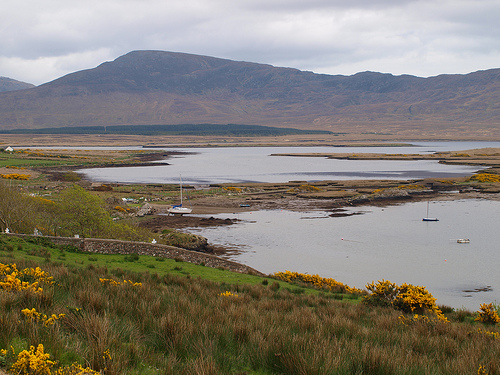
Ballycroy National Park, officially known as Wild Nephin National Park since its expansion and rebranding in 2017, is Ireland's sixth national park and one of its most remote and pristine wilderness areas. Located on the western seaboard in northwest County Mayo, it lies along the Atlantic coast, approximately 1 km from Newport village off the N59 road, with the village of Ballycroy serving as a key access point. The park encompasses 15,000 hectares (150 km² or about 37,000 acres), making it the third-largest national park in Ireland after Wicklow Mountains and Killarney. This vast, uninhabited expanse is dominated by the Nephin Beg mountain range to the east and the expansive Owenduff Bog to the west, forming a dramatic mosaic of blanket bogs, rugged mountains, heathlands, rivers, and lakes. It represents one of the largest intact Atlantic blanket bog systems in Western Europe and includes the most remote point on the Irish mainland, contributing to its reputation as Ireland's loneliest wilderness. The park's boundaries integrate the original Ballycroy section (focused on the bog) with the added Nephin Forest area, creating a contiguous protected zone that buffers against human development and supports rewilding efforts.
The geology of Wild Nephin National Park is shaped by ancient processes dating back to the Ice Age, with the landscape primarily composed of metamorphic rocks such as quartzite and schist in the Nephin Beg Mountains, overlain by deep peat deposits in the lowlands. The standout feature is the Atlantic blanket bog, which covers much of the park's western section and is one of the largest and most intact examples in Europe, spanning about 150 square kilometers. These bogs formed over the last 5,000-10,000 years in a cool, wet oceanic climate, where persistent rainfall (averaging 2,000-3,000 mm annually) exceeds evaporation, leading to waterlogged conditions that promote peat accumulation from decomposed sphagnum moss and other vegetation. Peat depths here can reach up to 7 meters in places, creating a spongy, undulating terrain pockmarked with pools, hummocks, and erosion channels. The bogs are "active," meaning they continue to grow and sequester carbon, playing a crucial role in global climate regulation as a significant carbon sink. Evidence of ancient pine forests, preserved as stumps in the bog and along shores (visible on trails like the Claggan Mountain Coastal Trail), indicates a shift from wooded landscapes to open bog due to climatic changes and human activity over millennia. In the eastern parts, the geology transitions to steeper, rocky slopes with glacial features like corries (cirques) and U-shaped valleys carved by Pleistocene ice sheets. The park's soils are predominantly acidic peaty podsols, supporting hardy vegetation adapted to nutrient-poor conditions.
The park's topography is diverse, ranging from sea-level coastal fringes to upland peaks exceeding 700 meters. The Nephin Beg Mountains form the backbone, a rugged range running north-south with summits like Slieve Carr (721 m, the highest point), Nephin Beg (627 m), and Birreencorragh (698 m), offering sweeping views of the Atlantic Ocean, Achill Island to the west, and the Mullet Peninsula. These mountains are characterized by steep cliffs, rocky outcrops, and heath-covered slopes, with alpine heath and upland grasslands dominating higher elevations. To the west, the terrain flattens into the expansive Owenduff Bog, a sea of rolling blanket bog interspersed with small lakes and meandering streams, creating a sense of infinite openness under vast skies. The park's eastern extension includes Nephin Forest, a 4,000-hectare area of former conifer plantations (lodgepole pine and spruce) now undergoing rewilding to restore native broadleaf woodlands. Coastal elements along the western edge feature dramatic cliffs and estuaries, with the Atlantic influencing erosion and sediment deposition. Overall, the terrain is largely trackless and boggy, making navigation challenging without boardwalks or trails, which enhances its wild, isolated feel.
Hydrology is integral to the park's geography, with the Owenduff River serving as a central artery—the only river in Western Europe that drains a relatively intact blanket bog system. This river, renowned for salmon and sea trout fishing, originates in the mountains and winds through the bog before emptying into Tullaghan Bay on the Atlantic coast, forming a catchment that supports diverse aquatic habitats. Numerous smaller streams and rivulets crisscross the bogs, feeding into peat pools and loughs (lakes) such as Lough Feeagh and Lough Furnace to the south. The high rainfall and impermeable peat lead to frequent flooding and waterlogged conditions, creating a network of wetlands that are vital for water purification and flood mitigation. Coastal influences include estuaries and bays, where freshwater meets the sea, fostering brackish ecosystems.
The park hosts a rich array of habitats, from blanket bogs and wet heaths in the lowlands to montane grasslands and cliffs in the uplands. The blanket bogs support specialized flora like sphagnum mosses, sundews, and butterworts, alongside rare mosses such as Hamatocaulis vernicosus. Mountainous areas feature alpine heath with heathers, bilberry, and crowberry, providing breeding grounds for birds like golden plover and red grouse. River and lake habitats harbor otters, salmon, and migratory birds, including protected species under the EU Birds Directive such as Greenland white-fronted geese, whooper swans, and peregrine falcons. The rewilding of Nephin Forest aims to transition from monoculture plantations to diverse native woodlands, enhancing biodiversity. As part of the Natura 2000 network and a candidate Special Area of Conservation (Owenduff/Nephin Complex), the park's ecosystems are of international importance for carbon storage, water quality, and rare species preservation.
The park's geography is profoundly influenced by its Atlantic location, resulting in a mild, hyper-oceanic climate with high winds, frequent rain, and mild temperatures (averages 5-10°C in winter, 12-18°C in summer). This wet environment sustains the bogs but also leads to erosion and dynamic weather patterns, with "big skies" that shift dramatically from stormy to clear. The remote setting minimizes light pollution, earning it Gold Tier International Dark Sky Park status in 2016—the first in Ireland—ideal for stargazing with views of the Milky Way and meteor showers. Environmental challenges include peat erosion from overgrazing and climate change, but conservation efforts focus on habitat restoration to maintain this unique wilderness.
Ballycroy’s ecological importance stems from its diverse
habitats, which support a range of rare and specialized species.
Flora
Bog Vegetation: The blanket bog is dominated by
sphagnum mosses, which create the acidic, waterlogged conditions
typical of peatlands. Other plants include heather (Calluna
vulgaris), bog cotton (Eriophorum species), and sundews
(Drosera), which are carnivorous plants adapted to nutrient-poor
soils.
Wetland and Grassland Species: In wetter areas,
species like purple moor-grass (Molinia caerulea) and bog
asphodel (Narthecium ossifragum) thrive. The park also supports
rare orchids and sedges.
Woodland and Scrub: Though limited,
small pockets of native woodland feature species like birch,
willow, and rowan.
Fauna
Birds: Ballycroy is a haven
for birdlife, with species like the red-throated diver, merlin,
golden plover, and Greenland white-fronted goose. The park’s SPA
designation highlights its role as a breeding and wintering
ground for these birds. The elusive corncrake, a globally
threatened species, is occasionally heard in surrounding areas.
Mammals: Red deer, Ireland’s largest land mammal, roam the
uplands. Other mammals include otters, badgers, pine martens,
and the Irish hare. The bog’s inaccessibility provides a refuge
for these species.
Amphibians and Reptiles: The common frog
and viviparous lizard are present, thriving in the wet bog
environment.
Invertebrates: The bog supports unique insects,
including the large heath butterfly and dragonflies like the
black darter. The rare marsh fritillary butterfly is also found
in some areas.
Ballycroy has a rich cultural heritage tied to the land and its
people:
Human History: Archaeological evidence, such as
megalithic tombs and stone walls, indicates human activity in
the region dating back to the Neolithic period (circa 4000 BCE).
The park area was historically used for grazing and
turf-cutting, though these activities are now regulated to
protect the bog.
Gaelic Heritage: The park lies in a
Gaeltacht region, where Irish (Gaelic) is still spoken. Local
place names, such as “Owenduff” (meaning “black river”), reflect
this linguistic heritage.
Famine Legacy: The Great Famine
(1845–1852) devastated Mayo, and abandoned settlements in the
park’s vicinity serve as poignant reminders of this period. The
park’s visitor center explores this history through exhibits.
Traditional Practices: Turf-cutting, once a common practice for
fuel, has shaped the bog’s edges. The park balances conservation
with respect for local traditions, though mechanized cutting is
restricted.
Ballycroy’s ecosystems are fragile, and conservation is a
priority:
Threats: Overgrazing, drainage, and climate
change pose risks to the bog’s integrity. Peat extraction,
though reduced, has historically damaged boglands. Invasive
species like rhododendron also threaten native flora.
Conservation Efforts: The National Parks and Wildlife Service
(NPWS) manages the park, focusing on habitat restoration,
monitoring species, and limiting human impact. The park’s SAC
and SPA statuses ensure strict protections under EU law.
Climate Role: Blanket bogs are significant carbon sinks, storing
vast amounts of carbon. Protecting Ballycroy contributes to
global climate change mitigation.
Ballycroy National Park offers a range of activities for visitors,
with facilities designed to educate and minimize environmental impact.
Visitor Center
Location: Situated in Ballycroy village, the
modern visitor center (opened in 2009) serves as the park’s hub.
Features: Interactive exhibits explore the bog’s ecology, local history,
and conservation efforts. A short film provides an overview of the
park’s significance. The center also has a café, shop, and picnic areas.
Accessibility: The center is wheelchair-accessible, with guided tours
and educational programs available.
Trails and Activities
Walking Trails: The park offers several marked trails, ranging from easy
to challenging:
Claggan Mountain Coastal Trail: A short, accessible
boardwalk trail near the visitor center, ideal for families and offering
bog and mountain views.
Tóchar Daithí Bán Trail: A moderate 6 km loop
showcasing bog pools, heather, and birdlife.
Bangor Trail: A
challenging 36 km linear route through the Nephin Beg Range, connecting
to the village of Bangor Erris. It’s suitable for experienced hikers due
to its remote, unmarked sections.
Guided Tours: Rangers lead seasonal
walks, focusing on ecology, birdwatching, or cultural history.
Cycling: The Great Western Greenway, a 42 km off-road cycling trail,
passes near the park, offering scenic routes through Mayo’s countryside.
Stargazing: Ballycroy is part of the Mayo Dark Sky Park, one of the best
places in Ireland for stargazing due to minimal light pollution. The
visitor center hosts dark sky events.
Practical Information
Access: The park is free to enter, with the visitor center open
year-round (hours vary seasonally). The nearest towns are Mulranny and
Bangor Erris, with public transport limited—driving is recommended.
Weather: The park’s Atlantic location means wet, changeable weather.
Visitors should bring waterproof clothing and sturdy boots, especially
for bog trails.
Safety: Remote areas like the Bangor Trail require
preparation, including maps, GPS, and informing others of plans. Mobile
coverage is patchy.
Ballycroy is one of only six national parks in Ireland, and its blanket bog is part of a rare ecosystem found in few places globally, such as Scotland, Newfoundland, and parts of Scandinavia. Its designation as a Ramsar Wetland Site underscores its international importance for wetland conservation. The park also contributes to Ireland’s commitments under the EU Habitats Directive and the Paris Agreement by protecting carbon-rich peatlands.
Best Time to Visit: Spring (April–May) for wildflowers and breeding
birds, or autumn (September–October) for quieter trails and vibrant bog
colors. Winter offers stark beauty but can be harsh.
What to Bring:
Binoculars for birdwatching, a camera for landscapes, and layers for
unpredictable weather.
Respect the Environment: Stick to marked
trails to avoid damaging the bog, and follow the Leave No Trace
principles.
Combine with Nearby Attractions: Explore Achill Island,
Clew Bay, or the Wild Nephin Wilderness Area for a broader Mayo
experience.