Location: Drimoleague, County Cork
Constructed: 16th century
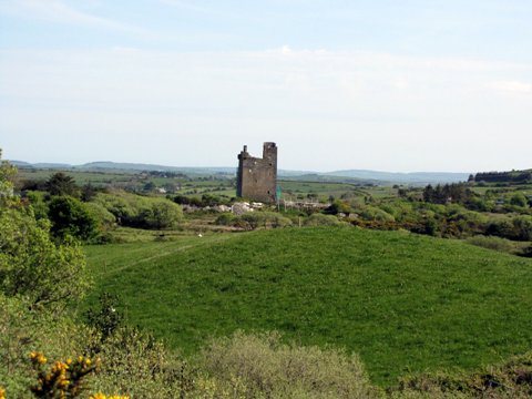
Castle Donovan, also known as Castledonovan or O’Donovan’s Castle (Irish: Caisleán Uí Dhonnabháin), is a 16th-century tower house located in a valley near Drimoleague, County Cork, Ireland. This historic ruin, perched on a rocky outcrop overlooking the River Ilen, was the principal seat of the Clann Cathail sept of the O’Donovan clan during the 16th century. Named Sowagh (or variations like Sooagh/Suagh) before the 17th century, it became known as Castle Donovan after a regrant from James II of England in 1615. Standing approximately 60 feet tall, the castle is a striking example of Irish medieval architecture, despite damage from Cromwellian forces in the 1640s and subsequent centuries of neglect.
The O’Donovan clan, descendants of the Uí Fidgenti from County Limerick, were expelled from their original territory near Kilmallock in the late 12th century by the Fitzgeralds and rival families. They resettled in West Cork, where they established the territory of Carbery, encompassing the manors of Castledonovan and Rahine. The clan’s ancestor, Crom O’Donovan, built a castle on the River Maigue, and his descendant Cahil drove out the O’Driscolls to claim 67 ploughlands, forming the Clann Cathail sept. Castle Donovan was constructed around 1560 by Donal of the Hides (Dónall na g-Croiceann), so named because his mother wrapped him in animal skins as an infant to hide him from enemies. The castle served as a stronghold to guard the northern border of the sept’s lands.
Construction and Early Use (1560–1584): Donal of the Hides, Lord of
Clancahill, built or augmented Castle Donovan around 1560 to secure the
O’Donovan territory. The castle was the clan’s principal residence
during this period, overseeing 67 townlands near Drimoleague, Drinagh,
and Myross. Donal died in 1584, succeeded by his son, Donal II.
English Control and Regrant (1592–1615): In 1592, Donal II surrendered
the castle to the English Crown as part of the surrender and regrant
policy, a tactic to secure land tenure under English law. It was
regranted to him in 1612, and he made repairs or alterations in the
1620s, though the clan had begun shifting to Rahine Manor by the early
17th century. The name “Castle Donovan” emerged after a 1615 regrant
from James II, reflecting the Manor of the Castle of O’Donovan.
Cromwellian Attack (1649): During the Irish Confederate Wars, Donal III
O’Donovan sided with the Stuarts and participated in the 1641 rebellion.
In retaliation, Cromwellian forces attacked Castle Donovan in 1649.
After the defenders ran out of ammunition and escaped by night, the
castle was severely damaged, reportedly blown up with gunpowder. The
assault marked the end of its use as a residence and led to the eventual
collapse of the southern wall. The manor was forfeited for the
O’Donovans’ royalist allegiance and granted to Lieutenant Nathaniel
Evanson after the Restoration, though a portion of Rahine Manor was
later restored to Donal IV.
Later History and Decline: By the late
17th century, the castle was uninhabited. In 1834, Philip Dixon Hardy
described the “vale of Castle Donovan” as “wild, desolate, [and]
lonely,” noting that several outbuildings were still visible in 1828. A
southwest corner collapse in 1936 further destabilized the structure,
leaving large cracks in the masonry. The castle remained neglected until
conservation efforts began in the 21st century.
Castle Donovan is a typical Irish tower house, a fortified residence
common in the 15th and 16th centuries. Rectangular and four stories
tall, it measures 61 feet high, 47 feet long, and 26 feet wide, with
walls 6 feet thick. Built on a solid rocky outcrop, it faces south,
overlooking the Ilen River and the surrounding valley.
Exterior:
The castle’s imposing silhouette is set against the rugged West Cork
mountains. It features a well-defined parapet at the top, typical of
tower houses, and a gothic-arched limestone entrance on the west gable,
originally secured with a heavy oak door. The structure sits on a
natural rock foundation, with the ground floor integrated into the
outcrop.
Interior: The tower was divided into various chambers,
including a food store for the garrison and a room for gunpowder and
shot. A spiral stone staircase in a corner provides access to the four
stories, though it is now gated for safety. The interior includes
impressive fireplaces on the upper floors, visible from the entrance
foyer. The ground floor has a small hallway, but most of the tower is
inaccessible due to structural instability.
Surroundings: The castle
was once enclosed by a bawn (a defensive courtyard wall) and
outbuildings, which are now gone. A rare archaeological feature, a
medieval cereal-drying kiln, is located west of the tower. This
structure, contemporary with the castle, includes a fire-pit and a
capstone to protect drying grain from weather.
Condition: The castle
is a ruin, with significant damage from the Cromwellian attack and the
1936 collapse of the southwest corner. Conservation by the Office of
Public Works (OPW) between 2001 and 2014 stabilized the structure, and
it is now a listed National Monument. Visitors can enter the foyer to
view the staircase and lower room (both gated), but the upper floors are
inaccessible.
Castle Donovan is a symbol of the O’Donovan clan’s legacy in West
Cork, reflecting their resilience and adaptation through centuries
of conflict. The clan’s history, from their Limerick origins to
their prominence in Carbery, underscores their role in Gaelic
Ireland. The castle’s story is tied to broader Irish history,
including the Tudor conquest, Cromwellian wars, and the decline of
Gaelic lordships.
Clan Legacy: The O’Donovans were allied
with families like the O’Mahonys, MacCarthy Reaghs, and O’Learys,
and their territory included key ports like Castlehaven and
Glandore. Notable O’Donovans include Jeremiah O’Donovan Rossa, a
19th-century Fenian, and Marion Donovan, inventor of the disposable
diaper. The castle remains a focal point for O’Donovan clan
gatherings, with a 2000 event prompting government commitment to its
restoration.
Tourism: Castle Donovan is a draw for history
enthusiasts and those tracing O’Donovan ancestry, particularly Irish
Americans. Located on the R586 between Dunmanway and Bantry, it is
signposted from Drimoleague and easily accessible. The surrounding
area offers scenic walks, such as the Castle Donovan and
Mullaghmesha Loop (6.8 miles, moderately challenging), part of St.
Finbarr’s Way. The castle’s grounds are ideal for picnics, and
nearby attractions include the Drimoleague Heritage Walkways and
Sheep’s Head Way.
Community Challenges: In 2023, the O’Donovan
clan faced difficulties organizing a gathering due to a €6 million
insurance policy required by the OPW for site access, highlighting
tensions between public access and preservation.
Castle Donovan is reputedly haunted, with local legends adding to its mystique. One tale claims the castle is cursed by a Braon Sinnsear (“constant drop”), a supernatural phenomenon linked to an act of injustice by the O’Donovans. According to tradition, Daniel O’Donovan and Teige-an-Duna MacCarthy hanged Dorothy Forde from the tower to avoid repaying debts to her family. The curse, manifested as a persistent drip, is said to continue until the O’Donovan line is extinct. While such stories may be folklore, they enhance the castle’s eerie atmosphere, making it a point of interest for those drawn to Ireland’s haunted heritage.
Following OPW conservation from 2001 to 2014, Castle Donovan is
stable but remains a ruin. The site, covering approximately three acres,
was listed for sale in 2024 for €200,000, marketed as a unique
opportunity for those with O’Donovan ties or an interest in Irish
heritage. The castle is freely accessible, though visitors are warned to
exercise caution due to its unguided nature and structural risks.
Access: Located at coordinates 51°41’35.60″ N, 9°16’55.44″ W, the
castle is 6 km north of Drimoleague. Parking is available near the site
or at the nearby brook. The grounds are clean and maintained, with
information boards detailing the castle’s history.
Visitor
Experience: Visitors can explore the grounds, view the cereal-drying
kiln, and enter the foyer to see the staircase and fireplaces. The
castle’s setting, framed by the Ilen River and Mullaghmesha Mountain, is
ideal for photography. Tripadvisor reviews praise its historical charm
and accessibility, with some enjoying nearby walks to Deelish Cascade or
rope swings by the river bridge.
Safety and Recommendations: The OPW
advises care due to the castle’s ruinous state. Hiking boots are
recommended for the surrounding trails, which can be muddy after rain.
Bring water and food, as there are no facilities on-site. Check weather
forecasts, as the area can be exposed.