Location: 14 kms West from Dingle Map
Constructed: Iron Age
Official site
Dunbeg Promontory Fort, also known as An Dún Beag, is a prehistoric coastal fortification located on the Dingle Peninsula in County Kerry, Ireland, near the village of Fahan along the Slea Head Drive, part of the Wild Atlantic Way. Dating to the Late Bronze Age or Iron Age (c. 800 BCE), with evidence of use through the early medieval period (c. 8th–10th centuries CE), Dunbeg is one of Ireland’s best-preserved promontory forts, offering a remarkable glimpse into ancient defensive architecture and settlement patterns. Perched dramatically on a sheer cliff above the Atlantic Ocean, the fort is renowned for its sophisticated stone defenses, including a massive rampart, souterrain, and clocháns (beehive huts). Its strategic coastal location and archaeological significance make it a key site for understanding Ireland’s prehistoric past, while its scenic setting attracts tourists and researchers alike. Managed by the Office of Public Works (OPW), Dunbeg is part of a broader archaeological landscape on the Dingle Peninsula, though it faces ongoing threats from coastal erosion.
Dunbeg’s history spans millennia, reflecting Ireland’s prehistoric
and early medieval periods:
Late Bronze Age/Iron Age (c. 800
BCE): Dunbeg was likely constructed during the Late Bronze Age or early
Iron Age, based on radiocarbon dating of charcoal from the site’s
rampart (c. 800 BCE). Promontory forts, built on coastal headlands, were
common defensive structures during this period, used by tribal
communities to protect against raids and control maritime routes.
Dunbeg’s builders are unknown, but they were likely a local Celtic or
pre-Celtic group, possibly ancestors of the Corcu Duibne, a Gaelic
people associated with the Dingle Peninsula.
Early Medieval Period
(8th–10th Centuries CE): Archaeological evidence, including a souterrain
and clocháns, suggests continued use during the early medieval period,
possibly by Christian monks or local chieftains. The souterrain, a
subterranean passage, is typical of early medieval ringforts and
promontory forts, used for storage or refuge. The clocháns indicate
habitation, aligning with the monastic and secular settlements common in
Kerry at this time, such as those at nearby Gallarus Oratory.
Viking
Era: Dunbeg’s coastal position made it a potential target for Viking
raids (9th–10th centuries), though no direct evidence of Viking activity
has been found. Its defenses suggest it was built to withstand such
threats, controlling access to Dingle Bay.
Post-Medieval Period: The
fort fell out of use by the medieval period, likely replaced by stone
castles like those of the Fitzgeralds (Earls of Desmond) in Kerry. By
the 19th century, Dunbeg was a ruin, noted by antiquarians for its
archaeological value. Excavations in 1977 by Trinity College Dublin, led
by T.B. Barry, revealed its multi-period use and sophisticated
construction, cementing its status as a key prehistoric site.
Modern
Era: Dunbeg was taken into state care by the OPW in the 20th century and
opened to the public as a heritage site. A visitor center, built across
the road, provides interpretive information, though the fort’s cliffside
location faces ongoing erosion, prompting conservation efforts to
stabilize the site.
Dunbeg Promontory Fort is a masterfully engineered structure,
leveraging its cliffside location for defense and incorporating
sophisticated stonework typical of Ireland’s prehistoric and early
medieval fortifications. Built primarily from local sandstone, the
fort’s design maximizes natural topography while showcasing advanced
construction techniques. Key architectural elements include:
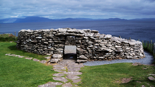
Promontory Setting and Rampart:
Dunbeg occupies a triangular
promontory, isolated by sheer cliffs dropping 20–30 meters to the
Atlantic on three sides. This natural barrier made the fort nearly
impregnable from the sea, with access restricted to a narrow
landward approach.
A massive stone rampart, approximately 8
meters thick and 3.5 meters high, defends the landward side, forming
a crescent-shaped barrier across the promontory’s neck. The rampart,
constructed around 800 BCE, is dry-stone built (no mortar) with a
double-faced wall filled with rubble and earth. It features four
parallel walls and three fosses (ditches), creating a multi-layered
defense system to deter attackers.
The rampart includes an
internal passage, 8 meters long, 1 meter wide, and 2 meters high,
with a lintelled roof, possibly used for storage or as a defensive
lookout. The passage’s precise construction highlights the builders’
engineering skill.
Entrance and Defenses:
The main
entrance is a narrow, lintelled passageway through the rampart,
flanked by upright stones and a gatepost socket, suggesting a wooden
gate. The passage’s restricted width (about 1 meter) forced
attackers into a bottleneck, easily defended by archers or spearmen.
External and internal ditches, up to 2 meters deep, enhance the
rampart’s defensibility, creating obstacles for assailants. The
ditches were likely supplemented by wooden palisades, now lost.
A
chevaux-de-frise, a field of upright stones outside the rampart, may
have existed to impede attackers, though erosion has obscured
evidence.
Souterrain:
Within the fort’s interior, a
souterrain (underground passage) dating to the 8th–10th centuries CE
measures 16 meters long, with a corbeled stone roof and a narrow,
creeping entrance. The souterrain, accessed via a trapdoor or small
opening, was likely used for storing food (e.g., grain, dairy) or as
a refuge during raids. Its construction aligns with early medieval
practices, seen in ringforts across Ireland.
The souterrain’s
preservation is exceptional, allowing visitors to view its interior
(with caution, due to its confined space).
Clocháns (Beehive
Huts):
The fort contains the remains of four or five clocháns,
corbeled stone huts with circular or oval plans, typical of early
medieval Ireland. These huts, built around the 8th century CE,
served as living quarters, storage, or workshops, possibly for a
small community of monks or farmers.
The largest clochán,
partially reconstructed, has a diameter of about 5 meters and a
domed roof, showcasing the dry-stone technique where stones are
carefully layered to form a self-supporting structure.
Interior and Layout:
The fort’s interior, covering about 0.5
hectares, is relatively small due to the promontory’s narrow shape.
It likely housed a modest community, with space for livestock,
storage, and communal activities.
The cliff edge, now eroding,
originally extended further, suggesting the fort was larger in
antiquity. Archaeological evidence indicates a central hearth and
postholes, pointing to wooden structures or tents within the
enclosure.
Restoration and Stabilization:
The OPW has
stabilized the rampart and clocháns, reinforcing stonework to
prevent collapse. The souterrain has been secured for safety, with
limited access to protect its integrity. Ongoing erosion control
measures, such as sea defenses, aim to slow cliff retreat, though
parts of the fort are at risk of loss to the ocean.
Dunbeg’s strategic significance stems from its coastal location and
formidable defenses:
Coastal Defense: Perched on a cliff above
Dingle Bay, Dunbeg controlled maritime approaches, allowing its
occupants to monitor trade routes, fishing grounds, and potential
invaders, such as Vikings. Its elevated position offered clear
sightlines to the Blasket Islands and Mount Brandon, facilitating early
warning of threats.
Landward Protection: The rampart, ditches, and
narrow entrance made Dunbeg impregnable from the landward side, forcing
attackers into a confined, easily defended approach. The fort’s design
suggests it was built to withstand tribal raids or inter-clan conflicts
common in the Bronze and Iron Ages.
Economic Role: The fort likely
served as a hub for fishing, trade, and pastoral activities, with the
souterrain and clocháns supporting a self-sufficient community. Its
proximity to fertile land and marine resources ensured economic
stability.
Early Medieval Use: The souterrain and clocháns indicate
continued strategic importance in the early medieval period, possibly as
a monastic retreat or chieftain’s outpost, protecting against Viking
raids and securing local influence.
The fort’s isolated yet
commanding position made it a microcosm of power in prehistoric and
early medieval Kerry, controlling both land and sea routes.
Dunbeg Promontory Fort is significant for its archaeological and
cultural contributions:
Prehistoric Engineering: Dating to c. 800
BCE, Dunbeg showcases advanced Bronze/Iron Age construction techniques,
with its multi-layered rampart and internal passage rivaling
contemporary forts in Britain and Europe. Its preservation offers
insight into Ireland’s defensive architecture before the arrival of
stone castles.
Multi-Period Use: The fort’s occupation from the
Bronze Age to the early medieval period (800 BCE–10th century CE)
reflects continuity of settlement on the Dingle Peninsula. The
souterrain and clocháns align with Ireland’s early Christian landscape,
connecting Dunbeg to the region’s monastic heritage, as seen at nearby
sites like Gallarus Oratory and Kilmalkedar.
Archaeological Value:
Excavations in 1977 by Trinity College Dublin, published in The Journal
of the Royal Society of Antiquaries of Ireland, confirmed Dunbeg’s
multi-phase construction and use, with radiocarbon dates anchoring its
timeline. Artifacts like pottery, bone tools, and charcoal provide
evidence of daily life, while the souterrain’s preservation is a rare
find.
Cultural Heritage: Dunbeg embodies the resilience of Ireland’s
prehistoric communities, who thrived in a harsh coastal environment. Its
association with the Corcu Duibne and early Christian monks ties it to
the Gaelic culture of Kerry, while its Wild Atlantic Way prominence
highlights its modern role as a cultural icon.
Dunbeg Promontory Fort is managed by the Office of Public Works as a
National Monument and is open to the public, though its cliffside
location and erosion risks pose challenges:
Access: The fort is
accessible year-round, with a small admission fee (€3–€5, as of 2023;
check heritageireland.ie for updates) that includes entry to the visitor
center across the road (open March–October, 10:00 AM–5:00 PM). Located
on the Slea Head Drive (R559), 8 km west of Dingle Town and 1 km from
Fahan, the fort is a 10-minute drive from Dingle or 2 hours from
Killarney via the N86. Parking is available at the visitor center, which
offers toilets, a café, and a gift shop. Public transport (Bus Éireann
or local shuttles) connects Dingle to Fahan, with a short walk to the
site.
Condition: The fort is well-preserved, with the rampart,
souterrain, and clocháns intact, though coastal erosion has reduced the
promontory’s size, with parts of the cliff edge lost to the sea. The OPW
has installed protective barriers and reinforced stonework, but the site
remains vulnerable. Warning signs caution visitors to stay clear of the
cliff edge due to instability.
Visitor Experience: The visitor center
features an audiovisual presentation (The Stone Fort of Dunbeg)
detailing the fort’s history, archaeology, and the Dingle Peninsula’s
heritage. Guided tours (30–45 minutes, summer only) explore the rampart,
souterrain, and clocháns, with OPW staff explaining construction
techniques and historical context. Self-guided visits allow exploration
of the fort’s interior and cliffside views of the Atlantic, Blasket
Islands, and Mount Brandon. The site is partially accessible for those
with mobility issues, though uneven terrain and the souterrain’s narrow
entrance limit access. The fort’s dramatic setting, with waves crashing
below, is a highlight, especially at sunset, as noted in travel guides
like Lonely Planet.
Nearby Attractions: Dunbeg is part of the Dingle
Peninsula’s archaeological trail, complementing sites like Gallarus
Oratory (5 km), Kilmalkedar Church (6 km), and the Blasket Centre (15
km). Dingle Town offers dining, music, and cultural experiences, while
Slea Head’s cliffs and beaches enhance the fort’s scenic appeal.
Cultural Significance: Dunbeg is a flagship site along the Wild Atlantic
Way, celebrated in tourism campaigns for its ancient allure and coastal
drama. It attracts over 50,000 visitors annually (pre-2020 estimates),
drawn by its archaeological significance and photogenic setting. Local
festivals, such as Dingle’s Féile na Bealtaine, occasionally include
events near the fort, reinforcing its cultural role.
Dunbeg has been extensively studied, with key findings from the 1977
excavations by Trinity College Dublin, led by T.B. Barry:
Excavations: The 1977 dig focused on the rampart, souterrain, and
clocháns, uncovering charcoal dated to c. 800 BCE, confirming the fort’s
Bronze Age origins. Pottery, bone tools, and a central hearth suggest
domestic activity, while the souterrain’s 8th–10th-century construction
indicates later use. The rampart’s internal passage and multi-layered
design were mapped, revealing engineering sophistication.
Ongoing
Research: The NPWS and University College Cork monitor the site for
erosion impacts, using LiDAR and geophysical surveys to map subsurface
features without invasive digging. The souterrain’s preservation has
drawn comparisons to similar structures at Caherconnell and Dowth.
Publications: Findings are published in The Journal of the Royal Society
of Antiquaries of Ireland (1978) and The Archaeology of the Dingle
Peninsula by Judith Cuppage (1986). The OPW’s visitor center provides
summaries, ensuring public access to research.
Challenges: Coastal
erosion, accelerated by climate change, threatens the fort’s cliff edge,
prompting studies on stabilization. Artifacts are housed in the National
Museum of Ireland, with replicas displayed at the visitor center.
Dunbeg features in local folklore as a stronghold of ancient warriors
or monks, with tales linking it to the mythical Fianna or early
Christian hermits. Its dramatic cliffside setting has inspired artists,
such as Paul Henry, whose paintings capture the Dingle Peninsula’s
rugged beauty, and photographers like those featured in National
Geographic Traveler. Travel blogs, including The Irish Road Trip and
Discover Ireland, praise Dunbeg as a “must-see” for its ancient aura and
Atlantic views, with Reddit posts on r/ireland highlighting its
photogenic appeal (e.g., 300–500 upvotes for Slea Head photos).
The fort appears in documentaries, such as RTÉ’s The Secrets of the
Irish Landscape, which explores its prehistoric significance, and is
referenced in literature about Ireland’s Celtic past, though less
prominently than medieval castles. Its role in the Wild Atlantic Way and
Dingle’s tourism narrative underscores its modern cultural status, with
hashtags like #DunbegFort trending on social media.