Location: Kanturk, Province of Munster Map
Constructed: 1609
Kanturk Castle, known locally as “The Old Court” or “Carrig-na-Shane-Saor” (The Rock of John the Mason), is a striking fortified house located approximately 1.5 kilometers south of the market town of Kanturk in the Blackwater Valley, County Cork, Ireland. Built around 1601 for Dermot MacDonagh MacCarthy, Lord of Duhallow, this imposing structure blends Irish tower house traditions with Tudor and Renaissance architectural influences, reflecting the ambitions of a Gaelic chieftain during a period of political and cultural transition. Never fully completed, the castle stands as a roofless ruin, yet its well-preserved stonework and historical significance make it a compelling National Monument managed by An Taisce (The National Trust for Ireland).
Origins and Construction
Kanturk Castle was commissioned by Dermot
MacDonagh MacCarthy, a chieftain of the MacCarthy clan and Lord of
Duhallow, around 1601, with construction likely spanning several years,
possibly until 1618. The MacCarthys, a powerful Gaelic dynasty with a
thousand-year lineage as Kings of Munster, had been displaced from
southern counties like Kilkenny and Tipperary by Norman forces in the
13th century. They established a stronghold in the fertile Blackwater
Valley, where Kanturk became a key settlement. The castle was intended
as MacCarthy’s chief residence and a defensive fortress to assert Gaelic
authority against encroaching English settlers during the late
Elizabethan era, following the Gaelic defeat at the Battle of Kinsale
(1601).
The castle’s construction was a bold statement of wealth
and power, funded partly by mortgaging MacCarthy’s lands to English
financiers. However, it was never completed, and two primary theories
explain this:
Privy Council Intervention: According to legend,
the English Privy Council, alarmed by the castle’s scale and potential
as a Gaelic stronghold, ordered construction to halt, fearing it could
be used to attack English settlers. Enraged, MacCarthy allegedly smashed
the blue ceramic roof tiles and threw them into a nearby stream, which
became known as the Bluepool Stream due to their reflection.
Financial Ruin: An alternative theory suggests MacCarthy exhausted his
funds, unable to borrow further from English moneylenders, leaving the
project incomplete. The absence of a bawn (defensive wall) and
machicolated parapet supports this view.
A prophecy by MacCarthy’s
stepbrother, MacAuliffe, a seer, claimed the castle was “too fine a home
for crows” and would never be finished, adding a mystical layer to its
history. Local folklore also attributes the nickname
“Carrig-na-Shane-Saor” to seven stonemasons, all named John, who worked
on the castle, and claims “blood in the mortar” (possibly animal blood
used to strengthen lime or a reference to laborer deaths) taints its
walls.
Post-Construction and Ownership
The castle was likely
occupied briefly by the MacCarthys until 1641, when Dermot Oge
MacCarthy, Dermot’s grandson, mortgaged it to Sir Philip Perceval, an
English Protestant, due to financial difficulties from funding
rebellions and castle upkeep. Perceval stripped the castle of fixtures,
including fireplaces, for use in other properties, such as Lohort
Castle. The Perceval family, later Earls of Egmont, retained ownership
for centuries, though the castle remained uninhabited and unroofed.
In 1652, Dermot Oge and his son were killed during a Cromwellian
battle, and after the Confederate Wars, the Lordship of Duhallow and
Kanturk Manor were awarded to Perceval. The Percevals, prominent
Anglo-Irish landowners, included notable figures like Spencer Perceval,
the only British Prime Minister assassinated (1812). In 1900, Lucy,
Countess of Egmont, widow of the 7th Earl, donated the castle to the
National Trust (UK) on the condition it remain a ruin, making it the
Trust’s ninth property and its only holding in the Republic of Ireland
for much of the 20th century. In 2000, following amended UK legislation,
ownership was transferred to An Taisce, with President Mary McAleese
accepting the deeds in a ceremony at the castle.
Cultural Context
Kanturk Castle reflects the transition from Gaelic to Anglo-Irish
dominance in Ireland. Built during a period of relative peace but
increasing English control, it symbolizes Gaelic resistance and
adaptation to European architectural trends. Its incomplete state
underscores the economic and political pressures faced by Gaelic lords
in the early 17th century, caught between rebellion and assimilation.
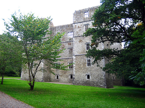
Kanturk Castle is a remarkable example of a fortified house,
blending traditional Irish tower house features with Tudor and
Renaissance influences, making it one of Ireland’s largest and most
architecturally significant structures of its kind. Constructed from
limestone rubble sourced from a nearby quarry, the castle measures
28 meters long by 11 meters wide, with a rectangular main block
rising four stories and four corner towers reaching five stories (29
meters high).
Exterior Features
Structure: The castle is a
roofless shell with a rectangular layout and massive square towers
at each corner, giving it a formidable silhouette. The towers,
slightly projecting, add defensive and aesthetic grandeur.
Main
Entrance (Northwest Side): A Renaissance-inspired doorway on the
first floor, accessed by a now-crumbling grand staircase, features
Ionic columns and a neoclassical pediment, though not a true
neoclassical design. This entrance reflects continental influences,
rare in Gaelic architecture.
Secondary Entrance (Southeast Side):
A smaller, pointed-arch doorway at ground level, typical of Irish
tower houses, includes gun loops for defense, highlighting the
castle’s dual role as residence and fortress.
Windows: The ground
floor features flat “Burgundian” arches, while upper floors have
Tudor-style mullioned windows (two or three mullions), allowing
ample light and showcasing wealth. The large windows suggest a
residential rather than purely defensive purpose.
Battlements and
Corbels: Surviving corbels indicate an intended machicolated
parapet, but the absence of battlements confirms the castle’s
incomplete state.
Interior Features
Layout: The interior
is hollow, with timber floors and walls long gone, leaving a vast
stone shell. The main block’s four stories and the towers’ five
stories are discernible through window placements and fireplace
locations.
Fireplaces: A remarkable number of well-preserved
fireplaces, crafted with fine stone masonry, line the walls, with
the grandest on the fourth floor, featuring intricate corbels and
mouldings. These fireplaces, some stripped by Perceval, highlight
the castle’s intended opulence.
Stonework: Pointed arches,
corbels, and window frames showcase skilled craftsmanship, blending
Irish and European styles. The contrast between the Renaissance
north entrance and the traditional south doorway illustrates the
castle’s architectural hybridity.
Architectural Significance
Kanturk Castle is unique for its fusion of styles: the defensive
elements of an Irish tower house (gun loops, corner towers) coexist
with Tudor and Renaissance features (mullioned windows, neoclassical
doorway), reflecting the MacCarthys’ engagement with contemporary
British and continental trends. Its size and design made it a
“highly fashionable building,” linking Ireland to broader European
architectural developments.
Kanturk Castle is a poignant symbol of Ireland’s 17th-century
upheavals, embodying:
Gaelic Ambition: As the “finest castle
built by a Celtic family in Ireland,” it reflects the MacCarthys’ desire
to assert power and prestige in a changing political landscape.
Legends and Folklore: The Bluepool Stream tale, the prophecy of
MacAuliffe, and the “blood in the mortar” story enrich the castle’s
mystique, connecting it to local oral traditions.
Heritage Tourism:
The castle attracts visitors tracing familial roots, particularly from
the McCarthy, McAuliffe, O’Keeffe, O’Callaghan, and other clans linked
to the region post-Siege of Kinsale.
National Monument Status: Its
designation as a National Monument and transfer to An Taisce underscore
its importance to Ireland’s heritage, paralleling the development of the
heritage trust movement.
The castle’s never-besieged status and
peaceful, non-strategic location add to its enigma, suggesting it was as
much a status symbol as a defensive structure.
Kanturk Castle is a free, unguided attraction managed by the Office
of Public Works (OPW) and An Taisce, open year-round. Its serene setting
and historical allure make it a hidden gem in North Cork.
Access:
Located 1.5 km south of Kanturk town, off the N72 (Mallow-Killarney
road), the castle is easily accessible by car, with parking available
just outside the grounds. Public transport options include buses to
Kanturk from Mallow or Cork, with Banteer railway station 6 km away.
From Kanturk town center, it’s a 20-minute walk or short taxi ride.
Exploration: Visitors can freely wander the castle’s exterior and
interior, though caution is advised due to uneven surfaces and the lack
of guided tours. Informational placards provide historical context,
covering the castle’s construction, legends, and ownership. The visit
typically takes 20–30 minutes, ideal for a quick stop or leg-stretch
during a road trip.
Highlights:
Admire the
Renaissance-inspired main entrance and contrast it with the pointed-arch
secondary door.
Explore the interior to see preserved fireplaces,
especially the grand fourth-floor example, and imagine the castle’s
intended grandeur.
Enjoy the wooded grounds, with an avenue of trees
and the nearby Dalua River, offering a peaceful setting for photography
or relaxation.
Note the castle’s nighttime illumination, enhancing
its dramatic presence.
Nearby Attractions:
Kanturk Town:
Features Georgian architecture, riverside parks, and cultural events
like the Wild Boar Festival and Kanturk Arts Festival. The town’s
library and Edel Quinn Hall host community activities.
Knocknakilla
Stone Circle: A Bronze Age site 10 km away, offering a glimpse into
prehistoric Ireland.
Doneraile Wildlife Park: 20 km away, with
walking trails and deer herds.
Glanworth Wedge Tombs and Fermoy:
Within 30 km, showcasing prehistoric and riverside heritage.
Best
Time to Visit: Spring (April–May) and summer (June–August) offer
pleasant weather and vibrant greenery, ideal for exploring the grounds.
Early mornings or late afternoons provide optimal lighting for
photography. A rain jacket and sturdy shoes are recommended due to
Ireland’s unpredictable weather and uneven terrain.
Reviews: Visitors
on Tripadvisor (2024) praise the castle’s “beautifully preserved walls,”
“serene energy,” and “spectacular architecture,” noting its
accessibility and free entry. Some describe it as a “fascinating ruin”
and a “must-see” for history buffs, though its hollow interior limits
exploration time.
Recent Developments
Ownership and Management: Since its transfer
to An Taisce in 2000, the castle has been maintained as a National
Monument, with the OPW overseeing its care. Extensive restoration and
stabilization work, initiated in the 20th century, ensures the
structure’s integrity.
Community Engagement: The castle is a focal
point for local pride, with residents using the grounds for walks, yoga
sessions, and dog-walking. Its illumination at night, noted in 2024
reviews, enhances its visibility and appeal.
Heritage Tourism: A 2025
blog post by Secret Ireland highlights the castle’s growing popularity
among history and architecture enthusiasts, emphasizing its legends and
proximity to other Cork attractions.
Conservation Efforts
An
Taisce’s Role: Since acquiring the freehold in 2000, An Taisce has
purchased surrounding land to protect the castle’s setting and conducted
maintenance to preserve its stonework and fireplaces. The castle’s
status as a ruin, per Lucy Egmont’s 1900 condition, is respected, with
no plans to restore it to a habitable state.
OPW Oversight: The OPW
ensures public safety through signage and periodic inspections, though
visitors are warned to exercise caution due to the unguided nature of
the site.
Community Involvement: Local efforts, such as Kanturk’s
voluntary groups, support the castle’s integration into the town’s
cultural life, with events like the Wild Boar Festival celebrating the
area’s heritage.
Challenges
Preservation vs. Ruin Status:
Maintaining the castle as a ruin while preventing further deterioration
requires careful management, especially given its exposure to weather.
Limited Facilities: The lack of guided tours or on-site amenities (e.g.,
restrooms) may deter some visitors, though its free entry offsets this.
Balancing Access and Safety: The OPW emphasizes visitor responsibility,
as the hollow interior and uneven grounds pose risks, particularly for
children or those with mobility issues.