Location: Monkstown Map
Constructed: 12th- 13th century
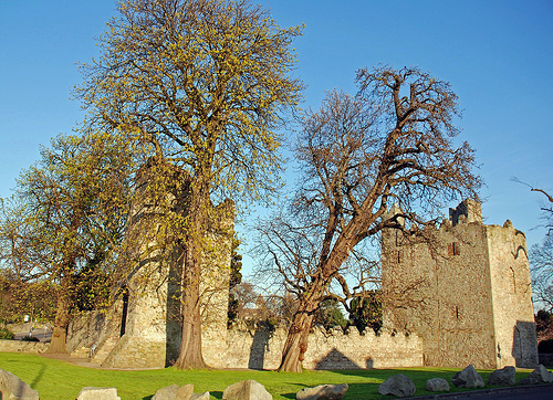
Monkstown Castle, located in Monkstown, County Dublin, Ireland, is a well-preserved medieval castle that stands as a testament to Ireland’s turbulent history and architectural heritage. Situated in a suburban area between Dún Laoghaire and Blackrock, approximately 8 kilometers south of Dublin city center, the castle is a National Monument, recognized for its historical and architectural significance. Built in the 13th or 14th century by the Cistercian monks of St. Mary’s Abbey, Monkstown Castle served as a fortified residence and administrative center during the medieval period. Its strategic location near Dublin Bay, combined with its association with powerful families and religious institutions, makes it a fascinating subject.
Monkstown Castle’s history spans over seven centuries,
reflecting the shifting political, religious, and social dynamics of
Ireland, from its monastic origins to its role in Anglo-Irish governance
and modern preservation.
Monastic Origins (13th–14th Century):
The castle was constructed by the Cistercian monks of St. Mary’s Abbey,
one of Dublin’s most influential religious institutions, likely in the
late 13th or early 14th century. The monks used the castle as a
fortified grange (outlying farm or manor) to manage their extensive
landholdings in the Monkstown area, which was named after their presence
(Baile na Manach in Irish, meaning “Town of the Monks”).
Its location
near Dublin Bay provided access to maritime trade and fishing, while its
fortified design protected against raids by local Gaelic clans and other
threats.
Post-Dissolution and Secular Ownership (1540s–17th
Century):
Following the Dissolution of the Monasteries under Henry
VIII in 1539, St. Mary’s Abbey was suppressed, and its lands, including
Monkstown Castle, were seized by the Crown. The castle was granted to
Sir John Travers, Master of the Ordnance in Ireland, in 1551.
In
1580, the castle passed to Sir Henry Wallop, Vice-Treasurer of Ireland,
and later to the Chevers family, a prominent Anglo-Irish family. The
Chevers, who were Catholic, held the castle through the turbulent 16th
and 17th centuries, including during the Elizabethan conquest and the
Irish Confederate Wars (1641–1653).
During the Cromwellian conquest
(1649–1653), the castle was briefly confiscated but returned to the
Chevers family after the Restoration of Charles II in 1660.
18th–19th Century Decline and Military Use:
By the 18th century, the
castle’s strategic importance diminished as Ireland’s political
landscape stabilized under British rule. The Chevers family continued to
own the estate, but the castle itself was repurposed for agricultural
and residential use, with parts leased to tenants.
In the early 19th
century, the castle was used as a military barracks, reflecting its
robust structure and defensive capabilities. However, by the mid-19th
century, it fell into disrepair as the surrounding area developed into a
residential suburb with the growth of Dún Laoghaire and the arrival of
the railway in 1834.
20th Century and Preservation:
In the
early 20th century, Monkstown Castle was recognized for its historical
value and designated a National Monument, placing it under the care of
the Office of Public Works (OPW). Restoration efforts in the 20th
century focused on stabilizing the structure and preserving its medieval
features.
The castle’s grounds were reduced as suburban development
encroached, but its core structure remained intact, serving as a
reminder of Dublin’s medieval past amidst modern surroundings.
Monkstown Castle is a classic example of a late-medieval Irish
castle, combining elements of a fortified tower house with
residential features. Its architecture reflects the practical needs
of defense and the status of its occupants.
Overall
Structure:
The castle consists of two main towers connected by a
central hall, forming an L-shaped plan, which is unusual for Irish
castles of the period. The towers are rectangular, with the larger
western tower being the primary defensive structure and the eastern
tower serving as a residential wing.
Constructed from local
limestone and granite, the castle’s walls are thick (up to 1.5
meters in places) and designed to withstand attack. The structure
stands approximately 15 meters tall, with three to four stories.
Defensive Elements:
Western Tower: The larger tower features
a bartizan (overhanging turret) at one corner, machicolations
(openings for dropping projectiles), and narrow slit windows for
archers, indicating its defensive purpose. A mural staircase (within
the wall) provides access to upper levels, a common feature in
fortified castles.
Parapets and Battlements: The castle’s
roofline includes stepped battlements, typical of Irish medieval
architecture, offering protection for defenders.
Entrance: The
original entrance, located at ground level, was protected by a heavy
wooden door and possibly a portcullis. A later entrance was added at
the first-floor level, accessed via an external staircase, enhancing
security.
Residential Features:
The eastern tower and
central hall contain larger windows and fireplaces, indicating their
use as living quarters for the castle’s occupants. The hall likely
served as a communal space for dining and administration.
The
upper floors of the western tower include private chambers, with
evidence of vaulted ceilings and decorative stonework, suggesting a
degree of comfort for the castle’s lords.
Later
Modifications:
During the 17th and 18th centuries, the castle was
adapted for residential use, with larger windows inserted and
internal partitions added. Some of these changes were reversed
during 20th-century restorations to emphasize the castle’s medieval
character.
The surrounding bawn (defensive courtyard) and
ancillary buildings, such as stables and kitchens, have largely
disappeared due to urban development.
While Monkstown Castle is not fully furnished or open for extensive
interior tours, its external and limited internal features offer insight
into its medieval design and function.
Western Tower:
The most
imposing part of the castle, the western tower contains a spiral
staircase, guard rooms, and defensive features like arrow slits. The
upper floors likely housed the lord’s private quarters, with fireplaces
and latrines (garderobes) built into the walls.
The bartizan and
machicolations are well-preserved, offering a glimpse into medieval
military architecture.
Central Hall:
The connecting hall
between the towers served as the castle’s main communal space. It
features a large fireplace and traces of a vaulted ceiling, indicating
its use for gatherings and administrative functions.
The hall’s
larger windows, added in later centuries, suggest it was adapted for
comfort as the castle transitioned from a fortress to a residence.
Eastern Tower:
Smaller and more residential in character, the
eastern tower contains additional living spaces, with evidence of
domestic features like storage niches and window seats.
The tower’s
upper levels may have housed family members or high-ranking retainers.
Surrounding Grounds:
The castle originally sat within a bawn, a
walled enclosure typical of Irish castles, which included outbuildings
and a gatehouse. Urban development has replaced the bawn with modern
roads and housing, but a small green area around the castle remains.
A nearby churchyard, associated with the monks and later owners,
contains historical graves, adding to the site’s heritage.
Monkstown Castle, though less visited than Ireland’s more famous
castles, holds significant cultural and historical value as a rare
surviving medieval structure in suburban Dublin.
Historical
Importance:
The castle’s association with St. Mary’s Abbey links it
to Ireland’s monastic tradition, a key aspect of medieval life. Its role
as a grange highlights the economic power of religious institutions
before the Reformation.
Its ownership by Anglo-Irish families like
the Chevers reflects the complex interplay of Gaelic, Norman, and
English influences in Dublin’s history, particularly during the
turbulent 16th and 17th centuries.
Architectural Value:
As one
of the few intact medieval castles in County Dublin, Monkstown Castle is
a valuable example of transitional architecture, bridging the gap
between purely defensive tower houses and more comfortable manor houses.
Its designation as a National Monument underscores its importance to
Ireland’s heritage, with the OPW ensuring its preservation.
Modern Role:
The castle is not a major tourist attraction like
Bunratty or Kilkenny Castle but serves as a local landmark and point of
historical interest. It is occasionally used for community events,
historical reenactments, and educational tours.
Its location in a
residential area makes it a cherished part of Monkstown’s identity, with
locals valuing its presence amidst modern development.
Monkstown Castle is maintained by the Office of Public Works (OPW)
and is accessible to the public, though its interior is not regularly
open for tours due to its state of preservation and limited facilities.
Access and Location:
Location: Monkstown Castle, Monkstown Castle
Farm, Monkstown, County Dublin, Ireland (near the junction of Monkstown
Road and Carrickbrennan Road).
Hours: The castle’s exterior is
accessible year-round during daylight hours. Interior access is limited
to special guided tours or OPW-organized events, typically in summer or
by appointment.
Admission: Free to view from the outside; guided
tours, when available, may have a nominal fee (check with the OPW for
details).
Activities:
Exterior Viewing: Visitors can walk
around the castle’s perimeter, admiring its towers, battlements, and
stonework. Informational plaques provide historical context.
Guided
Tours: Occasional OPW tours allow limited interior access, focusing on
the castle’s architecture and history. These are often part of Heritage
Week or other cultural events.
Photography and Exploration: The
castle’s picturesque setting makes it a favorite for photographers,
especially in spring when surrounding greenery enhances its medieval
ambiance.
Local Walks: The castle is near Monkstown village, with
coastal walks along Dublin Bay and nearby attractions like Dún Laoghaire
Pier offering a broader experience.
Facilities:
There are no
on-site visitor facilities (e.g., restrooms, cafes, or gift shops) due
to the castle’s small size and preservation status. Nearby Monkstown
village offers cafes, pubs, and shops.
The castle’s grounds are
accessible for those with mobility challenges, but the interior, with
its narrow staircases, is not.
Getting There:
By Car: The
castle is a 20-minute drive from Dublin city center via the R118.
Limited street parking is available nearby.
By Public Transport: The
DART (Dublin Area Rapid Transit) stops at Monkstown (Salthill and
Monkstown station), a 5-minute walk from the castle. Buses from Dublin
city center (routes 7, 7A, or 46A) also serve the area.
By Foot/Bike:
The castle is easily reachable on foot or by bike from Dún Laoghaire or
Blackrock, with cycle lanes along Monkstown Road.
Nearby
Attractions:
Dún Laoghaire Pier (2km): A historic pier with scenic
walks and maritime heritage.
James Joyce Tower and Museum (3km): A
Martello tower in Sandycove, featured in Ulysses.
People’s Park, Dún
Laoghaire (2km): A Victorian park with markets and events.
Blackrock
Castle Observatory (5km): A 16th-century castle with a modern science
center.
Monastic Legacy: The castle’s name and origins tie it to St. Mary’s
Abbey, one of Dublin’s wealthiest monasteries, which also controlled
lands as far as Fingal and Kildare.
Chevers Family: The Chevers, who
owned the castle for centuries, were notable for their Catholic loyalty
during penal times, maintaining influence despite religious persecution.
Urban Contrast: Unlike rural castles, Monkstown’s location in a modern
suburb creates a striking juxtaposition of medieval and contemporary
Dublin.
Literary Connections: The castle’s proximity to Dún Laoghaire
and Sandycove links it to the literary heritage of James Joyce, whose
Ulysses is set in the area.
Conservation and Challenges
Preservation: The OPW’s restoration efforts have stabilized the castle’s
structure, repairing stonework and preventing further decay. However,
ongoing maintenance is required due to the castle’s age and exposure to
coastal weather.
Urban Encroachment: Suburban development has reduced
the castle’s historical context, with modern houses and roads replacing
its original bawn and estate. The OPW works to protect the remaining
grounds.
Public Access: Balancing preservation with public access is
a challenge, as the castle’s interior is fragile. Limited tours help
mitigate wear while promoting education.
Climate Impact: Coastal
erosion and rising sea levels near Dublin Bay could pose long-term
risks, prompting monitoring by heritage authorities.