Location: Co Carlow, Dublin, Wicklow, Wexford Map
Area: 3000 km2 (1158 mi2)
Official site
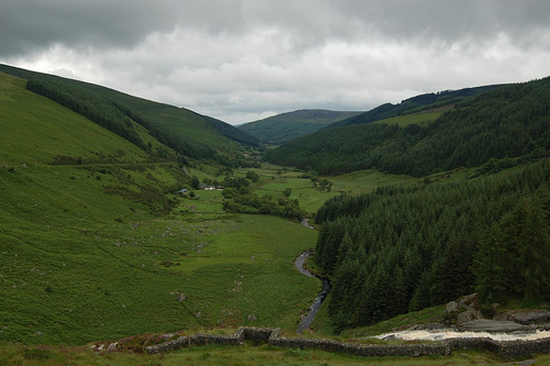
The Wicklow Mountains (Sléibhte Chill Mhantáin in Irish, meaning "Mountains of the Church of Mantán") form a stunning granite mountain range in southeast Ireland, primarily in County Wicklow, with parts extending into Counties Dublin, Carlow, and Wexford. Often referred to as the "Garden of Ireland," this region is renowned for its rugged landscapes, glacial valleys, heather-clad uplands, and rich cultural and historical significance.
Location and Extent
Centered in County Wicklow just south of
Dublin, the mountains lie roughly between 53°04′52″N 6°23′24″W. They
occupy the entire central upland of Wicklow County and spill across
borders. The range is bounded to the north by the Dublin foothills, east
by coastal lowlands and the Vartry Plateau, south by the Blackstairs
Mountains, and west by the Glen of Imaal and lower plains. Key access
points include the historic Military Road (R115) and the R756 through
the Wicklow Gap.
Topography and Major Peaks
The landscape
features a rolling peat-covered plateau (typically 400–700 m)
interspersed with rounded summits, steep-sided glens, and dramatic
U-shaped valleys. There are 39 peaks exceeding 600 m (2,000 ft). The
highest is Lugnaquilla at 925 m (3,035 ft)—the tallest in Leinster and
the only Irish Munro outside Munster—followed by Mullaghcleevaun (849
m), Tonelagee (817 m / often listed as 815 m), and others like Camaderry
and Keadeen. Distinct groups include the northern Kippure massif (757
m), central peaks around Djouce and Tonelagee, western Church and
Keadeen Mountains, and southern Croghan Kinsella. Only three road passes
lie below 600 m, making Sally Gap (498 m) and Wicklow Gap (478 m) among
Ireland’s highest.
Notable outliers east of the main chain (separated
by the Vartry Plateau) include the Great Sugar Loaf (504 m) and Little
Sugar Loaf (342 m), formed from resistant quartzite. The terrain
transitions from broad, boggy plateaus to sharp schist ridges and deep,
forested valleys.
Geology and Formation
The Wicklow Mountains
originated during the Caledonian orogeny (~445–400 million years ago)
when the continents of Baltica and Laurentia collided, closing the
Iapetus Ocean. This event intruded the massive Leinster Granite
batholith—the largest continuous granite body in Ireland and
Britain—into older Cambrian–Ordovician sedimentary and volcanic rocks
(slates, shales, greywackes, and quartzites of the Bray Group). The
molten granite cooled slowly underground, forming large crystals of
quartz, mica, and feldspar. Heat from the intrusion metamorphosed
surrounding rocks into an aureole of mica-schist, slate, and quartzite.
Erosion over hundreds of millions of years exposed the granite core
(visible today as rounded, jointed summits), while remnants of harder
schist cap some peaks like Lugnaquilla. Mineral veins (lead, zinc,
copper, iron, and even gold) crystallized along contacts, historically
mined in areas such as Glendalough, Glendasan, Glenmalure, and Avoca. A
classic granite-schist junction is exposed at Tonelagee cliffs.
Glacial History and Landforms
Pleistocene glaciation (Ice Age, ~2.6
million to 11,700 years ago) profoundly sculpted the range. Wicklow
hosted its own ice dome (up to ~1 km thick), which radiated outward and
merged with regional ice sheets. Glaciers carved classic U-shaped
valleys (e.g., Glendalough, Glenmacnass, Glenmalure), corries (cirques)
on north- and northeast-facing slopes, ribbon lakes, moraines, hanging
valleys, and gorges like the Glen of the Downs, Devil’s Glen, and The
Scalp. Boulder clay (till) blankets lower slopes and lowlands.
Corrie
lakes (e.g., Lough Ouler, Lough Nahanagan, Upper Lough Bray) and ribbon
lakes (Lough Dan, Glendalough lakes) fill ice-scoured basins. Moraines
dammed others, while meltwater carved spillways and deposited
sands/gravels. Rounded granite peaks contrast with sharper schist
features.
Climate
The mountains experience a temperate oceanic
climate (Köppen Cfb): mild, damp summers and cool, wet winters. Annual
precipitation reaches 2,000 mm (79 in) on higher peaks (e.g., ~1,950 mm
on western Duff Hill vs. ~1,630 mm on eastern Djouce). June–July are
driest; average sunshine is low (~4 hours/day). Winter snow lies ~50
days/year on summits, with strong winds accelerating peat erosion and
creating exposed, arctic-like conditions at altitude.
Hydrology
The Wicklow Mountains are a major watershed, sourcing several of
Ireland’s key rivers:
River Liffey (rises at Liffey Head Bog
between Kippure and Tonduff).
River Dodder (from Kippure).
River
Dargle (Powerscourt Waterfall—121 m / 397 ft, Ireland’s second-tallest).
River Vartry, River Slaney (from Lugnaquilla’s North Prison), and the
River Avoca system (Avonmore, Avonbeg, and Aughrim tributaries
converging at the Meeting of the Waters).
Many streams are
“flashy” due to thin peats over impermeable granite. Iconic waterfalls
occur where rivers cross geological boundaries (e.g., Glenmacnass).
Lakes include corrie types (Lough Ouler, Lough Nahanagan) and ribbon
lakes (Lough Dan, Glendalough). Dublin’s water supply relies on
reservoirs like Vartry, Bohernabreena (Glenasmole), Poulaphouca
(Liffey), and the Turlough Hill pumped-storage scheme.
Ecology,
Habitats, Flora, and Fauna
Habitats form a mosaic shaped by geology,
glaciation, climate, and human activity (peat formation ~4,000 years ago
after forest clearance):
Uplands: Blanket bog (Sphagnum mosses,
sundews, butterworts, bog asphodel, cotton grasses, heathers, bilberry)
dominates wet plateaus; dry/wet heath on slopes; alpine heath and
arctic-alpine flora (starry saxifrage, mossy saxifrage, alpine
lady’s-mantle, clubmosses, dwarf willow) on exposed summits and cold
cliffs (e.g., Lugnaquilla north faces).
Valleys: Remnant native oak
woodlands (Glendalough, Lough Dan/Tay) with holly, hazel, wood anemones;
extensive non-native conifer plantations (Sitka spruce dominant).
Other: Exposed rock/scree, upland grassland, mountain loughs
(nutrient-poor, some with historic Arctic char—now largely extinct due
to acidification).
Fauna includes red/sika deer hybrids (high
density), Irish hare, feral goats, pine marten, red squirrel, otter,
badger, foxes, bats, and common frog/viviparous lizard. Birds: red
grouse, ring ouzel, peregrine falcon, merlin, hen harrier, raven,
skylark, meadow pipit. The park supports nine threatened bird species
and is a Special Protection Area/Special Area of Conservation.
Human Geography and Protected Areas
The Wicklow Mountains National
Park (established 1991, IUCN Category II) protects core habitats and
supports recreation (Wicklow Way long-distance trail, hiking, climbing).
Historic features include Glendalough’s Early Medieval monastic site in
the glacial valley and 19th-century mining remains. The Military Road
(built 1800–1809) crosses the range. Sheep grazing and forestry remain
active; tourism draws ~1 million visitors annually to Glendalough alone.
Conservation addresses peat erosion, invasive species, and habitat
restoration.
The Wicklow Mountains host a rich tapestry of
ecosystems, from blanket bogs and heathlands to native woodlands and
grasslands. The Wicklow Mountains National Park, established in 1991 and
covering 23,000 hectares, protects much of this biodiversity.
Flora: The uplands are dominated by heather, gorse, and blanket bog
species like sphagnum moss and sundew. Rare plants include the St.
Dabeoc’s Heath and orchids in wetter areas. Native woodlands, though
reduced by historical deforestation, feature oak, hazel, birch, and
rowan, particularly in Glendalough and the Vale of Clara.
Fauna: The
mountains support diverse wildlife. Mammals include red deer, sika deer
(introduced from Japan), badgers, foxes, and the elusive Irish hare. The
pine marten, a native predator, has made a comeback. Birdlife is
abundant, with species like the peregrine falcon, merlin, red grouse,
and skylark. The rivers and lakes host otters, salmon, and trout.
Conservation Challenges: Invasive species like rhododendron and
overgrazing by deer threaten native ecosystems. Efforts by the National
Parks and Wildlife Service (NPWS) focus on habitat restoration and
controlling non-native species.
The park’s blanket bogs are of
international importance, acting as carbon sinks and supporting rare
flora and fauna adapted to acidic, waterlogged conditions.
The Wicklow Mountains are steeped in history, from prehistoric
times to the modern era, with a legacy of spirituality, rebellion,
and folklore.
Prehistoric Sites: The region is dotted with
Neolithic and Bronze Age monuments, including passage tombs,
standing stones, and hill forts. The Seefin Passage Tomb on
Baltinglass Hill and the Turlough Hill cairns are notable examples.
Early Christian Period: Glendalough is the jewel of Wicklow’s
heritage, founded by St. Kevin in the 6th century. This monastic
settlement, with its round tower, stone churches, and Celtic
crosses, was a major center of learning and pilgrimage. The site’s
serene lakes and cliffs draw visitors seeking both history and
spirituality.
Medieval and Early Modern Era: The mountains were a
stronghold for Gaelic clans like the O’Byrnes and O’Tooles, who
resisted Anglo-Norman and English control. Their guerrilla tactics
in the rugged terrain earned Wicklow the nickname "the last refuge
of Irish resistance."
19th Century: The 1798 Rebellion saw the
mountains as a rebel hideout, with figures like Michael Dwyer
evading British forces. The Military Road, built in the early 1800s
to subdue the region, now serves as a scenic route through the heart
of the mountains.
Folklore: The mountains are rich in myth, with
tales of fairies, pookas (shape-shifting spirits), and St. Kevin’s
miracles. Lough Tay is said to be haunted, and local stories warn of
supernatural encounters on misty peaks.
The Wicklow Mountains are a haven for outdoor enthusiasts, offering
activities for all levels of adventure. The region’s accessibility from
Dublin (just 30-60 minutes by car) makes it a popular day-trip
destination.
Hiking and Walking: The Wicklow Way (129 km) is
Ireland’s premier long-distance trail, stretching from Dublin’s
Rathfarnham to Clonegal in Carlow. Shorter trails include the Spinc Loop
in Glendalough, offering panoramic views, and the Djouce Mountain Trail.
The Great Sugar Loaf is a favorite for its short but rewarding climb.
Cycling: The Military Road and quieter backroads are popular with
cyclists, while mountain biking trails in Ballinastoe and Ticknock cater
to thrill-seekers.
Climbing and Bouldering: Glendalough’s granite
cliffs and the quartzite crags of Luggala attract climbers. Bouldering
is popular in the Glendasan Valley.
Other Activities: Horse riding,
fishing, kayaking on lakes like Lough Dan, and wild swimming in
waterfalls are common. Winter brings occasional snow, drawing sledders
to higher slopes.
Cultural Attractions: Beyond Glendalough, visitors
flock to Powerscourt Estate, with its manicured gardens and waterfall,
and Russborough House, a Palladian mansion with art and history tours.
Film Location: The mountains’ dramatic scenery has featured in films
like Braveheart (1995), P.S. I Love You (2007), and Vikings (TV series),
with Sally Gap and Lough Tay as iconic backdrops.
The Sally Gap, a
high mountain pass, is a must-visit for its stark beauty, often compared
to the Scottish Highlands. The Wicklow Mountains National Park Visitor
Centre in Glendalough provides maps, guided tours, and educational
exhibits.
Glendalough: A spiritual and scenic gem, with its monastic ruins and
Upper and Lower Lakes framed by steep cliffs.
Lough Tay: The
"Guinness Lake," owned by the Guinness family, is a photographer’s
paradise.
Powerscourt Waterfall: Ireland’s highest waterfall, set in
a wooded glen ideal for picnics.
Sally Gap: A remote crossroads
offering sweeping views of blanket bogs and distant peaks.
Great
Sugar Loaf: A quartzite cone near Kilmacanogue, offering 360-degree
views of the coast and mountains.
Glen of Imaal: A quieter valley
with military history, used as a training ground by the Irish Defence
Forces.
Luggala: A rugged estate with a private lake, known for its
beauty and climbing routes.
The Wicklow Mountains face pressures from tourism, climate change, and land use. Overcrowding at popular sites like Glendalough strains infrastructure, while climate-driven changes threaten bog ecosystems. Sustainable tourism initiatives, such as improved public transport (e.g., Dublin Bus and private shuttles) and trail maintenance, aim to balance access with preservation. Local communities and the NPWS work to protect the region’s natural and cultural heritage while promoting responsible exploration.