Location: Žemaičių Highlands Map
Area: 217 km²
Žemaitija National Park covers an area of 217 km² intended to
protect natural habitats and many species of birds that live here.
The park contains trails for hiking and bicycles. Additionally
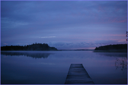
Plateliai lake is popular for its sailing, diving and fishing.
National park contains 12 natural monuments, a visitor centre and 10
museums. If you want to stay overnight you can use many of its
lodges or camp out in the forest. Keep in mind that over 10% of the
Žemaitija National Park is closed to the public in interest of
saving traditionally nesting ground for wetland birds. This includes
Rukunzhdzhsky and Plokshtinsky reserves. In the spring and summer
months it is also forbidden to visit the wetlands. Žemaitija
National Park also contains 30 archaeological sites such as mounds,
burial grounds, sacrificial hills and many more. If you get a chance
and find something keep in mind that it is illegal to remove any
ancient object from the park. The territory of the park also
contains numerous crosses, small chapels and other Christian
monuments scattered all around the park.
Former Soviet nuclear base that once housed R-12U nuclear missiles
is abandoned today. Most of interior was stripped of all electrical
wiring long time ago and many of the entrance were closed by
concrete. You can get inside and take a peek yourself at one of many
Soviet military outposts along the Western border.
Ancient Origins and Early Settlement in the Samogitia Region
The
history of what is now Žemaitija National Park is deeply intertwined
with the broader history of the Samogitia (Žemaitija) region in
northwestern Lithuania, an area known for its distinct cultural identity
and resistance to external influences. The region's roots trace back to
ancient Baltic tribes, with archaeological evidence indicating human
settlement as early as the 5th-6th centuries CE. This period saw the
formation of the original subethnic Samogitia, characterized by Central
Lithuania's flat burial grounds culture. The name "Samogitia" derives
from Latin sources, and the area was inhabited by tribes such as the
Semigallians and Curonians in its western parts, which gradually became
ethnically Lithuanian between the 13th and 16th centuries.
Early
mentions of the Baltic peoples in the region appear in Roman historian
Tacitus's Germania around 97 CE, describing the Aesti people along the
southeastern Baltic Sea shores. By the 9th-11th centuries, the area was
part of emerging Lithuanian tribal confederations, with the name
"Lituae" first recorded in the Quedlinburg Annals in 1009, noting the
martyrdom of missionary Bruno of Querfurt at the hands of pagan locals.
The region's landscape—marked by lakes, forests, wetlands, and moraine
hills—supported early settlements, including castle mounds, ritual
hills, ancient burial sites, and villages that preserved ethnocultural
traditions. Sites like the Mikytai, Šarnelė, Pučkoriai, Gegrėnai,
Jazdauskiškiai, and Grigaičiai castle mounds within the modern park
boundaries reflect this prehistoric and early medieval heritage, serving
as defensive and ceremonial centers for Baltic tribes.
Medieval
Period: Resistance, Autonomy, and Christianization
During the Middle
Ages, Samogitia emerged as a fierce stronghold of paganism and autonomy
amid the Northern Crusades. In the 13th century, under leaders like
Mindaugas (the first King of Lithuania, crowned in 1253), the region
resisted incursions by the Teutonic Knights and Livonian Order, who
sought to conquer and Christianize it under the pretext of spreading
Christianity. Samogitia, positioned between Prussia and Livonia (already
under German control), became a primary target, acting as a buffer zone
for the Grand Duchy of Lithuania. The Samogitians, known for their
warrior ethos, launched uprisings in 1401–1404 and 1409, expelling the
Teutonic Knights and securing protection from Grand Duke Vytautas.
A
pivotal moment came after the Lithuanian victory at the Battle of
Grunwald in 1410, which weakened the Teutonic Order. The Treaty of Melno
in 1422 formally returned Samogitia to Lithuanian control, establishing
it as the autonomous Duchy (or Eldership) of Samogitia within the Grand
Duchy of Lithuania. This duchy, with borders roughly aligning with
modern ethnographic Žemaitija, enjoyed significant self-governance,
including elected elders and local assemblies under the Grand Duke's
suzerainty. Samogitia was the last region in Europe to officially adopt
Christianity in 1413, retaining pagan elements in folklore and customs,
such as beliefs in woodland spirits and sacred sites. Legends, like
those of Samogitians being raised by bears or eerie sounds from Lake
Plateliai's depths, persist and add to the area's mythological allure.
The duchy's autonomy continued until the Union of Lublin in 1569, which
integrated it more fully into the Polish-Lithuanian Commonwealth, though
regional customs, the Samogitian dialect (an ancient Baltic language
with pagan roots), and leadership endured. Towns like Plateliai,
mentioned in historical sources from the 15th century, featured manors,
churches, and settlements on Lake Plateliai's shores, which became
central to the region's cultural landscape. Other cultural monuments,
such as the Žemaičių Kalvarija urban and religious ensemble, small
chapels, road shrines, and manor-park complexes like Plateliai's,
highlight the blend of Christian and pre-Christian traditions.
Modern Era: Partitions, Russian Rule, and Independence Struggles
Following the partitions of the Polish-Lithuanian Commonwealth in 1795,
Samogitia fell under Russian Empire control, where it was administered
as part of various governorates. The 19th century saw the decline of the
Latin term "Samogitia" in administrative use, but the region's distinct
identity persisted through folklore, dialect, and rural traditions. The
modern ethnographic concept of Žemaitija solidified by the late 19th
century, encompassing central and western Lithuania.
During World War
I and the interwar period, the area was part of independent Lithuania
(proclaimed in 1918). However, the Soviet occupation in 1940, followed
by Nazi German control during World War II, and re-occupation by the
USSR in 1944, marked a dark chapter. Under Soviet rule, the region was
part of the Lithuanian Soviet Socialist Republic, with borders adjusted
in puppet states like the short-lived Lithuanian State in 1947.
Soviet Era and the Cold War: The Plokštinė Missile Base
A significant
historical layer in the park's area is from the Cold War. Between 1960
and 1962, the USSR constructed the secret Plokštinė Missile Base in the
dense forests near Plateliai Lake, involving over 10,000 workers. Chosen
for its seclusion, small population, and access to lake water for
cooling, the underground complex housed R-12 Dvina (SS-4) medium-range
nuclear missiles targeted at Western Europe, including a command center,
corridors, four 100-foot-deep silos, and a power plant, all fortified
with barbed wire and electric fences. The base operated in secrecy;
locals knew of its existence but not the nuclear weapons, and U.S.
intelligence only detected it via satellite in 1978.
Decommissioned
in the late 1970s under U.S.-USSR disarmament agreements and abandoned
after Lithuania's independence in 1990, the site was looted for metal. A
nearby military town for 300 soldiers was repurposed as a children's
summer camp (Žuvėdra) from 1979 to 1990 before falling into disuse.
Tragic incidents included soldier deaths from falls and a nitric acid
spill during refueling.
Establishment of the National Park and
Post-Independence Preservation
Following Lithuania's independence
from the USSR in 1990, Žemaitija National Park was established in 1991
as one of the first post-Soviet national parks, symbolizing reclaimed
sovereignty and cultural revival. Spanning over 20,000 hectares on the
Samogitian Upland, about 45 km from the Baltic Sea, it was created to
protect the region's unique ecological, cultural, and historical
landscape. This included the largest lake-forest complex in Žemaitija,
such as Plateliai Lake (the deepest and largest, with seven islands
steeped in legend), forested swamplands like Plokštinė and Rukundžiai,
moraine landscapes, wetlands, rare flora and fauna (over 1,031 plant
species, 2,500 animal species, including endangered ones like
white-tailed eagles and lynx), and archaeological sites.
The park's
dual mandate—biodiversity conservation and cultural heritage
preservation—reflects Lithuania's post-Soviet efforts to safeguard
indigenous identity amid challenges like agriculture and climate change.
It includes 2 strict nature reserves and 27 specialized reserves
protecting landscapes, hydrography, botany, zoology, archaeology, and
ethnoculture. Key historical attractions include the restored Plokštinė
base, now the Cold War Museum (opened in 2012 with EU funding,
attracting 35,000 visitors in 2024), featuring exhibits on Soviet
propaganda, missile technology, and interactive halls. Villages like
Beržoras, Stribaičiai, and Visvainiai preserve wooden architecture and
traditions, such as Shrove Tuesday festivals.
Žemaitija National Park, also known as Samogitia National Park, is
located in western Lithuania within the Plungė District Municipality, on
the Samogitian Upland. Established in 1991, it spans approximately
21,754 hectares (217.54 km² or about 84 square miles), making it one of
Lithuania's four national parks. The park lies roughly 45–70 km inland
from the Baltic Sea, centered around the town of Plateliai, with
coordinates around 56°02′55″N 21°53′20″E. Its primary purpose is to
preserve the region's unique glacial landscapes, extensive lake and
forest complexes, and cultural heritage tied to the Žemaitija
(Samogitia) ethnographic region. The park's geography is a classic
example of post-glacial terrain, shaped by the retreat of ice sheets
around 12,000 years ago during the end of the last Ice Age, resulting in
a mosaic of hills, ridges, valleys, and water bodies.
Topography
and Landforms
The park's relief is predominantly hilly and
undulating, characteristic of the Samogitian Upland—a moraine-dominated
plateau formed by glacial deposits. Elevations range from a low of about
100 meters above sea level in the valleys to a high of 191.8 meters at
its peak, creating a varied landscape of rolling hills, ridges, and
depressions. This topography includes prominent glacial features such
as:
Moraines: These are accumulations of glacial till forming
ridges and hills. Notable examples include the Miktyvai and Pučkoriai
moraines, which contribute to the park's rugged, ridge-rich profile.
Kames: Steep-sided hills of sand and gravel deposited by meltwater. Key
sites are Šarnelė, Jazdauskiškiai, Grigaičiai, Medsėdžiai, and Liepija,
the latter being glaciolacustrine kames formed in ancient glacial lakes.
Eskers: Long, winding ridges of stratified sand and gravel from
subglacial rivers, with Gardai esker being a standout feature.
Valleys and Depressions: The Babrungas and Mergupys river valleys carve
through the landscape, while kettle holes (depressions from melting ice
blocks) dot the area, often filled with small lakes or bogs.
These elements create a dynamic terrain ideal for hiking, with trails
traversing the undulating hills and offering views of the interspersed
forests and wetlands. The overall landscape is less dramatic than
mountainous regions but provides a subtle, harmonious blend of
elevations that supports diverse ecosystems.
Hydrography: Lakes,
Rivers, and Wetlands
Water features are a defining aspect of the
park's geography, covering more than 7% of its territory and including
over 20 lakes, rivers, and extensive wetlands. The hydrography is
heavily influenced by glacial origins, with deep lake basins and
meandering streams.
Lakes: The centerpiece is Lake Plateliai, the
largest and deepest in the Žemaitija region, covering 1,205 hectares
(12.05 km²) with an average depth of 10.5 meters and a maximum depth of
47–50 meters. Its water level sits at 146.5 meters above sea level, and
it features a complex shoreline with shoals, seven islands (including
Pilies Island with ancient castle ruins), and peninsulas. Numerous
smaller lakes, such as those in hydrographical complexes like Laumalenka
and Šilinė, add to the aquatic diversity. These lakes are typically
oligotrophic (nutrient-poor and clear), supporting unique aquatic
communities.
Rivers and Streams: The longest river segment within the
park is the Uošna (13.3 km of its 16.6 km total length). The Babrungas
River originates from Lake Plateliai, flowing 47.3 km in total with 10
km through the park. Other streams contribute to a network that drains
the upland, often forming valleys with gentle slopes.
Wetlands and
Bogs: Swamps and bogs are prevalent, including scientifically
significant forested swamplands like Plokštinė and Rukundžiai. Other
notable wetlands include Paburgė, Siberija, Pakastuva, Užpelkiai,
Ertenys, Paparčiai, and the Juodupys wet grasslands. These areas, often
peat-rich, play a crucial role in water retention and biodiversity, with
some transitioning into meadows.
Forests and Vegetation
Forests dominate nearly 45% of the park (about 10,515 hectares), forming
a dense canopy that enhances the geographical mosaic. The vegetation is
primarily coniferous and mixed deciduous, adapted to the moraine soils.
Forest composition includes:
Spruce (fir) groves: 47%
Pine:
26%
Birch: 13%
Alder: 4.4%
Oak: 4.1%
Other species: Aspen,
ash, etc.
Unique forest complexes include the ancient Paplatelė,
Šeirė, and Pailgys woodlands, which are protected for their old-growth
characteristics. Forests are zoned by protection levels: 9% as strict
reserves, 31% for ecosystem preservation and recreation, 36% as
protected areas, and 24% for sustainable timber use. Meadows and
agricultural lands interspersed with the woods create a patchwork
landscape, supporting mosaic farming practices that balance human use
with conservation.
Geological and Climatic Context
Geologically, the park exemplifies Baltic Shield influences with
Quaternary glacial overlays, including till, outwash plains, and
lacustrine deposits. The climate is temperate maritime, with mild
winters (average -3°C in January) and cool summers (average 17°C in
July), influenced by proximity to the Baltic Sea. Annual precipitation
is around 800–900 mm, feeding the abundant water systems. This supports
the lush vegetation and makes the park a haven for rare flora, though
the focus here is geographical.
The hilly terrain of Žemaitija Park was formed by a
melting glacier about 12,000 years ago. The resulting hills are
relatively high, around 150-190 meters. Lakes occupy more than 7
percent. the territory of the park, the largest Lake Plateliai in
Žemaitija is located here, the sight of which cannot be separated
without the islands of Lake Plateliai. In addition to it, there are 25
smaller lakes.
Forests occupy about 45% of the park. all
territories. Particularly valuable for science are the forested wetlands
of Ploštinės and Rukundės, Plateliai lake, Laumalenko and Šilinė
hydrographic complexes, Gardės oza, Babrunga and Mergupis river valleys,
Paburgė, Siberia, Pakastuva, Užpelkiai, Erteni and Paparčiai swamps,
unique and interesting forests of Paplateli, Seire and Pailgis and
Ecosystems, rare plants and animals of Juodupis marshy meadows. Rare
salmon fish breed in Plateliai lake - seliava and Plateliai syka.
A Witch's ash grows 7.2 m in circumference, 2.1 m in diameter and 34
m in height. Next to the park, in the village of Puokės lies the largest
boulder in Lithuania - the Barstyčiai stone. Wolves live and breed, and
lynx live there all the time. 9 species of bats fly at night.
The complex archaeological complex of Northern
Žemaitija with Mikytė, Šarnelė, Pūčkiori, Gegrėnai, Ž is preserved in
the park and is very interesting for visitors. Kalvarijos and other
hillforts (11 in total) and alkahills, the old Platelia manor and Pilies
salos castle. Between Šventorkalnis and Pilies sala lake, the remains of
the ancient wooden bridge of Platelia can still be seen in the water.
The mounds are concentrated in the north-western part of the park and
often form a single complex with limestone mounds.
The well-known
town of Žemaičiai Kalvarija (Gardų) with a church and chapels of the Way
of the Cross, old traditions of the Great Calvary Indulgences. The Park
of Plateliai Manor and part of the buildings have survived in the town
of Plateliai. Noteworthy 18th century. the wooden churches of Beržor and
Plateliai, the birthplace of the poet V. Mačernis in Šarnelė, the
villages of Stirbaičiai and Visvainiai, which have preserved signs of
ethno-cultural value. A number of museums - history, ethnography, nature
and Mardi Gras expositions are open in the barn and stables of the
Plateliai manor, and the craft center will soon open. There are also
other museums: wood craftsmen in Godelii, literary museums in Bukante
manor and Žemaičių Kalvarija, art gallery in Babrungėnai. A number of
traditional Žemaitian homesteads have survived in the park - they are
located in Beržor, Godelii, Šarnelė, Žemaičių Kalvarija.
The park
has a unique exposition of militarism in the Cold War Museum established
in the former Ploštynė missile base. Tourists accompanied by park
employees can visit the underground labyrinths, explore the 27 m deep
rocket shaft. Read more about the Cold War Museum here Archived
2012-11-11 from the Wayback Machine project.
Žemaitija NP has a wide selection of various
activities. There are good conditions for fishing and walking along
educational trails. Plateliai lake is suitable for sailing, where the
Plateliai yacht club organizes the Plateliai regatta and other events
every year, and boats can be rented here. 3 routes have been prepared
for cyclists, bicycles can be rented in Platelei.
A bicycle path
leads around Lake Platelia. To the north, very close to Platelia, the
4.1 km long Šeire nature trail introduces you to unique natural values.
Lake Plateliai attracts a lot of vacationers. There are 9 campsites near
Plateliai, Luoka, Skyplaičiai, and Ilgis lakes. There is an observation
deck near Plateliai lake, beautiful panoramas open from Jazminai and
Medsėdžia mountains, Mikyty Alkakalnis, Žemaičiai Kalvarija hills. There
is a bird watching tower near Pakastuvas lake.
Every year,
thousands of people are attracted to the indulgences of Žemaičiai
Kalvarija. In the park, Halloween and St. John's Day are celebrated, a
swimming marathon is held across Lake Plateliai, and the Plateliai
regatta is held on the last weekend of July.