Location: Podlaskie Voivodeship Map
Area: 592 sq km (229 sq mi)
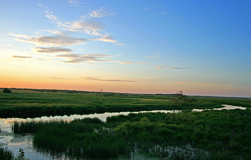
Biebrza National Park (Biebrzański Park Narodowy) is Poland's largest national park, encompassing 592.23 square kilometers in the Podlaskie Voivodeship of northeastern Poland. Established on September 9, 1993, it safeguards one of Europe's most extensive and pristine wetland ecosystems along the Biebrza River valley, often referred to as the "Amazon of Europe" due to its vast marshes, peat bogs, and floodplains. This protected area is a UNESCO-recognized Ramsar site of international importance, highlighting its role in preserving biodiversity and natural hydrological processes. The park's landscape is dominated by open moorlands, rivers, and forests, creating a mosaic of habitats that support rare species and offer a glimpse into relatively untouched wilderness.
Biebrza National Park (Biebrzański Park Narodowy) is situated in
northeastern Poland within the Podlaskie Voivodeship, encompassing the
valley of the Biebrza River. It lies near the town of Osowiec-Twierdza,
with central coordinates approximately at 53°28′00″N 22°39′41″E. As the
largest of Poland's 23 national parks, it spans a total area of 592.23
km² (228.66 square miles), divided into marshes (254.94 km²), forests
(155.47 km²), and fields/meadows (181.82 km²). The park is renowned for
its extensive wetlands, particularly the Biebrza Marshes, which
represent one of Europe's largest and least disturbed fenland systems,
supporting diverse ecosystems.
The park's geography is structured
around the Biebrza River valley, which is divided into three distinct
sub-basins: the Upper Basin, Middle Basin, and Lower Basin, each with
unique hydrological and geomorphological characteristics. This division
influences water flow, sediment deposition, and habitat formation across
the region.
Topography and Terrain Features
The topography of
Biebrza National Park is predominantly flat and low-lying,
characteristic of a broad river valley in a post-glacial landscape. The
terrain features extensive marshy lowlands, peat bogs, and fenlands,
with minimal relief variations due to its lowland setting. Dense wetland
vegetation covers much of the area, contributing to uncertainties in
precise terrain elevations during surveys. Key features include vast
expanses of untouched fenlands, which host a variety of plant
communities and provide critical habitats. The Upper Basin is notably
narrow (1.5–3 km wide) and elongated (40 km long), while the Middle and
Lower Basins broaden out, forming wider floodplains. Protected zones
like the Red Marsh (Rezerwat przyrody Czerwone Bagno) exemplify the
park's boggy, elevated peat mounds amidst the flats.
Elevation across
the park averages around 105 meters above sea level (m a.s.l.), with
subtle gradients that facilitate slow water movement and seasonal
flooding. The landscape's flatness enhances its susceptibility to
hydrological changes, such as over-drying from historical drainage
efforts in about 40% of the Upper Basin area.
Hydrology
Hydrology is central to the park's geography, dominated by the Biebrza
River, a lowland waterway that meanders through the valley and sustains
the wetlands. The river's interaction with surrounding fens involves
complex groundwater-surface water exchanges, crucial for maintaining
wetland ecosystems. In the Upper Basin, water conditions and deposit
stratigraphy have been studied through valley cross-sections, revealing
seasonal flooding patterns that shape the Lower Basin as well. The park
includes a dense hydrological network of rivers, streams, and
piezometers for monitoring, highlighting risks like soil over-drying
from past drainage works. Remote sensing tools track changes in soil
moisture, water flow routes, and peat depth, underscoring the dynamic
water regime. Overall, the Biebrza catchment's hydrogeology supports
vast marshes, with groundwater playing a significant role in ecosystem
development.
Geology and Soil Types
Geologically, the park
sits on a base of Tertiary marls ranging from 0 to -40 m a.s.l.,
overlaid by thick peat deposits formed in post-glacial conditions. In
the Upper Basin, peat layers are 3–6 meters thick, often underlain by
calcareous gyttja (a lime-rich organic sediment). The stratigraphy of
these deposits varies by basin, influenced by physiographic factors like
river meandering and flooding. Soils are predominantly peat-based,
including "reed peat" in many areas, which supports wetland vegetation
but is vulnerable to drainage and degradation. Extensive peat formations
in the marshy lowlands contribute to the park's carbon storage and
biodiversity, with ongoing monitoring to assess changes in peat depth
and structure.
Climate
While specific climate data for the
park is not extensively detailed in the sourced materials, the region's
humid continental climate features cold winters and warm summers, with
annual precipitation supporting the wetlands. Temperature and
hydrological monitoring networks in the park track these conditions,
influencing soil moisture and vegetation. The flat topography amplifies
the effects of seasonal variations, leading to spring floods and summer
dry periods that shape the geographical dynamics.
Geological Origins and Formation of the Biebrza Valley
The history
of Biebrza National Park (Biebrzański Park Narodowy) begins deep in the
Pleistocene era, shaped by glacial processes that formed the landscape
we see today. The Biebrza Valley, which the park encompasses, is a vast
depression stretching over 100 km in length. It was carved out during
the Central Polish and Baltic glaciations, approximately 10,000 to
30,000 years ago, as retreating ice sheets left behind morainic plateaus
and outwash plains. Since the end of the last Ice Age, a thick layer of
peat—reaching up to 10 meters in some areas—has accumulated over
millennia, creating one of the largest and least disturbed peatland
complexes in Central Europe, covering about 90,000 hectares. This peat
formation was fueled by the slow-moving Biebrza River, which meanders
through the valley, fostering extensive wetlands, fens, and marshes that
have remained relatively pristine due to their inaccessibility to
humans.
The valley is naturally divided into three distinct basins,
each with unique geological characteristics:
Upper (Northern)
Basin: East of Sztabin, this 40-km-long and 1.5–3 km-wide section
features peat deposits 3–6 meters thick, often underlain by calcareous
gyttia (a lime-rich sediment). Moraine outcrops dot the landscape,
remnants of glacial activity.
Middle Basin: Between Sztabin and
Osowiec, this rectangular area spans 40 km in length and 20 km in width,
with peat up to 3 meters deep overlaying sands, gravels, silts, and
clays. Extensive sandy tracts, transformed into dunes by wind erosion,
are a hallmark, though 19th-century canals have altered water flows
here.
Lower (Southern) Basin: From Osowiec to the Biebrza's
confluence with the Narew River, this 30-km-long and 12–15 km-wide basin
has peat more than 2 meters thick over sandy-gravel beds, with
occasional loam and silt. Small dunes form "islands" within the flat
floodplain, and numerous oxbow lakes line the river's muddy zones.
These geological features have created a mosaic of habitats,
including vast fenlands, riverine forests, and wet meadows, which
support exceptional biodiversity and act as natural carbon sinks and
flood regulators.
Pre-Establishment Human Activities and Impacts
Human interaction with the Biebrza Valley has been limited for centuries
due to its swampy, flood-prone terrain, which deterred large-scale
settlement and agriculture. However, sporadic activities began to
influence the area in the 19th century. During this period, the Russian
Empire, which controlled the region, constructed major engineering
projects, including the Augustowski Canal (built in the 1820s–1830s) and
smaller ones like the Woznawiejski and Rudzki canals in the first half
of the century. These were designed to connect the Vistula and Niemen
river basins for transportation but inadvertently lowered groundwater
levels, draining parts of the peatlands and altering hydrological
regimes in the middle basin. Around the same time, the Osowiec
Fortress—a massive 19th-century defensive complex—was built in the
marshes near Goniądz to guard against German incursions, utilizing the
valley's natural barriers.
In the early 20th century, during the
interwar period (1918–1939), initial conservation efforts emerged. The
Czerwone Bagno (Red Bog) and Grzędy nature reserves were established,
marking the first formal protections in the area. Elk (known as moose in
North America) received protection starting in 1925, helping preserve
populations in this refuge. The valley's isolation proved vital during
World War II (1939–1945), as it became the only region in Poland where
elk survived the conflict, avoiding widespread hunting and habitat
destruction elsewhere.
Post-war, from the 1960s onward, the gradual
abandonment of traditional haymaking and grazing—practices that had
maintained open meadows—led to ecological threats. Secondary vegetation
succession, including shrub and tree encroachment, began overtaking
wetlands, reducing biodiversity. Drainage efforts for agriculture
further degraded habitats, though the valley's core remained largely
intact compared to other European wetlands.
Establishment of the
National Park
Recognizing the urgent need to safeguard this unique
ecosystem, Biebrza National Park was officially established on September
9, 1993, by the Polish government. At 592.23 km², it became the largest
of Poland's 23 national parks, encompassing 155.47 km² of forests,
181.82 km² of fields and meadows, and 254.94 km² of marshes. The primary
motivation was to protect Europe's most extensive and best-preserved
lowland peat bogs and wetlands, which had been largely untouched due to
historical inaccessibility. The park's creation aligned with broader
European conservation trends, emphasizing the valley's role in bird
migration, hydrological balance, and carbon storage. Its headquarters
were set up in Osowiec-Twierdza, within the historic Osowiec Fortress.
Post-Establishment Developments and Key Milestones
Since its
inception, the park has focused on active management to combat threats
like habitat succession. Conservation efforts include shrub removal,
controlled mowing, and agri-environmental schemes to mimic traditional
farming and maintain open wetlands. A notable annual event is "The
Biebrza Haymaking," held in August–September, which doubles as national
championships and promotes sustainable land use.
Key milestones
include:
1995: Designated as a Wetland of International Importance
under the Ramsar Convention (reference no. 756), highlighting its global
significance for migratory birds and peatland conservation.
2010:
Awarded the "EDEN – European Destinations of Excellence" for its status
as a non-traditional tourist destination, boosting eco-tourism through
trails, kayaking, and birdwatching.
The park has also become a
hub for scientific research and education, supporting studies on climate
change impacts on wetlands and biodiversity monitoring.
Significant Events and Challenges
The park's history includes
environmental challenges, most notably fires exacerbated by drought and
human activity. In April 2020, a devastating fire—sparked by illegal
grass burning amid low water levels—raged for over a week, destroying at
least 6,000 hectares of grasslands and woodlands. It was the worst blaze
since 1992 and the first major outbreak in 17 years, though smaller
fires (15 reported since January 2020) had occurred earlier that year.
The fire threatened rare species like elk, beavers, and wetland birds,
but was contained by April 26, 2020, thanks to firefighting efforts.
Recovery has been ongoing; by 2022, two years post-fire, vegetation
regrowth was observed, though long-term ecological monitoring continues
to assess impacts.
Today, Biebrza National Park stands as a symbol of
Poland's commitment to preserving its natural heritage, often called the
"European Amazon" for its wild, untamed character. It hosts over 270
bird species, including rare ones like the aquatic warbler, and large
mammal populations such as elk (around 600 individuals) and wolves.
Ongoing challenges include climate change-induced droughts and balancing
tourism with conservation, but its protected status ensures it remains a
vital ecological stronghold in Europe.
Biebrza National Park (Biebrzański Park Narodowy), established in
1993, is Poland's largest national park, spanning approximately 592 km²
in the northeastern part of the country near the Belarus border. It
safeguards one of Europe's most pristine wetland ecosystems, centered
around the Biebrza River valley. The park encompasses a mosaic of
habitats including vast peat bogs, marshes, floodplains, wet meadows,
alder and mixed forests, fields, and sand dunes. These areas are
periodically flooded in spring, creating dynamic environments that
support exceptional biodiversity. Recognized as a Ramsar Convention site
since 1995 for its global significance as a wetland, the park is a haven
for rare and endangered species, with minimal human interference
preserving its natural state. This makes it a critical refuge for flora
and fauna adapted to wet, inaccessible terrains, often referred to as
the "European Amazon" or a "paradise for birds."
The park's
ecological value stems from its untouched peatlands—the largest in
Central Europe—which host unique plant communities and serve as
breeding, feeding, and migration stops for wildlife. Flooding plays a
key role, enriching soils and preventing large-scale drainage, which has
allowed species rare or extinct elsewhere in Europe to thrive here.
Habitats Supporting Flora and Fauna
The park's diverse habitats
are the foundation of its rich biodiversity:
Marshes and Peat Bogs:
Covering about 255 km², these are the core of the park, featuring
tussock grasses, sedges, and reed beds. They remain waterlogged
year-round, with spring floods turning meadows into shallow lakes.
Floodplains and Wet Meadows: Periodically inundated areas with
nutrient-rich soils, supporting dense vegetation and serving as feeding
grounds for herbivores and birds.
Forests: Alder swamps, mixed
birch-alder woodlands (155 km²), and riverine forests provide shelter
for mammals and birds.
Fields and Meadows: 182 km² of open
grasslands, often mowed to maintain habitats for ground-nesting birds.
Other Features: Sand dunes, river channels, and oxbow lakes add variety,
hosting specialized species like butterflies and amphibians.
These habitats create a gradient from aquatic to terrestrial zones,
fostering high species diversity and making the park a key site for
conservation.
Flora
Biebrza's plant life is adapted to wet,
nutrient-poor soils, with many species relics from post-glacial periods.
The flora includes over 1,000 vascular plant species, emphasizing
wetland communities like sedge fens, reed beds, and bog mosses. Peat
bogs host acid-loving plants, while floodplains support lush herbaceous
growth. Rare and protected species are common due to the park's
isolation.
Key plant communities and species include:
Bog and
Marsh Plants: Sundews (Drosera spp.), which are carnivorous and trap
insects on sticky leaves; clubmosses (Lycopodium spp.), ancient
spore-bearing plants; and rusty sedges (Carex spp.), forming golden
patches in autumn.
Orchids and Flowering Plants: Various orchids
(Orchidaceae family), blooming in wet meadows; Siberian iris (Iris
sibirica), with vibrant blue flowers; and marsh marigolds (Caltha
palustris), carpeting flooded areas in yellow during spring.
Trees
and Shrubs: Dwarf birch (Betula nana), a glacial relic from arctic
tundra times; common birch (Betula pendula) and alder (Alnus glutinosa)
dominating swamp forests; and willows (Salix spp.) along riverbanks.
Other Notable Flora: Grass tussock communities in swamps and alder
forests provide structural diversity.
The park's flora is under
strict protection, with areas like the Czerwone Bagno (Red Bog) Reserve
safeguarding pristine peatlands. Human activities, such as traditional
mowing, help maintain open meadows for light-dependent plants.
Fauna
The park is a wildlife haven, with:
Birds: Over 280 species
recorded, including 180 breeding ones. It's a critical site for
migratory waterfowl, with species like the aquatic warbler (Acrocephalus
paludicola)—Europe's rarest songbird—greater spotted eagle (Clanga
clanga), and great snipe (Gallinago media). Spring floods attract
thousands of geese, ducks, and waders.
Mammals: Around 50 species,
including large populations of elk (up to 800 individuals), beaver
(reintroduced and now thriving), wolf, lynx, otter, and red deer. The
elk is the park's symbol.
Biebrza offers year-round opportunities for eco-tourism, emphasizing
low-impact exploration.
Hiking and Cycling: Over 500 km of
trails, including boardwalks through bogs like the Długa Luka path.
Popular routes include the Carska Droga (Tsar's Road) for scenic drives.
Water Activities: Kayaking or canoeing on the Biebrza River (routes up
to 100 km), with rentals available in villages like Goniądz.
Wildlife
Observation: Birdwatching towers and hides; guided tours for spotting
elk or beavers, especially in spring (flood viewing) and autumn (rutting
season).
Cultural Sites: Visit Osowiec Fortress or traditional farms;
festivals like the Biebrza Bird Festival in May.
Practical Tips:
Entry is free in many areas, but permits are needed for strict reserves.
Best visited in spring for birds or summer for hiking; prepare for
mosquitoes and wet conditions. Accommodations range from campsites to
eco-lodges in nearby towns like Osowiec-Twierdza.
As a Ramsar wetland and Natura 2000 site, the park focuses on habitat restoration, combating drainage, and invasive species control. Initiatives include rewetting peatlands to mitigate climate change (bogs store vast carbon) and monitoring endangered species like the aquatic warbler through mowing management. Challenges include agricultural pressures and tourism impacts, addressed via zoning (strict protection for 25% of the area) and education programs. International collaborations, such as with the Society for Ecological Restoration, ensure long-term preservation of this vital ecosystem.