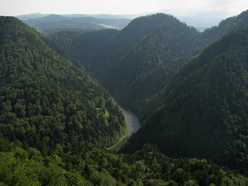
Location: Pieniny Mountains Map
The Dunajec River Gorge, also known as Przełom Dunajca in Polish, Prielom Dunajca in Slovak, and Dohnst-Schlucht in German, is a breathtaking limestone canyon carved by the Dunajec River. This natural wonder stretches through the Pieniny Mountains, serving as a natural border between southern Poland (in the Lesser Poland Voivodeship) and northern Slovakia. Spanning approximately 18 km in length, the gorge is renowned for its dramatic landscapes, featuring seven sharp meanders or loops where the river twists through vertical white limestone cliffs that rise up to 300 meters above the water. These cliffs, combined with lush vegetation, create a magical, almost untouched environment that draws hundreds of thousands of visitors annually. The gorge is part of the Pieniny National Park and exemplifies a harmonious blend of geological, ecological, and cultural elements, making it one of Europe's most picturesque river valleys.
The Dunajec River Gorge, known in Polish as Przełom Dunajca, is a
spectacular limestone canyon carved by the Dunajec River through the
Pieniny Mountains in the Western Carpathians. This natural feature forms
a significant portion of the border between southern Poland and northern
Slovakia, renowned for its dramatic cliffs, meandering river course, and
rich geological history. It is protected within the Pieniny National
Park on the Polish side and the adjacent Pieninský Národný Park in
Slovakia, highlighting its ecological and scenic value. The gorge is
often described as one of Europe's most beautiful river canyons,
attracting visitors for activities like rafting, hiking, and cycling.
Location and Extent
The Dunajec River Gorge is situated in the
Pieniny Mountains, part of the larger Carpathian Mountain system,
approximately at coordinates 49°25′N 20°31′E. It lies near the Polish
town of Szczawnica and the Slovak village of Červený Kláštor, with the
river serving as the international boundary for about 17 kilometers
along this stretch. The gorge proper spans roughly 8 to 9 kilometers in
its most rugged and scenic section, though the full border-following
reach extends longer. The Dunajec River originates in the Tatra
Mountains to the southwest, flowing northeastward before entering the
Pieniny range and incising the gorge. It eventually joins the Vistula
River after a total length of about 251 kilometers. The surrounding
region includes the Polish Lesser Poland Voivodeship and is accessible
from nearby towns like Krościenko nad Dunajcem and Sromowce Wyżne.
Geological Formation and History
The gorge exemplifies the
geological evolution of mountainous terrain from the early Cenozoic era
to the Quaternary period. It formed through a combination of tectonic
uplift, fluvial erosion, and karst processes acting on predominantly
Jurassic and Cretaceous limestone bedrock. The Pieniny Mountains
themselves are a klippe—a detached block of rock thrust over younger
strata—resulting from Alpine orogeny, the mountain-building event that
shaped the Carpathians. Over millions of years, the Dunajec River
exploited structural weaknesses, such as faults and joints, to carve
deep into the rock, creating sheer walls and meanders. Glacial activity
during the Pleistocene likely influenced the river's course, with
post-glacial erosion deepening the canyon. The petrographic composition
includes resistant limestones that form the cliffs, interspersed with
softer marls and shales that have been preferentially eroded. This
geological diversity is evident in the varied rock formations, including
pinnacles and overhangs sculpted by water and weathering.
Physical Features
The gorge is characterized by its sinuous path,
featuring seven prominent loops or meanders where the river twists
sharply through the canyon. Cliffs rise dramatically to heights of up to
300 meters along much of the length, though some sources note sections
approaching 500 meters in relief. The riverbed varies in width from
narrow chutes to broader pools, with depths fluctuating based on
seasonal flow. Key landmarks include the Trzy Korony (Three Crowns)
massif at 982 meters, the highest peak in the Pieniny, offering
panoramic views of the gorge, and Sokolica Mountain at 747 meters,
famous for its relic pine trees clinging to the cliffs. The canyon walls
display layered stratigraphy, with fossil-rich limestones revealing
ancient marine environments. Hydrologically, the Dunajec is a mountain
river with a variable discharge, influenced by snowmelt from the Tatras
and rainfall, leading to occasional floods that reshape the channel.
Dams upstream at Rożnów, Czchów, and Czorsztyn regulate flow for
hydropower, moderating extremes but altering natural sediment transport.
Surrounding Landscape and Ecosystems
The Pieniny Mountains
envelop the gorge with a mix of forested slopes, meadows, and rocky
outcrops. Vegetation includes beech-fir forests on higher elevations,
with riparian zones featuring willows and alders along the riverbanks.
The area supports diverse fauna, such as otters, beavers, and fish like
grayling in the river, while birds of prey including eagles and falcons
nest on the cliffs. Endemic species and relic flora, like the Pieniny
pine on Sokolica, underscore the region's biodiversity hotspot status.
The microclimate within the gorge is cooler and more humid than
surrounding areas, fostering unique mosses and lichens on the rock
faces.
Human Geography and Impacts
While primarily natural,
the gorge has been shaped by human activity, including traditional
rafting routes established in the 19th century that follow a
15-kilometer path from Kąty to Szczawnica. Trails for hiking and
cycling, such as the path from Červený Kláštor, parallel the river,
providing access without significant alteration. Dams have impacted
downstream ecology by reducing sediment load, potentially affecting
riverbed stability, though national park protections mitigate broader
development. The transboundary nature fosters cross-border cooperation
in conservation.
The gorge's biodiversity is exceptional, owing to its unspoiled
ecosystems and varied microhabitats. Flora here traces back to
post-glacial vegetation patterns, distinct from typical Western
Carpathian assemblages. The limestone soils support endemic and
subendemic Carpathian plants, including rare orchids, relic pine forests
on cliffs (like those on Sokolica), and diverse riparian vegetation such
as willows, alders, and ferns along the banks. In autumn, the area
bursts with color from deciduous trees like beech, oak, and maple. The
Pieniny region hosts over 1,000 vascular plant species in a compact
area, many adapted to the calcareous substrate.
Fauna is equally
rich, with the gorge serving as a refuge for Carpathian species. Mammals
include otters, beavers, deer, and wild boars, while birds abound—over
160 species, including eagles, owls, and kingfishers. Reptiles like the
green lizard and amphibians such as fire salamanders thrive in the moist
environments. Insects, particularly butterflies, are diverse, with some
endemic to the Pieniny. The river itself supports fish like trout and
grayling. Minimal anthropogenic influence has preserved these habitats,
though sightings of larger wildlife like bears are rare; more common are
ducks and smaller creatures. This high concentration of species in a
small, segmented terrain underscores the gorge's ecological value.
The Dunajec River Gorge, known in Polish as Przełom Dunajca, is a
stunning natural feature carved by the Dunajec River through the Pieniny
Mountains. Spanning approximately 8-18 kilometers (depending on the
section), it forms a natural border between southern Poland and northern
Slovakia. The gorge is renowned for its dramatic limestone cliffs rising
up to 300 meters, seven sharp meanders, and pristine ecosystems, making
it one of Europe's most picturesque river canyons. It lies within the
Pieniny National Park (established in Poland in 1932 and Slovakia in
1967) and has been on UNESCO's Tentative List of World Heritage Sites
since 2006 due to its unique geological, biological, and cultural value.
Human history in the area intertwines with its natural formation, from
ancient legends to medieval fortifications, wartime conflicts, and
modern tourism.
Geological Formation
The history of the
Dunajec River Gorge begins millions of years ago, rooted in the
geological evolution of the Carpathian Mountains. The gorge exemplifies
the main stages of mountain terrain development from the early Cenozoic
era (approximately 66 million years ago) through the Quaternary period
(the last 2.6 million years). Tectonic movements uplifted the region,
while the Dunajec River's erosive action carved through Mesozoic
limestone and dolomite strata, creating the steep cliffs and winding
loops seen today. Unlike much of the surrounding Carpathians, the
Pieniny area was not glaciated during the Pleistocene ice ages,
preserving unique botanical relics from that time, including endemic and
subendemic plant species isolated from broader Western Carpathian flora.
The gorge's formation involved interactions between geological
substrates, relief, water flow, soil, climate, and biodiversity,
resulting in high species diversity in a compact area—home to
Carpathian-endemic animals and plants. This process, driven by river
erosion and tectonic shifts, shaped a landscape of aesthetic and
scientific significance, with minimal human alteration preserving its
ecosystems.
Legends and Folklore
Local folklore enriches the
gorge's early "history," blending myth with explanations of its dramatic
formation. One prominent legend attributes the gorge's creation to King
Bolesław the Brave (ruled 992–1025 CE), who supposedly cleaved the rocks
with his sword to drain a massive mountain lake, relieving the hardships
of local inhabitants and declaring, "It will be hungry, cold, but free
here." Another tale involves a hunter named Ferkowicz, who, while
pursuing the king of snakes, tilted the gorge to allow the river to flow
through. Folk etymology links the river's name "Dunajec" (meaning
"little Danube") to ancient Slavic words for water bodies, evoking
stories of a prehistoric lake bursting through rocky barriers.
Additionally, legends tie the area to the infamous outlaw Janosik (a
Robin Hood-like figure from the 17th-18th centuries), who allegedly
leaped across the Dunajec while escaping from Niedzica Castle, leaving a
footprint in the rock. These stories, passed down through generations of
Gorals (highland folk), underscore the gorge's cultural mystique and its
role in regional identity.
Medieval and Early Modern Period
Human presence around the gorge dates back to prehistoric times, though
evidence of settlement within the gorge itself is sparse due to its
rugged terrain. By the medieval era, the area gained strategic
importance as a border zone. The Dunajec River marked shifting frontiers
between Polish and Hungarian (later Slovak) territories. Key landmarks
include the 13th-century Czorsztyn Castle (built around 1250–1280) and
the 14th-century Niedzica Castle (constructed in the 1320s), both
overlooking the river and serving as defensive strongholds against
invasions. These fortresses, now ruins or museums, were hubs for local
nobility and trade, with the gorge providing a natural barrier. The
first documented mentions of river navigation appear in the 16th
century, likely for timber transport or local travel, though not yet for
tourism. The Pieniny region, including the gorge, was a religious and
cultural center, with monasteries and villages fostering Goral
traditions.
19th Century: The Birth of Tourism
The modern
history of the gorge as a tourist destination began in the early 19th
century, coinciding with the Romantic era's fascination with wild
nature. Wooden raft trips, organized by local Pieniny Gorals, started
around 1813–1830, initially catering to aristocratic guests visiting
Niedzica and Czorsztyn castles. Józef Szalay, founder of the nearby
Szczawnica spa resort, popularized these excursions in the mid-19th
century, transforming them into a commercial attraction. Rafts, made
from tied logs and guided by skilled raftsmen in traditional attire,
navigated the 15–18 km route from Sromowce Wyżne-Kąty to Szczawnica,
offering views of the cliffs and meanders. This period marked the
gorge's shift from a utilitarian waterway to a symbol of natural beauty,
drawing artists, writers, and travelers.
20th Century: Conflicts,
Development, and Conservation
The 20th century brought both turmoil
and progress. During World War I (1914–1918), the Dunajec valley was a
frontline, with heavy fighting in 1914–1915 as German forces broke
through Russian trenches in the region. Post-war, tourism resumed,
bolstered by the establishment of Pieniny National Park in Poland in
1932. Hydropower development altered the river: dams were built at
Rożnów (1941), Czchów (1949), and Czorsztyn (1997), creating reservoirs
that flooded parts of the valley but provided energy and flood control.
In March 1975, Poland and Czechoslovakia (now Slovakia) adjusted their
border along the Dunajec to better align with natural features. The
Slovak side established its national park in 1967, fostering
cross-border cooperation. Rafting evolved, with kayaking and biking
trails added in the late 20th century.
Present Day and Legacy
Today, the Dunajec River Gorge attracts over 250,000 visitors annually,
primarily for rafting (2–3 hours, seasonal from April to October),
hiking, and cycling. It remains a geotourism hotspot, highlighting the
interplay of nature and culture in the proposed trans-border Pieniny
Geopark. Conservation efforts preserve its biodiversity, while legends
and traditions endure through Goral guides' storytelling. The gorge
symbolizes resilience, from ancient erosion to modern eco-tourism,
embodying the Carpathians' untamed spirit.
The gorge is a hub for outdoor pursuits, with traditional rafting being the highlight—a 2-3 hour gentle float (with mild rapids) accommodating up to 250,000 tourists yearly. Rafts start from Sromowce Wyżne or Červený Kláštor in Slovakia, offering narrated tours in Polish or Slovak. For the active, an unpaved 18 km cycling and walking path runs along the Slovak bank, providing intimate views amid forests and meadows—ideal for birdwatching or picnics. Hiking trails lead to viewpoints like Trzy Korony for panoramic vistas. In winter, cross-country skiing is possible, though the area is cooler than nearby regions like Krakow. Kayaking and canoeing are alternatives for thrill-seekers, while fishing requires permits. Day trips from Krakow or Zakopane are common, often combining rafting with castle visits.
Established in 1932, the Pieniny National Park (shared between Poland and Slovakia) protects the gorge's core, minimizing human impact and preserving its natural ecosystems. The park enforces strict regulations on development, ensuring low anthropogenic influence. It's on UNESCO's Tentative List for World Heritage status due to its outstanding geological, geomorphological, and biodiversity values. Conservation focuses on habitat restoration, species monitoring (especially endemics), and sustainable tourism. Challenges include flood risks and climate change effects on vegetation, but collaborative Polish-Slovak efforts maintain its pristine state. Visitors are encouraged to follow "leave no trace" principles to sustain this unique monument of nature.