Hotels, motels and where to sleep
Restaurant, taverns and where to eat
The old Castilian city of Ávila is the capital of
the province of the same name and the episcopal see. It has been a
UNESCO World Heritage Site since 1985 due to its city
fortifications, which are well worth seeing.
With its
numerous medieval buildings, Ávila is one of the most attractive
cities in Spain. The city has about 50,000 inhabitants and is 1130 m
above sea level, near the Sierra de Gredos. Saint Teresa of Ávila
was born here. A large number of sacred buildings are dedicated to
her both inside and outside the city walls. In Ávila settled around
700 BC. the Celtiberian Vettones. The Romans emerged in the 3rd
century B.C. BC, built the first city walls and made Ávila a
fortress. After the victory of the Moors over the Visigoths, Ávila
lost importance. In the 11th century the city was rebuilt and
repopulated. It is said that Raimundo de Borgoña, son-in-law of King
Alfonso VI, oversaw the rebuilding of the city walls over the ruins
of the old Roman fortress. Ávila experienced its heyday in the 16th
century through wool production. With the money earned, numerous
secular and sacred buildings were erected, which can still be
admired in the old town today. The landmark of Ávila is the city
wall. The Puerta de los Leales (Gate of the Faithful), one of the
main gates of the old city, leads to the 12th-14th century
Cathedral. It resembles a fortress. The 16C tower of the Torreón de
los Guzmanes is now the seat of the Provincial Council. Ávila has
numerous noble houses built between the 16th and 18th centuries.
Actually the city is called Ávila de los Caballeros (the Ávila of
the noblemen).
Cathedral of the Savior of Avila. Its construction is between the
twelfth and fifteenth centuries. It enjoyed a military and defensive
function thanks to its fortified head, whose cimorro is mounted on the
city wall itself. Initially it was built in the Romanesque style, by
Master Fruchel. At the beginning of the 13th century, a Gothic style was
adopted in the works. The master Fruchel began the works inspired by
the Saint-Denis basilica During the first third of the 14th century,
Bishop Sancho Blázquez Dávila reactivated the works of the cathedral.
It is one of the buildings that began the penetration of the French
Gothic on the peninsula and is considered the first Gothic cathedral in
Spain. It is built mainly of granite. The cathedral has a Latin cross
plan, with three naves, transept and ambulatory. The main chapel, with
two sections and an apse, is covered by a ribbed vault and has two
levels of windows. with the participation of Juan de Borgoña. The
cloister is connected to the transept through a portal from the 14th and
15th centuries, in the southern part of the cathedral. The retrochoir of
the cathedral is carved in limestone and represents seven Scenes from
the life of Jesus. It was made by Juan Rodríguez and Lucas Giraldo, both
students of Vasco de la Zarza, in the period between 1531 and 1536-1544.
Basilica of San Vicente. Its construction began in the 12th century in
the Romanesque style and ended in the 14th century, with the finishing
of the north tower. The final phase of this has been attributed to the
French master Giral Fruchel, introducer of the Gothic style in Spain and
who participated also in the construction of the cathedral. The general
structure is similar to the Latin basilicas. It has a Latin cross plan,
three naves, a dome, tribunes, three apses, an atrium, two towers and a
crypt. The interior has a Latin cross floor plan with three naves with
six sections.
St. Peter's Church. Romanesque church located outside
the walled enclosure, in the Plaza del Mercado Grande, opposite the gate
of the Alcázar. The beginning of its construction is dated around 1100
and its end around the year 1130. It would undergo various reforms
throughout the 13th and 14th centuries. It presents analogies with that
of the Basilica of San Vicente, built around the same dates. It is built
of sandstone, with a granite plinth. It has a basilica plan with three
naves. The façade is pyramid-shaped and has a large rose window in its
central part.
Hermitage of San Segundo. Hermitage located to the west
of Ávila, outside the walled enclosure, on the right bank of the Adaja
river. It preserves Romanesque vestiges although it was reformed during
the 16th century. Alabaster statue made by Juan de Juni. The popular
belief tells that by introducing a handkerchief into the tomb and asking
for three wishes, the saint grants one of them.San Segundo is the patron
saint of Ávila and his pilgrimage is celebrated on May 2.
Royal
Monastery of Santo Tomás. Dominican convent built at the end of the 15th
century. The church has a Latin cross plan with five sections crowned by
a star vault. The main altarpiece contains paintings by Pedro
Berruguete, which illustrate episodes from the life of Santo Tomás. It
was the summer residence of the Catholic Monarchs.
Convent of San
Jose. It is a convent of Discalced Carmelite nuns. It was the first
foundation carried out by Santa Teresa de Jesús and the starting point
of the Teresian reform. It was built in 1562, although the church, its
most interesting architectural element, began to be erected in 1607.
This was designed by the architect Francisco de Mora (1553-1610), who
conceived a temple with a single nave, covered with vaulted ceiling and
dome in the transept. It has been a National Monument since 1968.
Currently the building serves as the headquarters for the Teresian
Museum of the Discalced Carmelites.
Church-convent of Santa Teresa.
Built at the beginning of the 17th century.
Parish Church of
Santiago. Located to the south of the city, it is of Romanesque origin,
only retaining some traces of this style on the walls. It was rebuilt
with berroqueña stone at the beginning of the 16th century, in the late
Gothic style. According to tradition, they were armed the knights of the
Order of Santiago from the city. It consists of a single nave with four
sections and chapels between its buttresses. Its 14th-century octagonal
tower stands out, although it was rebuilt in 1803 due to a collapse in
the upper part. superior.
Convent of the Incarnation. It arose as a
beguinage in a different location and then, in 1513, moved to the
current location —at that time a Jewish cemetery— to become a monastery
for religious with vows. Santa Teresa entered it in 1533 and prepared
its reform for 27 years. In the 17th century it underwent reforms in the
vault and the cupola.
Sanctuary of Our Lady of Sonsoles. The
Sanctuary of Sonsoles is located about 5 km southeast of the city of
Ávila. The exact etymology of the sanctuary's name is not known, but it
is suspected that the name Sonsoles may come from Fons Solis —"the
fountain of the sun"—, which would refer to the water spring that exists
in the place. The temple had to be rebuilt in 1480 due to its
dilapidated state. Inside the sanctuary is a carving of the Virgin of
Sonsoles, co-patron saint of Ávila and patron saint of the province's
fields. It is a tradition in the city during the month of May to make a
pilgrimage on foot to the sanctuary.
Church of San Andres. Romanesque
church from the 12th century located to the northeast of the city. It
has a basilica plan with three naves, with their corresponding apses,
the central one being the largest. It underwent a restoration in the
year 1930.
Church of Saint Nicholas. Romanesque church from the 12th
century, located to the south of the city. It has three naves, with
three access doors, and a semicircular apse. It also has a quadrangular
tower. It was reformed in the 17th century.
Church of Saint John the
Baptist. Temple of Romanesque origin built during the 12th century. It
underwent a severe reform in the 16th century, in the late Gothic style.
It consists of a nave with three sections with chapels on both sides.
According to an inscription in this church, Santa Teresa was baptized in
the year 1515.
Hermitage of San Martin. Romanesque church located in
the northern part of the city, it was rebuilt in 1705. Its quadrangular
tower stands out, the oldest part of the building, from the 14th
century. The tower has a base of berroqueña stone on which is the upper
body, built in brick and in the Mudejar style.
Hermitage of Santa
María de la Cabeza. Small hermitage with Mudejar elements located in the
north of the city.
Church of Mosen Rubí. 16th century church that
blends the late Gothic and Renaissance styles.
Royal Monastery of
Santa Ana. Building whose construction began in the year 1250 (although
only a staircase and a paving remain from this period). It was declared
a site of cultural interest on January 15, 1982.
Convent of Santa
Maria de Gracia. Convent belonging to the Order of San Agustín, it was
founded at the beginning of the 16th century. Saint Teresa received
classes at the convent school.
Magdalena Convent. Former Hospital de
la Magdalena, it is currently a convent of Franciscan Conceptionist
nuns. It housed the city's comedy corral.
Humilladero de Los Cuatro
Postes. Monument of the 16th century located on the outskirts of Ávila.
It is made up of four Doric columns, in the center of which, on a
pedestal, stands a granite cross. Today it serves as a viewpoint, from
where you have magnificent views of Ávila.
Former convent of Santa
María de Jesús. Better known as Las Gordillas, it was founded in 1552
for the Clarisas nuns. His church still has worship. It was declared a
National Monument in 1991.
Hermitage of Humilladero. Hermitage with a
square floor plan, built outside the walls during the second half of the
16th century, a few meters from the Basilica and the San Vicente gate,
to the east of the old town. It was the headquarters of the Illustrious
Board of Santa Vera Cruz.
The city of Ávila has a large number of palaces,
mansions and fortified houses, most of which date from the 15th-18th
centuries, and which are distributed mainly in the upper area of the
walled enclosure, and the neighborhoods between the Church of San Pedro
and San Vicente, as well as its surroundings. In addition to those
detailed in the list below, the episcopal palace or palace of the Child
King, the Episcopio, the Lesquinas palace, the Guillamas House, the
Rengifos palace, the Don Gaspar Bullón palace (demolished) stand out. ,
the palace of the Marqués de Fuente el Sol, the Casa de las Carnicerías,
the Casa del Cordón and the Casa or Hospital del Caballo.
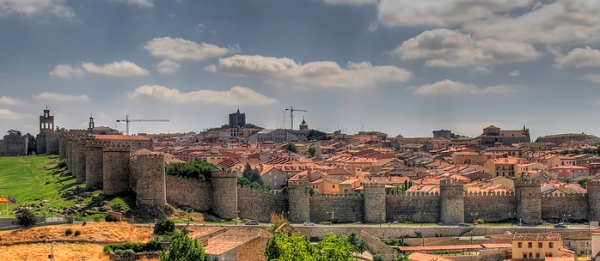
Walls of
Avila. It is the main monument of the city and its hallmark, it was
built between the 11th and 14th centuries. It is the best preserved
intact wall in Spain. The medieval work began in the year 1090. The
fenced space is 31 ha, it has an approximate perimeter of 2516 m; 88
cubes or semicircular towers, 2,500 battlements, 3 m thick canvases, an
average height of 12 m and nine doors. It is the largest fully
illuminated monument in the world.
Ávila Town Hall. Located in the
Mercado Chico square, it was built during the second half of the 19th
century and was the work of the architect Ildefonso Vázquez de Zúñiga.
The façade is built of granite and has Elizabethan reminiscences.
Palace of the Eagles. Palace of the 16th century, it was renovated at
the beginning of the 20th century, with a restoration of a romantic
nature. It is located inside the wall after going through the gate of
San Vicente.293 He defended this access from Muslim troops. It is
located on a street occupied by different branches of the Águila family.
Mansion of the Velada. Palace of the 16th century, also known as Torre
de los Aboín, stands out for its large masonry tower, with granite
ashlars. After being restored in 1993, it currently functions as a
hotel.
Valderrabanos Palace. Palace from the 15th century, of which
its Gothic portal and the body of the tower are preserved, rebuilt in
the 19th century. It is currently a hotel.
Palace of the Dávila. Also
known as Palacio de los Abrantes, it belonged to the House of Dávila.
Its oldest part corresponds to the 13th century. It consists of several
buildings and is characterized by an architecture with Moorish details.
Palace of Núñez Vela. Palace of the 16th century that rises in the Plaza
de La Santa. It belonged to the first viceroy of Peru, Blasco Núñez Vela
and was ordered to be built in 1581. It has had various uses, including
a barracks, infantry and cavalry military academy, headquarters of the
Royal Textile Factory and finally a building of the Provincial Court.
The Vela family was closely related to the Saint, since Francisco Núñez
Vela was godfather at the baptism of Saint Teresa, and his brothers
would leave for the Indies with this family.
Palace of the
Executioner. Palace built in the first quarter of the 16th century, it
is located on López Núñez street. It has a quadrangular floor plan with
an interior patio inside the building. On the main façade it has two
towers, next to which there is a stone boar.
Bracamonte Palace. Also
known as the Palace of Santa Cruz, its construction began at the
beginning of the 16th century. It is located in the Plaza de Fuente el
Sol. The building has a square plan and presents late Gothic and
Renaissance elements. The palace stands out for its large porticoed
patio, with two levels of galleries.
Palace of the Superunda. Palace
dating from the second half of the 16th century, it was initially
ordered to be built by the councilor Ochoa de Aguirre, but it later
became the property of the family of the Counts of Superunda. It has two
towers with three levels each and has an interior patio. In 1920 the
Italian painter Guido Capriotti adopted it as a rental residence, until
it was acquired by the painter himself in 1954, after which he proceeded
to subject the building to various reforms.It currently houses a museum.
Polentinos Palace. Palace built in the 16th century, it is located on
Calle de Vallespín. Its construction was ordered by the councilor Juan
de Contreras and later it became the property of the Counts of
Polentinos. In the 19th century it was acquired by the City Council.
Torreon de los Guzmanes. It was built during the first third of the 16th
century. It is a large tower with a square plan crowned with triangular
battlements, former palace of the Garcibáñez de Muxica family. It was
the residence of King Alfonso XII during the year 1878. It is currently
the headquarters of the Diputación de Ávila.
Palace of Juan de Henao.
16th century palace. It is currently a Parador de Turismo.
Deans
Palace. Stately mansion from the 16th century with a Plateresque façade,
it is located in the Plaza de Nalvillos. It consists of two buildings
and an interior patio. Currently in it is the Provincial Museum of
Ávila.
Serrano Palace. Palace of the 16th century located between
Estrada street and the Plaza de Italia. It currently houses a cultural
center-library managed by Caja de Ávila.
Avila slaughterhouse. Built
between 1888 and 1890 in the vicinity of the Monastery of La
Encarnación. It is a neo-Mudéjar style building consisting of a room
with a protruding attached central body for housing on the ground floor
and a fur storage room on the first floor.
Lienzo Norte congress and
exhibition center. Construction began in 2007, and its execution was
completed in April 2009. The building was officially inaugurated by the
King and Queen of Spain, Juan Carlos and Sofía, on January 13, 2010. It
is designed by the architect Francisco Mangado. He has been awarded the
Chicago Athenaeum Architecture Award.
The main museum in the city is the Museo de Ávila,
inaugurated in 1911. In 1968 it acquired the identity of a Provincial
Museum. It has been managed by the Junta de Castilla y León since 1987.
The museum has two locations: the Casa de los Deanes, a 16th-century
Renaissance palace that functions as the main headquarters, and the
church of Santo Tomé, originally built in the 12th century, which is
used as a visitable warehouse. The collections are included in three
large sections: one representative of the rural culture of the province,
another that includes pieces found in Avila territory from Prehistory to
the 19th century and finally one dedicated exclusively to archaeological
pieces found in urban excavations in the city of Avila.
Inside
the Cathedral of Ávila, the Cathedral Museum is installed, which houses
an exhibition of religious art. In the convent of La Encarnación there
is also a permanent exhibition, which shows various historical
testimonies of Santa Teresa de Jesús as well as various pieces of
religious art. It also preserves pieces related to the life and work of
San Juan de la Cruz. In the crypt of the convent of Santa Teresa is
located the museum of Santa Teresa, which exhibits the work and life of
the saint, as well as various pieces of religious art.
Inside the
monastery of Santo Tomás there are several museums, such as the Oriental
Art and the Natural Sciences. The Oriental Art Museum was inaugurated in
1964, it is located in the third cloister of the Santo Tomás Monastery
and houses a varied collection of pieces from Japan, Vietnam, the
Philippines and China. The Natural Sciences Museum houses a collection
of zoological specimens that were part of the old cabinet of natural
history of the Dominican order of the monastery.
The city also
has the Caprotti Museum, located in the Superunda Palace, which houses
the work of the Italian painter Guido Caprotti, who has lived in Ávila
since 1916.
There are also various exhibition halls, such as the Water room, the Torreón de los Guzmanes room, the Diputación room and the Episcopio room. Man", with the best of Castilian-Leon sacred art. This exhibition lasted 223 days and received a total of 859,859 visitors. During 2006, the exhibition "Las dos orillas" was held, commemorating the V centenary of the death of Christopher Columbus. During the summer you can access night visits to the wall, which are guided and dramatized on weekends. In these, part of the history of the construction of the walls and the city is told.
The city has four public libraries: the Ávila public library —in the Plaza de la Catedral—, the José Jiménez Lozano library —in Avenida de la Inmaculada—, the Posada de la Feria library —Plaza de la Feria— and the Olegario González de Cardedal library —on Don Jesús Jiménez street—
The commercial cinemas in the city are the "Estrella" movie theaters, in the "Comercial el Bulevar" center, with six rooms. For a time there was a cinema known as "Tomás Luis de Victoria" located on Lesquinas street. .
The patron saint festivals of Ávila are those of Santa
Teresa de Jesús, on October 15, and San Segundo, on May 2. The city's
summer festivals take place during the second half of July. The Virgin
of Sonsoles is also the patron saint of Ávila.
Holy Week in Ávila
has been considered to be of Regional Tourist Interest since 1993 and of
National Tourist Interest since 2005. From 2014 to the present it is
considered to be of International Tourist Interest.
Medieval market: During the weekend after the first
Friday of September each year, a medieval market takes place in the
historic center of the city. You can enjoy an atmosphere, shows and
gastronomy typical of the Middle Ages. The motto under which it is
celebrated "The market of the three cultures" refers to the main
cultures that have been involved in the history of the city: Christian,
Jewish and Muslim. During this week part of the city and many of its
inhabitants dress in period dress and parades and shows are held during
the day and night, in different thematic areas that have their
respective names: Jewish Quarter, Arab Souk, Military Camp/Archers,
Christian Merchants, Medieval Camp, Corner children, Episcope or
Falconry.
Festival of Street Theater and Circus Arts. It takes place
in the summer season and different street shows are held, free of
charge.
Artavila. It is an annual craft contest. It takes place
during the month of August on Paseo del Rastro and is organized by the
Ávila Various Crafts Association (ADAVA).
E Mouth. Sample of wine and
local products, is promoted by the Association of Sommeliers of Ávila
(ASA), and in 2013 it took place during the month of February.
Old
Book Fair and Occasion. Annual fair competition, is organized by the
Association of Old and Antique Books of Castilla y León (ALVACAL). It
takes place in the Plaza de Italia or in the Paseo del Rastro.
The Ávila bullring, second category, is located in the south of the city, next to the Adolfo Suárez stadium, and has a capacity of 8,491 spectators. Since 2013 it has been managed by the company "Por Naturales S. L." , which replaced “Servicios Taurinos del Duero, S.L.” in this role. In the summer of 2013 figures such as Julián López El Juli or Miguel Ángel Perera fought in the square.
Characteristic on Avila's tables are the boat's bean
dishes, the Ávila T-bone steak, the revolconas potatoes and the Santa
Teresa egg yolks. Also typical of the city are hornazo, a bread roll
stuffed with chorizo, bacon, loin and egg, veal sweetbreads or suckling
pig (called roasted tostón), cuchifrito in the capital and baked in
Arévalo.
Avila buds. This typical sweet of the city is made in
the traditional pastry shop "La Flor de Castilla" under the name "Yemas
de Santa Teresa". The rest of the city's pastry shops also make it but
under the generic name of "Yemas de Ávila" or simply "Yemas". They are
made as their own name indicates from the egg yolk.
T-bone steak from
Avila. It is a large ribeye grilled and rare. It can be enjoyed at any
hotel point in the city. The T-bone steak is made from Avilanian veal, a
native breed of black specimens and excellent meat. Ávila meat has a
protected geographical indication.
Two of the key figures in the history of Ávila are the
16th century mystics Santa Teresa de Jesús and San Juan de la Cruz, who
spent a good part of their lives in the city and where they wrote part
of their literary work.
The Irish writer Kate O'Brien wrote
numerous works in which she addressed the theme of the city of Avila. In
Adiós, España (1937) he dedicated a chapter to the city and in his novel
Mary Lavalle (1936) there are also references to the snowy landscape of
Ávila in winter. O'Brien would continue with allusions to the city in
his work Esa Dama (1946) to finally write Teresa de Ávila, a biography
of Santa Teresa de Jesús in 1951. Ávila was a summer resort for the
writer until the Spanish Civil War broke out. The writer would later
return to the city, to reside for half a year, between 1961 and 1962, at
the Hotel Jardín.
The Spanish Noucentista writer Alberto Insúa,
born in Cuba, would write about the city, choosing it as the setting for
his novel En tierra de santos (1907).
What is that one!... But,
joking aside, it is necessary to change your life, Don Alfredo. Starting
tomorrow you will come with me to walk around Ávila. I will show you the
beautiful Ambles valley, with its blue mountains, which look like a
miniature of those in Switzerland. We will go around the walled
enclosure and you will see the relics of Santa Teresa: a finger, a staff
and the sole of a sandal, which you will devoutly kiss. I will introduce
you, if you wish, to the three daughters of Mr. Batalla, who would like
to be the soles of sandals, and I will force you to become intimate with
the father of the three virgins, so that you, he, and I can discuss like
three theologians."
Alberto Insúa, In the land of saints, 1907, p.
66.
Enrique Larreta, an Argentine author attached to Modernism,
included Ávila in passages of his work La gloria de don Ramiro.
When they were left alone, the young man, muted by the tumultuous
impressions that played with his spirit, got up nervously and, going
over to the window, opened the shutters. Ávila, covered in snow, shone
under the magical light of the moon like a city of enchantment».
Enrique Larreta, The glory of don Ramiro, 1911, chapter XXIII.
Miguel de Unamuno would dedicate a chapter to Ávila —titled Facing
Ávila— in his work Andanzas y visiones españolas (1902). The writer from
Valladolid Miguel Delibes would also inspire the city in part of his
work, setting his first novel, La sombra del cypress is elongated, in
post-war Ávila.
Ávila, thanks to its wall and its appearance as a medieval city, has been the setting for the filming of scenes from a large number of films. These include Holy Queen (1947), The Black Knight (1954), Pride and Passion (1957), 128 Gulliver's Travels (The Three Worlds of Gulliver, 1960), Teresa of Jesus (1961), Golfus of Rome (1966), The Phynx (1970), The Stars Are Green (1973), The Lords of Steel (1985), Outside the Walls (1985), The Merry Rogues (1988), The Shadow of cypress is elongated (1990), The kingdom of heaven (2005), Shevernatze, an epic in reverse (2007), Teresa, the body of Christ (2007) or Adolfo Suárez, the president (2010).
The city of Ávila has the publication of Diario de
Ávila, a Spanish newspaper with a provincial scope whose origin dates
back to 1898. There are also different online publications of news from
the city and the province, such as Tribuna Ávila, Ávila Digital —closed
in February 2012—, Ávilared and Gente en Ávila.
During the 19th
century there were other newspapers, now disappeared, such as El
Porvenir Avilés, El Eco de la Verdad or El Eco del Comercio. However,
most of the 19th-century press had a very limited diffusion, being
economically unfeasible projects.
Ávila has different stations
that provide news about the city and the province, such as Cadena Ser
Ávila or COPE Ávila, as well as state or regional stations such as Radio
Nacional de España, ABC Punto Radio, Vive! Radio, Kiss FM or Cadena
Dial.
News from the city and province of Ávila is covered by a
regional television channel, Radio Televisión de Castilla y León, which
has two DTT channels, Castilla y León TV or "La 7 de CYLTV" and its
sister channel La 8 of CYLTV.
In the old town, to the west of the cathedral, is the
Plaza Mayor.
Around the Plaza de los Dávila there are many medieval
noble houses in the Renaissance style. The palaces Mansión de los
Velada, Valderrábano and Núñez-Vela are worth seeing. However, the most
beautiful is Palacio Dávila. It consists of four houses built from the
13th century. The battlements and a Renaissance window are interesting.
At the Plaza de Santa Teresa stands the monastery of Theresa (see above)
The Plaza del Mercado Chico (Small Market Square) is located in the
center of the city. The Ayuntamiento (City Hall) and the Iglesia de San
Juan (Church of San Juan) stand on it.
Dolmen of the Prado de las Cruces. Funerary monument
dating from the late Neolithic, located near the hamlet of
Bernuy-Salinero.
Site of the Plaza del Mercado Grande. In 2001,
various archaeological remains of both Roman origin —different types of
ceramics— and late medieval and even pre-Roman origins were found in the
Plaza de Santa Teresa.
Old tanneries in the suburb of San Segundo.
Archaeological site located on the outskirts of the city of Ávila, on
the right bank of the Adaja River, which constitutes a singular and
relevant example of an artisanal complex dedicated to the tanning of
skins in operation from the 14th to the 18th centuries. They were
declared as an asset of cultural interest in 2010. Wooden vats, ceramic
and masonry pieces, sewers and remains of basins used in tanning have
been found at the site.
By plane
Adolfo Suárez Madrid-Barajas Airport at 125 Kms.
Valladolid Airport 130 Kms.
Salamanca-Matacán Airport at 90 Kms.
By train
Through the station of Ávila of Renfe , the city is connected to
various capitals and provinces, being especially good connection to
Madrid. Most of the trains that travel from north to south of Spain
pass through the city, and from the city there is a railway line
connecting Madrid and Salamanca.
It is expected that with the start-up of the
Madrid-Segovia-Valladolid high-speed line, the frequency and
centrality of the Ávila station will decrease in favor of the
aforementioned line.
In bus
On March 18, 2014, the new bus station of Ávila (Av. De Madrid, 2)
was inaugurated , located a short distance from the railway station.
By car
The main access roads to the city are:
N-403 From Toledo to Valladolid
N-110 From Plasencia to Segovia
AP-51 A Villacastín and Madrid
N-501 To Salamanca
N-502 To Talavera de la Reina
CL-501 To El Escorial and Madrid
AV-804 To Villanueva de Gómez y Arévalo
Splurge
Parador de Ávila, Calle Marques de Canales y Chozas 2 (From Av de
Madrid follow C Ronda Vieja then Plaza Concepcion Arenal), ☎ +34 920
21 13 40. 4-star parador in 16th C palace within the city walls.
Free guest parking.
Roast lamb
Asado de Cabrito
Yolks Santa Teresa
Beans from El Barco
Cochinillo de La Moraña
Wines of Rueda and Cebreros
Meson El Rastro
The Cancels
The Extremeño
Olimpo Restaurant
At night Vallespin St. is the best choice for young travellers. During the day you can take tapas with beer (caña) in the square "el grande" behind the cathedral.
There are various theories regarding the origin of the name of the
city. On the one hand, there are historians who, believing the word to
be of Punic origin, assign to it the meaning of "high and grown
mountain", while other researchers grant it a Hebrew origin, giving rise
to the idea of "limit or border". Based on Basque, derived -according to
Basque-Iberianism- from the language spoken by the ancient Iberian
peoples, it could refer to "breña, matorral, monte bajo". On the other
hand, the philologist Joan Coromines proposed a Germanic origin derived
from the Gothic Awilô or Awila.
There has been some dispute as to
whether the Vetonian city of Obila, described by Ptolemy in his
Geographia, corresponds to Ávila; however, this relationship is not
clear. The city was officially called Ávila de los Caballeros until the
1877 census, the year in which it lost this designation and became
simply Ávila. The name used to refer to its inhabitants is abulense
—both masculine and feminine— and, less commonly, also avilés.
The coat of arms of Ávila is made up of a gules or red field on which
King Alfonso VII appears represented in the apse of the Ávila cathedral
together with the motto: «Ávila del Rey, de Los Leales, y de Los
Caballeros». The blazon of the shield consists of the following heraldic
description:
Coat of arms framed on cartouche. On a field of gules,
the top of the Cathedral, masoned in its color, through which a child
king appears who wields a sword in his right hand and a globe in the
left.
Avila City Hall
The flag used by the city consists of its coat of arms on a purple background. During the Spanish War of Independence, the Ávila volunteer regiment used another flag as its insignia, which consisted of a white cloth with the cross of San Andrés, the city's shields, two lions with a crown and the legend "For Fernando VII. Avila Volunteers.
The first title, "Ávila del Rey", was granted to him by Alfonso VII because it was the city where he lived during his childhood and which protected him from the interests of his stepfather, Alfonso I the Battler, King of Aragon. "Ávila de los Leales" was granted by Alfonso VIII, in similar circumstances. It was due to the support of the city for the young king, where he remained a refugee from the age of five to eleven, fleeing from the persecution of his uncle Fernando II de León, first to San Esteban de Gormaz, then to Atienza and, finally to the aforementioned city of Ávila. The last title, "Ávila de los Caballeros", was granted by the monarch Alfonso XI, who took refuge in Ávila when he was only one year old, this time in the cathedral of the city.
Within the municipality of Ávila, near the town of Bernuy-Salinero, a
funerary monument dating from the end of the Neolithic to the beginning
of the Bronze Age known as the Prado de las Cruces dolmen is preserved.
The name of the city could have Veton origin. The 19th-century
Hellenist Karl Wilhelm Ludwig Müller studied the hypothesis that the
Vetonian city of Obila, described by Ptolemy in his Geographia,
corresponded to present-day Ávila; according to Roldán Hervás this
relationship is doubtful. The specific date of its foundation is
unclear. , but some investigations would date the origin of Obila in the
second half of the 1st century BC. According to some historians, Obila
was one of the many Veto settlements in the province, along with the
castros of Sanchorreja, Berrueco, Mesa de Miranda, Las Cogotas, El Raso
and Ulaca. The settlement of Obila would gain importance with the
growing Romanization of the territory, to the detriment of other forts
located in mountainous terrain. The Vetones left traces of their
settlement throughout the geography of the province of Ávila,
highlighting the stone statues known generically as boars .
Some historians point out that the current city of Ávila was an
ex-novo foundation by the Romans, who would give it the name of Abila,
Obila, Abyla or Abela. The Roman city was made up of the current old
town, the area surrounded today day by the walls. The ancient Roman
presence in the city is manifested through the Roman bridge, the road
and different mosaics, which are some of the remains of this era that
have survived to the present day. The Roman necropolis was located to
the east, beyond San Segundo street, so that in all that part of the
wall you can see funerary pieces reused as construction materials:
stelae, altars, milestones, "verraquitos" and stelae and granite
cinerary capsules, embedded in the canvases of the eastern wall.
The greatest splendor of the city under Roman rule took place in the 1st
and 2nd centuries AD. In the economy of the city, transhumant livestock
always enjoyed special importance, in relation to the routes that
crossed the Sierra de Gredos through the port of Pico and Tornavacas. In
the time of Emperor Constantine, the city of Ávila formed part of the
Roman province of Lusitania. The city experienced a certain decline from
the 3rd century, in the context of a general crisis in Roman Hispania as
a result of the Franco-Alemania invasions and a certain process of
abandonment of the cities, in favor of the villae, such as the nearby
examples of El Vergel in San Pedro del Arroyo and Pared de los Moros in
Niharra. An epidemic of plague, started around AD 250-252, decimated the
population of the city for twenty years.
The first Visigothic settlements in the peninsula were made gradually
and in small groups throughout the 5th century and the beginning of the
6th century. After the Visigoths initially occupied Gaul —the Visigothic
kingdom of Tolosa— they would later spread throughout the peninsular
territory to end up forming the Visigothic kingdom of Toledo in the
sixth century, which would last until the Muslim invasion.
The
Visigoths used the land to grow cereals and feed their cattle. The main
testimonies of this Visigothic domination in Ávila come from inscribed
slates found in different parts of the province, among which those of
the town of Diego Álvaro stand out. The importance of Ávila in this
period was due to its religious character, since Abela's prelates
intervened in the Toledo councils. Ávila was the episcopal seat during
the Visigothic domination. In the year 610, the capital and its bishop
were given preeminence over all the other provincial churches, in a
decree issued during the reign of Gundemaro.b Another trace of the
Visigothic period in Ávila is the temple of Santa María la Antigua. The
chronicles record that this monastery was founded before the year 687,
and would have been a mixed monastery —monks and nuns— until the arrival
of the Arabs.
There is not much information about Ávila under Muslim rule, whose
Arabic name was Ābila (آبلة). In the year 714 the city was dismantled by
Tárik or by Muza, therefore it must be assumed that at that time it was
walled. The only thing that seems certain is that the city became a
strategic point, always desired by Arabs and Christians. as a defensive
enclave, and that the confrontations for its possession were permanent.
There were incursions of several Christian kings in the city after the
Muslim occupation, but they did not settle. Alfonso I carried out
several expeditions in Muslim territory, firstly in Galicia in the year
742 and later a campaign through the center of the peninsula, in which
cities such as Salamanca, León, Zamora, Segovia or the city of Ávila
itself fell. The raids of Alfonso I had the Sierra de Guadarrama as
their southern limit. These military campaigns did not have the
objective of occupying the cities, but rather the intention of
destroying the defenses, collecting loot and, taking advantage of the
fact that the Christian settlers of the city followed the king in his
withdrawal, to obtain settlers for the occupied lands and warriors for
the defense of the Christian kingdoms.
After these incursions,
three centuries followed in Ávila of which few events are known. From
the eighth century, many cities on the plateau and the peninsular center
can be considered within the so-called "strategic desert", where there
was a strong depopulation and which became a no man's land, being the
scene of the raids of both forces. In 785, the city seems to have been
under Muslim rule again, since it was visited by Abderramán I. According
to the chronicles, the city was taken by Alfonso III —in campaigns that
reached the Tagus— and his domain was secured after the battle of
Simancas, under the reign of Ramiro II de León. The city fell back into
Muslim hands during Almanzor's campaigns at the end of the 10th century.
The codex of the blessed of the cathedral of Gerona from the year 975
cites the occupation and attempts to repopulate the city by Count
Fernando Flaínez, son of Flaín Éctaz, adding that —although it was
considered a Toledo city— they did not inhabit it at that time Muslim
citizens. After some timid attempts at repopulation by the Count of
Castilla García Fernández, in 1007 Abdelmelic Almudafar demolished its
walls to the ground. During the reign of Fernando I de León the city was
practically destroyed.
At the end of the 11th century, Alfonso VI of León commissioned his
son-in-law Raimundo de Borgoña to repopulate the center of the
peninsula. In order to protect Toledo, he proceeded to repopulate and
surround the cities of Salamanca, Ávila and Segovia.
This moment
also constituted the starting point of a council or alfoz of enormous
size around the city of Ávila, which surpassed the mountains of the
Central System on its southern border. Citizens of Navarrese, Franco,
Aragonese, Aragonese, Mozarabic, Basque, Cantabrian and Asturian. Among
these settlers the lineage of the Dávila arose, starting with Ximén
Blasco —governor of Ávila and who died in 1108— who came to the city
together with his brother Fortún Blasco —future governor of Ocaña and
who died in 1107— from Salas of Asturias,87 and whose lineage
participated in the liberation of Cuenca, under the command of the Avila
crossbowmen, and of Ocaña. Alfonso VI—, as the year in which the
reconstruction works of Ávila, its walls and the Temple of the Savior
began. other authors that date the construction of it is well into the
12th century. group of villages, populated by vigorous horsemen and
abundant cattle.
During this time, feudal relations were
established between peasant and lord through the establishment of
agrarian contracts. A relatively important textile industry stands out,
which, however, could not compete with Flemish and Italian cloth.
Central—such as Seville or Córdoba under the command of caudillos such
as Muño Alfonso (mayor of Toledo) or Sancho Jiménez "el Giboso". By the
year 1142 the possession of the city was in charge of Rodrigo Fernández
de Castro el Calvo. In 1162, as a reaction to an uprising in Salamanca,
the militias of Ávila —whose tenure at that time was governed by
Manrique Pérez de Lara— supported the people of Salamanca and faced the
royal army of Fernando II de León in the town of Valmuza in a
confrontation from which the Leonese monarch emerged victorious.
Subsequently, Manrique having reconciled with the monarch, the former
died and his brother Nuño Pérez de Lara took the heir to the Castilian
throne —Alfonso VIII— to Ávila, where he stayed for three years .
With the passage of time, the process of the Reconquista moved
progressively towards the south and Ávila remained in the background.
Despite this loss of importance, Ávila was one of the seventeen cities
of the Crown of Castile that continued to send attorneys to the Cortes
during the 14th and 15th centuries, after the reduction of those
throughout the 15th century. During the First Castilian Civil War it is
known that in 1367 the city was attacked by the English, because of
Ávila's support for Enrique II of Castile, and that some houses in the
suburbs of the city burned down.103 During the Second Castilian Civil
War (1465-1468) between the supporters of Enrique IV and his half
brother, the infante Alfonso, on June 5, 1465, the event of the Farce of
Ávila took place in Ávila, in which King Enrique IV was deposed in a
ceremony in which Prince Alfonso was crowned.
Ávila was one of
the seventeen cities of the Crown of Castile —together with Burgos,
Córdoba, Cuenca, Guadalajara, Jaén, León, Madrid, Murcia, Salamanca,
Segovia, Seville, Soria, Toledo, Toro, Valladolid and Zamora— with the
privilege —it was considered as such despite the expenses it entailed—
of the right to vote in Cortes after the reduction in the number of
these by the Catholic Monarchs in 1480. This group of cities, with the
exception of Toro, ended up configuring current provinces.
During the reign of the Catholic Monarchs, in the second half of the
15th century, and of Carlos I and his son Felipe II, already in the 16th
century, the city was reborn again thanks to the comings and goings of
the court. Ávila prospered and the province witnessed the birth of
various religious figures, writers and spiritual advisers such as Teresa
de Cepeda y Ahumada —better known as Santa Teresa de Jesús—, born in the
capital, and San Juan de la Cruz, who was born in the town of
Fontiveros. His council was one of the main organizers of the War of the
Communities and the first Santa Junta was formed in it.
From the
end of the 16th century and the beginning of the 17th century, the city
began a long decline and depopulation. The beginning of this decline was
inscribed in the phase of difficulties that the Spanish Empire was going
through, which dragged Castile with it. In 1599 an epidemic of plague
carried off almost 12% of the city's population. part of the expulsion
of the Moors issued in 1609 by the monarch Felipe III affected 13.8% of
the inhabitants of Ávila. Other factors that influenced the decline of
the city were the plummeting decline in textile activity and the large
number of beggars, supported by the large number of charitable
institutions existing in the city. In 1618 the city had only 1,500
inhabitants, an amount that would increase to the 4,085 corresponding to
the year 1752.
Ávila is in extreme decline, and to a large extent
this must be attributed to the fact that, out of as many estates as it
had, hardly a resident owner has remained [...] Everything is full of
landlords and administrators, determined to raise the rent to the
maximum. [...] The Court has absorbed countless families from a century
to this part, who played a great role [...] because they had flourishing
estates that they later abandoned to the management of proxies.
Antonio Ponz, 1778 (Madoz, 1984, p. 3)
At the end of the 18th
century, the foundation of the Royal Cotton Factory took place in Ávila,
installed in 1788 with state capital by the English technicians John
Berry and Thomas Bilne. However, the project was a failure, since its
cotton fabrics did not they found an outlet in the market and, after a
notorious lack of productivity, it would be transferred in 1799 to
finally end up establishing a wool factory there.
The city of Ávila was sacked by the French on January 4, 5, 6 and 7,
1809, by order of the French Marshal Lefèvbre. French troops looted
several churches in the city, as well as private houses, and the city's
slaughterhouse was set on fire. At the beginning of the 19th century,
the roads that communicated the city with the surrounding area were of
very poor quality, although at In the mid-century, those connecting
Ávila with Madrid —via El Espinar— and the port of Pico would be
substantially improved.
Throughout the 19th century, the city
continued with the decadence and stagnation characteristic of previous
centuries. Pascual Madoz described it in 1845 as a "ruined and gloomy"
city. In 1864 the poet Gustavo Adolfo Bécquer said of it:
Almost
lost in the twilight mist and enclosed within its jagged walls, the
ancient city, homeland of Santa Teresa, Ávila, the one with the dark,
narrow and crooked streets, the one with the dust-covered balconies, the
corners with altarpieces and the eaves. outgoing There is the
population, today as in the sixteenth century, silent and stagnant.
Gustavo Adolfo Bécquer, 1864 (Sanchidrián Gallego, 2007, p. 16)
During the First Republic, Ávila was one of the cities in which the
cantonal movement spread, the revolutionary manifesto would be signed on
July 20, 1873. During the second half of the 19th century there was a
slow demographic recovery with the construction of the railway, which
made the city an important junction on the line from Madrid to the
French border through Irún. In 1936, after the outbreak of the Civil
War, the city, like practically all of Castilla y León, quickly became
part of the area occupied by the rebel troops. In the city of Ávila it
existed in 1936 a Francoist concentration camp, as well as a Condor
Legion air base.
Main article: Spanish Civil War in the province
of Ávila
During the Franco dictatorship, the process of depopulation
of the province intensified, which necessarily affected the city. In
1956, the Fadisa factory was installed in the city, dedicated to the
manufacture of vans under the Alfa Romeo license.
On March 18,
1977, Ávila incorporated into its municipal area the extinct
municipalities of Aldea del Rey Niño, Alamedilla del Berrocal, Narrillos
de San Leonardo and Vicolozano; and on January 25, 1977 to Urraca-Miguel
and Bernuy-Salinero. In 1996 the Catholic University of Ávila was
founded in the city. In December 2004 there was an attack by the
terrorist group ETA in the city, when the a small 1 kg ammonal bomb in
the toilets of a cafeteria in Avila on Calle Reyes Católicos, which
caused material damage in said establishment and in another nearby
business.
Ávila's participation in Spanish society has been quite
limited throughout the 20th century. Despite this, the city has served
as a launching pad for the careers of various national politicians.
Already in the 19th century, Mariano José de Larra obtained a seat in
the Cortes when he presented himself for Ávila. In the same way, the
former presidents of the Government of Spain Adolfo Suárez —who was
elected in 1967 as attorney in Cortes in Ávila— and José María Aznar
—who was elected deputy in the Cortes for Ávila in 1982—, as well as
former ministers Agustín Rodríguez Sahagún, Agustín Díaz de Mera and
Ángel Acebes, also began their political career in the city.
Ávila is geographically located in the Northern Plateau of the
Iberian Peninsula. It is located at an altitude of 1,131 m, on a rocky
promontory on the right bank of the Adaja river —a tributary of the
Duero— and it is the highest province capital in Spain. Its municipal
area covers 231.9 km², on 3 % of the surface of the province.
The
city is the capital of the province of Ávila and of the Ávila region
—which includes the Amblés valley and the Sierra de Ávila—, as well as
the seat of judicial district number 3 of the province and of the
diocese of the same name.
The municipality of Ávila —with a very
irregular perimeter— limits to the north with those of Cardeñosa,
Mingorría, San Esteban de los Patos, Tolbaños, Berrocalejo de Aragona,
Mediana de Voltoya and Ojos-Albos, to the east with that of Santa María
del Cubillo, to the southeast with those of Navalperal de Pinares and
Herradón de Pinares, to the south with Tornadizos de Ávila, to the
southwest with Gemuño, to the west with those of El Fresno, La Colilla,
Martiherrero and Marlín and to the northwest with the de Bularros and
Monsalupe.a The territory of the municipal area is represented on sheets
506, 531 and 532 of the National Topographic Map.
The land within
the municipality is destined for five fundamental uses: wooded areas,
fields destined for cereal cultivation, pastures, riverbanks, wastelands
and urbanized areas. The wooded surface of the municipality is located
to the north of this, the cereal crops along the Amblés valley and to
the south of the city, while the pastures are located mainly in the
eastern zone.
The situation of the municipality, in the transition between the Central System and the North Plateau, causes that there are great altimetric contrasts in it. The point with the highest altitude in the municipality, at 1,536 m above sea level, is in the Sierra de Malagón, to the west of the territory, while the point with the lowest altitude, at 969 m above sea level, is located on the from the Adaja river when leaving the municipal area. The city is surrounded by different mountain formations: to the south is the Sierra de la Paramera, to the east the Sierra de Ojos Albos and the Sierra de Malagón and to the west the Sierra de Ávila. the municipal term there is a total of four geodesic vertices installed.
Geologically, the municipality of Ávila is represented by two very different blocks. On the one hand, there is one made up of materials corresponding to the Hercynian Massif, formed by igneous rocks from the Upper Carboniferous-Lower Permian —mostly granitic— and by metamorphic rocks dating from the Lower Precambrian-Cambrian, in which the former are intruded. On the other hand, there is a block formed by sedimentary materials from the Mesozoic, Tertiary and Quaternary, which are located in the eastern part of the Amblés valley, next to the Adaja river.
The municipality is crossed by the course of the Adaja river, belonging to the Duero hydrographic basin —with its source in the municipality of Villatoro— and which borders the city on its west side. The Adaja river runs through the Amblés valley in a west-east direction and the extension of its basin is about 770 km². The Chico River, a tributary of the Adaja formerly known as the Grajal stream, also flows through the city to the south. The two sources of water supply for the city are the Serones and Becerril reservoirs. The Serones reservoir is a straight-plan dam, built in 1984 and with a capacity of 5,800,000 m³. The Becerril reservoir is a masonry dam built in 1930, with a subsequent remodeling in 1971 with mass concrete. It has a capacity of 1,800,000 m³. In cases of extreme drought, the city uses water from the Fuentes Claras reservoir, with a capacity of 920,000 m³. In the north of the municipality there are also two small wetlands, the lagoons of Terreros and Taeña.
According to the Köppen climate classification criteria, Ávila's
climate can be described as Csb (Mediterranean oceanic) type. Other
sources describe Ávila's climate as continental Mediterranean with some
mountainous nuance. The city's climate It is highly conditioned by its
altitude, which exceeds 1100 m above sea level, being the highest
province capital in Spain. Thus, Ávila is one of the coldest provincial
capitals in Spain, with an average annual temperature of around 11 °C.
The daily thermal amplitude is high (around 12 °C) due to the great
distance to the sea and the altitude. The annual thermal amplitude is
also high, standing between 17 and 18 °C. Thus, Ávila has a mild summer
and a cold winter, going from an average of between 20 and 21 °C in July
to an average of around 3 °C in January. The minimum averages are
between -2 and -1 °C in January, thus producing frost on most winter
nights. Snowfalls are also frequent in winter due to the altitude of the
municipality, with an average of about 20 days of snow per year. In
summer, temperatures rise considerably during the day, reaching a
maximum average of between 28 and 29 °C in July; however, the nights are
cool, with an average minimum of between 12 and 13 °C in this month
Annual rainfall, which is around 400 mm or slightly above, is low
compared to the surrounding areas. The scarcity of rainfall, together
with the irregular and slow flow of the Adaja River, with strong drought
in the summer months, has meant that the city has historically had water
supply problems. This scarcity of rainfall is highly conditioned by the
geographical location of the city immediately to the north of the
Central System. The minimum rainfall occurs in summer (as is typical of
Mediterranean climates), particularly in the months of July and August,
although there is also another minimum —less marked— in the months of
February and March. The rainiest months are May, October and November.
The average annual humidity is around 63%, with a large oscillation
between the cold months, which are much more humid, and the warm ones,
which are very dry.
Below is a table with the climatological
values in the reference period between 1983 and 2010 at the AEMET
observatory located in the Hervencias district (Ávila) at 1130 m s. no.
m. Note that the extreme values are also taken in the period 1983-2010.
The absolute maximum temperature record is 37.6 °C, recorded on July 24,
1995, and the minimum is -16 °C , recorded on January 15, 1985. The
maximum precipitation in one day is 88.8 mm recorded on November 5,
1997, and the maximum gust of wind is 107 km/h recorded on February 25,
1989. All the records registered in the current observatory of the
Hervencias district.
The municipality of Ávila overlaps with four areas of the Natura 2000
Network, three of them with the category of ZEPA —Special Protection
Area for Birds— and all of them proposed as SCI —Site of Community
Importance—.
Holm oaks of the Sierra de Ávila. Natural space
designated as ZEPA that has a surface area of 9495.94 ha, all within the
province of Ávila. It affects a small area in the northwest of the
municipality of Ávila, near the town of Alamedilla del Berrocal. The
predominant plant formations are holm oak, with Quercus ilex and Quercus
rotundifolia, and gorse heaths. The most important bird species are the
imperial eagle, which had a pair in 2002, and the golden eagle, with a
pair in 2000.
Holm oaks of the Adaja and Voltoya rivers. This natural
space designated as ZEPA, has an area of 27,047.93 ha. Most of the
natural space is found in the province of Ávila, with a small fraction
in that of Segovia. It encompasses a large part of the northern sector
of the municipality of Ávila. The predominant type of vegetation is also
holm oak, in which areas of low-sized holm oak predominate, along with
meadows of Quercus spp. The Adaja and Voltoya rivers cross the natural
space . Among the birds, the black stork —Ciconia nigra— stands out,
with one pair, and the imperial eagle, with two or three pairs in 2005,
in addition to the blue kite or the eagle owl.
Azálvaro field-Pine
groves of Peguerinos. This natural space designated as ZEPA, with an
extension of 28,373.80 ha, extends through the provinces of Ávila and
Segovia. It occupies an important area of the northeastern sector of the
municipality of Ávila. Within it is included the Serones reservoir,
which dams the waters of the Voltoya river. Regarding the vegetation,
the mountain broom predominates with isolated groves of tree-like
species . In 2005 there were two pairs of black storks and two other
imperial eagles, as well as populations of marsh harriers, golden
eagles, peregrine falcons and lesser kestrels.
Banks of the Adaja
River sub-basin. This natural area extends over 1,232.58 ha in the
provinces of Ávila, Segovia and Valladolid. In the province of Ávila it
partially affects the courses of the Adaja and Ullaque rivers. In the
municipality of Ávila it encompasses the course of the Adaja and a 25 m
strip of land on each bank of the river. This area is made up of the
stretch of river that runs from its entrance in the municipality of
Ávila, next to the municipality of El Fresno, to the Puente del Adaja,
belonging to the urban area of the city.
Ávila is one of the least populated provincial capitals in the
country. It is the most populous municipality in the province, as well
as the largest, concentrating around 34% of the total population of the
province. The population of the urban nucleus is 56,144 inhabitants. The
population density is 243.36 inhabitants/km².
The foreign
population registered in 2012 totaled 5,339 inhabitants (9.05% of the
total), with the most numerous nationalities being Romanian (1,708
inhabitants), Moroccan (772), Colombian (594), Dominican (278), Peruvian
(231) and the Ecuadorian (224).
The data of the 2012 population
pyramid can be summarized as follows:
The population under 20 years
of age is 19.8% of the total.
The one between 20-40 years is 27.96%.
The one between 40-60 years is 29.12%.
The older than 60 years is
21.84%.
The municipality has an area of 230.70 km2. In 2022 it
had a population of 57,730 inhabitants and a density of 250.23
inhab/km2.
it would be Pedro García Burguillo, who had previously been mayor of
the Segovian town of Villacastín between 1969 and the support of nine
councilors, compared to 7 for the PSOE and 5 for the CDS. The mayor was
José Luis Pujades Martín, who, however, would resign for personal
reasons. The municipal government during this term was plagued with
difficulties, such as the Plan of Urban Planning, a problematic water
supply, the delay in the construction of a new slaughterhouse or the
strong municipal debt. In this situation, Pujades Martín's successor in
the mayor's office, Isidoro Heras Díaz, from Unión Liberal, also
submitted his resignation, saying goodbye with the phrase: "I want peace
and that's why I'm leaving." The third mayor within this term It was
Mario Galán Sáez, whose election only had the votes of the Popular group
in favor, because the PSOE and CDS councilors decided not to participate
in it.
In the 1987 elections, the centrist CDS would win, with 11
councillors, compared to 6 from Alianza Popular, 3 from PSOE and the
only one from Izquierda Unida. The mayor of the city during this stage
was Antonio Encinar Núñez. In the 1991 elections, the Popular Party
prevailed, with 11 councilors, compared to 5 from the centrist CDS, 4
from the PSOE and the councilor obtained by Izquierda Unida. The mayor
during this period would be the future Minister of Public
Administration, Justice, Interior and spokesman for the Popular party
Ángel Acebes Paniagua. In the 1995 elections, the Popular Party rose to
power again, with 14 councilors, against the 3 from the PSOE, 3 from the
IU and the one obtained by the Agrupación Independiente de Ávila. The
mayoress during this legislative period, in which there was an intense
activity of works and improvements to the public spaces of the city, was
Dolores Ruiz Ayúcar, who after finishing her term tried to continue and
seek re-election, but the Popular Party appointed Agustín Díaz de Mera
as the future candidate for the 1999 elections.
After the 1999
elections, the mayoralty was again occupied by a member of the Popular
Party, in this case the previously mentioned Agustín Díaz de Mera, with
13 councilors compared to 5 from the PSOE and 3 from the IU. Díaz de
Mera, however, would leave his position in 2002 because he was appointed
general director of the Police and could not reconcile both positions.
He would be replaced by Miguel Ángel García Nieto, who would manage to
win the mayoralty in three consecutive elections —2003, 2007 and 2011—.
In the 2011 municipal elections Miguel Ángel García Nieto, of the
Popular Party, revalidated his position as mayor when his political
party prevailed in the elections against the PSOE, UPyD and IU groups,
headed respectively by Juan Antonio Chamorro, Manuel Vicente and Montse
Barcenilla .
The City Council is divided into the following
management areas:
Presidency, Interior and Culture
Urbanism,
Heritage and Environment
Social Services and Treasury
Employment,
Industry, Commerce and Tourism
Employment, Industry, Economic
Development and Innovation, Trade and Consumption
Culture, Education
and Annexed Neighborhoods
Services to the City
Social Services,
Citizen Participation, Equal Opportunities and Youth
Sports and
Parties
Local Management
The city is the capital of the province of the same name. 159 The Provincial Council of Ávila is headquartered in Ávila. It is the institution that corresponds to the government and administration of the province of Ávila. Since 1987 the location of the Provincial Council is the Torreón de los Guzmanes.128
Ávila is the head of the judicial party number 3 of the province of Ávila, to which 106 other municipalities of the province belong. This assignment was established by the Law on Demarcation and Judicial Plant on December 28, 1988.
In 2007, 78.3% of the municipality's workers were located in the service sector, 11.4% in construction, 8.7% in the industrial sector and only 1.5% in the primary sector. To date In 2011, the unemployment figure in the municipality was around 13.5% (5,543). The municipal budget in 2010 was €64,199,099. In 2011 there were a total of 18 banks, 38 savings banks, savings and 5 credit unions in Ávila.
The primary sector represents a small percentage of the labor market
in the municipality, 1.5% of the workers. Most of the rustic land not
intended for pasture and non-cultivated areas is used for dry land
(2,170 ha) and slow-growing timber species (4,648 ha). According to the
INE in 2009, the municipality's cattle herd was 6973 livestock units.
The municipal term is included within the area of beef with
protected geographical indication Carne de Ávila, of the Avilanian-black
Iberian breed.
One of the economic engines of the city of Ávila is the industrial
sector. The city has two industrial estates, Las Hervencias and
Vicolozano.
Vicolozano industrial estate: located to the
northeast of the city, 2.5 km from it. It is located between the N-110
and AP-51 highways. Inaugurated in 2002, it is divided into two sectors,
Vicolozano I and Vicolozano II, with a total area of 615,162 m², 436,578
m² of which are industrial land.
Polígono de las Hervencias:
located within the town of Ávila, on the road to Valladolid. It is
located next to the "Cordel de las Moruchas" business park and the
Logistics Center of Castilla y León. It has a total of 141,420 m², of
which 80,064 m are industrial land.
There is an important factory
of the Nissan company. This was founded on July 26, 1956 under the name
of Sociedad Anónima de Fabricación de Automóviles Désel (Fadisa), but
the factory would not be inaugurated until April 21, 1959. In the first
instance it was dedicated to the manufacture of Alfa Romeo vans. . In
1967 it would be absorbed by Motor Ibérica and after several changes of
hands it would end up becoming the property of Nissan Motor Ibérica S.A.
in 1987. In 2013 it had a staff of 503 workers and it carried out the
production of three models of truck.
The service sector is the real engine of the Avila economy. Tourism
is one of the cornerstones of Ávila's economy. The city is a benchmark
within the tourist offer of Castilla y León, with great historical,
cultural and landscape value. tradition of “excursion city”.
Approximately 70-80% of tourism in Ávila is of Spanish origin and the
average length of stay in the city does not usually reach two nights,
therefore "proximity tourism" predominates. Tourism in the city
experienced a boom during the year 2004, as a result of the exhibition
of Las Edades del Hombre, after which it stabilized its growth, to, from
2008, begin to feel the inevitable effects of the crisis.
It is
one of the cities with the greatest influx of tourists in search of
rural tourism during Holy Week in Spanish territory. Ávila has
experienced a very positive evolution of its hotel beds, since in 1976
it only had 688, 1192 in 1995 and in 2009 it already had 2,684. There
are many guided offers by the city council —which generate huge
benefits— of the city, as well as a tourist train, called "Murallito".
Ávila has a municipal market —Mercado Municipal de Abastos— located
on Tomás Luis de Victoria street. Every non-holiday Friday of the year,
a market with vegetables, fruits, nuts, pickles or various crafts takes
place in the Mercado Chico square. In the vicinity of the bullring, the
sale of clothing, footwear, leather goods, crafts, antiques, hardware,
numismatics, philately or mineralogy also takes place on Fridays. On the
outskirts of the city, to the northeast, there is a shopping center
called Bulevar with different fashion, home and accessories stores.
In the city there are five public Secondary Education centers, the
IES Alonso de Madrigal, IES Isabel de Castilla, IES Jorge Santayana, IES
José Luis López Aranguren and IES Vasco de la Zarza. private, where
secondary education is also taught, the Asunción de Nuestra Señora,
Pablo VI, Purísima Concepción «Las Nieves», Santísimo Rosario Mosén
Rubí, Diocesan Minor Seminary and the Miraculous Medal.
Ávila has
the Ávila Campus, a university institution specializing in teacher
training, health sciences and engineering. The Campus is made up of
three centers: the Ávila Higher Polytechnic School, the Ávila University
School of Education and Tourism and the Ávila University School of
Nursing. The first two centers are part of the University of Salamanca
and the third is attached to it. The Catholic University of Ávila (UCAV)
also has its headquarters in Ávila. It is a private university founded
in 1996, which offers 12 degrees and 10 official master's degrees.
The city has a headquarters of the Official School of Languages
where English, German, French and Italian courses are taught. It also
has the Tomás Luis de Victoria Professional Music Conservatory, where
elementary and professional education is given — since 1999— and which
depends on the Ministry of Education of the Junta de Castilla y León.
There is also an Adult Education Center.
In 1986 the University
of Mysticism was founded in the city, officially called the
Teresiano-Sanjuanista International Center. It is a teaching institution
dedicated to promoting the systematic study of the spiritual doctrine of
Saint Teresa of Jesus and Saint John of the Cross. It is not a
university in the strict sense of the term.
The city currently has two hospitals. The Nuestra Señora de Sonsoles hospital is located northeast of the urban center and has a total of 381 installed beds, 8 operating rooms and 2 delivery rooms. The Provincial Hospital of Ávila, smaller in size, is located to the south of the city and has 88 beds and 3 operating rooms. Apart from these two hospitals, there are currently five primary care centers: Ávila Norte, Ávila Sur Este , Ávila Sur Oeste, Ávila Estación and Ávila Rural.
Ávila has the provincial office of the Spanish Red Cross, which in
2013 had 3,470 members and 2,151 volunteers. There is also the
headquarters of "Cáritas Diocesana de Ávila", on San Juan de la Cruz
street. Basic municipal social services , of a generic nature and aimed
at all sectors of the population of Avila, are offered through a network
of four centers: “Centro de Acción Social Zona Centro”, “Centro de
Acción Social Zona Norte”, “Centro de Acción Social Zona South” and
“Centro de Acción Social Zona Este”.
There is also a social
emergency aid plan, a school cafeteria scholarship program for Preschool
or Primary students with low economic resources, a shelter center for
transients managed by Cáritas —with 30 places—, a plan for municipal
rental housing; as well as orientation and counselling, family
orientation and community animation programs.
Ávila has been the headquarters of the National Police School since
1980, where the courses and training programs for access to the Basic
and Executive Scales of the National Police Force are taught, as well as
other training programs focused on students from other police forces and
courses. intended for promotion within the Corps. The city police
station, on San Roque street, is the only one in the province where DNIs
are issued.
The city has a mobile fire station —located since
1996 in the Hervencias industrial estate, since the city fire brigade
was founded in 1863— as well as a Civil Protection corps.
In the municipality there are a total of nine service stations for
fuel supply, three of them from the Repsol company, as well as Cepsa or
BP facilities.
Between the municipalities of Ávila and Tornadizos
de Ávila there is a wind farm called Parque Eólico de los Altos de
Voltoya, installed in 2004. It has a nominal power of 11.88 MW, thanks
to 18 Gamesa G47/660 turbines of 660 kW each, with a diameter of 41 m.
In 2006, Endesa was awarded the contract to install another wind farm in
the Urraca-Miguel district, with a total of 19 850 kW unit power wind
turbines.
Ávila has a waste treatment plant in the Urraca-Miguel
district, which has been operating since 2004 and provides service to
the entire northern part of the province, collecting garbage from
different transfer plants, as well as from the city. It is managed by
the private company Urbaser, from the ACS group. The plant has
biomethanization and composting units for the line of organic waste. The
biogas generated in the first of the processes is used for self-supply
of the center, in addition to discharging energy to the network, while
the sludge generated is destined for the composting tunnels, where an
aerobic process is carried out.
In the city there is a
wastewater treatment plant on Calle del Batán, managed by the Ávila City
Council and with a treatment capacity of 100,000 equivalent-inhabitant.
In 2009, this treatment plant generated a total of 8,590 tons of
non-hazardous waste, coming from the screening, sand removal, sludge and
mixtures of oils and grease processes generated in the treatment of
effluvium from Ávila.
The interior of the city still maintains today the typical layout of Roman winter-type cities —stable castros—, rectangular in outline, with two main streets —cardo and decumano— that intersect orthogonally in the center, where the forum was. Currently this layout appears only partially modified, easily recognizable old Roman entrances at the gates of San Vicente and Gonzalo Dávila, where the original defensive cubes were included in the medieval wall. The quadrilong blocks are also maintained as a reminder of the Roman insulae. The maximum thistle corresponds to the current street of Vallespín; while the maximum decumano would be made up of Calle de los Caballeros and Calle de Bracamonte. All of them come together in the Plaza del Mercado Chico, which was the old forum. Roman. An ancient hermitage would also supposedly date from Roman times, on which the Basilica of San Vicente was later built.
Regarding the exact date of construction of the wall, the symbol of the city, there is some debate. The oldest historiography (16th century) affirmed that it was built between 1090 and 1099 —practically immediately after the Christian reconquest of the city— on walls with a Roman, Visigothic and Muslim past, attributing a mythical origin to it, since it was supposedly built in its origins. by Alcideo, son of Hercules. Other more modern authors propose an initial reconstruction at the end of the 11th century of the old Roman walls, for protection against a possible Muslim attack, to begin the construction of the current wall in the middle of the 12th century. The city's cathedral began to be built in the second half of the 12th century, with the intervention of the French architect Giral Fruchel in the project. At the end of the Middle Ages, the wall of Ávila had a moat and, necessarily, a drawbridges. However, these elements disappeared with the entry into the 16th century.
At the beginning of the 16th century, in the old part of the city,
within the wall, two very different areas appeared: the northern area,
between the cathedral and the Mercado Chico, and the southern area. In
the first one were the palaces and homes of the hidalgos and clerics,
while in the southern area were the homes of the Jews and Muslims. The
Moors were installed to the north, outside the wall, as well as to the
south, populating the suburbs of Santiago and San Nicolás. Of the
different types of cities that were formed in the Spain of the
Habsburgs, Ávila was assigned the label of "conventual city".
During the Spanish Golden Age (1550-1650) the city underwent intense
urban renewal, in which a multitude of convents and palaces were built.
Starting in the 17th century, the city began to suffer a demographic
crisis, which crystallized in the progressive abandonment of the western
half of the walled enclosure, while a firmer urban structure was
consolidated in the eastern half of the enclosure and the Mercado Grande
was established. as the nerve center of the city. The first projects for
the city's water supply date back to 1509, the year in which a channel
was designed to carry water from Las Hervencias to a fountain in the
Plaza del Mercado Chico, however This project did not take definitive
form until the year 1635.
During this Renaissance stage, the old
town hall of the city was also erected, by the master stonemason Pedro
de Viniegra, between 1510 and 1517, however the works would not be
finalized until 1591. The Alhóndiga (1593), the Butchers (1590), the
Slaughterhouse (1563) and the Flour Weight. In 1676 the city of Ávila
had a total of eight hospitals. During the reign of Felipe IV
(1621-1665) the University of Santo Tomás de Ávila was built, which
remained active until 1807, the year in which the movement of the
Enlightenment put an end to the institution. In 1704, on the occasion of
the War of the Spanish Succession, the city authorities carried out
various restoration operations on the wall, with the aim of dealing with
a hypothetical Anglo-Portuguese attack.
Also in the 18th century,
the Parque del Rastro was created, a tree-lined promenade located in the
southern part of the city, next to the wall, as well as the construction
of the Royal Cotton Factory, a work that ended in 1788 and which It was
initially carried out by two architects from Avila, Ceferino de la Serna
and Juan de Mendina, to be finished off by José de la Vallina.
The Plaza del Mercado Chico was originally designed by the famous
architect Ventura Rodríguez in the 18th century, although it would not
finally be built until the mid-19th century by Juan Antonio Cuervo, a
process in which the construction of the new town hall was also carried
out. by Ildefonso Vázquez de Zúñiga.
Throughout the 19th century
there was speculation about the possibility of demolishing the wall —not
carried out, naturally— in a context in which many other Spanish cities
carried out this same action, arguing it on the basis that these walls
made it difficult for development and growth of urban centers, assuming
demolition a symbol of modernity. The survival of the wall would be
assured, however, with its declaration in 1884 as a National Monument.
In the middle of the 19th century, the city began to expand to the
east, around the newly opened railway line. This would give rise to a
small extension, which included the Recreo and San Antonio gardens. The
San Antonio garden is located in the northeast of the city, between
Paseo de don Carmelo and Avenida de Santa Cruz de Tenerife . At its
eastern end it is bounded by the railway. The park emerged as a public
promenade and boulevard during the 16th century, coinciding with the
founding of the convent of San Antonio. The park was configured as it is
known today in the year 1859. e In 1872 the avenue was replaced, as a
result of a disease that attacked these trees, by the existing gardens
today. Another hallmark of the park is the La Sierpe fountain, located
on the central promenade. The Recreo Garden is a small park located next
to the Santa Ana convent. On this triangular space that was used during
the 18th century as a Escuela Militar, the municipal architect Ildefonso
Vázquez de Zúñiga wrote in 1861 a pre-project for beautification that
materialized in the park that currently exists. 1934 al Recreo—music
concerts take place during the summer period.
Throughout the 20th
century, the city managed to maintain, despite the great demographic
growth, its historical-architectural ensemble, in a process that doubled
the total surface area of urban land. During this century, the San Roque
parks were created and Saint Vincent. The San Roque promenade consists
of a wooded space located to the east of the walled enclosure. Although
there was previously a wooded area, the small park that exists today was
established in 1946. The San Vicente park is located next to the San
Vicente gate of the same name. This landscaped space was configured as
it is today in 1961, after the actions of the City Council to beautify
the surroundings of the wall. In 1973 a bust of the poet Rubén Darío was
installed in the Parque del Rastro.
Today, the city also has
Parque del Soto, a large green and recreational area, located to the
south of the city on the right bank of the Adaja River. It has a total
area of 40.74 ha. This park, which It already existed at the beginning
of the 20th century, it enjoys the status of a Natural Recreation Area,
granted by the Junta de Castilla y León, since 2011.
In October
1984 the old Royal Cotton Factory, known at this time as the "Flour
Factory", suffered a fire —it had already had another one previously in
1924—245 which led to its partial destruction, the same day it began to
burn. process to convert it into an Asset of Cultural Interest. Given
the poor condition of the building and after a bitter debate, it was
decided to carry out the partial demolition of the ruins of the factory
in September 1994, which would be completed in March in 1996. Already in
the 21st century, the city experienced a certain controversy in relation
to the construction of a four-story modern building in the Plaza de
Santa Teresa —in front of the wall—, designed by the Navarran architect
Rafael Moneo.
The 2009 Urban Planning Plan contemplates a total
of 17 neighborhoods or urban units in the city: Walled Enclosure,
Downtown, Santiago, Arrabal del Puente, La Encarnación, San Antonio,
Santo Tomás-Universidad, La Toledana, Hervencias Industrial, Hervencias
Residencial , Pigeon Shooting, Sports City, Valle Amblés, Hervencias
Industrial - Fire Department, Dehesa del Pinar, Zurra and Academy. The
urban units with the highest density of dwellings are Centro and
Santiago, with 54.73 and 53.77 dwellings/ha respectively.
In 1884
the walls of Ávila were declared a National Monument and in 1982 the
city was declared a Historic-Artistic Site. Since 1985 the old city of
Ávila, its wall and the extramural churches of San Vicente, San Pedro,
San Andrés and San Segundo They are considered a "World Heritage Site"
by Unesco. In 2007 Unesco extended the declaration of World Heritage
Site to the churches of San José, Santo Tomás, San Martín, Santa María
de la Cabeza and San Nicolás.
The most important sports complex in the city is the Estadio
Municipal Adolfo Suárez, with a capacity of 6,000 spectators and
intended for playing soccer. It has a grass field and two other dirt
fields. It is the stadium of Real Ávila C.F. since 1976, the year it was
inaugurated.
In the northeast of the urban nucleus, next to the
homonymous park, is located the municipal pavilion of San Antonio,
sports center. It has basketball, handball, tennis, futsal, volleyball,
fronton and climbing courts. To the south of the city is the Carlos
Sastre Multiple Use Center, a sports center near the Adolfo Suárez
stadium. Its inauguration took place on January 30, 2009 with a friendly
match between the Óbila Basket Club of LEB Plata and C. B. León of LEB
Oro. It has basketball, soccer, tennis and volleyball courts.
To
the southeast of the city, on Avenida de la Juventud, is the Ciudad
Deportiva Municipal, a sports area that has facilities for practicing
tennis, paddle tennis, indoor soccer, handball, athletics, soccer, and
basketball, as well as several swimming pools. On Padre Victoriano
street, to the northeast of the city, is the Ciudad Deportiva Zona
Norte, a sports area with facilities for playing soccer, indoor soccer,
basketball, volleyball, tennis and swimming.
Outside the city are
the Club Casino Abulense and Naturávila. The first is a sports area —in
the municipality of Martiherrero— that has facilities for playing
basketball, fronton, indoor soccer, soccer, golf, swimming, paddle
tennis, tennis, table tennis, and beach volleyball. Naturávila is a
sports complex located to the southeast of the city, on the AV-503 road.
It has facilities for practicing golf, horse riding, Olympic shooting,
archery, basketball, handball, volleyball, futsal, soccer, paddle
tennis, tennis and swimming.
Ávila has been a classic crossing point in the Vuelta a España cycling. The city hosted this competition for the first time in 1971, with two stages. From that date until 2012, the city never went more than three years without entering the Vuelta route. In 1996 Ávila was present in four stages of this, something unusual. In Ávila, one of the most important national equestrian competitions in Spain is also held, being a 4-star jumping competition (CSN****). This contest is a memorial to Rider Jaime Gabarrón.
Real Ávila C.F.. Soccer team, plays the matches at the Adolfo Suárez
stadium. In 2013 he played in group VIII of the Spanish Third Division.
Obila Basketball Club. Basketball team, in 2013 he played in LEB Plata.
He plays his games at the Carlos Sastre sports center.
Club Deportivo
Ávila Vóley: Volleyball team, played in the highest category of women's
volleyball in Spain, the Super League. In 2006 his disappearance was
announced due to financial problems.