Location: Zofingen Map
Constructed: 12th century by Grafen von Frohburg family
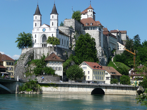
Aarburg is a town in the Swiss canton of Aargau, in the district of Zofingen. The town lies between Olten and Zofingen and was first mentioned in 1123. Since the other two cities are only about four kilometers away, it has always been a little overshadowed by them, but at least since the industrial revolution. In the Middle Ages, the town was able to assert itself above all thanks to its strategically favorable location, because here there is a narrow passage between the Aare and a rocky outcrop; that's why Aarburg was able to live off the customs revenue from the Gotthard route. Due to its location on a rocky spur, it was easy to defend, but it was captured by the Bernese troops as early as 1415 after a short siege. In the 16th and 17th centuries, the people of Bern and Zurich converted the city into a fortress, as it was located at the narrow point between the two Catholic cantons of Solothurn and Lucerne. Almost the entire city fell victim to the fire on May 4, 1840. The city was rebuilt afterwards, but not part of the fortress. In front of the castle, and therefore visible from afar, the new church was built in neo-Gothic style between 1842 and 1845.
By train
Aarburg-Oftringen station is only served by regional
trains from Olten to Langental-Bern and from Olten to
Zofingen-Lucerne. The easiest way to get here is via Olten,
where there is a Swiss railway junction.
In the street
The Rothrist and Oftringen motorway junctions on the A1 are both
around 3 kilometers from the city. The main road from Olten to
Zofingen-Lucerne bypasses the old town.
The old town is characterized above all by its uniform
development.
The Reformed parish church is located on the
rocky spur in front of the castle and together with it forms the
distinctive appearance of the town. It was built on the site of
the previous church that burned down in 1840 between 1842 and
1845 in the style of a neo-Gothic hall church according to plans
by Johann Jakob Heimlicher.
The castle was built in several
stages. The palas and the keep are high medieval. An early
baroque residential wing was added to the south in 1631. From
1659 it was gradually expanded into an artillery fortress.
Between 1415 and 1798 it was the seat of the Bern bailiff. Today
it serves as an educational institution.
Coin finds indicate a settlement by the Celts. In
Roman times, a road led from the Olten area to central Switzerland
via Aarburg. During the construction of a factory at the beginning
of the 20th century, a coin hoard was discovered, which mainly
contained coins from the reign of Emperor Tetricus I. The hoard of
coins was probably buried during the Bagaudian uprisings of 284/85.
It is not known exactly when the castle on the rocky outcrop
(today's Aarburg Fortress) was built. In any case, it was first
mentioned in 1123 as belonging to the Counts of Frohburg. From the
castle they administered the Amt of Aarburg, which included the
western part of today's district of Zofingen, but without the town
of Zofingen itself. In 1299, the Frohburg family sold the castle and
the Amt of Aarburg to the Habsburgs. The settlement at the foot of
the fortress was first explicitly referred to as a town in 1330.
Archaeological finds have shown that the city was probably founded
around 1312. Squeezed between the cities of Olten and Zofingen, both
of which are only four kilometers away, Aarburg was unable to
develop economically and has always remained a small town. The
people of Aarburg lived mainly from the customs revenue that trade
on the Gotthard route brought in.
After a short siege, the
Bernese conquered the town on April 20, 1415. From 1416 the bailiff
of the Aarburg office resided in the castle. In the 16th and 17th
centuries, the Bernese converted the castle into a fortress to
protect the connection between the reformed cities of Bern and
Zurich at the narrowest point of the Bernese dominion from attacks
by the Catholic neighbors. A harbor on the "Woog" has been occupied
since 1361. As a result, river navigation gained great economic
importance, especially during the 17th and 18th centuries.
On
March 10, 1798, the French took the town and fortress without a
fight. They dissolved the Aarburg office, and Zofingen took over the
regional administrative tasks within the new Helvetic Republic. The
newly created canton of Aargau took over the fortress in 1804, which
initially served as a prison and penitentiary. Among other things,
escape king Bernhard Matt was imprisoned there; since 1893 a
cantonal reformatory has been housed here. On May 4, 1840, a major
fire raged that destroyed most of the buildings and the church; 68
families were left homeless as a result. The town was rebuilt, but
without the main fortifications. A new church was built between 1842
and 1845 on the rocky outcrop in front of the fortress.
The
first textile factory went into operation as early as 1824. The
connection to the railway network took place on June 9, 1856 with
the opening of the Aarau-Olten-Zofingen-Emmenbrücke line; on March
16, 1857, the route to Herzogenbuchsee followed, which was extended
to Bern a little later. As a result, Aarburg developed into a
preferred industrial location. In the second half of the 20th
century, the community experienced another boost: thanks to the
construction of the motorways, even more companies settled and the
population doubled.
The community lies on the northern edge of the Wiggertal on the banks
of the Aare. The landscape is characterized by a narrow but steep rocky
spur that reaches to the river bank and seals off the valley. This is an
offshoot of the 664 meter high Säli, the westernmost part of the
Engelberg. At the narrowest point is the medieval old town. To the north
of this stretches a roughly one and a half kilometer long river plain,
which is also delimited by a bottleneck at the opposite end.
The
Wigger forms the southern municipal boundary. Parallel to this, about
five hundred meters further north, flows the Aarburger Mühletych, an
artificial tributary created at the beginning of the 16th century. It
was once used to drive mill wheels, later as a hydropower supplier for
industry. The Mühletych flows into the Aare near the old town, albeit
against the direction in which it flows. Since the river has a kink at
this point and the outflow is impeded by the continuation of the Säli
rock spur, this creates a large, slowly rotating eddy, known as the Aare
Waage or «Woog». Flotsam can remain in this vortex for days; This made
it very easy to collect rafts, which is why Aarburg was once an
important starting point for rafting.
The area of the
municipality is 441 hectares, of which 135 hectares are wooded and 212
hectares are built over. The highest point is below the summit of the
Säli at 620 meters, the lowest point at 393 meters on the Aare.
Neighboring communities are Olten in the west and north, Starrkirch-Wil
in the north-east, Oftringen in the east and Rothrist in the south.
The blazon of the city coat of arms reads: "Gold, two-tower, crenellated black castle, covered with a small golden cross on the lower right, on the lower left tower a black eagle." The coat of arms was created before 1415 in the form of a standard. The eagle can be traced back to a folk etymological interpretation of the Middle High German name aar. The coat of arms was a motif on a Pro Juventute stamp in 1978.
The assembly of voters, the municipal assembly, exercises legislative
power. The executive authority is the five-member municipal council. He
is elected by the people in a majority procedure, his term of office is
four years. The municipal council leads and represents the municipality.
To this end, it implements the resolutions of the municipal assembly and
the tasks assigned to it by the canton. The five municipal councils for
the 2022-2025 term of office are:
Hans-Ulrich Schär (independent),
mayor
Martina Bircher (SVP), Vice-Chairman
Rolf Walser (SP)
Dino Di Fronzo (FDP)
vacant
The District Court of Zofingen is
responsible for legal disputes in the first instance. Aarburg belongs to
the circle of justices of the peace XV (Rothrist).
Aarburg
introduced the residents' council in 1972, but abolished it again in
1989 and returned to "proper community organization" with community
meetings.
According to the company structure statistics collected in 2015 (STATENT), there are around 3,100 jobs in Aarburg, of which 0.4% are in agriculture, 31.9% in industry and 67.7% in the service sector. The municipality was chosen as a location by over 300 companies because of its favorable location at the A1/A2 motorway junction and the nearby Olten railway junction. Among others, the metal and kitchen construction company Franke and the underwear manufacturer Zimmerli have their headquarters in Aarburg.
The Aarburg-Oftringen SBB train station is right on the municipal
boundary. Regional trains run to Olten, Langenthal and Lucerne. The
train station is the terminus of a Limmat Bus line to Zofingen train
station and a BOGG bus line to Olten and Trimbach. At weekends, night
buses run from Olten train station via Aarburg to Oberbuchsiten and
Vordemwald.
Aarburg is just a few minutes' drive from the
Rothrist and Oftringen junctions of the A1 motorway on the main road 2.
Before the 1800-metre-long bypass road was opened, more than 30,000
vehicles squeezed through the narrow town, more than, for example, on
the Gotthard motorway. After a planning phase lasting more than 15
years, construction work began in September 2004. The new road was
opened to traffic on November 21, 2007. More than half runs in two
tunnels.
The municipality has six kindergartens and three school buildings. All school types of compulsory elementary school are taught here: primary school in the school buildings at Höhe and Hofmatt, and secondary school and junior high school in the school building at Paradiesli. The district school is run in the neighboring municipality of Oftringen. The nearest high school is the Kantonsschule Zofingen.
Franz Theodor Aerni (1853–1918), painter
Albrecht Eierblust
(1770–1841), government councilor and judge
Ivan Dreyfus (1884–1975),
soccer player
Adolf Gloor (1884–1944), National Councilor and trade
unionist
Marlies Graf-Dätwyler (1943–2020), filmmaker
Fabienne
Hoerni (born 1974), jazz musician
Jacques-Barthélemy Micheli du Crest
(1690-1766), politician and surveyor, imprisonment 1746-1766 at the
Aarburg
Arnold Niggli (1843–1927), music historian and critic
Friedrich Niggli (1875–1959), composer and music teacher
Isaac
Steiger (1669–1749), mayor of Bern
Paul Arnold Walty (1881–1969),
soccer player
Adolf Welti (1876–1951), National Councilor and doctor