Location: Canton of Valais Map
Length: 15 mi (24 km)
Thickness: 900 meters
Age: 60,000 years
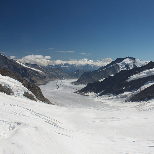
The Grosser Aletsch Glacier, also known as the Great Aletsch
Glacier or simply Aletsch Glacier (Grosser Aletschgletscher in
German), is the largest and longest glacier in the Alps and the
entirety of continental Europe. Situated in the eastern Bernese Alps
within the Swiss canton of Valais, it stretches approximately 23
kilometers (14 miles) in length, with a volume of around 15.4 cubic
kilometers and a surface area of about 81.7 square kilometers as of
the early 2010s. This colossal river of ice originates in the
Jungfrau region at elevations around 4,000 meters, where it forms
from the convergence of four major firn fields: the Grosser
Aletschfirn, Jungfraufirn, Ewigschneefeld, and the smaller
Grüneckfirn, meeting at Konkordiaplatz—a vast ice plateau where the
glacier reaches its maximum thickness of up to 905 meters. From
there, it flows southward into the Rhône Valley, eventually giving
rise to the Massa River. Weighing an estimated 11 billion tonnes,
the glacier's ice takes roughly 400 years to travel from its
accumulation zone to the tongue, where meltwater emerges. Its
immense scale and dynamic nature have made it a focal point for
scientific study, tourism, and environmental concern, particularly
as a barometer for climate change.
The glacier's name first
appears in historical records as "Alech" in 1231, with the modern
form "Aletsch" documented by 1460, though its etymology remains
uncertain, possibly echoing ancient local dialects. It forms the
heart of the UNESCO World Heritage Site Swiss Alps Jungfrau-Aletsch,
inscribed in 2001 and expanded in 2007 to cover 82,400 hectares,
recognizing its outstanding geological, ecological, and aesthetic
value. This protected area encompasses not only the Aletsch but also
surrounding peaks and ecosystems, highlighting the region's role in
illustrating mountain formation and glacial processes.
Geological Formation and Early History
The
Grosser Aletsch Glacier's origins trace back to the Pleistocene
epoch, shaped by the cyclical advance and retreat of ice during
multiple ice ages. Its current configuration is believed to have
formed around 12,000 years ago, at the end of the Würm
glaciation—the last major ice age in the Alps. During the peak of
the last ice age, approximately 18,000 years ago, the glacier was
part of a vast ice sheet that blanketed the Swiss Alps. Ice covered
mountain ridges between peaks like the Bettmerhorn and Riederhorn,
with only the highest summits protruding above the frozen expanse.
At that time, the glacier's terminus extended far into the Rhône
Valley, and its edge reached nearly to Riederfurka, carving deep
U-shaped valleys and depositing massive moraines that still define
the landscape today.
Holocene records, derived from radiocarbon
dating of organic materials in moraines and lake sediments, reveal
periodic fluctuations. Significant advances occurred between 1200
and 1110 BCE, 850 and 750 BCE, and 350 and 250 BCE, driven by
cooler, wetter climatic conditions that increased snow accumulation.
These episodes expanded the glacier's reach, damming valleys and
forming temporary lakes. For instance, the Märjelensee—an ice-dammed
lake along the glacier's edge—was a recurring feature, known for
dramatic outbursts of meltwater that flooded downstream valleys,
posing risks to local settlements as late as the 19th century.
Around 11,000 years ago, as the climate warmed post-ice age, the
glacier began a general retreat, though interspersed with minor
readvances.
The surrounding geology underscores the Alps'
tectonic history: the region records the uplift and compression from
the collision of the African and Eurasian plates, forming the High
Alps. Features like overdeepened beds (where ice has eroded basins
below sea level in places) and classic glacial landforms—crevasses,
meltwater gorges, and forelands—provide a textbook example of
glacial erosion and deposition.
Historical Fluctuations: The
Little Ice Age and Beyond
The glacier's history from the medieval
period onward is better documented through written accounts, maps,
and early scientific observations. During the Little Ice Age—a
period of global cooling from roughly the 14th to the mid-19th
century—the Aletsch experienced its most recent major expansion. By
around 1860, it reached its Holocene maximum, extending
approximately 3 kilometers longer than today and with its surface
200 meters higher, encroaching near the Aletsch Forest. At this
peak, neighboring glaciers like the Oberaletsch and Mittelaletsch
were directly connected to the main body, forming an even more
extensive system. This advance dammed valleys, creating hazards like
the Märjelensee outbursts, which attracted early tourists around
1900 to witness calving icebergs.
The mid-19th century marked a
turning point. As the Little Ice Age waned and industrialization
accelerated global warming, the glacier began a sustained retreat.
Systematic measurements started in the late 19th century: lengths
were first recorded for nearby glaciers like the Lower Grindelwald
in 1881, and for the Aletsch and Fiesch in 1892. Since 1870, the
Aletsch has lost over 3.5 kilometers in length, with retreat rates
accelerating from 10-20 meters per year historically to at least 50
meters annually in recent decades. A record single-year retreat of
114.6 meters occurred in 2006. Ice thickness has decreased by more
than 100 meters in some areas since 1850, and the glacier has shed
over 5 cubic kilometers of volume—about a quarter of its 1880 mass.
From 1980 to 2016 alone, it shortened by 1.3 kilometers and thinned
by over 300 meters.
Human interactions add poignant chapters. In
1926, four hikers perished on the glacier after becoming disoriented
in bad weather, freezing to death; their fate was reconstructed in
2014 using glacial simulations. Tourism boomed in the 19th century,
drawn by the glacier's majesty, with nearby Grindelwald's
development tied to glacial attractions. Peaks like Agassizhorn
honor Louis Agassiz, the 19th-century Swiss-American geologist who
pioneered glaciology and proved the existence of past ice ages.
Scientific and Cultural Significance
The Aletsch's history is
invaluable for understanding glacial dynamics and climate. As
Europe's most glaciated region, it offers insights into alpine
formation, with features like the overdeepened Konkordiaplatz bed
rivaling polar ice thicknesses. Ongoing retreat exposes successional
ecosystems, from bare rock to alpine meadows, illustrating
biological adaptation to climate change. Culturally, it has inspired
European art, literature, and mountaineering since the Romantic era,
symbolizing nature's sublime power.
Future Projections and
Challenges
Models predict continued dramatic retreat under
warming scenarios. By the end of the 21st century, the Aletsch could
lose much of its length and volume, with debris accumulation
potentially slowing but not halting the melt. Scientists warn of new
risks, such as forming meltwater lakes that could cause floods as
ice destabilizes. Despite this, the glacier remains a resilient
indicator of long-term climate trends, its history a stark reminder
of environmental change.
Location and Topographic Setting
The glacier is situated on
the southern slope of the Jungfrau massif, part of the Bernese Alps,
at coordinates roughly centered around 46°28'N, 8°02'E. It begins at
elevations exceeding 4,000 meters above sea level (m a.s.l.), with
its highest point around 4,160 m near the Jungfrau and Aletschhorn
peaks. The glacier descends southeastward before curving southwest,
terminating at its tongue around 1,560–1,650 m a.s.l. in the Rhône
Valley, just above the Aletsch Forest nature reserve. This location
places it within a deeply incised alpine valley system, bordered by
towering peaks such as the Jungfrau (4,158 m), Mönch (4,107 m), and
Aletschhorn (4,195 m) to the north, and the Bietschhorn (3,934 m) to
the south. Nearby glaciers include the Fiescher Glacier and
Finsteraar Glacier, which flow parallel or adjacent, contributing to
the region's extensive glaciation—the most glaciated area in the
European Alps.
The glacier's position in the Alps' rain shadow
influences its accumulation, with precipitation primarily from
westerly and northwesterly weather systems feeding its upper firn
fields. It drains into the Massa River, a tributary of the Rhône,
highlighting its role in the regional hydrology.
Formation
and Structure
The glacier forms from the convergence of four
primary firn fields (perennial snowfields) at Konkordiaplatz, an
expansive ice plateau at about 2,700 m a.s.l. that could encompass a
mid-sized Swiss town. These include:
Grosser Aletschfirn:
From the southwest, originating near the Aletschhorn.
Jungfraufirn: From the northwest, below the Jungfrau peak.
Ewigschneefeldfirn (or Ewigschneefäld): From the north.
Grüneggfirn: Occasionally noted as a contributing field.
This
merger creates the main trunk, divided into the Great Aletsch
(primary branch), Middle Aletsch, and Upper Aletsch. The Middle
Aletsch descends from the Aletschhorn and joins opposite Märjelen
Lake, a small glacial lake on the glacier's northern margin. The
structure features an overdeepened bed at Konkordiaplatz, where ice
thickness exceeds that found elsewhere outside polar regions.
Geographical Features
The glacier exhibits classic alpine
glacial morphology. Its surface is marked by two prominent medial
moraines—dark bands of rock debris running longitudinally, formed
where tributary glaciers merge. These moraines, along with lateral
moraines, carry debris from surrounding peaks, giving the lower
sections a grayish appearance due to exposed rock. Crevasses
fracture the ice in the accumulation and ablation zones, while
meltwater gorges and channels drain surface water. The glacier has
carved U-shaped valleys, such as the Lauterbrunnental to the north,
and created forelands with depositional features like end moraines
from past advances. The tongue, covered in debris, ends below the
treeline, feeding the Massa Gorge.
Surrounding Environment
The glacier is embedded in a diverse alpine ecosystem. To the north
lies the Jungfrau-Aletsch-Bietschhorn protected area, encompassing
high peaks, meadows, and forests. Southward, it borders the Aletsch
Forest, a subalpine woodland reserve. The region features
topographic breaches like the Lötschenlücke and Grünhornlücke,
allowing ice flow between valleys. Human infrastructure includes
viewpoints like the Eggishorn (2,927 m) and Bettmerhorn, offering
panoramic vistas, and the Konkordia Hut for mountaineers.
Dynamics and Changes
Flow velocity varies: up to 200 m per year
at Konkordiaplatz, slowing to 80–90 m per year lower down. However,
the glacier is retreating rapidly due to climate change, losing 1.3
km in length since 1980, 3.2 km since 1870, and over 300 m in
thickness. Since the Little Ice Age maximum around 1850, it has shed
more than 5 km³ of ice. Models predict further retreat, exposing
more bedrock and altering the landscape.
Environmental and
Geological Significance
As a remnant of the last Ice Age (formed
over 12,000 years ago), the Aletsch Glacier preserves a record of
alpine uplift and compression. It serves as a critical water
reservoir for irrigation and hydropower, while its retreat
underscores global warming impacts. The site's UNESCO status
highlights its value for scientific study and tourism, drawing
visitors for hiking, skiing, and glacial excursions.