Location: Canton of Valais, Pennine Alps Map
Altitude: 4478 meters (14690 feet)
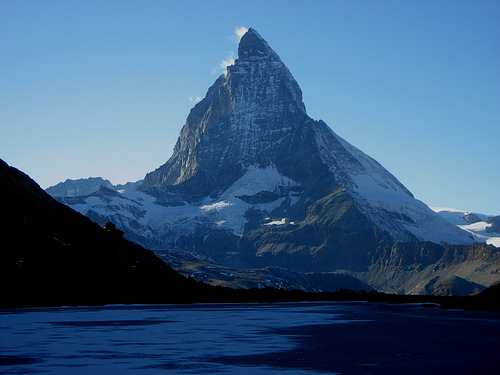
The Matterhorn (Italian Monte Cervino or Cervino, French Mont
Cervin or Le Cervin, Valais German Hore or Horu) is 4478 m above sea
level. M. one of the highest mountains in the Alps. Because of its
striking shape and its climbing history, the Matterhorn is one of
the most famous mountains in the world. For Switzerland it is a
landmark and one of the most photographed tourist attractions.
The mountain is in the Valais Alps between Zermatt and
Breuil-Cervinia. The east, north and west walls are on Swiss
territory, the south wall on Italian territory.
The
Matterhorn Museum in Zermatt provides interesting information about
the Matterhorn.
In general, the mountain peaks in the mountains got their names late,
but the pass crossings and Alps below usually got their names earlier.
In 1545, Johannes Schalbetter called today's Theodul Pass "Mons Siluius"
(in German translated as Salasserberg) or in German as Augsttalberg. By
Augsttal we mean the valley of Aosta (Latin: Augusta Praetoria
Salassorum), the Aosta Valley.
“Siluius” was then most likely
misinterpreted in folk etymology, via supposedly Latin “silvius” and
“silvanus” to French and Italian “Cervin/Cervin(i)”. In 1581 the
Matterhorn was first mentioned as Mont Cervin, like Mons Silvanus and
Mons Silvius later. In 1682, Anton Lambien named today's Matterhorn
Matter Dioldin h[orn] (Matterhornspitze) to differentiate it from the
pass of the same name, which was still called "Matterjoch" until the
middle of the 19th century (for example on the Dufour map).
In
the local population, the mountain is also simply called ds Hore (“the
Horn”, Zermatt dialect) or ds Horu (“the Horn”, Upper Valais dialect).
The Matterhorn is a Karling, and its characteristic shape was created
by erosion and glacial wear during the Ice Ages. The Matterhorn is part
of the Dent-Blanche nappe of the Lower Eastern Alps, i.e. a piece of
rubble of an Eastern Alpine cap rock pushed far to the west onto the
Pennine nappes of the Western Alps. The lower rock layer of the
Matterhorn, which extends to the height of the Hörnlihütte, is Penninic,
i.e. western Alpine. The horn itself, which is small in comparison, sits
on this base and belongs to the Dent Blanche nappe, namely the lower
part up to the "shoulder" belongs to the Arolla series of orthogneisses
and metagabbros and the upper part belongs to the Valpelline series of
highly metamorphic paragneisses the Dent Blanche ceiling. Simply put,
the Matterhorn consists of two different packages of rock lying
diagonally on top of each other. Today's Matterhorn Glacier only emerged
again in the pessimum of the migration period after the optimum of the
Roman period.
A special feature is the characteristic “Matterhorn
cloud”. It is an outstanding example of a type of cloud that
meteorologists call a banner cloud: Like a mighty flag, the cloud forms
on the leeward side of the summit as an almost constant companion of the
mountain. The most plausible explanation for its formation is the
following: The Matterhorn towers over the surrounding mountains like a
tower, so that leeward vortices form on it, which carry moist air from
the valley upwards, where condensation and cloud formation occurs. Once
the summit level is reached, the cloud is captured by a horizontal
branch of the leeward vortex, which leads to the typical plume shape
(leeward vortex hypothesis).
Since 1857, several unsuccessful attempts have been made to climb
the Matterhorn, mostly from the Italian side. In 1862, John Tyndall
climbed the southwest shoulder, today's Pic Tyndall, for the first
time with guides Johann Josef Benet, Anton Walter, Jean-Jacques and
Jean-Antoine Carrel. Continuing the climb along the Lion Ridge
seemed impossible to them.
To the first climber of the
Matterhorn, Edward Whymper, the Lion Ridge still seemed unfeasible.
In total he had already failed seven times and survived, among other
things. a fall of over 60 meters. Whymper therefore tried to
persuade his friend Jean-Antoine Carrel to climb from the Zermatt
side. Carrel insisted on ascending from Italy.
In July 1865,
Whymper learned by chance from an innkeeper in Breuil-Cervinia that
Carrel had set off for the Liongrat again - without notifying
Whymper. Whymper felt deceived and rushed to Zermatt to put together
a group for an immediate attempt over the Hörnligrat. On July 14,
1865, Whymper's seven-man rope team made the first ascent. The group
climbed over the Hörnligrat to the shoulder; Further up, in the area
of today's fixed ropes, it moved onto the north face. Edward Whymper
was the first to reach the summit because he cut himself off the
rope before the summit and ran ahead. He was followed by the
mountain guide Michel Croz (from Chamonix), Reverend Charles Hudson,
Lord Francis Douglas, Douglas Robert Hadow (all from England) and
the Zermatt mountain guides Peter Taugwalder father and Peter
Taugwalder son. They saw Carrel and his group far below at Pic
Tyndall.
During the descent of the first climbers, the front four
of the rope team (Croz, Hadow, Hudson and Douglas) fell fatally over
the north face above the “shoulder”. From July 15, 1865, Josef Marie
Lochmatter set out with rescue teams several times to provide first
aid to the four people who had fallen. On July 19, a rescue team
recovered the bodies of Croz, Hadow and Hudson from the Matterhorn
Glacier. Douglas’ body was never found.
On July 17th, Carrel,
together with Jean-Baptiste Bich and Amé Gorret, also managed to
climb over the Liongrat to the summit. The three traversed from the
north end of the Italian shoulder through the uppermost west face
onto the Zmuttgrat (so-called Galleria Carrel) and completed the
ascent via this.
Round anniversaries of the first ascent of
the Matterhorn have been celebrated. For the 100th anniversary on
July 14, 1965, Swiss television showed an international live
broadcast of a Matterhorn ascent with the participation of mountain
reporters from the BBC and RAI. On June 30, 1965, Swiss television
showed the specially produced documentary Bitter Sieg: The
Matterhorn Story (director: Gaudenz Meili). On the occasion of the
150th anniversary, a countdown clock was set up on the train station
square in Zermatt on July 14, 2015, and in December 2014 a meeting
point for the anniversary year was set up in the center of the town
(“Matterhorn Plaza”).
On July 22, 1871, six years after
Whymper, British alpinist Lucy Walker became the first woman to
climb the Matterhorn. In 1869, Isabella Straton and Emmeline Lewis
Lloyd attempted the climb as an all-female team; they failed shortly
before the summit. In 1871, Anna Voigt from Frankfurt also climbed
the Matterhorn; At that time she was one of the first women in the
Frankfurt am Main section of the German Alpine Club. Yvette Vaucher
(* 1929) is the first woman to climb the north face of the
Matterhorn.
By far the most frequently used ascent route is the Hörnligrat from Zermatt via the Hörnlihütte (northeast ridge, ZS+). It represents the so-called normal route, i.e. the easiest ascent. At an altitude of 4003 meters, northeast below the summit, there is the Solvayhütte with ten emergency camps, which is serviced from the Hörnlihütte and is a bivouac for emergencies such as sudden weather changes and delays in time. There are further ascent routes on the southwest ridge via the church-roof-like Pic Tyndall (also called Liongrat or Italian Way, ZS+), on the northwest ridge (Zmuttgrat, S) and on the southeast ridge (Furggengrat, SS, little used). There is also an ascent route through the forbidding north face, which is occasionally used by specialists, e.g. Walter Bonatti, is elected.
Northeast ridge “Hörnligrat” (normal route)
Difficulty: ZS+,
with UIAA grade III+ rock climbing
Time required: 5-6 hours
Starting point: Hörnlihütte (3260 m)
Valley location: Zermatt
(1608 m)
First ascent: July 14, 1865 by Edward Whymper, Reverend
Charles Hudson, Douglas Robert Hadow, Lord Francis Douglas, with the
mountain guides Michel-Auguste Croz, Peter Taugwalder and his son
First winter ascent: January 31, 1911 by Charles F. Meade with Josef
Lochmatter and Josef Pollinger
First ascent: 1898 by Wilhelm
Paulcke
Northwest ridge or “Zmuttgrat”
Difficulty: S, with
IV. UIAA grade rock climbing
Time required: 6-7 hours
Starting
point: Hörnlihütte (3260 m)
Valley location: Zermatt (1608 m)
First ascent: September 3, 1879 by Albert Mummery with Alexander
Burgener, Augustin Gentinetta and Johann Petrus
First solo
ascent: September 1, 1906 by Hans Pfann
Southeast ridge or
“Furggengrat”
Difficulty: SS, with UIAA grade V+ rock climbing
Time required: 7 hours
Starting point: Bivacco Bossi (3345 m)
Valley location: Breuil-Cervinia (2006 m)
First ascent: 1905 by
V.J.E. Ryan led by Josef Lochmatter
First winter ascent: February
10, 1998 by Giorgio Carrozza, Andrea Perron and Augusto Tamone
Southwest Ridge or “Lion Ridge”
Difficulty: ZS+, with UIAA
grade III+ rock climbing
Time required: 4-5 hours
Starting
point: Rifugio Jean-Antoine Carrel (3829 m)
Valley location:
Breuil-Cervinia (2006 m)
First ascent: July 17, 1865 by
Jean-Antoine Carrel and Jean-Baptiste Bich
First winter ascent:
March 17, 1882 by Vittorio Sella, Jean Antoine, Jean Baptiste and
Louis Carrel
In 1992, Hans Kammerlander and Diego Wellig managed
to climb the Matterhorn four times over its four ridges in 23 hours
and 26 minutes.
East wall
Difficulty: SS
Time required: 14 hours
Starting point: Hörnlihütte (3260 m)
Valley location: Zermatt
(1608 m)
First ascent: 18/19. September 1932 by Enzo Benedetti,
Giuseppe Mazzotti with Maurice Bich, Louis and Lucien Carrel and
Antoine Gaspard
First winter ascent: 27th/28th February 1975 by
René Arnold, Guido Bumann and Candide Pralong
Ski descent: May
14, 1975 by Toni Valeruz
North wall
Difficulty: SS, with
V. UIAA grade rock climbing
Time required: 12-14 hours
Starting point: Hörnlihütte (3260 m)
Valley location: Zermatt
(1608 m)
First ascent: July 31/1. August 1931 by Franz and Toni
Schmid
First solo ascent: July 22, 1959 by Diether Marchart in 5
hours
First winter ascent: 3rd/4th February 1962 by Hilti von
Allmen and Paul Etter
First winter ascent: February 1965 by
Walter Bonatti, on a new and more difficult route, with 3 bivouacs
First ascent by a woman: July 14, 1965 by the Swiss Yvette Vaucher
fastest solo ascent by Dani Arnold in 1h 46min on April 22, 2015
West wall
Difficulty: SS, with UIAA grade V+ rock climbing
Time required: 12 hours
Starting point: Schönbielhütte (2694 m)
Valley location: Zermatt (1608 m)
First ascent: August 13, 1962
by Renato Daguin and Giovanni Ottin
First winter ascent: 10/11.
January 1978 by Rolando Albertini, Marco Barmasse, Innocenzo
Menabreaz, Leo Pession, Arturo and Oreste Squinobal and Augusto
Tamone
First solo ascent: September 1983 by Jacques Sangnier
(this is, however, questionable)
South wall
Difficulty:
SS+, with UIAA grade V+ rock climbing
Time required: 15 hours
Starting point: Rifugio Duca degli Abruzzi all’Oriondé (2802 m)
Valley location: Breuil-Cervinia (2006 m)
First ascent: November
13, 1983 by Vittorio de Tuoni and Marco Barmasse
2,500 to 3,000 mountaineers try to conquer the summit every season,
and on peak days over 100 alpinists. 70% of alpinists choose the easiest
and best-known route via the Hörnligrat. Approximately 80 rescue
missions must be carried out by helicopter each season.
Since the
first ascent, not a year has passed without a fatal accident on the
Matterhorn. Eight to ten people have fatal accidents every year. Since
the first ascent more than 150 years ago, over 500 people have died on
the Matterhorn, the majority of them on the Swiss side. There is no
other mountain in the world where so many mountaineers die. Between 1981
and 2011, 223 alpinists died on the Swiss side, 207 of them from falls,
5 from falling rocks, 3 each from frostbite, from falling on the rope or
as a result of a search operation. 21 fallen alpinists have not yet been
rescued and are still missing.
A dead skier found on the mountain
in 2005 was identified in 2018 as the Frenchman Joseph Leonce Le Masne
(* 1919), who disappeared in 1954.
The Italian Bruno Brunod took 2 hours and 12 minutes to complete the
climb in 1995. The Spaniard Kilian Jornet beat this record in 2013,
climbing the mountain from Italy in 1 hour and 53 minutes. Including the
descent, Jornet achieved a time of 2 hours and 52 minutes.
On
April 22, 2015, the Swiss Dani Arnold beat Ueli Steck's previous record
from 2009 by ten minutes on the north face of the Matterhorn. He
completed the fastest solo ascent of the Matterhorn north face in 1 hour
46 minutes.
The Zermatt mountain guide Richard Andenmatten has
climbed the Matterhorn over 850 times.
Zermatt mountain guide
Ulrich Inderbinen climbed the Matterhorn 371 times, most recently at the
age of 89.
The Geneva painter Albert Gos, a great admirer of the high mountains,
became, so to speak, a “court painter” of the Matterhorn.
In 1908,
the striking pyramid-shaped summit head encouraged Theodor Tobler and
his cousin Emil Baumann to give the Swiss chocolate “Toblerone” its
distinctive shape.
In 2005, the Valais writer Pierre Imhasly created
a literary monument to the Matterhorn in his long poem
Maithuna/Matterhorn.
It is the namesake of Princeton University's
Matterhorn Project, which began in 1951 and is the forerunner of today's
Princeton Plasma Physics Laboratory for research into nuclear fusion and
its applications. Based on the project, the Wendelstein merger projects
emerged.
In 1959, a 1:100 scale replica of the Matterhorn opened at
the Disneyland Resort in California.
Since 2007, a 5.98 meter tall
replica of the Matterhorn has stood in the Miniatur Wunderland in
Hamburg's Speicherstadt.
In 1911, the German chemist Otto Hahn, the
later discoverer of nuclear fission and Nobel Prize winner, climbed the
Matterhorn and celebrated at the summit the successful industrial
production of radium 228 (mesothorium I), which he had already
discovered in Berlin in 1907.
A Matterhorn Railway, first planned in
1890, was intended to be a continuation of the Visp-Zermatt Railway
(opened in 1891) from Zermatt to the center of the Valais Alps - one
branch to the Gornergrat (3135 m above sea level), the other to the
Matterhorn. The Gornergrat Railway was built and opened on August 20,
1898; the Matterhorn Railway, on the other hand, was never built.
In
1950, Count Dino Lora Totino planned a cable car from Cervinia to the
summit of the Matterhorn. The Alpine Museum in Zermatt then sent an
objection with 90,000 signatures to the Italian government, which upheld
the protest and declared the Matterhorn a natural wonder worthy of
protection.
In 1988, Reinhold Messner became enraged during his climb
when he suddenly found a kiosk run by Art Furrer with souvenirs and
tabloids high up on the Matterhorn face and threatened to complain to
the “mayor”. The campaign was part of the show Do You Understand Fun?
and is considered one of the best episodes.
In 2012, Miss Switzerland
Linda Fäh, accompanied by her friend Lorena Oliveri, two mountain guides
and a camera team, climbed the summit. The then 24-year-old did not
recognize Switzerland's most famous mountain during the Miss Switzerland
election in 2009 and saw the campaign as compensation.
In 2014,
billionaire Richard Branson organized the Virgin Strive Challenge
charity event by bike, canoe and on foot from London to the Matterhorn.
His son Sam reached the summit, accompanied by two mountain guides, with
a stabbing headache and completely disoriented and had to be flown down
to the valley by helicopter. “Virgin” founder Branson observed the
events from a helicopter.
In 2017, the Nuremberg branch of the
Alternative for Germany party campaigned in the 2017 German federal
election campaign for better medical care in rural areas with an
internet election poster showing the Matterhorn with the slogan: Get
your country back.
From March 2018 to October 2019, a replica of the
Matterhorn hung upside down from the ceiling in the 100 meter high
airspace of the Gasometer in Oberhausen and was staged by several
projectors using a 3D projection.
Ama Dablam, a 6,814 m high mountain
in the Himalayas, is also called the 'Matterhorn of Nepal' because of
its shape.