Location: Canton of Bern Map
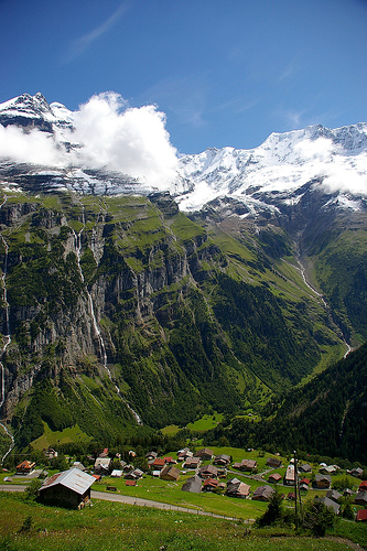
Gimmelwald is a small, traffic-free mountain village in Switzerland’s Bernese Oberland, perched dramatically on a cliff-edge terrace at about 1,363–1,367 meters (4,472–4,485 feet) above sea level in the upper Lauterbrunnen Valley. It sits between Stechelberg and Mürren, at the foot of the UNESCO World Heritage-listed Jungfrau-Aletsch Protected Area, with stunning views of the Eiger, Mönch, and Jungfrau peaks. As a classic Allemanic linear village and Walser settlement, it has preserved its traditional character more than almost any other Alpine community—thanks to geography, deliberate protection, and a resilient farming culture. Today it has roughly 100–130 residents (down from peaks of around 230 in the 1930s), and its 13 farms, flower-adorned chalets, and cowbells define a way of life that feels frozen in time.
Origins as a Walser Settlement (13th–14th Centuries)
Gimmelwald’s
history begins with the Walser migrations. The Walsers were an Alemannic
(Germanic) ethnic group from the Valais (Wallis in German), the high
alpine valley to the south. Starting around the 13th century and
continuing into the 14th, groups left their overcrowded homeland in
search of new farmland, driven by population pressure and shifting
climate that temporarily lowered glaciers and raised the tree line. They
crossed formidable snow-covered passes—including the Wetterlücke (about
3,170 m / 10,400 ft) between the Mittaghorn and Sattelhorn—with their
cattle herds and even church bells carried in special transport frames.
One bell from 1483 survives in Lauterbrunnen’s valley museum.
In the
Lauterbrunnen Valley, they founded terraced villages like Gimmelwald and
neighboring Mürren (the “Lötscher” people, named after the Lötschental
from which they came). They brought specialized high-mountain farming
techniques that made life possible at these elevations. For centuries,
the villagers felt more connected to their Valais roots than to the
people down in Lauterbrunnen; traces remain today in dialect, family
names (especially von Allmen and Feuz), and distinctive house styles.
The earliest written record of Gimmelwald dates to 1346, when Baron
Peter zum Turme of Niedergesteln in Valais sold his possessions in the
Lauterbrunnen Valley to the Interlaken Monastery in a bill of sale.
Medieval and Early Modern Life (15th–18th Centuries)
Life was
harsh and largely subsistence-based. The oldest surviving house in the
village dates to 1658—a typical two-family Walser chalet with a
natural-stone cellar for animals (cows and goats) and wooden upper
stories of massive spruce. Roofs were wooden shingles weighted with
heavy rocks against fierce winds and snow. Building one required immense
labor: trees cut and sawn by hand, materials carried up by villagers.
A devastating blow came in 1667 during the Black Death: roughly 60 % of
the population died within four months. Locals split into
factions—Interlaken authorities enforced isolation, but many
conservative “Anticontagonists” in the valley rejected quarantine,
viewing the plague as divine punishment and continuing visits, worsening
the toll. One house stood roofless for two years because its builders
perished.
Economically, the village supplemented farming with mining.
In 1638, a blast furnace was built at the “Schmelzi” (south of
Zweilütschinen) to process iron ore mined from the Dürlocherhorn above
the Rottal Glacier; operations ran until 1715. From 1705–1805,
silver-bearing galena and zinc ore were extracted at Trachsellauenen
(ruins still visible). Ore was sledded or carted down, sometimes taking
11–12 hours.
Agriculture evolved slowly. From around 1700, flax and
grain were grown and spun/woven at home. Potatoes arrived in the 18th
century and became a staple until after World War II. Hay was (and still
is) harvested by hand on steep slopes—labor-intensive work that one
family might do in half a day where a flatland machine would finish in
minutes.
Education arrived late: Gimmelwald opened its own school in
1789 for about 20 pupils.
19th Century: Early Tourism and
Infrastructure
Poverty remained severe; mid-century emigration to
“Carolina” (the United States) was common. In 1873, the population was
only 75.
Tourism began to change things. The Hotel Schilthorn was
built in 1869. In 1871, philosopher Friedrich Nietzsche and his sister
spent a summer holiday there; early visitors generated income for locals
as mountain guides, porters, and carriers (distinguished guests were
sometimes taken up the Schilthorn by sedan chair). Gravel for hotels in
Mürren was hauled up in sacks from the Sefinenlütschine for CHF 1 per
load. English poet Lord Byron’s writings on the Bernese Oberland also
drew attention. Women and children took up bobbin lace-making in winter;
an association still exists to organize designs, sales, and protection
of patterns.
Regional transport improved with the Bernese Oberland
Railway (BOB) in 1890 (Interlaken to Lauterbrunnen) and the
Lauterbrunnen-Mürren BLM railway/funicular in 1891.
20th Century:
Population Swings, Modernization, and Preservation
The 1930s saw the
highest population—around 230—because the economic crisis kept families
on the farms rather than seeking work elsewhere.
The real turning
point came in 1965 with the opening of the Schilthorn cableway
(Schilthornbahn), which stops in Gimmelwald. It brought enormous relief:
easier access to the valley for work, school, and apprentices; a tourism
boost for guesthouses and holiday flats; and a halt to feared
depopulation. Before this, the village was one of Switzerland’s poorest.
The cable car connected Gimmelwald to the revolving restaurant on the
2,970 m (9,744 ft) Schilthorn peak and made daily commutes possible.
Crucially, Gimmelwald avoided the fate of neighboring resorts. In
the mid-20th century, developers eyed it for a large ski village of
1,000 people. Led by a visionary local schoolmaster, residents
successfully lobbied to have much of the land reclassified as an
avalanche zone (partly strategic, as the risk is real but not total).
This government designation blocked major building projects while
allowing traditional farming to continue with subsidies. The village
remains car-free, with only pedestrian paths and agricultural vehicles
permitted.
The local school closed in 2010 due to low enrollment, but
in 2019 a cooperative bought the building to convert it into flats and
preserve it as a community center—preventing it from becoming another
holiday property and helping young families stay.
Gimmelwald
Today
The village’s 30.4 km² area is mostly steep pasture and forest.
Residents maintain a close relationship with nature: farming families
sell homemade cheese, produce, and garden goods directly. Traditions
like hand-scything hay, Alpine cow culture, and lace-making endure
alongside modest tourism. The Mountain Hostel (originally a 1563 farming
home) and other chalets welcome hikers and backpackers who value its
authentic, non-commercial feel.
Location and Coordinates
It lies at approximately 46.533°N 7.883°E
(more precisely around 46.547°N, 7.893°E), between the valley-floor
settlement of Stechelberg (to the south) and the higher village of
Mürren (to the northwest). The village sits at an elevation of
1,363–1,367 m (4,472–4,485 ft) above sea level, roughly 400–500 m above
the Lauterbrunnen Valley floor.
It forms part of the municipality of
Lauterbrunnen and is nestled at the foot of the Jungfrau-Aletsch
Protected Area, a UNESCO World Heritage site encompassing some of the
most spectacular high-alpine terrain in Europe.
Regional Context:
The Lauterbrunnen Valley
Gimmelwald occupies the western flank of the
Lauterbrunnen Valley (Lauterbrunnental), one of the deepest and most
dramatic U-shaped glacial valleys in the Alps. This glaciated
cleft—carved by ancient ice flows during the Pleistocene—is narrow
(rarely more than 1 km wide) with near-vertical limestone cliffs rising
up to 1,000 m on either side. The valley derives its name (“loud
springs”) from its 72 waterfalls cascading from the precipices.
The
valley floor lies at around 800–830 m elevation near Lauterbrunnen town,
while Gimmelwald’s terrace sits on a natural ledge formed by
differential erosion and glacial deposition. To the east, across the
chasm, tower the iconic Eiger (3,970 m), Mönch (4,107 m), and Jungfrau
(4,158 m) peaks of the Bernese Alps. Westward and southward rise the
Schilthorn massif and Gspaltenhorn. The entire setting is a classic
alpine landscape of jagged 4,000 m summits, hanging valleys, glacial
cirques, and meadows.
Topography and Terrain Features
The
immediate topography around Gimmelwald is steep and rugged. The village
clings to a narrow, sloping terrace with sheer drops on its eastern
edge—kick a ball too far and it plummets hundreds of meters to the
valley floor. The surrounding terrain features:
Alpine meadows
and pastures — tiny, hand-mowed plots used for hay to feed small herds
of cows.
Steep forested slopes and rocky outcrops.
High-relief
landscape — within a short radius, elevations range from ~829 m in the
valley to over 2,500 m on nearby ridges (average elevation in the mapped
area is ~1,564 m).
The village itself is laid out in a
traditional linear (Allemanic/Walser) pattern typical of historic alpine
settlements, with wooden chalets, flower-adorned balconies, and a
central cheese storehouse. Part of the area is designated an avalanche
zone, which has preserved its small scale and prevented large-scale
development.
Access is exclusively by aerial cable car (Luftseilbahn
Stechelberg–Mürren–Schilthorn) from Stechelberg or via hiking paths from
Mürren or the valley floor—no roads reach the village. This isolation
enhances its pristine, pedestrian-only character.
Climate and
Environment
Gimmelwald experiences a classic alpine climate (Köppen
Dfc/ET transition): cool, short summers and long, snowy winters with
high precipitation (~1,800–1,900 mm annually). Summer highs average
around 15–18°C (August ~18°C/64°F), while winter lows drop well below
freezing with heavy snowfall. The high elevation and exposure create
dramatic microclimates—fog can linger in the valley while the terrace
basks in sunshine.
The environment supports traditional mountain
farming (cattle, hay) alongside tourism. Much of the surrounding land is
unproductive (rock, scree, glaciers), emphasizing the harsh yet
beautiful high-alpine setting within the UNESCO-protected
Jungfrau-Aletsch-Bietschhorn region.
Panoramic Views and
Landscape Highlights
From Gimmelwald, the views are breathtaking:
across the valley to the Jungfrau massif (often with small avalanches
visible as “distant waterfalls”), down into the sheer-walled
Lauterbrunnen chasm with its waterfalls, and up toward the Schilthorn
cableway. The village feels suspended between sky and valley floor, with
chalets dotting flower-filled meadows against a backdrop of 4,000 m
peaks.
Gimmelwald's architecture embodies traditional Swiss alpine design, with clustered wooden chalets built from local timber and stone, featuring steeply pitched roofs to shed heavy snow and flower-boxed windows adding vibrant color. The village layout is linear, following a single winding path that serves as the main "street," lined with about 13 farms and a handful of guesthouses, barns, and small shops. Structures date primarily from the 18th-19th centuries, with some older elements reflecting Walser influences, such as elevated granaries on stilts to protect against rodents. The absence of cars preserves the pedestrian-friendly, cobblestone-like paths, while cowbells and roaming livestock enhance the pastoral ambiance. Key buildings include the historic schoolhouse (now a community center) and simple Protestant chapel, underscoring the village's modest, functional aesthetic.
Gimmelwald's attractions revolve around its natural surroundings and slow-paced lifestyle, making it ideal for immersive alpine experiences. The village serves as a starting point for numerous hiking trails, including the North Face Trail to Mürren or paths to the Sefinen Valley, offering views of glaciers and wildflowers. Visitors can observe traditional cheese-making at local farms or join cow parades during the seasonal alp descent (Almabtrieb) in autumn. The cable car ride from Stechelberg provides aerial perspectives of the valley's 72 waterfalls, while the village's guesthouses, like the historic Hotel Mittaghorn, offer cozy stays with home-cooked meals. Winter activities include snowshoeing and cross-country skiing, with the area transforming into a quiet snowy paradise. Cultural features include interactions with locals, who maintain Swiss traditions like yodeling and alpine farming, providing an authentic glimpse into rural life.
Gimmelwald is accessible year-round via cable car from Stechelberg (about 5 minutes, 10-15 CHF one-way), with connections from Lauterbrunnen by bus or train. No entry fees apply, but accommodations range from budget hostels (50-100 CHF/night) to family-run guesthouses; book in advance for peak summer (June-August) or winter seasons. The village has limited facilities—a small grocery, cheese shop, and a few eateries—so stock up in Mürren or Lauterbrunnen. Tips: Wear sturdy shoes for hikes; respect private farms by sticking to paths; visit early morning for fewer crowds and optimal light on the peaks. The Swiss Travel Pass covers transport; for sustainability, avoid single-use plastics in this eco-conscious area. Official resources: www.muerren.swiss or local tourism apps for trail maps.