Kamianets- Podilskyi is a historic medieval city situated in Khmelnytskyi Oblast of Ukraine.
Location: Khmelnytskyi Oblast
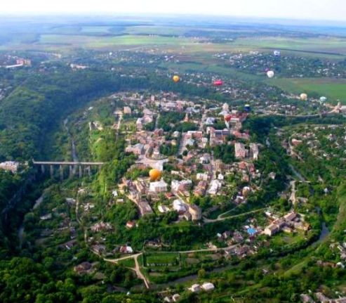
Kamianets-Podilskyi, often called the "Pearl of Podillia" or the "City of Seven Cultures," is a historic gem in western Ukraine's Khmelnytskyi Oblast. Perched dramatically on a limestone peninsula carved by the winding Smotrych River, it blends medieval fortifications, multicultural architecture from Polish, Lithuanian, Armenian, Ottoman, and Ukrainian influences, and breathtaking natural scenery. The city dates back to at least the 11th–12th centuries (with mentions as early as 1062) and served as a key defensive stronghold on the frontier of Christian Europe against Tatar and Ottoman incursions. Its Old Town is a state historical and architectural reserve with over 150 monuments, part of Ukraine's tentative UNESCO World Heritage list since 1989, and home to one of the country's Seven Wonders.
Kamianets-Podilskyi Castle (Fortress)
This is the undisputed star
attraction—a massive medieval stronghold often ranked among Europe's
best-preserved castles and voted one of Ukraine's Seven Wonders in
2007. Built initially in the early 14th century (with archaeological
roots possibly to the 12th–13th centuries during Kievan Rus'), it
sits atop a rocky peninsula surrounded on three sides by the deep
Smotrych River canyon, creating a natural moat that made it nearly
impregnable. Lithuanian Prince Yuriy Koriatovych granted it
Magdeburg rights in 1374; Polish kings like Casimir IV, Sigismund I,
Stephen Báthory, and others expanded it into a three-part fortress
(Old Castle, New Castle, and fortified Old Town) with thick
limestone walls, bastions, and artillery platforms.
Key
architectural features: Seven of the original 12 towers survive,
including the massive New Western (Great) Tower (built 1544, used
for artillery and later a printing press), the Pope's (Karmeliuk's)
Tower (a former arsenal and prison), the Water Tower (with a secret
well and tunnel), and the Black Tower (partially ruined). Walls
reach 13–14 meters high with crenellations, casemates, and
underground galleries. The complex includes a starosta's residence,
barracks, granaries, stables, and remnants of churches. The iconic
Castle Bridge (an 88-meter-long medieval engineering marvel, 17–27
meters high) connects the fortress to the mainland, originally
fortified with a round gate tower.
History and significance: It
withstood dozens of sieges (including 51 Tatar attacks) and fell
only twice—once to the Ottomans in 1672 (who held it for 27 years)
and briefly during other conflicts. Ottoman Sultan Osman II
reportedly marveled at its strength in 1621. Later uses included a
Russian prison (notably holding folk hero Ustym Karmaliuk) and
military headquarters. Today, it's a living museum with exhibits on
history, traditional crafts (pottery, archery, bread-baking),
festivals, and panoramic views from the towers over the canyon and
Old Town. A 2011 storm damaged one tower, but restorations continue.
Smotrych River Canyon
This dramatic natural landmark
encircles the castle and Old Town like a 40+ meter-deep limestone
gorge, with sheer cliffs, lush greenery, waterfalls, and the river
looping below. It provided the primary defense for the city and
fortress, turning the peninsula into an "island" fortress. Views
from the castle walls, bridges, or observation decks are
spectacular, especially at sunrise or sunset when mist rises from
the river. The canyon is part of the Podilski Tovtry National Nature
Park and enhances the fairy-tale, almost otherworldly atmosphere of
the historic core.
Old Town and Castle Bridge
The historic
center (a plateau almost fully ringed by the river) preserves a
medieval layout divided into Polish, Armenian, and Jewish quarters.
Cobblestone streets wind past pastel buildings, defensive towers,
and market squares. The Castle Bridge serves as the dramatic gateway
from the fortress into the town.
Polish Town Hall (Magistrate
House)
One of Ukraine's oldest town halls (parts from the
14th–16th centuries, completed 1703 in a Renaissance-Baroque-Gothic
mix), it stands in the Polish Market Square. It housed the Polish
magistrate, courts, and executions; later a police station and
firehouse. Now it features a city history museum and restaurant. Its
clock tower and ornate facade are photogenic landmarks. Nearby is
the Armenian Well (built by Armenians in the 17th century—legend
says the water was disappointingly salty).
Cathedral of
Saints Peter and Paul
This 16th–17th-century Roman Catholic
cathedral (Renaissance with Baroque elements) is the seat of the
Kamianets-Podilskyi Diocese. Its most striking feature is the tall
stone minaret (added by Ottomans when they converted it to a mosque
in 1672). After Polish recapture in 1699, the minaret was kept
intact—a rare example of tolerance—and topped with a golden statue
of the Virgin Mary. The interior holds tombs and artworks; services
are sometimes in Polish for the local minority.
Other Notable
Churches and Sites
Wooden Church of the Exaltation of the Holy
Cross (near the castle): A traditional Ukrainian wooden structure
(rebuilt after Turkish destruction and Soviet misuse as a cinema).
Commissioned by a Cossack leader for spiritual defense alongside the
fortress walls; offers a charming contrast to the stone castle.
Holy Trinity Church, St. George Cathedral (with blue domes,
Russian-style), and Dominican Monastery: Reflect the city's
Orthodox, Catholic, and monastic heritage. The Armenian quarter has
ruins of St. Nicholas Church and its own market.
Fortifications
and Gates: The Polish Gate, Russian Gate, Stephen Báthory
Gate/Tower, and remnants of walls/towers highlight the layered
defenses. The old synagogue (Renaissance-style, now a restaurant)
speaks to the once-thriving Jewish community.
The city is compact and walkable once you arrive, but reaching it
takes planning:
From Kyiv (most common entry point): Direct buses
(Pavluk’s or others) run frequently and take ~4–5 hours (~₴950 /
~$23). Trains (including Podilsky Express daytime options) take 7–9
hours and are cheaper but slower.
From Lviv: Buses or trains
(~4–9 hours depending on service); one popular route is the
overnight train.
International: Fly into Lviv (LWO) or Kyiv (if
services resume), then ground transport. Overland from
Poland/Romania is possible via bus/train. No commercial flights
operate within Ukraine due to closed airspace.
Local transport:
The old town and fortress are pedestrian-friendly. Taxis/Uber-style
apps or local buses work for outskirts. Renting a car is feasible
for day trips.
Best Time to Visit
May–September:
Ideal—lush green canyon, warm weather for hiking, open-air events.
Summer brings vibrant festivals (historical reenactments near the
castle, folk music, and occasional balloon events).
Shoulder
seasons (April–May or September–October): Fewer crowds, golden
foliage in the canyon, milder prices.
Winter: Magical with
snow-dusted towers but cold, slippery paths, and shorter days; some
outdoor sites close.
Aim for 2–3 full days (or 4 if adding day
trips) to soak it in without rushing.
Day Trip: Bakota
(Highly Recommended)
About 55 km away, Bakota is a submerged
ancient settlement and cave monastery complex on the Dniester River
reservoir. Boat tours or hikes reveal 12th-century rock-hewn caves
and stunning cliffs. It’s a peaceful, spiritual contrast to the city
bustle—book a private tour (~$50–100 including transport).
Suggested 3-Day Itinerary
Day 1: Arrive, explore castle (day +
night), cross bridge to old town.
Day 2: Canyon viewpoints,
churches, street art, and a relaxed dinner.
Day 3: Bakota day
trip or nearby villages (e.g., motoball or farmsteads for rural
insight).
Practical Tips for Visitors
Accommodation: 150+
options—budget hostels, mid-range hotels like Kleopatra, or boutique
spots in the old town. Book ahead in peak season.
Food & Drink:
Ukrainian classics (borscht, varenyky, grilled meats) in atmospheric
medieval-style cafés or riverside terraces. Try local Podolian wines
or craft beer. Vegetarians and internationals are well-catered for.
Money & Language: UAH cash is king (ATMs everywhere); cards widely
accepted. English is limited outside tourist spots—use Google
Translate or hire a guide (~₴500–1000/day).
Costs: Very
affordable—daily budget $30–60 excluding transport.
Other tips:
Comfortable walking shoes for cobblestones and hills. Download
offline maps. Respect local customs (church etiquette). Festivals
(historical reenactments) are magical if timed right.
Ancient and Kyivan Rus’ Origins (pre-11th century
– 1241)
Some historians speculate that a settlement existed here
as early as the 4th century BCE, possibly founded by the ancient
Dacians and named Petridava or Klepidava (“stone city,” from
Greek/Latin petra/lapis + Dacian dava). Archaeological evidence
confirms human activity in the area by the 12th–13th centuries,
including an early earthen fortress during Kievan Rus’ times.
The
city is first reliably documented in 1062 as part of the small
Principality of Terebovlia, later incorporated into the Principality
of Halych and the Kingdom of Galicia–Volhynia. Around 1230, Prince
Lev Danilovich of Galicia invited Armenians to settle and help
defend the eastern frontier; they received land grants and became a
key community. In 1240–1241 the city was sacked and largely
destroyed by Mongol forces under Batu Khan during the Mongol
invasion of Rus’.
Lithuanian and Early Polish Rule
(1360s–mid-17th century)
In the 1360s the city came under the
control of the Lithuanian Koriiatovych princes. By the mid-14th
century it passed to the Grand Duchy of Lithuania, and in 1352 (or
fully by 1430) it was incorporated into the Kingdom of Poland under
King Casimir III the Great. A wooden Rus’-era fortress was gradually
replaced in the 15th–16th centuries by a massive stone citadel.
Polish kings (notably Casimir IV Jagiellon, Sigismund I the Old,
Stephen Báthory, Sigismund III Vasa, and Władysław IV) repeatedly
expanded and modernized it — adding towers, walls, bastions, and the
iconic 88-meter Castle Bridge — to defend the Polish–Lithuanian
Commonwealth’s southeastern frontier against Tatar raids and Ottoman
expansion. It earned the nickname “the gateway to Poland” (brama do
Polski).
Key milestones:
~1374: Magdeburg city rights
granted (one of the first in Podillia).
1378: Seat of a Latin
Catholic diocese.
1432: Formal city rights confirmed by Sigismund
I the Old.
1434/1463: Capital of the Podolian Voivodeship and
proclaimed a royal city with duty-free status.
The city
flourished as an international trade and artisan center (second only
to Lviv), with self-governing Ukrainian, Armenian, and Polish
burgher communities. Early inhabitants were primarily Ukrainians and
Armenians; Poles and Jews settled in growing numbers. The fortress
repelled dozens of Tatar attacks (51 recorded in the 15th–17th
centuries) and an Ottoman siege in 1533.
During the Khmelnytsky
Uprising (1648–1654), the city endured multiple Cossack sieges (1648
by Maksym Kryvonis, 1651 by Ivan Bohun, 1652 and 1655 by Bohdan
Khmelnytsky and allies), though it held out until the major Ottoman
assault of 1672.
Ottoman Rule (1672–1699)
In 1672, a
massive Ottoman army (led by Sultan Mehmed IV, allied with Hetman
Petro Doroshenko and Crimean Tatars) besieged and captured the city
after a short but intense campaign; the fortress surrendered on 27
August. It became the capital of the Ottoman Podolia Eyalet (with
Kamianets as the central sanjak). The 27-year occupation brought
economic and demographic decline. Armenians were expelled (most
eventually resettled in Lviv and other Polish cities). The Turks
strengthened the fortress (adding a minaret to the Catholic
cathedral, later removed) but the city suffered. Poland
unsuccessfully tried to retake it in 1687.
The Treaty of
Karlowitz (1699) returned Podolia and Kamianets to the
Polish–Lithuanian Commonwealth under King Augustus II. The fortress
was further enlarged and regarded as the Commonwealth’s strongest.
Polish–Lithuanian Commonwealth (1699–1793) and Russian
Annexation
Under renewed Polish rule, the city retained its
defensive importance and multicultural character. A notable (and
controversial) event was the 1757 public disputation and burning of
Talmud copies ordered by Bishop Dembowski at the instigation of the
Frankists.
In 1793, during the Second Partition of Poland,
Kamianets-Podilskyi was annexed by the Russian Empire and became the
capital of Podolia Governorate (1797–1917). The fortress lost
military value and was converted into a prison (used for debtors,
criminals, political prisoners, and rebels like Ustym Karmeliuk, who
escaped three times). In 1812 the citadel (strengthened by the
Turks) was largely dismantled.
Population grew steadily despite
limited industry (no railway until 1914): ~3,450 in 1793, 16,000 in
1820, ~37,000 in 1893, and ~50,000 by 1914. It remained a cultural
hub of Podillia — home to an Orthodox brotherhood school (1589), a
theological seminary (1805, attended by figures like composer Mykola
Leontovych and writer Mykhailo Kotsiubynsky), one of the first
Prosvita societies in Russian-ruled Ukraine, and the Podilia Church
Historical-Archeological Society and museum (1890). Jews formed a
large community (over 48% in 1910), and the city was part of the
Russian Empire’s Pale of Settlement.
20th Century: World
Wars, Ukrainian Independence Struggle, and Soviet Rule
World War
I and Ukrainian Revolution (1914–1920): Occupied by Austria-Hungary
in 1915. After the 1917 Russian Revolution, it briefly belonged to
the Ukrainian People’s Republic (UNR) and Hetmanate. In 1919–1920 it
served as the de facto temporary capital of the UNR (after Kyiv
fell) and also hosted the Western Ukrainian National Republic
government. The Kamianets-Podilskyi Ukrainian State University was
founded in 1918. It was captured by Polish forces (1919–1920) during
the Polish–Soviet War before falling to the Red Army.
Interwar
Soviet Period (1921–1941): Incorporated into the Ukrainian SSR by
the 1921 Treaty of Riga. It was an okruha (1923–1930) and later
oblast capital (1937–1941). Population in 1926: 32,100 (45%
Ukrainian, 40% Jewish, 7% Russian, 6% Polish). The city suffered
during collectivization, peasant uprisings (reported in Western
media in 1927), and Stalinist repressions.
World War II and
Holocaust (1941–1944): German forces occupied the city on 11 July
1941. On 27–28 August 1941, Police Battalion 320, Einsatzgruppen
units under SS-General Friedrich Jeckeln, Hungarian troops, and
Ukrainian Auxiliary Police carried out the Kamianets-Podilskyi
massacre — one of the first large-scale mass murders of the “Final
Solution.” Approximately 23,600 Jews (local residents and Hungarian
deportees) were shot at a munitions depot on the city outskirts.
Overall, the Nazi regime murdered an estimated 40,000+ Jews from the
area. The city was liberated by the Red Army in 1944 after heavy
destruction.
Late Soviet Era (1945–1991): Postwar reconstruction
was slow; population reached 40,000 by 1959, 57,000 by 1970, and
84,000 by 1979 (71% Ukrainian, 21% Russian). It remained an
administrative and cultural center, with the old town and fortress
designated a state historical-architectural preserve in 1928
(expanded in 1977 and 1998).
Independent Ukraine
(1991–present)
Since Ukraine’s independence, Kamianets-Podilskyi
has thrived as a tourist magnet. The Kamianets National
Historical-Architectural Preserve protects the castle, old town, and
canyon setting. It was voted one of Ukraine’s Seven Wonders (2007)
and placed on UNESCO’s tentative World Heritage list. The historic
core features preserved Renaissance, Baroque, and Gothic buildings,
multiple churches (including the oldest Armenian church in Ukraine,
St. Nicholas, 1280), the town hall, and remnants of fortifications.
Population is approximately 97,000–100,000 (predominantly
Ukrainian). The city played an active role in the Orange Revolution
and Euromaidan. In 2022, following Russia’s full-scale invasion, it
sheltered thousands of internally displaced persons from eastern and
southern Ukraine.
The fortress and old town remain the city’s
heart — a living museum of medieval engineering, multicultural
heritage, and resilience.
Regional Context: The Podolian Upland
The city occupies the
Podolian Upland (also called the Volyn-Podolian Upland), a dissected
plateau in Ukraine’s forest-steppe zone. This upland consists of gently
rolling hills, small plateaus, and river valleys formed primarily from
sedimentary rocks—especially late Silurian and Miocene limestone. A
defining feature of the Podolian Upland is the Tovtry (or Medobory),
elongated limestone ridges that represent ancient coral-reef formations
from the Miocene epoch. These create a distinctive “ridge-and-valley”
landscape and are protected within the Podilski Tovtry National Nature
Park, one of Ukraine’s largest national parks, which encompasses parts
of the Khmelnytskyi and Kamianets-Podilskyi raions and includes numerous
cultural and geological monuments near the city.
The upland’s
elevation generally ranges from about 200–400 m above sea level; local
spot elevations around Kamianets-Podilskyi vary from roughly 136 m in
the river valley to 299 m on the surrounding plateaus, with an average
city elevation of approximately 219–360 m depending on the reference
point.
The Smotrych River and Its Iconic Canyon
The Smotrych
River (168 km long, drainage basin ~1,800 km²) is the dominant
hydrological feature. It flows through the city in a tight, meandering
loop that has carved a deep, narrow canyon—a natural monument formed
over millions of years by river erosion into the limestone bedrock. The
canyon’s steep cliffs rise 40–50 m (sometimes higher) above the
riverbed, which narrows to just 10–15 m wide in places. The old town and
castle sit on a high rocky plateau/peninsula almost completely encircled
by this canyon on three sides, with the fourth side historically
fortified by the castle itself. This topography made the site virtually
impregnable and earned the city its reputation as one of Europe’s most
naturally fortified locations.
In medieval times, the river could
flood the canyon rapidly (within hours), turning the area into a natural
moat. Today the Smotrych is calmer but still features seasonal
waterfalls, lush riparian forests, and small settlements clinging to the
canyon floor. The river is part of the broader Dniester basin;
downstream sections are designated as a Ramsar wetland site of
international importance.
Urban Layout Shaped by Terrain
The
city’s geography directly dictated its historic layout:
The old town
occupies the high plateau inside the river loop.
The
Kamianets-Podilskyi Fortress (one of Ukraine’s Seven Wonders) crowns a
narrow limestone ridge that juts into the canyon.
Modern districts
spread onto the surrounding upland plateaus and slopes.
Bridges
(including the historic Novoplanivskyi Bridge and others) connect the
old town to the new districts across the canyon.
The canyon
itself is a tentative UNESCO World Heritage cultural landscape
(“Cultural Landscape of Canyon in Kamenets-Podilsk”), recognized for its
unique fusion of natural geology and centuries of human adaptation.
Climate
Kamianets-Podilskyi has a humid continental climate (Dfb
classification) with warm summers and cold winters. Precipitation is
moderate and fairly evenly distributed, peaking in summer. Key 1981–2010
averages:
Annual mean temperature: 8.4 °C (47.1 °F)
Warmest
month (July): daily mean 19.8 °C (67.6 °F), max 25.7 °C (78.3 °F)
Coldest month (January): daily mean −3.3 °C (26.1 °F), min −6.4 °C (20.5
°F)
Annual precipitation: 625.9 mm (24.6 in), with the wettest months
June–July (~93–97 mm each)
Sunshine: ~1,696 hours per year
Snow cover is common in winter, and the region experiences frequent
overcast skies in the colder months.
Environmental and
Recreational Significance
The surrounding Tovtry ridges, karst
features, and canyon create a highly scenic landscape ideal for
tourism—hot-air balloon festivals are held in the Smotrych canyon in May
and October. The area supports diverse flora and fauna typical of the
forest-steppe transition, with limestone outcrops hosting unique plant
communities. The Podilski Tovtry National Nature Park protects much of
this biodiversity and geological heritage.
In summary,
Kamianets-Podilskyi’s geography is a textbook example of how river
erosion, limestone geology, and upland topography can create a naturally
fortified, visually spectacular urban setting. The deep Smotrych canyon
encircling the historic core, the ancient Tovtry ridges of the Podolian
Upland, and the river’s meandering course have shaped both the city’s
defensive history and its modern appeal as one of Ukraine’s most
photogenic destinations.