Location: Letychiv, Khmelnitskyi Oblast
Constructed: 1362
Letychiv Fortress (Ukrainian: Летичівський замок, also known as
Letychiv Castle) is a ruined but historically significant defensive
complex in the town of Letychiv, Khmelnytskyi Oblast, western
Ukraine. Located on the Vovk River (a tributary of the Southern Bug)
in the Podolian Upland, it served as a key stronghold in the
borderlands of Podolia for centuries, primarily to protect against
Crimean Tatar raids along the "Black Road" trade route.
Only
fragments survive today—the north-western round tower (the most
prominent remnant, often called the "crowned tower" due to its
crenellated top), sections of the eastern and southern limestone
walls, and parts integrated into the adjacent Dominican monastery
complex—but these remnants are designated an Immovable Monument of
National Significance in Ukraine.
Early Origins and the Wooden Fortress (14th–16th Centuries)
The
site's defensive history predates the stone structure. Archaeological
evidence nearby includes Trypillian culture tools and early Slavic
settlements, but the fortress proper emerged in the medieval period. In
1362, following the Lithuanian conquest of the region (then part of the
Principality of Galicia-Volhynia), the Lithuanian-Ruthenian princes of
the Koriatovych dynasty constructed an initial wooden fortress. This was
a typical medieval Podolian design: wooden palisade walls atop an
earthen rampart, surrounded by a deep moat fed by the Vovk River, making
it difficult to assault.
The town of Letychiv itself is first
reliably documented around 1404–1411 (some local traditions cite earlier
mentions tied to Tatar raids in 1210 or 1265, when the area was
devastated by Mongol-Tatar forces). By 1434, it fell under Polish
control as part of Podolia, and it received Magdeburg rights
(self-governing town status) around 1466 (or possibly as early as 1429
in some accounts). It became an important administrative and trade
center on the route to Vinnytsia.
However, its location left it
vulnerable. Throughout the 15th and 16th centuries, the wooden fortress
was repeatedly ravaged by Crimean Tatars and Ottoman Turks—devastating
raids occurred in 1453, 1516, 1537, 1558, 1567, and others. Historians
note that Letychiv was among the most frequently destroyed Podolian
strongholds due to its relatively flat terrain compared to
better-protected sites like Medzhybizh or Kamianets-Podilskyi. A 1494
description confirms the existence of the wooden castle at that time.
Construction of the Stone Fortress (Late 16th Century)
In
response to ongoing threats, a major upgrade occurred under
Polish-Lithuanian rule. In 1579, Jan Potocki (starosta of
Kamianets-Podilskyi and a powerful magnate) began replacing the
dilapidated wooden-earth fortifications with a substantial stone
complex, funded in part by government decree from the Warsaw Sejm.
Construction likely continued for nearly two decades; it was underway by
1594 (as noted in a contemporary traveler's diary) and is conventionally
dated to completion in 1598.
The new Letychiv Fortress featured high
limestone walls enclosing a large rectangular courtyard, with four round
corner towers and a quadrangular gate tower for entry. Loopholes
(embrasures) allowed defensive fire. Additional protections included an
outer earthen rampart with a wooden palisade on the town side and a
deep, water-filled moat (supplied by the Vovk River and dams creating
ponds). Guillaume de Beauplan's 17th-century maps depict it as a
formidable node in Podolia's defensive network, integrated with natural
water barriers from the Southern Bug River.
This stone fortress
transformed Letychiv into a more resilient military outpost, though it
remained lightly armed (only eight towers noted in a 1613 inventory,
with natural swamps and ponds providing much of the defense).
17th–18th Centuries: Wars, Monastery, and Decline
Potocki also
supported religious development on the site. Around 1606–1638, a
Dominican monastery and the Baroque Church of the Assumption (Uspenskyi)
were constructed within or adjacent to the fortress grounds (the church
was rebuilt in 1724 and later). Dominicans had been active locally
earlier and brought a copy of a Roman icon of the Virgin Mary, which
became the miraculous "Our Lady of Letychiv"—a major Catholic pilgrimage
site and patroness of Podolia (crowned in 1778). The complex included an
organ (noted 1637) and later a bell tower.
The fortress played roles
in major conflicts. During the Cossack-Polish War (Khmelnytsky Uprising,
1648–1657), the area changed hands between Cossacks and Poles; the
famous icon was evacuated to Lviv for safekeeping. By the late 17th
century, it witnessed battles involving Cossacks, Poles, and Turks. In
1672–1699, following Ottoman invasion of Podolia, Letychiv was
incorporated into the Kamianets Eyalet (as part of the Konstantiniv
pashalik), during which the fortress and town suffered further decline.
Polish forces under John III Sobieski recaptured the region in
1682–1699.
In the 18th century, the site saw Haidamak (Cossack rebel)
activity and uprisings (e.g., 1737, 1750). After the Second Partition of
Poland in 1793, Letychiv was annexed by the Russian Empire and became a
county center in Podilia Governorate (1795). Its military importance
waned; the fortress was no longer a frontline defense.
19th–Early
20th Centuries: Peasant Uprisings and Jewish Community
Under Russian
rule, Letychiv became a hub for anti-serfdom and anti-Polish sentiment.
In the early 19th century, it was central to the popular uprisings led
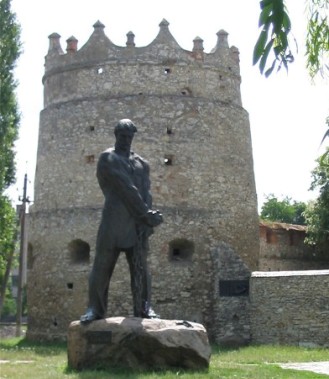
by Ukrainian folk hero Ustym Karmaliuk (a Robin Hood-like figure). He
was captured and buried in Letychiv in 1835; a monument to him now
stands near the fortress tower.
The town grew as a commercial center
with a large Jewish community (about 60% of the population by the late
19th century, or roughly 4,100 people in 1897). Pogroms occurred
sporadically (1882, during the 1917–1921 revolutionary period). During
World War I and the Ukrainian Revolution/Civil War, it changed hands
multiple times and suffered occupations.
World War II Atrocities
(1941–1944)
The fortress's darkest chapter came during the Nazi
occupation. German forces captured Letychiv on 17 July 1941 after heavy
fighting (Soviet defenders blew a river dam to delay the advance). A
Jewish ghetto was established, and a notorious slave labor camp operated
inside the castle ruins under Organisation Todt. Prisoners (primarily
Jews from the region, plus Soviet POWs) were forced to build roads and
infrastructure.
Mass executions followed: approximately 7,200–7,500
Jews were murdered in late 1942 (e.g., 3,000 in September, 4,000 in
November) and additional killings in 1943, many shot in a ravine near
the suburb of Zaletychivka. The town was liberated by the Soviet Second
Ukrainian Front on 23 March 1944. Memorials today mark the sites of
these atrocities, including a plaque on the surviving tower.
Current State and Legacy
After the war, the fortress fell into ruin,
though Soviet plans to demolish the tower were abandoned. The surviving
north-western tower and wall sections (with embrasures still visible)
stand prominently along the Vinnytsia–Khmelnytskyi highway, integrated
with the restored Dominican complex, which functions today as the active
Sanctuary of Our Lady of Letychiv—a Catholic pilgrimage site. A statue
of Ustym Karmaliuk (erected 1974) and other memorials (including to
Holodomor victims) are located nearby.
The site originated as a wooden Lithuanian castle built around 1362
by the Koriatovych princes on elevated terrain along the Vovk River (a
tributary of the Southern Bug). This early structure featured earthen
ramparts and a water-filled moat. In the late 16th century (construction
initiated around 1579 and largely completed by 1598), Polish magnate Jan
Potocki (starosta of Kamianets-Podilskyi) rebuilt it entirely in stone
at the order of the Polish crown. The upgrade transformed a vulnerable
wooden-earth fort into one of Podolia’s strongest outposts, leveraging
local hydrology for enhanced defense. The fortress endured repeated
Tatar and Ottoman assaults in the 15th–17th centuries and later
conflicts, including the Cossack-Polish War. By the 19th century, much
of it was dismantled (final remnants removed around 1865), though parts
were incorporated into a Dominican monastery complex established on the
grounds from 1606.
Overall Layout and Plan
The fortress
followed a classic rectangular enceinte (enclosing) plan typical of
early modern Polish-Lithuanian border fortifications. It enclosed a
large inner courtyard suitable for garrison housing, storage, and
limited civilian refuge. The perimeter consisted of high curtain walls
reinforced at the corners by four round towers for flanking fire and a
quadrangular (rectangular) gate tower oriented toward the open field
(vulnerable southern approach). The town-facing side was protected by an
outer earthen rampart topped with a wooden palisade, creating a layered
defense.
A deep moat, flooded by diverting water from the Vovk River
(and supplemented by two dammed ponds and a dam on the Southern Bug),
separated the stone walls from the rampart. This “wet” moat system
turned the fortress into a semi-aquatic stronghold, slowing attackers,
undermining siege engines, and complicating mining operations—features
vividly depicted on 17th-century maps by French military engineer
Guillaume le Vasseur de Beauplan (showing the fortress amid ponds, dams,
and river barriers) and Zygmunt Gerstmann.
Materials and
Construction Techniques
Primary material was locally quarried
limestone (ashlar facing over rubble core, bonded with lime mortar),
providing durability against artillery and the region’s climate. Walls
reached approximately 2 meters thick and 8–10 meters high, prioritizing
functional mass over ornamentation. Lower levels of towers and walls
incorporated vaulted (barrel or groin) ceilings for structural strength
and fire resistance. Construction reflected pragmatic Renaissance
military engineering: minimal decorative elements, emphasis on height,
embrasures for both archery and early firearms/cannons, and integration
with terrain (elevated Podolian Upland for surveillance).
Defensive Features
Curtain Walls: Pierced with embrasures (loopholes)
and arrow slits for defensive fire. Upper sections originally featured a
covered wooden defensive gallery (on brackets) for protected shooting
positions; remnants of this gallery survive on some wall fragments. The
walls formed a continuous perimeter with a flat, imposing limestone
surface.
Towers: Four round corner towers enabled enfilading (cross)
fire. The surviving north-eastern (sometimes described as north-western)
tower is the most complete example: a two-tiered (plus deep basements)
round structure in plan, with a pronounced batter (slight outward slope
at the base) for stability and deflection of projectiles. Keyhole-shaped
loopholes—wide at the top for sighting, narrowing downward for
protection—were oriented toward the field side, allowing both musket and
cannon fire. Lower chambers have vaulted ceilings; the top features a
stone crenellated parapet (merlons and crenels) and a restored
conical/tented roof on original corbel supports.
Gate Tower:
Quadrangular entrance structure with a drawbridge over the moat (now
gone).
Layered Outer Defenses: Earthen rampart + palisade (inland
side) and the water moat created multiple kill zones. The riverine
setting allowed flooding of approaches, making it exceptionally
difficult for mounted raiders.
Surviving Structures and Current
State
Only fragments remain today, designated an Immovable Monument
of National Significance (reference no. 220039/2). The most prominent is
the fully preserved round north-eastern tower (visible from the
Vinnytsia–Khmelnytskyi highway), now topped with a new roof after minor
restoration. It retains original keyhole loopholes, vaulted basements,
and battlements. Adjacent are sections of the eastern wall and partial
southern wall (not to full original height), with some preserved upper
gallery elements and a modern wooden access walkway for visitors. These
limestone ruins integrate with the neighboring Baroque Assumption Church
and Dominican monastery complex (built 1606–1638, rebuilt 1724), which
repurposed parts of the fortress. Pedestrian paths wind through the
site, offering views of the riverine landscape.
Architectural
Significance
Letychiv Fortress represents a transitional style
between medieval castle architecture and early bastion-trace designs,
optimized for gunpowder-era threats on the Polish-Lithuanian frontier.
Its strength lay not in ornate detail but in integrated hydrology,
geometric regularity, and multi-layered obstacles—making it one of
Podolia’s premier defenses in its era. Though largely ruined, the
surviving tower and walls provide a tangible link to 16th-century
military engineering and continue to serve as a cultural landmark.