Location: Scotland Map
Open: 10am - 6pm
(Last Admission 5pm)
13 Mar- 15 Nov daily
Eilean Donan Castle, perched on a rocky islet at the confluence of Lochs Duich, Long, and Alsh in the Western Highlands of Scotland, is one of the most iconic and photographed castles in the world. Its dramatic setting, surrounded by water and framed by the rugged peaks of Kintail, embodies the romance of Highland history. Built in the early 13th century as a defensive stronghold, it has witnessed Viking raids, clan feuds, Jacobite rebellions, and a 20th-century rebirth, evolving from a fortress to a symbol of Scottish heritage. Managed by the Conchra Charitable Trust, Eilean Donan blends medieval grit with modern allure, drawing over 500,000 visitors annually for its history, architecture, and cinematic fame in films like Highlander and The World Is Not Enough.
Eilean Donan’s story begins around 1220, when a fortified enclosure
was likely built on the islet, named after St. Donnán, a 7th-century
Irish missionary martyred on nearby Eigg. The castle’s founder is
uncertain, but tradition credits Alexander II or a local chieftain,
possibly of Clan Matheson or Mackenzie, seeking to guard the sea lochs
against Norse raiders from Skye. Its name, Eilean Donnain (Gaelic for
“Island of Donnán”), reflects early Christian ties.
By the late
13th century, during the Wars of Scottish Independence, the castle fell
under Clan Mackenzie, who held it as a stronghold of Kintail. Robert the
Bruce reportedly sheltered there in 1306, fleeing English pursuit. The
Mackenzies fortified the site, building a stone keep to control maritime
routes and assert dominance over rival MacRaes and MacDonalds. In 1362,
a dispute over fishing rights led to a Mackenzie-led massacre of
MacDonalds, cementing Eilean Donan’s role in clan rivalries.
The castle’s defenses evolved through the medieval period, with a
curtain wall and tower house added by the Mackenzies. In 1504, James IV
granted the Mackenzies formal control, elevating their status as Earls
of Seaforth. Eilean Donan served as a base during feuds with the
MacLeods of Skye and MacDonalds of Glengarry, its islet position
thwarting land-based assaults.
In 1539, Donald Gorm MacDonald of
Sleat besieged the castle, seeking to reclaim Kintail. The defenders,
led by Duncan MacRae, held firm, with legend claiming Duncan’s arrow
felled Donald, ending the attack. This victory birthed the MacRaes’ role
as the Mackenzies’ hereditary constables, earning them the nickname
“Mackenzie’s Shirt of Mail.” By the 17th century, the castle housed a
small garrison, with a hornwork (triangular earthwork) added to counter
artillery, reflecting evolving warfare.
Eilean Donan’s most dramatic chapter came during the Jacobite
Rebellions. In 1715, the Mackenzies, staunch Jacobites, used the castle
to support James Francis Edward Stuart, the Old Pretender. Government
forces briefly seized it, but the Mackenzies regained control. The
pivotal moment arrived in 1719 during the Battle of Glenshiel, a
Spanish-backed Jacobite uprising. Eilean Donan was garrisoned by 46
Spanish troops, sent to aid the cause, with MacRaes and Mackenzies
coordinating from Kintail.
The British Navy, alerted to the plot,
dispatched three frigates—HMS Worcester, Flamborough, and Enterprise—to
Loch Alsh. On May 10, 1719, they bombarded Eilean Donan, capturing it
after three days. Finding 343 barrels of gunpowder, the Navy demolished
the castle with controlled explosions, reducing it to rubble to prevent
reuse. The Jacobite defeat at Glenshiel weeks later ended the rising,
and Eilean Donan lay in ruins for nearly two centuries, its stones
scattered across the islet.
In 1912, Lt. Col. John MacRae-Gilstrap, a MacRae descendant,
purchased the derelict islet, inspired to restore Eilean Donan as a
family seat and cultural monument. Working with architect George Mackie
Watson and master mason Farquhar MacRae, he began reconstruction in
1913, using surviving foundations and 1719 sketches by military surveyor
Lewis Petit. The project, delayed by World War I, spanned 1913–1932,
costing £250,000 (about £20 million today). MacRae-Gilstrap aimed for
authenticity, blending 13th-century defensiveness with Edwardian
comfort, adding modern plumbing and electricity.
Reopened in
1932, the castle became a Mackenzie and MacRae shrine, housing clan
relics like swords and portraits. The Conchra Charitable Trust, formed
by the MacRaes, manages it today, balancing preservation with tourism.
Eilean Donan’s cinematic roles—Highlander (1986) as the MacLeod
stronghold, Elizabeth: The Golden Age (2007), Made of Honor (2008), and
James Bond’s The World Is Not Enough (1999) as MI6’s Scottish base—have
made it a global icon. As of April 11, 2025, it remains a private trust
property, open to visitors and hosting weddings, with ongoing
maintenance to combat coastal weathering.
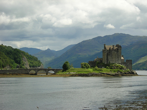
Eilean Donan is a courtyard castle, its compact design maximizing its islet’s 0.4-hectare (1-acre) footprint. Rebuilt on medieval foundations, it evokes a 13th-century fortress while incorporating 20th-century refinements. Constructed of local grey gneiss and sandstone, its walls rise sheer from the loch, linked to the mainland by a stone causeway.
The keep, dominating the southeast corner, is the castle’s heart:
A four-story tower house, roughly 15 x 12 meters, with 3-meter-thick
walls, houses the principal rooms. The ground floor, originally storage,
now displays clan artifacts, including a 1719 cannonball from the
bombardment.
The Banqueting Hall, on the first floor, spans 14 x 7
meters, with a vaulted ceiling, oak beams, and a massive fireplace
inscribed with the Mackenzie motto, Luceo Non Uro (“I shine, not burn”).
Tartan rugs and antler chandeliers add warmth, evoking clan gatherings.
Upper floors include private chambers, with the Billeting Room
showcasing exposed stone and a smaller hearth, used for officers in
1719. A spiral stair leads to battlements, offering 360-degree views of
Loch Duich’s mountains.
A corner turret, topped with a conical roof,
holds a tiny “Crow’s Nest” room, possibly a lookout or chapel.
Courtyard and Enclosure
The courtyard, enclosed by high curtain
walls, is small but functional:
A well, now capped, supplied water,
vital during sieges. Adjacent vaults stored grain, ale, and gunpowder,
with one cellar housing a replica 18th-century kitchen.
The north
range, a low block, contains guest rooms and a modern exhibition space,
with panels on the castle’s history and reconstruction. Its flat roof
doubles as a viewing platform.
The west wall, facing Loch Alsh,
features arrow slits and a postern gate, originally for boat access. A
reconstructed hornwork, based on 1719 plans, juts out, designed to
deflect cannon fire.
The causeway, a three-arched stone bridge built in 1932, replaces
earlier wooden drawbridges, linking the islet to Kintail’s shore. A
vaulted gatehouse, flanked by mock bartizans, guards the entrance, with
a portcullis slot (decorative today) and a Mackenzie crest above. The
bridge’s curve, framed by seaweed-draped rocks, creates Eilean Donan’s
postcard-perfect silhouette.
Reconstruction Details
While the
1932 rebuild used authentic materials, it prioritizes romance over
precision. The keep’s large windows and polished interiors reflect
Edwardian tastes, unlike the cramped, smoky originals. Surviving
fragments—like the south wall’s base and well—anchor the design, but
modern additions, like electric lighting disguised as candles, ensure
comfort. The castle’s small size (covering just 1,500 square meters)
enhances its intimacy, contrasting sprawling fortresses like Stirling.
Eilean Donan’s setting is its greatest asset:
Islet and Lochs: The
castle occupies most of its tidal islet, with waves lapping its walls at
high tide. Lochs Duich, Long, and Alsh converge, their fjord-like depths
reflecting Skye’s Cuillin Hills and Kintail’s Five Sisters peaks—Sgurr
Fhuaran (1,067 meters/3,501 feet) prominent.
Shoreline: The mainland
shore, 50 meters away, hosts a visitor center, car park, and ticket
office, keeping the islet uncluttered. A shingle beach offers photo
spots, with otters and herons often spotted.
Landscape: Beyond the
lochs, heather moorlands and pine forests stretch to Glen Shiel, a
National Scenic Area. The absence of formal gardens suits the castle’s
wild aesthetic, with gorse and rowan dotting the shore.
Views: From
the battlements, visitors see the Skye Bridge (5 miles west) and Loch
Alsh’s islands, with sunsets painting the water gold. The Kintail
mountains, snow-capped into May, frame every angle.
The grounds
are compact, encouraging exploration of nearby Dornie village (0.5 miles
east), with its pubs and clan museum, or hikes to Glenfinnan (25 miles
northeast), site of Bonnie Prince Charlie’s 1745 standard-raising.
Eilean Donan embodies Highland identity and global fascination:
Clan Symbol: As a Mackenzie and MacRae stronghold, it houses relics like
the 1719 Spanish flag and Duncan MacRae’s bow, fostering clan pride.
Annual gatherings, hosted by the trust, draw descendants worldwide.
Jacobite Mythos: The 1719 destruction ties Eilean Donan to Jacobite
defiance, romanticized in tales of Spanish soldiers and daring escapes.
It evokes the Highlands’ lost causes, echoed in nearby Glenfinnan’s
monument.
Cinematic Star: Its film roles amplify its mystique.
Highlander cast it as Connor MacLeod’s ancestral home, blending myth
with scenery, while The World Is Not Enough used its bridge for Bond’s
Q-Boat chase. Indian films like Kuch Kuch Hota Hai (1998) made it a
Bollywood staple, boosting Asian tourism.
Romantic Ideal: The 1932
rebuild, driven by MacRae-Gilstrap’s vision, reflects 20th-century
nostalgia for a “noble” Highlands, post-Clearances. Its fairy-tale
aesthetic inspires weddings, with 100+ ceremonies yearly in the
Banqueting Hall.
Community Hub: Dornie relies on castle tourism, with
local shops selling tartan and whisky. The Eilean Donan Pipe Band,
formed 1998, performs at openings, tying the castle to living culture.
The castle bridges past and present, its stones whispering of
warriors, its films shouting to millions. It embodies Scotland’s knack
for turning hardship into heritage.
Visiting Eilean Donan Today
Located off the A87 near Dornie, 8 miles east of Kyle of Lochalsh,
Eilean Donan is a 3-hour drive from Glasgow (130 miles) or 2 hours from
Inverness (70 miles). The nearest train station, Kyle of Lochalsh, links
to Inverness (2.5 hours), with buses (917, 915) stopping at Dornie’s
bridge. Free parking accommodates 200 cars, with EV chargers available.
Opening hours (2025):
March 1–October 31: Daily, 10:00 AM–6:00 PM
(last entry 5:00 PM).
November 1–December 23: Daily, 10:00 AM–4:00 PM
(last entry 3:00 PM).
Closed December 24–February 28, except for
pre-booked events.
Admission costs £12 for adults, £7 for
children (5–15), £10 for concessions, and £30 for families (2 adults, 3
children), with free entry for under-5s and Conchra Trust members.
Guided tours, included in the ticket, run every 30 minutes, covering
clan history and film trivia (45 minutes). Self-guided visits are also
available, with multilingual audio guides (£3).
The castle is
moderately accessible:
The causeway and courtyard suit wheelchairs,
but the keep’s spiral stairs (60 steps to the Banqueting Hall) limit
upper access. A virtual tour tablet aids those unable to climb.
Cobbled paths and uneven floors require sturdy shoes. Children enjoy
exploring nooks, but parents should mind low ceilings and drops.
Dogs
are allowed on the grounds (leashed, not indoors).
Highlights
include:
Banqueting Hall: Admire its hearth and clan portraits,
staged for a Mackenzie feast.
Exhibition Room: View 1719 artifacts,
reconstruction photos, and a Highlander sword replica.
Battlements:
Snap Loch Alsh vistas, with Skye’s outline on clear days.
Visitor
Centre: A café serves Cullen skink and shortbread, while the shop stocks
whisky and tartan scarves.
Nearby attractions include the Skye
Bridge, Plockton’s coral beach (10 miles), and Glenelg’s Pictish brochs
(20 miles). Dornie’s Loch Long Hotel offers Outlander-themed stays,
complementing a castle visit.
Eilean Donan faces ongoing preservation demands:
Weathering:
Lochside exposure erodes mortar, with 2024 storms damaging the
causeway’s arches. Annual repointing costs £50,000, funded by ticket
sales and donations.
Tourism Strain: Half a million visitors yearly
wear paths and crowd Dornie’s roads, prompting timed entries and shuttle
buses from Kyle.
Climate Risks: Rising sea levels threaten the islet,
with flood barriers planned by 2030. Warmer winters reduce Skye’s snow
backdrop, subtly altering its aesthetic.
Authenticity Debate: Critics
note the 1932 rebuild’s polished interiors deviate from medieval
starkness, though defenders argue it captures the castle’s spirit.
The Conchra Trust invests in sustainability, adding solar panels
(2023) and promoting eco-tourism, like e-bike rentals. Community input
ensures Dornie benefits, with locals staffing 80% of roles.
Eilean Donan is more than a castle; it’s a Highland saga in stone. Its walls withstood Vikings and cannons, its ruins rose from ashes, and its image graces calendars worldwide. From Mackenzie lairds to Jacobite dreams, it carries Lochaber’s soul—fierce, enduring, and hauntingly beautiful. As a clan haven, film star, and wedding stage, it weaves history with fantasy, inviting all to cross its bridge.