Hadrian's Wall is an ancient Roman series of defenses that run across the United Kingdom.
Location: the wall roughly runs along highways A69 and B6318 Map
Constructed: started in AD 122 by emperor Hadrian
The Wall or Hadrian's Wall is an old defensive construction of
the island of Britania , built between 122 - 132 by order of the
Roman emperor Hadrian to defend the British territory submitted,
south of the wall, to the warlike tribes of the Picts which extended
further north of the wall, in what would later become Scotland after
the invasion of the shafts from Ireland . The wall also had the
function of maintaining economic stability and creating peace
conditions in the Roman province of Britanniasouth of the wall, as
well as physically marking the border of the Roman Empire . Today
important sections of the wall still remain, while other sections
have disappeared as their stones have been reused in neighboring
buildings for centuries.
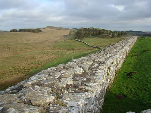
This fortified limes extended for 117 km from the Gulf of Solway in
the west to the estuary of the Tyne River in the east, between the
towns of Pons Aelius (now Newcastle upon Tyne ) and Maglona ( Wigton
). 1The wall itself was built entirely with stone blocks, it was 2.4
to 3 meters thick and 3.6 to 4.8 meters high. It had 14 main forts
and 80 forts that housed garrisons at key surveillance points, as
well as a pit in its northern part of 10 m and a military road that
ran along its southern side. Further south of the military road they
built another moat with two earth embankments to protect the wall
from attacks from the south. Its name is sometimes used as a synonym
for the border between Scotland and England , although the wall
follows a line farther south than the modern border.
Its defensive function was subsequently assumed by the wall of
Antonino Pio , raised further north and abandoned after a brief
period before the hostility of the Caledonian tribes, making the
wall of Hadrian again the northern limit of the Roman territory of
Britain. The Picts crossed the wall three times, in 197 , 296 and
367 . It was repaired and enlarged in 209 , during the reign of
Septimius Severus , and finally abandoned in 383 . After their
abandonment, the inhabitants of the region reused many stones from
the wall to build farms, churches and other buildings.
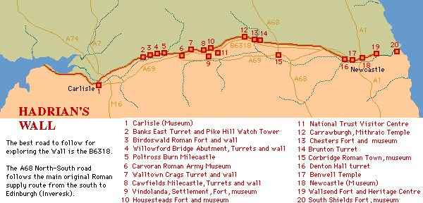
Hadrian's Wall was constructed started in AD 122 by emperor Hadrian to defend south part of the island known at the time as a Roman province of Britannia against attacks by barbarian tribes from the North. The wall roughly runs along highways A69 and B6318. There over 16 large forts along its length, along with 80 smaller fortifications and 158 turrets to keep an eye over dangerous frontier.
Chesters Fort (Cilurvum or Cilurnum)
Location: Map
Cilurvum or Cilurnum is one of the best preserved forts along a Hadrian's Wall that was mentioned in Notitia Dignitatum, documentation of Roman imperial chanceries. It is located near a town of Chester also known as Walwick Chesters in the Northumberland County of United Kingdom. It was constructed in 123 AD as a cavalry fort intended to strengthen presence in the region. It was known as ala Augusta ob virtutem appellata ("named Augusta because of its valour"). Any attack from a North would result in retaliation attacks from a Roman cavalry deep into enemy territory. Later contingent was strengthened by infantry units of First Cohor of Vangiones from the Upper Rhineland in German province and First Cohor of Dalmations from present day Serbia, Croatia, Bosnia and Herzegovina. Among old barracks you find an altar of a "Cult of Disciplina", that was actively encouraged by the emperor Hadrian himself. Archeological digs continue for decades and still there is a lot of work to be done. Numerous findings from a site are presented in the museum of the site.
Hadrian's Wall, one of the most impressive remnants of the Roman
Empire in Britain, stretches across northern England from the River Tyne
in the east to the Solway Firth in the west. Built in the early 2nd
century AD, this 73-mile (117 km) fortification served as the
northwestern frontier of Roman Britannia for nearly three centuries,
symbolizing imperial power and control. Comprising a stone or turf wall,
ditches, forts, milecastles, and turrets, it was designed to defend
against northern tribes while facilitating trade and taxation. Today,
managed by organizations like English Heritage and the National Trust,
it is a UNESCO World Heritage Site attracting over a million visitors
annually, offering insights into Roman engineering, military life, and
frontier dynamics.
Origins and Foundation (Early 2nd Century AD)
The wall's origins trace to the reign of Emperor Hadrian (AD 117–138),
whose family hailed from Spain but who was raised in Rome. Hadrian's
policies emphasized consolidation over expansion, influenced by unrest
across the empire, including in Britain where Roman control was tenuous
north of the Tyne-Solway isthmus. Planning likely began before Hadrian's
visit to Britain in AD 122, building on existing military infrastructure
like the Stanegate road and forts from Agricola's campaigns in the late
1st century. During his tour, Hadrian ordered construction to "separate
the Romans from the barbarians," as recorded in his biography. The site
was chosen slightly north of the Stanegate, leveraging natural features
like rivers and crags for defense.
Construction (AD 122–128)
Work commenced in AD 122, involving three legions—II Augusta, VI
Victrix, and XX Valeria Victrix—totaling about 15,000 men, supported by
auxiliaries and the British fleet. Inscriptions, such as those with the
20th Legion's boar emblem, confirm their roles. The project took at
least six years, with sections surveyed from east to west.
Initially,
the design included a stone wall in the east (10 Roman feet/3 meters
wide, up to 15 feet/4.6 meters high) and turf in the west (20 Roman
feet/6 meters wide). A deep ditch fronted the wall, with milecastles
every mile for gates and turrets every third of a mile for observation.
Mid-construction changes added 14 forts along the wall (spaced 7⅓ miles
apart) and the Vallum—a 120 Roman feet (35 meters) wide earthwork with a
central ditch south of the wall for rear protection. The wall's width
narrowed to 8 Roman feet (2.4 meters) in places to expedite completion.
Turf sections were later replaced with stone under Hadrian and after the
Antonine Wall's abandonment. Archaeological evidence, like offsets in
foundations, reveals these phases.
Purpose and Military Role
The wall's primary purpose was defensive, slowing invaders and
channeling movement through controlled gates for surveillance, taxation,
and intelligence. It symbolized Roman authority, possibly whitewashed
for visibility, and marked the empire's limit without full northern
conquest. Theories include influences from other frontiers like the
Limes Germanicus, though not a direct copy. Garrisoned by 10,000
auxiliaries from across the empire (e.g., Batavians, Tungrians), forts
housed 500–1,000 troops each, focusing on patrols and border control
rather than constant warfare.
Life Along the Wall
Military
life involved auxiliaries in barracks, with Vindolanda tablets revealing
daily routines, supply chains, and multicultural garrisons. Civilian
settlements (vici) grew outside forts by the 3rd century, housing
families, traders, and artisans, turning areas like Corbridge into
vibrant towns. Initially, the Vallum restricted civilian access, but
this relaxed over time. Artifacts like the Staffordshire Moorlands Pan
(AD 2nd century) list forts and confirm the wall's name, Vallum Aelii.
Modifications and Later Roman Period (AD 138–410)
After Hadrian's
death, Antoninus Pius (r. 138–161) abandoned the wall in favor of the
Antonine Wall farther north (built AD 142 of turf), which lasted about
20 years before reoccupation of Hadrian's Wall around AD 164 under
Marcus Aurelius. A major invasion around AD 180 prompted repairs, turret
abandonments, and redeployments. Under Septimius Severus (AD 208–211),
reinforcements occurred during Caledonian campaigns. By the 3rd century,
milecastle gates were narrowed, and cavalry units concentrated at key
points. Forts were modified with new barracks and headquarters,
persisting until Roman withdrawal around AD 410, with latest coins dated
AD 403–406.
Abandonment and Post-Roman History (5th Century
Onward)
As Roman authority waned, the wall was abandoned by AD 410,
though some forts like Birdoswald may have seen continued local use into
the 5th century as chieftain strongholds. In medieval times, stones were
quarried for castles, churches, and farms. Interest revived in the
18th–19th centuries; antiquarians like John Clayton (who acquired and
excavated sites from 1843) and John Collingwood Bruce preserved
sections. Excavations from the mid-19th century onward, including recent
finds like a 3-meter section in Newcastle (2021), have enhanced
understanding.
Current Status
Designated a UNESCO World
Heritage Site in 1987 (expanded in 2005 as part of the Frontiers of the
Roman Empire), the wall is protected as a Scheduled Monument. Managed by
English Heritage, the National Trust, and others, sites like
Housesteads, Vindolanda, and Chesters feature museums and
reconstructions. The Hadrian's Wall Path National Trail draws hikers,
while preservation includes erosion repairs using local stone.
Culturally, it inspires films (The Eagle, King Arthur), literature, and
games (Assassin's Creed Valhalla).
Hadrian's Wall, also known as the Picts' Wall, is a monumental
Roman fortification constructed beginning in AD 122 during the reign
of Emperor Hadrian. Stretching approximately 73 miles (117
kilometers) from Wallsend on the River Tyne in the east to
Bowness-on-Solway on the Solway Firth in the west, it marked the
northern frontier of the Roman Empire in Britannia. The wall was
designed not only as a defensive barrier against northern tribes but
also potentially for controlling movement, customs, and signaling.
Built by the Roman legions over about six years, it incorporated a
complex system of walls, ditches, forts, milecastles, and turrets,
reflecting advanced Roman engineering. After abandonment around AD
410, much of the wall was dismantled for local building materials,
but significant ruins remain, now a UNESCO World Heritage Site
managed by organizations like English Heritage and the National
Trust.
Overall Layout and Site Planning
The wall's layout
was meticulously planned to exploit the natural topography of
northern England, following ridges and crags where possible for
enhanced visibility and defense, such as along the Whin Sill
escarpment in the central section. It divided into eastern and
western sectors: the eastern part from the Tyne to the River Irthing
was built in stone, while the western section was initially turf and
timber, later replaced with stone. The core element was the curtain
wall, fronted to the north by a wide V-shaped ditch (up to 8.2
meters/27 feet wide and 3 meters/10 feet deep) and a berm (flat
strip) of 6 meters (20 feet) separating them. To the south, about
45-90 meters (150-300 feet) behind the wall, ran the Vallum—a
massive earthwork consisting of a central ditch (6 meters/20 feet
wide, 3 meters/10 feet deep) flanked by two parallel mounds (each 6
meters/20 feet wide at the base, 2 meters/6.5 feet high), creating a
controlled zone possibly for customs or to prevent smuggling.
The
system included 80 milecastles (small fortlets) spaced every Roman
mile (about 1.48 kilometers/0.92 miles), each with gateways for
controlled passage. Between milecastles were two turrets for
observation, resulting in surveillance points every third of a mile.
Initially, the plan lacked large forts, but around AD 124-128, 16-17
forts were added along or astride the wall, housing garrisons of
500-1,000 soldiers each. Coastal extensions added milefortlets and
towers westward to Maryport and eastward to South Shields, extending
the defensive line to about 120 miles total. A military road (the
Stanegate) predated the wall south of it, later supplemented by
another road behind the Vallum for logistics.
The Curtain
Wall: Core Defensive Structure
The wall itself varied in
construction: in the east, it was built on a "broad" foundation of 3
meters (10 feet) wide, narrowing to about 2.4 meters (8 feet) at the
top, with an estimated original height of 4.6-6 meters (15-20 feet)
including a parapet walkway (though evidence for a continuous
walkway is debated; some sections may have had timber breastworks).
The western turf wall was initially 6 meters (20 feet) wide at the
base, tapering to 2.4 meters (8 feet) at the top, about 3.5 meters
(11.5 feet) high, with a timber palisade. By the AD 160s, the turf
was replaced with stone to match the east.
The stone wall
featured a rubble core of local stones bound with lime mortar, faced
with neatly dressed squared stones (ashlar) on both sides, often
with lifting lewis holes visible for construction. The facing stones
were typically 20-25 cm (8-10 inches) square, laid in regular
courses. Where the wall crossed rivers, like at Willowford, stone
bridges were built, with abutments and piers surviving. No mortar
was used in some joints, relying on precise fitting, and the wall's
alignment was straight between high points, with slight deviations
for terrain.
Milecastles, Turrets, and Forts
Milecastles
were rectangular fortlets, typically 15-20 meters (50-65 feet) by
18-23 meters (60-75 feet), with thick walls (up to 2.4 meters/8
feet), internal barracks for 8-32 soldiers, ovens, and gateways. The
north gate was often a single portal with pivoting doors and a tower
above, while the south gate was similar but sometimes blocked later.
Designs varied by legion: short-axis (gates on short walls) or
long-axis types, with some having ascending ramps to the wall.
Turrets, spaced at intervals of about 500 meters (third of a mile),
were square towers 4-6 meters (13-20 feet) on each side, projecting
northward, with recessed walls tying into the main curtain. They
featured a ground-floor platform, possibly for signaling or archery,
and upper levels accessed by ladders.
Forts, added later, were
larger playing-card shaped enclosures (e.g., Housesteads at 2.3
hectares/5.7 acres), straddling the wall with three gates north and
three south. They included principia (headquarters), praetorium
(commander's house), barracks, hospitals, granaries, and workshops,
built in stone with hypocaust heating and latrines. Some forts, like
Vindolanda south of the wall, predate it and were integrated into
the system.
Architectural Styles and Evolution
Hadrian's
Wall embodies Roman military architecture, blending utilitarian
design with engineering prowess. Initial construction under Governor
Aulus Platorius Nepos followed standardized Roman frontier models,
similar to the German limes but more substantial. The shift from
turf to stone in the west reflects adaptations, possibly due to
resource availability or strategic reevaluation. By the reign of
Antoninus Pius (AD 138-161), the wall was briefly superseded by the
Antonine Wall further north, leading to temporary abandonment and
repairs upon reoccupation around AD 158. Later modifications
included blocking some milecastle gates, adding causeways over the
ditch, and constructing temples or victory monuments. The Vallum's
crossings were narrowed to control access, evolving from a boundary
to a managed zone.
Materials and Construction Techniques
Local materials dominated: sandstone and limestone quarried nearby
(e.g., from the Whin Sill), with turf and timber in the west.
Legionaries (about 15,000 men from Legions II Augusta, VI Victrix,
and XX Valeria Victrix) built it, divided into sections with
centurial stones marking work gangs. Techniques included digging
foundations (0.3-0.6 meters/1-2 feet deep), layering rubble with hot
lime mortar, and facing with hammered stones. Cranes and lewis irons
lifted blocks, while ramps aided turf stacking. The ditch was cut
with V-profile for defensibility, and the Vallum's mounds were
revetted with turf. Construction proceeded from east to west, with
milecastles and turrets built first as bases, then the wall
connected them.
Notable Features and Historical Modifications
Key features include the Sycamore Gap (a dramatic dip with a famous
tree, felled in 2023), bridge remains at Chesters and Willowford,
and the Mithraeum temple at Carrawburgh. Modifications post-Hadrian
included fort additions, possibly ordered by Hadrian himself upon
review. In the 3rd-4th centuries, repairs used coarser stonework,
and some turrets were dismantled. The wall saw action during
incursions, like in AD 197, requiring rebuilding. After Roman
withdrawal, it became a quarry, with stones reused in medieval
buildings like Lanercost Priory.
Current State as Ruins
Today, about 10% of the wall survives above ground, with the central
section (e.g., between Steel Rigg and Housesteads) best preserved,
standing up to 3 meters (10 feet) high in places. Excavated sites
like Vindolanda reveal wooden tablets with daily life details. The
wall is a popular walking path (Hadrian's Wall Path, 84 miles), with
museums at Segedunum, Chesters, and Vindolanda displaying artifacts.
Conservation efforts combat erosion, and it's part of the Frontiers
of the Roman Empire World Heritage Site, attracting visitors for its
historical and scenic value.