Location: Wales
Area: 934 sq mi (2,419 sq km)
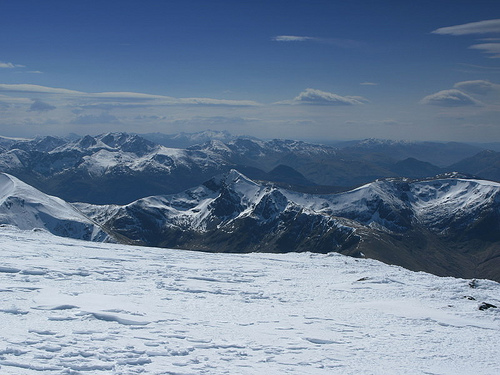
The Lochaber Mountains, located in the West Highlands of Scotland, form a dramatic and rugged region within the broader Grampian Mountains, renowned for their towering peaks, deep glens, and rich geological and cultural significance. Centered around the district of Lochaber, which spans parts of Highland and Argyll, this area includes some of Britain’s highest summits, notably Ben Nevis, and is a magnet for mountaineers, geologists, and nature enthusiasts. Its landscapes, shaped by ancient tectonic forces, glaciation, and human history, tell a story of natural grandeur and resilience.
The Lochaber Mountains lie in western Scotland, roughly bounded by
the Great Glen to the north, Glen Spean to the east, Loch Linnhe to the
southwest, and the Glen Coe area to the south. The region, part of the
Lochaber district, centers on Fort William, dubbed the “Outdoor Capital
of the UK.” It encompasses iconic peaks like Ben Nevis (1,345
meters/4,413 feet), Britain’s highest mountain, and the Mamores, Grey
Corries, and Aonach Mor ranges, forming a compact but varied highland
massif.
The area spans approximately 2,000 square kilometers (770
square miles), though definitions vary, as Lochaber’s cultural
boundaries extend beyond strict geological limits. Key valleys—Glen
Nevis, Glen Roy, and Glen Spean—carve through the mountains, while lochs
like Loch Laggan and Loch Lochy add shimmering counterpoints to the
rugged terrain. The region’s proximity to the Atlantic, with Loch
Linnhe’s fjord-like waters, shapes its climate and accessibility.
The Lochaber Mountains are a study in contrasts, blending sheer peaks
with gentle plateaus:
Ben Nevis: The undisputed monarch, Ben Nevis
dominates with its massive bulk, rising from sea level at Fort William
to its summit plateau. Its north face, a 700-meter (2,300-foot) cliff,
is a premier climbing arena, riddled with gullies like Tower Ridge and
Observatory Gully. The summit, capped by a cairn and ruined observatory,
offers views to the Hebrides on clear days.
Mamores Range: South of
Ben Nevis, this chain of 10 Munros (peaks over 3,000 feet) includes
Binnein Mor (1,130 meters/3,707 feet) and Stob Ban (999 meters/3,278
feet). Known for sharp ridges and grassy slopes, the Mamores offer
challenging traverses like the Ring of Steall.
Grey Corries: East of
Ben Nevis, these quartzite-capped peaks, such as Stob Choire Claurigh
(1,177 meters/3,862 feet), gleam white in sunlight, their scree slopes
contrasting with darker schists below.
Aonach Mor and Aonach Beag:
Northeast of Ben Nevis, these twins—Aonach Mor (1,221 meters/4,006 feet)
and Aonach Beag (1,234 meters/4,049 feet)—form a high plateau, with
Aonach Mor hosting a ski resort, rare for Scotland.
Glen Coe: While
technically separate, Glen Coe’s peaks, like Buachaille Etive Mor (1,022
meters/3,353 feet), are often included in Lochaber’s orbit due to
proximity and shared geology. Its steep ridges and U-shaped valley are
iconic.
Glens, such as Glen Nevis, cradle rivers like the Water
of Nevis, while corries (glacial cirques) like Coire Leis on Ben Nevis
hold tarns and snowfields, some persisting year-round. The mountains’
elevation, though modest globally, feels dramatic due to their rise from
near sea level, creating a compressed, alpine-like intensity.
The Lochaber Mountains are a geological mosaic, forged over 800
million years:
Caledonian Orogeny: Around 400 million years ago,
tectonic collisions during the formation of the supercontinent Pangaea
thrust up the Grampians, including Lochaber’s core. Metamorphic
rocks—schists, gneisses, and quartzites—dominate, with Ben Nevis’ lower
slopes formed of mica schist and its summit of andesite lava, evidence
of ancient volcanism.
Devonian Volcanism: The Glen Coe area, part of
Lochaber’s southern fringe, hosts a collapsed caldera from a
supervolcano (c. 420 million years ago). Its rhyolite and basalt cliffs,
like those of Buachaille Etive Mor, draw geologists worldwide.
Glaciation: The last Ice Age (ending c. 10,000 BCE) sculpted Lochaber’s
U-shaped glens, hanging valleys, and arêtes. Ben Nevis’ north face bears
glacial striations, while Glen Roy’s “Parallel Roads”—ancient shorelines
of a glacial lake—are a globally unique feature, studied since Charles
Darwin’s 1838 visit.
Mineral Wealth: Quartzite in the Grey Corries
and granite in Glen Nevis supported small-scale quarrying, though
Lochaber’s remoteness limited exploitation compared to Wales or
Cornwall. Lead and zinc traces exist, but commercial mining never
thrived.
This geological diversity underpins the region’s rugged
beauty and climbing challenges, with stable schists favoring technical
routes and loose scree testing endurance.
Lochaber’s ecosystems reflect its altitude and Atlantic exposure:
Flora: Lower slopes host Caledonian pine forests, with Scots pine,
birch, and rowan in Glen Nevis, remnants of ancient woodlands. Heather
and bilberry cloak moorlands, while alpine meadows on high ridges
feature rare Arctic species like purple saxifrage and moss campion. Peat
bogs in Glen Roy store carbon, vital for climate goals.
Fauna: Red
deer roam widely, their numbers managed to prevent overgrazing. Golden
eagles and peregrine falcons soar above corries, with ptarmigan and
mountain hares adapting to summits. Otters and salmon thrive in the
Teith and Lochy rivers, while pine martens, reintroduced, reclaim
forests. Lochaber’s marine fringe supports seals and porpoises in Loch
Linnhe.
Conservation: Nevis Range and Glen Coe lie within National
Scenic Areas, with parts of Glen Nevis in the Ben Nevis Site of Special
Scientific Interest (SSSI). The John Muir Trust and NatureScot protect
habitats, combating invasive rhododendrons and restoring native trees.
Climate change threatens snowfields, with Ben Nevis’ summit snow
shrinking, impacting species like the snow bunting.
Challenges
include balancing tourism—over 150,000 climb Ben Nevis annually—with
erosion control. Paths like the Ben Nevis Mountain Track are maintained,
but scree damage and litter strain resources.
The Lochaber Mountains have shaped human activity for millennia:
Prehistory: Mesolithic hunters roamed post-glacial Lochaber (c. 8000
BCE), leaving flint tools in Glen Roy. Bronze Age cairns and Iron Age
vitrified forts, like Dun Deardail near Fort William, suggest early
settlement, with clans using glens for grazing.
Clan Era: By the
medieval period, Lochaber was a stronghold of Clan Cameron, whose seat
at Achnacarry remains influential. The Camerons clashed with MacDonalds
and Campbells, notably during the 13th-century feuds tied to Lochaber’s
control. Ben Nevis, named possibly from Gaelic Beinn Nibheis (“mountain
of heaven” or “venomous”), held spiritual weight, with pilgrims climbing
it.
Jacobite Rebellions: Lochaber was a Jacobite heartland. In 1745,
Bonnie Prince Charlie raised his standard at Glenfinnan, 20 miles west,
rallying Camerons for the ’45 Rebellion. Fort William, built in 1690 to
pacify clans, was besieged by Jacobites, its cannons now flanking Doune
Castle’s gatehouse. Post-Culloden (1746), Highland culture faced
suppression, with Lochaber’s glens depopulated by clearances.
Industrial Age: The 19th century brought railways and tourism. The West
Highland Line (1894), skirting Lochaber, opened Ben Nevis to Victorian
climbers, while the 1901 Ben Nevis Observatory recorded weather until
1904, its ruins a summit landmark. Aluminium smelting, using Lochaber’s
hydropower, began in 1929 at Kinlochleven, though mining stayed minimal.
Modern Era: Today, Lochaber thrives on outdoor tourism. Fort William
hosts the UCI Mountain Bike World Cup, drawing 20,000 spectators to
Aonach Mor. Climbing festivals and Munro-bagging (climbing all 282
Scottish peaks over 3,000 feet) cement Lochaber’s allure, with 13 Munros
in the Mamores alone. Films like Braveheart and Harry Potter (Glen Coe’s
peaks as Hogwarts’ backdrop) amplify its global image.
Culturally, Lochaber embodies Highland spirit. Gaelic, spoken by 5%
locally, survives in place names—Aonach (ridge), Coire (cirque)—and
music, with ceilidhs in Fort William pubs. The Lochaber Games, featuring
caber tossing, celebrate clan heritage, while Ben Nevis’ annual race
(since 1895) tests runners, the record standing at 1 hour 25 minutes.
Lochaber’s peaks are mountaineering meccas, each with distinct
character:
Ben Nevis: The “Ben” offers two faces: the gentle Mountain
Track (former Pony Track) for hikers, and the north face’s Grade V ice
climbs for experts. Its summit plateau, often cloud-shrouded, holds a
war memorial and trig point.
Mamores: Peaks like Am Bodach (1,032
meters/3,386 feet) feature knife-edge ridges, ideal for scramblers. The
Ring of Steall, linking four Munros, is a 16-kilometer, 10-hour epic.
Grey Corries: Sgurr Choinnich Mor (1,094 meters/3,589 feet) and its
quartzite ridges offer solitude, with views to Ben Nevis’ cliffs.
Aonach Beag: Higher but less visited than Aonach Mor, its remote corries
suit wild campers. Aonach Mor’s gondola, opened 1989, serves skiers and
summer hikers.
Carn Mor Dearg: At 1,220 meters (4,003 feet), its
arête to Ben Nevis is a classic ridge walk, testing nerves with
1,000-meter drops.
Glens like Glen Nevis, with Steall Falls’
120-meter cascade, and Glen Roy, with its Parallel Roads, add lowland
charm, accessible by car or foot.
Lochaber’s maritime climate is wet and changeable, shaped by Atlantic
fronts:
Rainfall: Annual precipitation averages 2,000–3,500 mm, with
Ben Nevis’ summit among Scotland’s wettest spots. Fort William sees 200
rainy days yearly.
Temperature: Summers range 10–20°C (50–68°F),
winters 0–8°C (32–46°F), with summits dropping to -10°C (14°F). Snow
lingers on north faces into June.
Winds: Westerly gales, often 50–100
mph on peaks, pose risks, as do sudden fogs reducing visibility to
meters.
Microclimates: Glen Nevis’ sheltered floor is milder, while
Aonach Mor’s plateau catches fierce blizzards. Fort William, at sea
level, avoids extremes.
Weather shifts rapidly—hikers may face
sun, rain, and sleet in hours. Climate change shortens snow seasons,
impacting skiing, but increases landslide risks from heavier rains.
Human Geography and Access
Lochaber’s population centers on Fort
William (10,000), with smaller villages like Spean Bridge and
Kinlochleven. Roads (A82, A86) and the West Highland Line link to
Glasgow (100 miles south), while ferries from Mallaig connect to Skye.
Trails like the West Highland Way, ending in Fort William, draw 100,000
walkers yearly, with hostels and campsites catering to them.
Access to peaks is open under Scotland’s “right to roam,” but paths
vary:
Ben Nevis Mountain Track: A 17-kilometer round trip from Glen
Nevis, gaining 1,300 meters, takes 6–8 hours. It’s busy but eroded, with
cairns guiding through scree.
Mamores and Grey Corries: Tracks from
Kinlochleven or Spean Bridge lead to ridges, requiring navigation
skills. The Ring of Steall starts at Steall Falls’ wire bridge.
Glen
Coe: The A82 offers carpark access to Buachaille Etive Mor’s ridges,
with shorter hikes to Hidden Valley.
Safety is critical—20 deaths
occur annually on Ben Nevis due to falls or exposure. Lochaber Mountain
Rescue, based in Fort William, responds to 100+ callouts yearly, urging
hikers to carry maps, compasses, and bivvy bags.
Lochaber faces environmental pressures:
Erosion: Footfall on Ben
Nevis’ track dislodges scree, costing £100,000 yearly to repair.
Volunteer groups like Friends of Nevis maintain paths.
Litter:
Tourists leave 4 tons of waste annually on Ben Nevis, prompting
clean-ups by the Nevis Landscape Partnership.
Climate Impact: Warming
reduces Aonach Mor’s ski season, while heavy rains destabilize slopes,
as seen in 2023 Glen Coe landslides.
Overuse: Crowds strain parking
and wildlife, with deer disturbed by campers. Signs urge sticking to
paths to protect flora.
Initiatives include rewilding—planting 2
million trees in Lochaber by 2030—and renewable energy, with hydropower
from Loch Laggan. The Nevis Range’s carbon-neutral goal (2040) balances
tourism with ecology.
The Lochaber Mountains are Scotland’s wild heart, blending raw geology with human endeavor. Ben Nevis challenges climbers, Glen Coe inspires poets, and the Mamores reward solitude-seekers. Their glens cradled clans, their peaks defied empires, and their trails now welcome the world. From Parallel Roads to Harry Potter’s vistas, Lochaber weaves science, history, and myth into a landscape that feels eternal yet alive.