Location: County Fermanagh Map
Tel. 028 6634 8855
Open: end- Mar- June & Sept 10am- 4:30pm daily
July- Aug 10am- 5pm daily
Official site
The Marble Arch Caves, located in County Fermanagh, Northern Ireland, are one of Europe’s finest show caves, renowned for their extensive underground network and stunning geological formations. Named after the nearby Marble Arch, a natural limestone bridge, the caves are part of the Marble Arch Caves Global Geopark, which spans parts of Northern Ireland and the Republic of Ireland. They were first explored in 1895 by French speleologist Édouard-Alfred Martel and have since become a major tourist attraction, offering guided tours that showcase their natural beauty and geological significance.
The caves are formed within Carboniferous limestone,
dating back approximately 340 million years. Over millennia, acidic
rainwater dissolved the soluble limestone, carving out an intricate
system of passages, chambers, and underground rivers. The caves are part
of a larger karst landscape, characterized by sinkholes, disappearing
streams, and springs. The limestone’s high purity gives the caves their
sparkling, marble-like appearance, particularly where calcite deposits
form stalactites, stalagmites, and flowstones.
Key geological
features include:
Stalactites and Stalagmites: These calcite
formations hang from ceilings or rise from floors, created by
mineral-rich water dripping over thousands of years. Some stalactites in
the caves are hollow, forming delicate “soda straws.”
Flowstones:
Smooth, sheet-like calcite deposits resembling frozen waterfalls, often
seen along cave walls.
Columns: Formed when stalactites and
stalagmites meet, some reaching impressive heights.
Helictites: Rare,
twisted formations that defy gravity, growing sideways due to capillary
action.
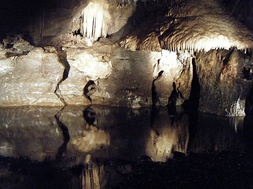
The Marble Arch Caves extend over 11.5 kilometers,
though only about 1.5 kilometers are accessible during public tours. The
show cave tour, lasting around 75 minutes, combines a boat journey with
a walking section, offering a vivid introduction to the underground
world.
Boat Journey: Tours begin with a short boat ride along the
Cladagh River, which flows through the cave system. This subterranean
river, one of the longest known in the UK, originates on Cuilcagh
Mountain and resurges at the Cladagh Glen. The boat glides past
illuminated formations, with low ceilings and dripping water creating an
immersive experience.
Walking Section: After disembarking, visitors
explore chambers like the Grand Gallery, Pool Chamber, and Moses Walk.
The Grand Gallery features towering columns and intricate calcite
curtains, while the Pool Chamber showcases reflective pools framed by
flowstones. The Moses Walk, named for its narrow, water-splashed path,
gives a sense of the cave’s raw, untouched nature.
Lighting and
Accessibility: Artificial lighting highlights key formations, though
some areas retain dimness to preserve the natural ambiance. Pathways are
paved, with handrails for safety, but the tour involves uneven surfaces
and steps, making it less suitable for those with mobility issues.
The Great Stalactite: One of the largest stalactites
in the caves, measuring several meters long, is a highlight of the tour.
Calcite Curtains: Thin, translucent sheets of calcite hang like drapes,
glowing under lights.
Underground Rivers: The Cladagh River’s flow
varies seasonally, sometimes flooding parts of the cave, which can lead
to tour cancellations during heavy rain.
Fossils: The limestone
contains marine fossils, such as corals and shells, offering glimpses
into the ancient tropical sea that once covered the region.
The caves support a unique ecosystem adapted to darkness. While no large animals inhabit the caves, small invertebrates like cave spiders and crustaceans thrive in the damp environment. Bats, including species like the Daubenton’s bat, occasionally roost in quieter sections, though they’re rarely seen on tours. The surrounding Geopark hosts richer biodiversity, with blanket bogs, woodlands, and rare plants like the globeflower.
The caves were likely known to locals for centuries, but systematic exploration began in the late 19th century. Martel and Dublin scientist Lyster Jameson mapped the initial passages in 1895, navigating by candlelight. Further explorations in the 20th century revealed deeper sections, and by 1985, the caves were developed as a show cave with pathways and lighting. The site’s designation as part of a UNESCO Global Geopark in 2001 (expanded in 2004) underscores its international importance.
Tours: Guided tours run from March to October, with
extended hours in summer. Off-season access is limited due to flooding
risks. Tickets cost around £13 for adults, with discounts for children
and families (based on recent data).
Facilities: A visitor center
offers exhibits on cave formation, local wildlife, and Geopark history,
plus a café and gift shop. Nearby walking trails explore the Cuilcagh
Lakelands and Cladagh Glen.
Safety and Conditions: The cave maintains
a constant 10°C, with high humidity. Visitors are advised to wear sturdy
shoes and warm clothing. Tours are not recommended for young children
(under 5) or those with claustrophobia.
Special Tours: For
enthusiasts, extended “Adventure Tours” venture into unlit, undeveloped
sections, requiring helmets and prior booking.
The caves are a focal point of the Marble Arch Caves Global Geopark, which promotes sustainable tourism and education about karst landscapes. They’ve inspired local folklore, with tales of mythical creatures dwelling underground, and serve as a living laboratory for geologists studying limestone dissolution and hydrology. The Geopark’s cross-border status also symbolizes cooperation between Northern Ireland and Ireland.
The caves are sensitive to human impact. Lighting is carefully managed to prevent algae growth, and visitor numbers are capped to minimize disturbance. Climate change poses a threat, with increased rainfall causing more frequent flooding, which can erode formations or close the caves temporarily.
Located near the village of Florencecourt, the caves are about 2 hours’ drive from Belfast or Dublin. Public transport options are limited, so driving or joining a tour bus is recommended. The address is 43 Marlbank Road, Enniskillen, BT92 1EW.