Location: Richborough, Kent Map
Constructed: AD 43
Former roman name: Rutupiæ
Tel. 01304 612 013
Open: Apr- Sept daily
Entrance Fee: adult £4.90
Children (5- 15 years)
£2.90
Family (2 adults, 3 children) £12.70
The late antique fort of Rutupiae is located near present-day
Richborough, in the county of Kent in England, district of
Dover.
Richborough was occupied by the Romans from AD 43
until the end of their reign in 410. It gained importance as a
naval base and base camp for the conquest of the island with the
invasion of Britain by Emperor Claudius in 43 AD. During the
Roman occupation, a civilian settlement and an important trading
and transit port developed alongside the fort. It was one of the
two main gateways to Roman Britain and thus one of the busiest
ports of call for shipping, which connected the island to Portus
Itius/Gesoriacum (today Boulogne-sur-Mer) on the Gallic coast.
The Roman fleet controlled the waters of the English Channel and
the North Sea from here. In the 3rd century Rutupiae was
integrated into the chain of forts of the so-called Litus
Saxonicum (Saxon coast), an important part of the late antique
Limes Britannicus.
The name Rutupiae (= "murky water" or "the muddy estuary") probably
comes from the Celtic language area.
Richborough is referred to
as Rutupiai in the geographical treatise of Claudius Ptolemy in the
early 2nd century AD.
The Itinerarium Antonini, created in the late
2nd century, mentions Richborough in three places, once in the Iter
Britanniarum and twice in Iter II, "The road from the rampart to the
port of Ritupiae". All road stations from Hadrian's Wall to Richborough
are also listed here. The distance between the Portus Ritupiae and the
penultimate station, Durovernum (Canterbury), is given as twelve miles.
The place is entered as Rutupis in the Tabula Peutingeriana.
In the
Notitia Dignitatum, Rutupis appears in the late 4th century as a
garrison town of the Litus Saxonicum between Regulbium (Reculver, Kent)
and Anderitum (Pevensey, East Sussex).
Furthermore, Richborough is
also mentioned in the 7th century Cosmographia of the Ravenna
geographer, as Rutupiae, this time between Durovernum Cantiacorum
(Canterbury) and Durobrivae (Rochester, Kent).
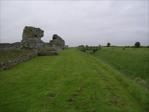
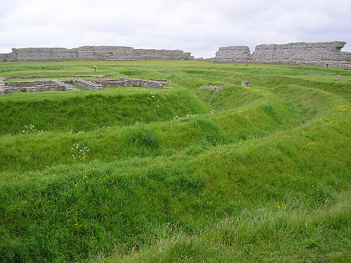
The garrison of the fort - along with Regulbium fort - secured one of the most important port locations in the British provinces, the southern entrance to the Wantsum Canal, the Isle of Thanet and the entrance to the Stour Valley. From here it was relatively easy to cross the Oceanus Britannicus to the Gallic Gesoriacum (Boulogne-sur-Mer). The fort was just north of Sandwich (Kent), near the east coast of Kent. It stood on a low, isolated hill, a spur of the Canterbury Downs, rising 18m above sea level and now entirely surrounded by marshland. Plains spread north and west separating it from the Isle of Thanet, these also extend east and south where the Stour meets the sea. Only in the west and south-west is the swamp belt narrower, from where you can reach the plateau in the interior. It's still a somewhat remote spot today and is the last vantage point off the coast. In Roman times the fort hill was a peninsula and surrounded by the sea on two sides except the south and west. The then navigable Wantsum Canal was a major tidal sluice that guaranteed ships entering the Thames/Thamesis safe passage to London/Londinium without the risks involved in sailing around the island of Thanet on the open sea. It has silted up over the centuries, only marshland and dykes mark the places where brisk shipping traffic was still possible in ancient times. The ruins of the Saxony coast fort are now about three kilometers inland. The ancient harbor is now also swampland. Today there is a factory on the edge of the fort area, the eastern end of the camp was destroyed by erosion from the 15th century and later by the construction of a railway line. The place was also the starting point of Watling Street, a trunk road that led first to London and then via St. Albans and Wroxeter to central Wales and the north. Today only a narrow dirt road west of Richborough reminds of her.
In 1540, John Leland first described the walls of the Saxony Coast
Fort and the foundations of the triumphal arch. More accounts of Roman
remains were written by William Boys in 1799. He mentions the traces of
roads that ran west of the fort. In 1846, during the construction of the
railway line to the east of the fort, remains of flint and brick walls
and an apse were destroyed. In 1849 parts of the amphitheater were
uncovered. In 1887 George Dowker found the remains of ancient stone
buildings with mosaic floors. 350 m further south, during railway
construction work in 1926, the remains of two Romano-British temples, a
burial ground, kilns and other Roman buildings were discovered near the
amphitheater. The ruin site was bought by the Kent Archaeological
Society in 1894, first placed in the hands of a board of trustees and
fenced off; later the area was included in the National Heritage of
England.
The most extensive excavations were carried out by
Joselyn P. Bushe-Fox - on behalf of the Society of Antiquaries of London
and the Minister for Public Works and Labor - with the help of
unemployed miners in the 1920s and 1930s. Between 1959 and 1969 the Kent
Archeological Rescue Unit (KARU) carried out excavations at the fort. In
1965 Ian Archibald Richmond recognized that the foundations at the
center of the fort and fragments of marble belonged to a triumphal
monument. A final summary of the excavation results was published by
Barry Cunliffe in 1968. In 2000, aerial photographs of the ancient city
area were taken. In 2001, 22 hectares of the excavation site were
geophysically surveyed to complete the work. In particular, the exact
course of the Roman roads could be clarified. In 2001 and 2008, English
Heritage archaeologists were able to confirm that the ancient coastline
is almost identical to the current bed of the River Stoure.
The banks of the Wantsum Canal have been inhabited since the late
Bronze Age. The canal itself was probably an important traffic route
from prehistoric times. Traces of a larger settlement from the 7th-6th
centuries have been found near Richborough. century B.C. observed. Early
Iron Age pottery shards, associated in some cases with burials, also
provide evidence of pre-Roman settlement on the hill. At the time of the
Roman invasion, the region was ruled by the Celto-British tribes of the
Catuvellauni, Atrebates and Trinovantes.
In AD 43, the Romans
under Emperor Claudius landed in Britain in their second invasion.
Rutupiae was one of their bridgeheads, where Aulus Plautius went ashore
with most of the troops - probably up to three legions. The Legio II
Augusta under the command of Vespasian entered British soil a little
further south. The army of occupation is now estimated at around 800
ships and 40,000-50,000 men. At that time, this place was a
well-protected lagoon between the coast and the island of Thanet
(Thanatusins). Archaeological excavations have shown that immediately
after landing, the bridgehead was fortified and infrastructure was
built.
Almost all of Richborough Hill was probably built on
extensively during Roman times. Today, only the remains of the Saxon
Coast Fort are visible in the north-east corner, which formed the core
of the port town in the last decades of Roman rule. However, excavations
by Bushe-Fox for the Society of Antiquaries have shown that the fort was
preceded by a number of other buildings, some of military origin and
others apparently of civilian origin. After consolidating their rule in
south-eastern Britain in the mid-1st century, Rutupiae became the most
important naval and supply base for further Roman advances in Britain.
New military roads were laid from here towards Canterbury and London,
numerous wooden structures erected along a grid-like road network to
house the soldiers and supplies. Around the year 85, the appearance of
Rutupiae changed fundamentally, the provisional wooden buildings of the
founding period were removed and partially replaced by more solid stone
constructions and a monumental triumphal arch (quadrifrons). The
locations of such monuments were of great symbolic importance to the
Romans. The erection of the monument is therefore also the strongest
indication that Claudius' invasion troops actually first set foot on
British soil here. Subsequently, however, he was also supposed to
emphasize the subjugation of the local population and Rome's power.
However, the military focus now shifted to the north and west of the
island. Rutupiae was also replaced by Portus Dubris/Dover, 25 km away,
as the main supply and naval base. Despite this, it developed into a
thriving coastal town, and its infrastructure now included a large
mansio (inn). The city was also known throughout the Roman Empire for
the quality of its oyster beds. These are mentioned by Juvenal as being
on a par with those from the southern Italian Lake Lucrin/Lucrinus
Lacus.
Around the middle of the 3rd century, drastic political
and economic upheavals in the empire made it necessary to fortify the
port city, which had apparently already been largely destroyed. Possibly
much of the economic activity had shifted to Londinium. A temporary
fortification was built around the triumphal arch. A large part of the
area of the civil town was leveled, and the Quadrifrons, which has
probably also fallen into disrepair in the meantime, was completely
demolished. The massive defensive walls of the Saxony coast fort were
raised with the demolition material and its marble was burned to lime.
It seems that its construction started around 277 and ended in 285. When
the fort walls were completed, the remaining earthworks and ditches were
removed or filled in. The fortress was probably commissioned by the
usurper Carausius to repel an invasion by troops from the Roman central
government. A new threat now emerged in the form of Anglo-Saxon and
Frankish pirates. They were the vanguard of the later Saxon settlers who
were soon to settle permanently in Britain coming from the North Sea.
The Limes on the "Saxony coast" was set up as an independent military
district or more heavily fortified. At the mouth of the Wantsum was u.
a. also built the camp of Regulbium/Reculver.
359/360 Picts and
Scots broke through the northern border and devastated large parts of
Britain. In order to repulse them again, Emperor Julian Apostate sent
his army commander, the Magister equitum per Gallias Lupicinus, on the
march, who soon afterwards arrived in Rutupiae with an army of Herulian
and Bataver mercenaries and marched with them first to Londinium in
order to proceed from there to plan. In 367, the Attacotts, Picts and
Saxons invaded Britain simultaneously, annihilating or scattering the
Roman forces stationed on the island, killing their general, the Comes
Maritimus Nectaridus, and besieging the Dux Fullofaudes in his fortress.
After that, a usurper, Valentinus, seized control of the British
provinces. In 368 the Comes Flavius Theodosius landed in Rutupis on
behalf of Emperor Valentinian I with his army, quickly put down
Valentinus' rebellion, secured Hadrian's Wall, defeated the invaders and
thus restored the Roman order on the island - for the last time - again.
It is likely that the gradual decline of Roman Britain began in the
second half of the fourth century, with its infrastructure falling apart
more and more. Certainly there were still functioning trade networks, as
can be seen from the pottery finds for this period, but local production
also declined. However, the forts in East Kent and especially that in
Richborough probably still played an important role in the last years of
the Roman province. There is some evidence of stamped lead ingots and
other late fourth-century finds recovered there. In the north-west
corner of the fort, the remains of a late antique church have been
unearthed and recent investigations have shown that the vicus was even
expanded somewhat in the fourth century. During the excavations, more
than 20,000 coins from the period between 395 and 402 were also found on
the site of the fort, far more than in the rest of Britain. Among them
were a lot of smaller denominations, a strong indication that Rutupis
was an important economic and financial center in the region until the
end of Roman rule. The fort at Richborough was arguably one of the last
Roman strongholds in Britain to be vacated of its regular garrison.
In the early 5th century, the Western Roman administration and army
in Britain had already dissolved, but the former Saxon coastal fort was
still very busy. When Augustine of Canterbury visited Britain in 597, he
probably landed at Rutupis. With the landing of the missionary sent by
Pope Gregory I, contact with Rome was restored. Due to its favorable
location on the Channel coast, this place continued to be populated. The
Romano-British King Vortigern made the island of Thanet available for
settlement to Anglo-Saxon mercenaries led by Hengist and Horsa. From
there the Anglo-Saxon occupation of Britain would begin in 449. Towards
the end of the 5th century Thanet was part of the first Anglo-Saxon
kingdom of Kent. During excavations in 2008 one encountered u. a. also
on a dock from the Middle Ages. Proof that the place - and probably also
the fort - was still used as a harbor at that time. The Wantsum Canal
began to silt up from the 12th century, the last ship passed through it
in 1672, and the port also had to be abandoned after that.
This barrier was probably built in great haste during the invasion of Britain, 43 AD, to secure the landing zone against surprise British attacks. From the fortifications, traces of a double ditch could be observed on the inside of the Saxony coast fort (to the north-east). It was probably a 2700 m long, crescent-shaped barrier, consisting of a peat-earth wall with palisade posts to the east and two V-shaped ditches in front (approx. 650 m are still visible today), which runs from north to south, parallel to the coastline at that time. In the north-east the ditches ended in marshland, in the south they were destroyed during the construction of a railway line. The inner ditch was 3.5 m wide and 2 m deep, the outer one was slightly narrower and ran 2 m away. Not far from the west gate of the Sachsenküstenkastell, these ditches were interrupted by a 9 m wide paved dam, where - on the land side - a 3.25 m wide gate broke through the wall, which was secured by a wooden tower resting on four posts. The camp arguably extended far east to the present-day line of cliffs and marshland. In the west and especially in the east of Walls, the remains of Roman buildings were found. In particular, near the present-day cliff, traces of more than half a dozen elongated wooden buildings, 35 m long and 8 m wide, arranged in rows, have been found. The purpose of these buildings, it can be assumed, was to create storerooms for housing military goods and equipment during the first years of the conquest. A well shaft smeared with clay was located 6 m east of the Saxony coast fort. The contents of this well showed that it had been filled in just ten years after the invasion. Ceramics from the late Celtic and Claudian periods, coins from Agrippa, Tiberius and Claudius were found there as accompanying finds, objects from the time of Claudius were found in the layers above. How long the early military occupation of the site lasted cannot yet be said with certainty. It was probably short-lived; estimated to be around AD 50. It is only clear that the mound was used for other purposes until the last quarter of the century. The earth wall was leveled and the ditches filled in.
In the middle of the 3rd century the houses around the triumphal arch were apparently cleared or demolished and the area was surrounded with three pointed ditches and an earth wall. The ditches ended at Mansio and Watling Streets, where the main gate of the fort is believed to have been. The fortifications were probably in use for 25-30 years.
The Saxony coast fort stood on slightly elevated ground in the north of the bay. The complex from late antiquity still had the rectangular floor plan typical of mid-imperial forts, but no longer had rounded corners. Furthermore, no rear earth wall could be detected. Gates were let into the defensive wall on two sides, each flanked by two towers. At 2.5 hectares, it is somewhat smaller than the neighboring Regulbium (Reculver), but the walls of the fort were much more massive and were probably later modernized again. The eastern side of the fortress is now completely destroyed. Debris from the east wall was still used as a dock in the 15th century.
Large sections of the wall, measuring 3.3 m at the base, are still
standing up to a height of eight meters. This was also the height of the
battlements, which were probably protected by battlements about two
meters high. The wall was mainly built of flint, but many other types of
rock, such as e.g. B. Limestone from the area were used for this
purpose. The north wall z. B. is likely to consist largely of material
from the broken off triumphal arch. A striking change in the
construction of the wall can be clearly seen at one point here.
Presumably this section had been erected by another construction crew.
The core of the wall consisted of quarry stone bound in cement,
which was covered with roughly hewn blocks. Six two-row rows of bricks
(they also contain a small amount of reused roof tiles) were inserted
one meter apart. Smaller square indentations (so-called putlog holes),
in which the support beams of the scaffolding were once anchored, are
also clearly visible everywhere. The outer facing has now largely
disappeared as its stone material was used to build the town walls of
nearby Sandwich. The large holes in the wall visible today were also
caused by stone robbers.
The corners of the wall were protected by four cantilevered,
semi-circular massive towers, while the twelve intermediate towers and
four gate towers were rectangular and accessible from the inside. Their
floors were made of wood. They probably housed guard rooms, living
quarters or storage rooms. Their lowest floors consisted of a layer of
pebbles, which can still be seen in the tower between the northeast
corner tower and the northern hatch. There was a latrine in the
intermediate tower north of the west gate. The foundations of the
southwest corner tower can still be seen today. On the corner towers
there were probably heavy slingshot guns (ballista).
The two
slightly offset gate systems in the east (port side) and the main gate
in the west (land side) were each provided with a passage. The
guardrooms were above the archways. They were flanked by two rectangular
towers. They also gave access to the battlements. On the north and south
walls, two small slip gates were let into the central intermediate
towers (on their east and west sides). The northern one has been
preserved to its original height.
Two V-shaped defensive ditches also surrounded the fort walls as an approach obstacle. The inner one was 10 m wide and 3 m deep, the outer 8 m wide and 2 m deep. A third ditch, between the two main ditches, at the west gate was probably the result of a survey error. It was therefore filled up again soon after it was excavated.
In the 4th century almost all the buildings inside the fort were made
of wood. A total of 17 of them have been archaeologically proven. These
were mostly simple, long rectangular timber frame buildings. The
partition walls were made using half-timbering technology. In the
southeast corner were two larger storage buildings (Horreum). In the
centre, on the site of the former triumphal arch, the Principia of the
camp were erected.
In the 5th century a small chapel with a
hexagonal tiled basin (probably a baptismal font) was built on the
north-west wall over the remains of a 1st-century wooden building. It is
one of the very rare testimonies to the activities of burgeoning
Christianity in Britain and may have been in use for some time after the
Roman army had left.
In the north-eastern part of the fort area, a small, east-west
oriented bathhouse (row bath type) with a pool attached to the side was
uncovered. It was probably the only stone building in the late antique
camp and was built directly over the remains of the earlier mansio and
probably at the same time as the fort (a coin of Emperor Tetricus,
268–273 AD, found under the floor of the frigidarium) and probably
abandoned in the 5th century.
A total of three rooms could be
examined during the excavations, one of which could not be heated. It is
located on the east side of the building and measures 3.40 m × 3.60 m.
On the north side there is a piscina that has been remodeled several
times and was built into a rectangular niche (2.40 m × 1.65 m). To the
west was the 2.70 m × 3.60 m tepidarium, followed by the caldarium. Both
are equipped with a hypocaust heater, the praefurnium of which is
located on the west side of the caldarium. The associated water basin
was located in an apse attached to the north side.
At the end of the 4th century, according to the Notitia Dignitatum, a prefect with a vexillation of the Legio II Augusta was stationed in the castle of Rutupis under the command of the Comes litoris Saxonici per Britanniam (Praefectus legionis secundae Augustae, Rutupis). The camp of Rutupis was not big enough to hold the whole legion. The resulting vexillations were probably already scattered throughout the Western Roman Empire at that time, since the army reforms of Emperors Gallienus and Diocletian assigned the best soldiers to the mobile field army (Comitatenses).
The first temporary fortification was followed by a phase of
development during which the ditches were leveled, a road network laid,
and 12.28 m × 9 m wooden structures, including two warehouses, were
erected. From 70 Rutupiae had established itself as an important trading
port. The warehouses were demolished and replaced by narrow,
long-rectangular wooden buildings with a porch and street-facing
commercial and living quarters at the rear (strip house).
The
multi-phase civil settlement (at first probably just a vicus) arose in
pre-Flavian times. Its center was to the west of the triumphal arch in
an area surrounded by earthworks and continued beyond these ramparts.
Military warehouses were gradually being replaced by residential
buildings as early as the 1st century. Along Watling Street and just to
the west of the Late Antique fort, behind a ridge, an extensive regular
grid of streets and smaller foundation ditches of stone buildings
emerged. However, most of the buildings were made of wood. In some, oil
lamps were made or metal worked. It must have been a city-like
settlement of about 21-25 hectares, which reached its heyday and
greatest extent in the 2nd century. A burial ground and the remains of
two small temples (Temple 1 and 2) were also found. After 270 AD the
city had apparently already been abandoned by most of its inhabitants.
Their terrain was then leveled and the fort of the Saxony Coast Limes
was built on it - over the area of six former insulae.
Little is known about him. It was located to the east of the fort grounds, its last remains were destroyed during the construction of the railway. The harbor provided a safe anchorage, protected (geologists believe) by the natural breakwater of Stonor Beach. In the 3rd century, sedimentary deposits from the River Stour began to silt up the port area, particularly to the west of the town, which may have been one of the reasons for its decline during this period.
This multi-phase building stood on the sea-facing side of the city area. The exact purpose of the building is not entirely clear, but it seems almost certainly to have served as a hostel (mansio) for travelers and state officials. In the 1st century, the mansio was still made entirely of wood, and its rooms were arranged around a large courtyard. It was completely rebuilt in stone around AD 70 and expanded even further to the northeast around AD 85. It was then rebuilt several times and completely rebuilt again during the 2nd century and also equipped with hypocaust heating for a bathroom. The late 3rd-century fortifications around the triumphal arch cut through the remains of dwellings but spared the mansio. It must have been intact at this point. Perhaps it served as accommodation for the fortress commander. The building stood until the late 3rd century. After it was destroyed by the construction of the Saxony Coast Fort, the camp baths were built to the west of its remains.
Possibly to celebrate the victory of Gnaeus Iulius Agricola at the
Battle of Mons Graupius or the completion of the conquest of Britain
under Domitian, a roughly 45 × 32 m triumphal arch (Quadrifrons or Great
Monument) was erected at Rutupiae. The four-arched monumental building
clad with white Carrara marble from Italy, originally around 25 m high,
was probably also intended to symbolically mark the entrance to Rome's
new province of Britannia (accessus Britanniae). Such monuments had also
been erected in other provincial towns (e.g. the so-called Heidentor in
Pannonian Carnuntum). Its cruciform (1.5 m wide, north-south arm 25 × 21
m long, west-east arm 14 × 7 m long), made of flint stone bound in clay
and ten meters deep, are still clearly visible today. They were also
known as Saint Austin-Cross since the 17th century. They were long
thought to be the base of a large lighthouse, or part of its internal
support structure. The four main pillars were flanked by four archways,
which formed a cruciform vault in the middle. The western and eastern
arches were much wider and higher and served as a passage that could be
entered via stairs on both sides. A box-shaped superstructure with a
flat roof was placed over the arches. He may have carried an equestrian
statue or group of figures (quadriga). Coins of Vespasian (69-79) and
Sami ceramics from around 60-90 AD were found as additional finds, and
pottery shards from 75-120 AD were still found in the sand layer above.
Individual bronze finds and fragments of worked marble give a good
idea of how imposing it might have once been. Roman numerals were carved
into some of the marble fragments, all in small letters. In all cases
the numerals were placed on the back of the slab and are therefore
either associated with a reuse of the marble or, more likely, served as
a marker to place the slabs in the correct places on the structure. It
may have been dedicated to the sea god Neptune, which may have been
reflected in its facade decoration. It is possible that this monument is
also related to a monumental inscription found in Rome, which tells of
the submission of eleven British kings to Emperor Claudius. The
inscription was there on a triumphal arch erected for Claudius. In the
middle of the 3rd century it was fortified with earth walls,
additionally surrounded by three V-shaped ditches and used as an
observation and signaling station. Towards the end of the century
(275-300) it was finally broken off.
The amphitheater has been known since the 18th century. It was about 400 m south-west of the Saxony coast fort on the highest point on the peninsula. It is believed to have been built in the late 3rd century for the garrison of the fort. It was an ellipsoidal facility with two main entrances in the longitudinal axis and massive structural structures in the area of the transverse axis within the spectator tiers. The amphitheaters in Britain were not usually built entirely of stone. Excavation in 1848 and recent geophysical surveys within the area revealed an arena surrounded by sloping clay and mortar masonry substructures twelve meters wide and two meters high. The wooden seats for the spectators were attached to them. Only a slight depression, the 62 × 50 meter arena, can be seen from the amphitheater today. The magnetometer investigations also showed large stone circle areas under the spectator benches, which had very deep foundations. On the narrow sides, on the north-west and south-east sides, there is evidence of two additional gates that appear to have been flanked by towers. It seems that the amphitheater also superimposed imperial settlement structures.