Location: 3 mi (2 mi) West of Amesbury, Wiltshire Map
Construction: 2500 BC
Info: 01980 622833
Open: Apr & May:
9:30am- 6pm
Jun- Aug: 9am- 7pm
Sep & Oct: 9:30am- 6pm
Nov- Mar:
9:30am- 4pm
Closed: 20- 22 June, 24- 25 Dec
www.english-heritage.org.uk
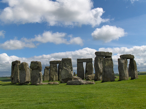
Stonehenge is a Neolithic structure built over 4,000 years ago and
used at least until the Bronze Age near Amesbury, England.
It
consists of a ring-shaped mound of earth, inside which are various
formations of worked stones grouped around the centre. They are called
megaliths because of their gigantic size. The most striking of them are
the large circle of formerly 30 standing cuboids, which originally had a
closed ring of 30 capstones on their upper side, and the large
horseshoe, originally made of ten such columns, which were connected in
five pairs by a capstone. the so-called triliths. Within each of this
horseshoe and circle stood two figures similar in form: both of much
smaller, but formerly twice as many, stones.
These four
formations are complemented by the "Altar" near the center of the
complex, the so-called "Sacrificial Stone" within - and the Heelstone
well outside the northeast exit. In addition, three concentric circles
of holes were created in the ring wall and in the largest of them four
menhirs were arranged in a rectangle, the short sides of which lie
parallel to the longitudinal axis of the monument. Other buildings from
the megalithic era - especially burial mounds and two structures that
are called racecourses - can be found in the area. In addition, there
are the remains of the so-called Processional Way, which extends from
the said exit to the right to the banks of the Avon. The radius, which
leads downwards into the entrance of the monument, then points in its
extension to the south coast of England, about 50 km away;
interestingly, exactly where the rivers Avon and Stour join the English
Channel (see Christchurch Harbour). According to this, there could have
been processions that on certain days began in the morning in a
north-easterly direction, followed the apparent path of the sun down
towards the coast and ended in the evening, returning via the entrance
to the monument.
Recent research suggests that Stonehenge - and
with it the culture that built it - should not be viewed in isolation
from similar structures. At the point where the Processional Way meets
the Avon lies the smaller Bluehenge. There may also be a connection with
the nearby construction of Durrington Walls or a motive common to the
various peoples that led to the development of megalithic cultures.
There are various hypotheses, some of which complement one another
and some of which contradict one another, about the occasion and
ultimate purpose of this complex, which was designed to be extremely
complex. They range from the self-portrait of a primal-political
alliance of two formerly hostile tribal organizations (see double
execution of the formations and the size hierarchy of the menhirs) to a
religious burial or cult site to an astronomical observatory including a
calendar for the sowing and harvest times.
All of these
hypotheses, including the more purely speculative ones, agree on one
point: the architects of the monument succeeded in aligning the
horseshoes and the stones placed vertically in front of their openings
exactly with the sunrise at that time on the day of the summer solstice.
The path from the simplest to the most complex, final version of
this system can be divided into at least three sections:
The
beginning of the first phase, during which a circular mound with a
surrounding ditch was built, is dated to about 3100-2900 cal B.C. and
lasted until about 2900–2600 cal B.C. (or even up to 2100 BC).
The
second phase with the Aubrey Holes as the largest of the three circles
of holes mentioned above, plus other holes outside the ring wall, dating
from the first half of the third millennium BC, lasted until about
2500/2400 cal B.C. (or until 2000 BC).
Stone constructions were built
from around 2400 to 1500 BC. B.C., whereby the following explanations
radically changed the earlier ones several times.
According to
the first vague indications, the beginnings of the complex as an actual
megalithic monument go back much further than previously assumed; it
seems so already around 3000 BC. to have given a first version of stone
structures. However, the further statements in this article refer to the
dating that has so far been assumed to be certain.
The latest
research suggests that the place where the remains of the monument can
be viewed today had a special ritual significance for people 11,000
years ago.
The monument has been owned by the English state since
1918; It is managed and developed for tourism by English Heritage, and
its surroundings by the National Trust. UNESCO declared the Stonehenge,
Avebury and Associated Sites a World Heritage Site in 1986.
In
2019, Stonehenge was visited by 1.6 million people.
The name Stonehenge is already attested in Old English as Stanenges
or Stanheng. While the first part of the name is the Old English word
stān "stone", there is uncertainty about the second element. It could be
hencg "angel, hinge" or a substantive derivation from the verb hen(c)en
"to hang", which would then mean "gallows". In fact, medieval gallows
had two feet and thus resembled the triliths in the center of the
monument. The attempted interpretation as "stones hanging (in the air)"
lacks semantic consistency.
The second part of the name, Henge,
is now used as an archaeological term for that class of Neolithic
structures consisting of a ring-shaped raised enclosure with a ditch
running along the inside. Stonehenge itself is what is known as an
atypical henge in current terminology, as the moat lies outside the ring
wall.
The complex was continuously changed or built in several
phases. These activities extend over a period of about 2000 years.
However, the site was demonstrably in use before the first stone
construction. Three large putative postholes located outside the ring
wall near the present car park date from the Mesolithic period, around
8000 BC. The remains of cremations dating back to between 3030 and 2340
BC were found in soil samples around the place of worship. were dated.
As a result, the site was already in use as a burial ground before the
stones were set up. The most recent cultic activities (druids, emergence
of the Avalon saga?) date from around the 7th century AD, and the tomb
of a decapitated Anglo-Saxon is worth mentioning as an artefact.
It is difficult to date the various phases in the design of the monument
and to understand their meaning, since earlier excavation methods did
not meet today's standards and there are still hardly any theories that
would allow one to empathize with the thoughts and actions of the people
of that time .
So remains u. unsure what the function of the
holes found in the ground was. Some scholars contend that their original
purpose was to accommodate buttresses for the purpose of a no less
speculative roofing of the square. Others argue that such hypothetical
tribes were phallic symbols or totem poles that were later replaced by
towering rocks as technological advances and cultural-demographic
changes such as population growth and the consequent increase in labor
force increased.
Cognitive archaeologist Colin Renfrew suggested
that such constructions were intended to impress the viewer from a
distance, i. i.e. to make enemies think twice about attacking. The
gradual expansion of the facilities is thus interpreted as a symbolic
'arms race' among neighboring tribes - possibly as an expression of the
'phallic threat', as it could often have been preserved as a genetic
disposition to this day. This thesis is supplemented by the assumption
that the structures of Stonehenge, which ultimately changed again and
again in the direction of increasing complexity, reflect memories of the
course of military conflicts, including the displacement of an
indigenous population that had been stronger in number in the meantime.
Such a process could be reflected in the temporarily completely (?)
removed bluestones from the ring wall. The fact that this culture was
ultimately included in the dominion of the victors despite being
inferior – the latter sometimes expressed their being through the two
sarsen formations built from fundamentally much larger stones – would
then correspond to the result of a territorial dispute that was peaceful
, with the founding of a new (mixed) culture.
The fact that only
little material has been discovered so far from which 14C data could be
obtained makes it even more difficult to understand the development of
these cultures over time, and thus also the gradual changes to the shape
of the monument that were only discovered archaeologically. The sequence
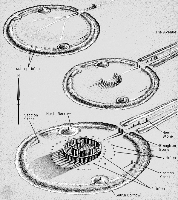
of these interventions, which is mostly accepted today, is explained in
the following text with reference to the map sketch shown. The megaliths
that have survived to the present are highlighted by coloring their
outlines (blue, brown and black); the capstones of the two sarsen
formations were left out for reasons of clarity and there is speculation
about the disappearance of the rest of the heavily damaged complex. The
monument was partly used during the feudal phase of England as a quarry
for the construction of churches, fortresses and palaces of the
powerful, but there are also clear traces of targeted destruction.
Carefully dismembered columns, shattered images, etc., modern archeology
mostly interprets in terms of the annihilation of a culture by the
succeeding victors; parallel it appears from about 1400 cal B.C. to have
come to a change in burial customs (from megalithic communal tombs to
tombs for individual rulers), which can also be interpreted in this way.
The heelstone and sacrificial stone, and with them the openings of
the two central horseshoes, were aligned with the position of midsummer
sunrise; also, among others, the four stones of the rectangular
structure on the ring wall seem to have something to do with different
periodicities of celestial mechanics. For these reasons, Stonehenge is
often assumed to have been an ancient observatory, although the precise
nature of its use and its importance, such as for sowing and reaping at
the best possible times (see below), are still debated.
Description of the stones (from inside to outside)
The Altar Stone: A
five meter block of green sandstone closest to the center of the
complex.
Next to that is the small horseshoe: it housed 19 stones
made of dolerite, a very hard basalt from the Preseli Mountains in South
West Wales. Because of their bluish shimmer, the megaliths made of this
material are also known as blue stones. Their height reaches up to 2.8 m
(towards the open legs of the horseshoe it decreases to 70 cm), and
their shape is cylindrical, not conical like the otherwise widespread
obelisks. A distinctive feature is that the two menhirs to the left and
right of the base stone of this horseshoe show a cross-section that
corresponds to the geometry of a tongue and groove connection from the
carpentry trade. However, a concrete, mechanically connecting task of
both forms can be ruled out, because the stones are a good 3 meters
apart. It is either a functionless relic from earlier construction
versions (from Stonehenge 3 I) or a function in the sense of a pure
symbol.
The big horseshoe embraces the small one. It consisted of ten
sandstone blocks (so-called sarsen), which were connected in pairs by a
third on their upper side. Over 5 m high, they weigh up to 50 tons and
must have been moved on sleds pulled by an estimated 250 men, on
inclines of up to 1000 men. Alternatively, the use of draft animals is
discussed.
The mighty sarsen horseshoe is followed by the circle of
originally 60 bluestones. They are, on average, a fair bit smaller than
those of the bluestone horseshoe and are tapered (not cylindrical) in
shape.
The formation of this bluestone circle is surrounded by
another circle, which in turn was constructed from sarsen: originally 30
in number, approx. 4.5 m high and connected to one another by 30 blocks
placed on top, so that a closed ring structure was created.
The
sacrificial stone, whose name is also misleading because it is easily
confused with the altar stone, is currently located in the middle of the
north-eastern opening of the ring wall, at the exit of the complex, so
to speak. The audio guide that takes visitors around the monument notes
that this stone was probably standing upright, and that its red spots
are not blood (which would have long since weathered and washed away)
but inclusions of iron oxide . The naming "victim stone" is therefore
more than questionable.
The Heelsstone or Friars Heel, in German as
"heel stone", is relatively far outside the ring wall.
The four
station stones.
Other special features:
The Aubrey Holes (56
pieces)
The Y and Z holes (29 and 30 pieces)
Laser scans of the
surfaces of all surviving 83 monumental stones at Stonehenge were made
on behalf of English Heritage. A total of 72 previously unknown
engravings were discovered. 71 of them show axes (up to 46 cm tall), one
a dagger. The site resembles the stone circles of northern Scotland
known as the Ring of Brodgar.
In 1995, the excavation findings from the 20th century were evaluated
and divided into three phases based on 14C dating. A slight change made
in 2000 to an older dating is based on the meanwhile improved method
(Bayesian statistics) of evaluating the 14C data. By 2009, other minor
modifications were added.
Based on their own evaluations,
employees of the most recent data collection presented a new study at
the end of 2012, in which they proposed five phases instead of the
previous three – also using a Bayes classifier. A similar interpretation
had already been attempted in 1979 but received little attention.
stonehenge 1
The first building was about 115 m in diameter and
consisted of a circular rampart with a ditch surrounding it (7 and 8),
according to the classification an atypical henge complex. Opposite the
large north-east opening of this ring wall was a smaller one to the
south (14); Bones of deer and ox were placed at the bottom of the ditch.
These bones were much older than the antler picks used to dig the ditch
and were well preserved when buried. The start of the first phase is
estimated at approx. 3100-2900 cal v. dated. At the outer inboard edge
of the area thus bounded was a circle of 56 holes (13), named the Aubrey
Holes after their discoverer, John Aubrey.
A second rampart (9)
now surrounding the outer ditch could also come from this phase
(Stonehenge 1), which can be defined as pre-megalithic.
stonehenge 2
Visible remains that could safely indicate the
appearance of building structures during the second phase no longer
exist. The dating was therefore rather indirect, including finds from
"grooved ware" (English Grooved Ware), which belong to this period (late
Neolithic). Shapes of holes detectable in the ground could be found in
the early third millennium BC. to have been created and to have carried
posts. Other posts may thus have stood in holes discovered at the north
entrance; two parallel rows of posts would have run inwards from the
south entrance. However, at least 25 of the Aubrey Holes contained
cremation remains dating from about two centuries after the holes were
dug. The holes were therefore in use as burial sites - they may have
been converted for this purpose, or the hypothetical posts were removed
at each burial. The remains of thirty other cremations were discovered
in the ditch and at other points on the site, mostly in the eastern
half. Unburned pieces of human bones from this period were also found in
the ditch.
Stonehenge 3 I
In the center of the sanctuary,
around 2600-2400 B.C. Two concentric semicircles of 80 stones, the
so-called bluestones, were laid out. Although they were later moved, the
holes in which the stones were originally anchored (the so-called Q and
R holes) remain detectable. Again, there is little dating evidence for
this phase. As mentioned, the bluestones come from the area of the
Preseli Mountains, which are about 240 km from Stonehenge in what is now
Pembrokeshire in Wales. The stones are mostly dolerite interspersed with
some inclusions of rhyolite, tuff and volcanic ash. They weigh about
four tons. Known as the Altar Stone (1), the six-ton stone is the only
one made of green sandstone. It is twice the size of the largest of the
stones from the bluestone horseshoe (which does not yet exist at this
stage) and is also from Wales. It may have stood upright in the center
as a large monolith, perhaps it was intended to lie flat. Many of the
early megalithic complexes represent burial facilities: the giant tombs,
also known as devil's beds.
At that time, the entrance was
widened so that its two side parts now pointed exactly to the positions
of the sunrise at the summer and winter solstices at that time. As
mentioned, the blue stones were removed after a while and the remaining
holes (Q; R) were filled.
The Heelstone (5) may also have been
placed outside the north-east entrance during this period. However, the
dating is uncertain, in principle every section of the third phase is
possible. Furthermore, pressure accumulations in the immediate area of
the entrance are sometimes interpreted in such a way that up to three
menhirs could have stood side by side here, but such traces also result
from the repeated change in the position of a single menhir. In any
case, the fact is that there is only one in the entrance area today. It
is 4.9 m long, probably fell down a long time ago and is called a
sacrificial stone (4).
Also included in phase 3 is the erection
of the four station stones (6) and the construction of the avenue (10),
a path bordered on both sides by a ditch and a mound of earth, also
known as the Processional Way, which leads to the River Avon over a
distance of 3 km. Investigations of this route showed that it ran
through a meltwater channel from the last ice age, which was only
slightly reworked.
At some point in the third construction phase,
trenches were dug both around the two station stones of the north-south
diagonal and around the heelstone, which must have stood as a single
monolith at least since then. This phase of Stonehenge's construction is
that which the archer of Amesbury may have seen; towards the end of the
phase, Stonehenge appears to have replaced Avebury's henge as the
region's central cult site.
Stonehenge 3 II
At the end of the
third millennium BC, between about 2550 and 2100 BC according to
radiocarbon dates. BC, the main building activity took place. Now the
two sarsen constructions (grey in the plan) were erected, which
determine the overall impression of Stonehenge today. Many of these 74
megaliths, the smaller around 25, the larger around 50 tons, come from a
quarry near Marlborough 30 km to the north, as geochemical tests in 2020
showed.
30 of these blocks formed a circle with a diameter of
thirty meters. The fact that there were once 30, grouped into a complete
circle, could only be proven in 2013, when a long-lasting drought caused
differences in the vegetation to show the compaction in the subsoil,
even where the stones themselves are no longer there. The horseshoe from
the 5 triliths was then set up within this circle.
The surfaces
of all sarsen are hewn and have been smoothed. The capstones of the
sarsen formations (circle + horseshoe) have two holes worked into their
underside, which combine with the pegs at the top of the supporting
stones to form a version of the tongue and groove connection. A symbolic
purpose of this measure cannot perhaps be ruled out, but it certainly
served to wedge the elements together. A similar pattern is found on the
end faces to the left and right of each of the 30 capstones of the
circle, and they were also given the shape of carefully crafted segments
of a circle to connect them to form a perfect ring.
Furthermore,
some of the sarsen have carved or scratched images. Perhaps the oldest,
a flat rectangular figure at the top of the inside of the fourth
trilith, may represent a mother goddess. Perhaps closer than this
interpretation would be to think of an abstract representation of the 4
station stones opposite this symbol - but here too it is still unclear
what their meaning is. As for the other symbols, fewer questions remain.
Worth mentioning in particular on stone 53 is the depiction of a bronze
dagger and fourteen ax heads, further depictions of ax heads can be
found on stones 3, 4 and 5. It is difficult to date the depictions, but
there are similarities to Late Bronze Age weapons. On the other hand, it
is not easy to decide whether these depictions were attached to the
megaliths that were still in the process of being made, or later,
possibly on working platforms erected for this purpose.
Stonehenge 3 III
At a later point in the Bronze Age, the bluestones
appear to have been raised again for the first time. However, the exact
appearance of the site in this period is not yet clear.
Stonehenge 3 IV
At this stage, roughly between 2280 and 1930 B.C.,
the bluestones were rearranged again. One part of them was placed as a
circle between the sarsen circle and the sarsen horseshoe, and the other
part was placed in the form of an oval around the center of the
monument. Some archaeologists believe that an additional batch of
bluestone had to be brought in from Wales to make this new building
project possible. The altar stone may have been slightly relocated
parallel to the construction of the oval, possibly away from the center
to its present position (closer to the base of, among other things, the
sarsen horseshoe). The work on the bluestones of this phase (3 IV) was
carried out rather carelessly compared to the work on the sarsen in the
previous phases. The bluestones, which were initially removed and then
set up again, were poorly embedded in the ground, and some of them soon
fell over again.
Stonehenge 3 V
Soon after, the north-east
half of the bluestone oval constructed in Phase 3 IV was removed,
creating the arcuate formation we know today as the bluestone horseshoe.
This structure mirrored that of the Sarsen Horseshoe, except that it was
constructed from discrete and significantly smaller, but nearly double
the number of stones: 19 to the 10 supporting stones of the Sarsen
Horseshoe. This reorganization of the monument is dated from 2270 to
1930 BC. dated. This phase (Stonehenge 3 V) thus runs parallel to that
of Seahenge in Norfolk.
Stonehenge 3 VI
Around 1630/1520 BC
B.C., two further rings of pits were drilled just outside the Sarsen
circle, in addition to the circle of Aubrey pits found opposite on the
inland periphery of the ring wall. The new circles are called the Y and
Z holes (11 and 12). Their 30 and 29 holes, respectively, were never
occupied by stones, otherwise soil compaction could have been detected
in them due to the pressure exerted by the stones. The Stonehenge
monument appears to date from around 1600 to 1400 BC. to have been
abandoned, possibly in connection with the decline or displacement of
the culture of its creators by a subsequent one. The holes filled up
over the next few centuries, the top layers of this material date from
the Iron Age.
The orientation was such that on the morning of Midsummer's Day, when
the sun rises furthest to the north-east in its course of the year, it
rises directly over the Heelstone and sends its rays in the direction of
the structure. The meaning of the long shadow at the moment of sunrise
that the Heelstone cast on this occasion, among other things, on the
altar stone, the base of the bluestones and the sarsen horseshoe, could
have had, is not known.
However, it is taken for granted that
this architecture was, on the whole, consciously conceived and realized.
The point at which the sun rises on the date of summer solstice is
directly related to latitude. In order to implement the orientation of
the monument according to a plan that provides for this, it must have
been calculated or practically determined according to its relative
position (51° 11′). This approach should therefore have been fundamental
to the placement of the stones in at least some of the phases of
Stonehenge. The heelstone and with it the symmetry axis of the horseshoe
are therefore interpreted as components of a solar corridor that
includes the rise of our day star.
Among other things, Stonehenge
may have been used to predict the summer and winter solstices and the
vernal and autumnal equinoxes, seasonal turning points important to an
agricultural culture.
According to an earlier research finding,
the moon's course would play a far greater role than previously assumed.
In 1963, Gerald Hawkins described in the article Stonehenge Decoded in
the journal Nature that the 19 megaliths of the bluestone horseshoe can
be used to calculate the so-called Meton cycle - an approximately
19-year period after which the summer solstice and lunar eclipse occur
on the same day fall. Since the latter event always includes the full
moon and this leads to particularly violent tidal currents, a
correspondingly strong low tide can be expected in the Avon at noon.
The Neolithic circle of Stonehenge, which begins with the 1st phase
around 3100/2900 cal B.C. B.C., has construction features and
characteristics with the Aubrey holes on the outer edge which, according
to the computer scientist Friedel Herten and the geologist Georg
Waldmann, indicate a lunisolar calendar. Their 2018 study suggests that
the lunisolar calendars of Stonehenge and the Nebra Sky Disc were based
on an 18.6-year cycle and relied solely on observing the movement of the
northern lunar swells. With both systems, solar and lunar eclipses could
have been predicted to the day more than 5000 years ago.
Roger
Mercer has claimed that the bluestones are exceptionally finely worked.
He postulated that they were once brought to Stonehenge from an as yet
unidentified older monument in Pembrokeshire. It is true that most other
archaeologists agree that the bluestones were worked with no less care
than the sarsen stones. However, if Mercer's reasoning were correct, the
bluestones could have been transported from that location in order to
reinforce a newly established alliance with the two sarsen formations
through their composition. On the other hand, the interpretation that
the Bluestone structures symbolize an inferior, and therefore 'small'
enemy in this alliance would not speak against it either: The Bluestones
are, as I said, relatively tiny, downright dwarfs compared to the giants
of the Sarsen. Likewise, the change to the order proposed by Mercer in
the sense of the dating outlined above (according to which the
Bluestones were first in the Stonehenge area, then apparently
temporarily displaced 'by the Sarsen') would not fundamentally change
the political character of his thesis.
Complementing this
approach, some archaeologists have suggested an interpretation that
suggests that the very hard igneous material of the bluestones and the
relative softness of the blocks of sarsen made of sedimentary sandstone
could be symbolic of an alliance between two cultures or groups of
people originating from each other areas and therefore must have had
different backgrounds.
New analysis of contemporary burial sites
nearby, known as the Boscombe Bowmen, has shown that at least some of
the people who lived at the time of Stonehenge 3 may have come from what
is now Wales. Also, an analysis of the crystal polarization in the
bluestones revealed that they could only have come from the Preseli
Mountains.
Bluestone outcrops resembling the Stonehenge 3 IV
small horseshoe have also been found at the sites known as Bedd Arthur
in the Preseli Hills and on the island of Skomer off the south-west
Pembrokeshire coast.
Aubrey Burl claims that the bluestones were transported from Wales
not solely by humans, but at least part of the way by Pleistocene
glaciers. However, no geological evidence of such transport between the
Preseli Mountains and Salisbury Plain has been found. Furthermore, no
other specimens of this unusual dolerite stone have been found near
Stonehenge.
There is much speculation about the method of
construction of the facility. If the bluestones didn't change places by
glacial shipment, as Aubrey Burl suspects, but were transported by human
hands, there are many methods of moving giant stones with ropes and
wood.
As part of an experiment in 2001, an attempt was made to
transport a larger stone along the assumed land and sea route from Wales
to Stonehenge. Numerous volunteers pulled him overland on a wooden sled
and then loaded him onto a replica of a historic boat. However, this
soon sank together with the stone in rough seas in the Bristol Channel.
A second experiment in August 2012, however, was successful and brought
a bluestone by sea via the Bristol Channel and the Avon using Stone Age
methods. Archaeological experiments in 2016 showed that land transport
with sleds on a route made of halved tree trunks was also possible with
remarkably little effort.
It has been suggested that A-shaped
wooden frames, similar to a roof construction, were used to erect the
stones and move them into a vertical position with ropes. For example,
the capstones could have been gradually raised with wooden platforms and
then slid into place at height. Alternatively, they could have been
pushed or pulled into position up a ramp. The carpenter's tenon joints
on the stones suggest that the builders already had woodworking skills.
Corresponding knowledge should have been a great help in the conception
and construction of this monument.
It has been suggested by
Alexander Thom that the builders of Stonehenge used the megalithic yard
as the basis for the various lengths.
The depictions of weapons
engraved on the sarsen stones are unique in megalithic art in the
British Isles. Elsewhere, abstract images were preferred. The horseshoe
arrangement of the stones is similarly unusual for this culture, as
elsewhere the stones were always arranged in circles. However, the ax
motif found is comparable to the symbols in Brittany at this time. It is
thus likely that at least two construction phases of Stonehenge were
constructed under significant continental influence. This would explain,
among other things, the atypical structure of the monument.
There
are estimates of the manpower required to construct each phase of
Stonehenge. The sums exceed several million man-hours. Stonehenge 1 is
believed to have required around 11,000 hours of work, Stonehenge 2
around 360,000, and the various parts of Stonehenge 3 may have required
up to 1.75 million hours of work. The processing of the stones is
estimated at about 20 million working hours, especially considering the
moderately efficient tools at that time. The general will to erect and
maintain this building must therefore have been extremely strong and
required a strong social organization. In addition to the extremely
complex organization of the construction project (planning, transport,
processing and precise installation of the stones), this also requires
years of overproduction of food to feed the actual "workers" while they
work for the project.
First written mentions
The entire period from the archaeologically
proven abandonment of Stonehenge at the end of the Bronze Age to the
conquest of England by the Normans is historically obscure. Henry of
Huntingdon was first mentioned by name in his History of England around
1130. Geoffrey of Monmouth addresses the stone circle in more detail in
his History of the Kings of Britain, written around 1135. He attributes
the construction of the monument to the magician Merlin.
The
historian Polydor Virgil (1470-1555) takes up Monmouth's description and
also explains Stonehenge as a monument that the magician Merlin erected
with the help of his magical powers at the time of the conquest of
England by the Anglo-Saxons.
Theory since the early modern period
Around 1580, antiquarian William Lambarde ruled out a supernatural
origin of the complex for the first time by observing that carpentry
techniques were transferred to Stonehenge's stone construction when the
stone circle was built. He is also the first to recognize that the
stones were not brought from Ireland by magic, as Merlin previously
described, but that they come from the Marlborough region.
The
first book about Stonehenge appears in 1652. Its author, the master
builder Inigo Jones, who extensively examined the complex on behalf of
the English king James I, explains the stone circle as a Roman temple in
honor of the god Coelus. In the years that followed, various other
authors tried to interpret the stone circle: In 1663, the doctor Walter
Charleton assumed that Stonehenge was a coronation site for the Danish
kings of England. The historian Aylett Sammes credits the ancient
Phoenicians with the construction of the complex in 1676.
At the
end of the 17th century, the archaeologist John Aubrey (1626–1697)
recognized the connection between Stonehenge and comparable monuments in
Scotland and Wales and was the first to assign the construction of all
these complexes to local builders. The fact that Aubrey attributes
Stonehenge and all similar monuments in the British Isles to the Celts
proves to be fatal for future research and the interpretation of the
complex up to our time. His error becomes understandable from the
scientific perspective at the end of the 17th century: There is no way
of dating prehistoric archaeological monuments; the age of the world is
still dated to a few thousand years after the biblical story of
creation, and the literature of ancient writers known to Aubrey contains
no evidence of a pre-Celtic population of the British Isles. However,
Aubrey can glean detailed descriptions of the druids as a Celtic class
of priests from ancient Latin and Greek authors, and so he cautiously
assumes that the stone circles are the temple complexes of these druids.
In fact, there are more than 1,000 years between the abandonment of the
complex at the end of the Bronze Age and the first appearance of
so-called Celtic cultural features in Europe.
Researchers of the
18th century enthusiastically took up Aubrey's thesis: in his Critical
History of Celtic Religion and Learning, written in 1719, the historian
John Toland assigned Stonehenge to the Druids. In the years 1721 to
1724, the doctor William Stukeley carried out the most detailed and
precise measurements of the system up to that point and was the first to
suspect that the system was axially aligned with the point of the summer
solstice. In 1740 he summarized his results in a book and, using
questionable and unscientific methods, also interpreted Stonehenge as a
Druidic temple.
In his book The Geology of Scripture, Henry
Browne, curator of Stonehenge since 1824, interprets the stone circle as
an antediluvian temple from the time of Noah. He refers to the theories
of the paleontologist William Buckland (1784-1856), who represents the
theory of catastrophes or cataclysms instead of the theory of evolution.
First astronomical theories
At the beginning of the 20th century,
the astronomer Joseph Norman Lockyer (1836–1920) was the first to open
up a possible astronomical use of the facility. Like Stuckeley a century
before him, he suspects that the complex is aligned with the point of
the summer solstice, but speculates further on the use of the stone
circle as an astronomical calendar for determining sacred Celtic
festivals. Lockyer's theory was ignored by the archaeologists of his
time, since his calculation bases were imprecise and he selected them
arbitrarily in order to get the results he wanted. Stonehenge is
therefore still considered "only" as a prehistoric cult or sanctuary by
archaeological experts.
Astronomer Gerald Hawkins attempted to
change this picture when he published his book Stonehenge Decoded in
1965. With the help of detailed measurements of the monument and
complicated calculations, Hawkins wants to prove that Stonehenge served
as a kind of Stone Age computer with which its builders would have been
able to predict lunar eclipses quite reliably, for example. Like John
Aubrey's "Celtic Thesis" at the time, Hawkins' theory is now being
enthusiastically received by the general public. Experts, on the other
hand, tear his research apart: The archaeologist Richard J. C. Atkinson,
for example, proves that Hawkins also included parts of the system in
his evidence that demonstrably existed or were built at different times
and therefore cannot be part of the same system.
Modern exploration of Stonehenge begins with the explorer William
Cunnington (1754–1810). Cunnington's excavations and observations
confirm Stonehenge's pre-Roman dating. His research is published in the
years 1812-1819 in the local historical work Ancient History of
Wiltshire by historian Richard Colt Hoare. From 1880, William
Flinders-Petrie oversaw the first modern restoration. The numbering of
the stones, which is still in use today, also goes back to him. Stone 22
fell during a heavy storm night on December 31, 1900.
Around
1900, John Lubbock, based on bronze objects found in neighboring burial
mounds, shows that Stonehenge was already being used in the Bronze Age.
William Gowland (1842–1922) restored parts of the site and undertook the
most painstaking excavation to date, which was completed in 1901. From
his finds he concludes that at least parts of the monument were created
at the time of the transition from the Neolithic to the Bronze Age.
Archaeologist William Hawley excavated about half of the site in
1919-1926. However, his methods and reports are so inadequate that no
new insights are gained. During this time, however, the geologist H.
Thomas succeeded in proving that the bluestones were brought from South
Wales by the builders of the plant.
In 1950 the Society of
Antiquaries commissioned archaeologists Richard Atkinson, Stuart Piggott
and John Stone to carry out further excavations. You will find many
fireplaces and develop the classification of the individual construction
phases, as it is still the most common today.
Archaeologists
Richard Atkinson and Stuart Piggott continued to excavate in the second
half of the 20th century. With the development and perfection of
radiocarbon dating from the middle of the 20th century, it is now
possible for the first time to reliably date the complex to the first
half of the 2nd millennium BC. Atkinson and Piggott are also restoring
other parts of the complex by re-erecting some of the fallen and crooked
stones and cementing them in the ground. These reconstructions are still
limited to stones that have been proven to have only fallen in modern
times or that have or have become crooked.
Much of the recent
damage to the monument is due on the one hand to the earlier need for
stones by the surrounding population and on the other hand to the
souvenir needs of earlier visitors. Meanwhile, a blacksmith from nearby
Amesbury offered tourists a hammer to borrow, so they could chip pieces
off the stones as souvenirs.
Since September 2006, archaeologists
have been excavating the remains of a Neolithic village dating to
2600-2500 BC (Grooved Ware) at Durrington Walls, 2 miles from
Stonehenge, as part of the Stonehenge Riverside Project. "We think we've
found the village of Stonehenge's builders," said Mike Parker Pearson,
the excavation project manager at the University of Leeds in January
2007.
From March 31 to April 11, 2008, the first excavation in
the stone circle since 1964 will take place. Led by Timothy Darvill and
Geoff Wainwright, a trench dug by Hawley and Newall's excavations in the
1920s is being reopened to search for organic material. With the help of
mass spectrometry and radiocarbon dating, it is thus possible to
determine the point in time at which the bluestones were erected with an
accuracy of a few decades.
In 2010, remarkable new discoveries
are being made at the site. The application of modern technology
indicates that there is much more to Stonehenge than just the
world-famous circle of stone giants. The entire area, which covers many
square kilometers, seems to be criss-crossed by places of worship and
mysterious complexes. British researchers like Vincent Gaffney from the
University of Birmingham believe that we only know ten percent of what
Stonehenge really was and what it looked like in detail. A scientific
survey of the site that has just begun has already uncovered new circles
- 'Timberhenge' -, ditches and mounds, as well as carefully constructed
ramparts and depressions.
Investigations in 2013 on the avenue
leading from the River Avon in a southwesterly direction into the
complex show that a meltwater channel has been running here since the
end of the Ice Age. Michael Parker Pearson of the University of
Sheffield and Heather Sebire of English Heritage assume that
Stonehenge's builders realized that the gully runs exactly in the
direction of the winter solstice. So they explain the location of the
prehistoric complex with this found terrain feature.
In September
2014, Vincent Gaffney from the University of Birmingham announced at the
British Science Festival in Birmingham that, based on the data collected
in recent years as part of the international Stonehenge Hidden
Landscapes Project (areal investigations using ground radar and
magnetometers have been ongoing since 2010). on an area of 12 km² a
first three-dimensional map with the traces of the as yet unexcavated
finds in the ground has been drawn up. This includes 17 previously
unknown wooden and stone structures as well as dozens of newly
discovered burial mounds. It is now believed that Stonehenge was the
center of scattered ritual monuments that gradually expanded over time.
In November 2015, the Ludwig Boltzmann Institute for Archaeological
Prospection and Virtual Archeology (Vienna) reported the discovery of a
12-14 °C warm spring 3 km away near Amesbury, which, because it does not
freeze over, is beneficial for animals and thus for could have been a
hunter. Bones with stone arrowheads embedded in them have been found,
and nodules of flint in an area of a spring pond.
The Stonehenge complex was fenced off in 1901 and since then has only
been accessible for an entrance fee. During the First World War, a field
airfield (Stonehenge Aerodrome) was laid out to the west near the
facility. After the war it was used as a depot for building materials
and later as a pig farm.
More recently, Stonehenge has been
influenced by the close proximity of two busy roads: the A303 between
Amesbury and Winterbourne Stoke, which was upgraded to a motorway in
1958, and the A344, which passes directly by the monument. There have
been various proposals to relocate or tunnel the roads.
The flow
of visitors increased massively after the Second World War. Car parks
and toilets have been created opposite the stone circles on the other
side of the A344. After repeated vandalism, the facility was guarded
around the clock. A hut was built for the wardens next to the parking
lots.
Since 1968 a tunnel under the A344 linked car parks and the
monument; a semi-underground building with a café and museum shop was
built in it and expanded several times. For decades, the situation was
perceived as a national disgrace. Additional fences were erected in
1978; Since then, visitors could no longer move freely between the
stones, but had to stay on a path between the wall and the stone
circles. Because of the incessant tourist rush, only the
circumnavigation of the facility remained in the stream of visitors. In
2005, 800,000 visitors came. It was hardly possible to linger for
reflection in the memorable place.
Redesign since 2013
Since
December 2013, Stonehenge's surroundings and visitor access have been
rearranged. The A344 road was abandoned in the section of the facility,
and the parking lots and the old visitor care facilities were demolished
and renatured by mid-2014.
Instead, a visitor center with
exhibitions and other offers was built about two kilometers from the
stone circles. The buildings cannot be seen from the monument, providing
a much more private experience than before. Visitors can walk to the
stone circles from the museum via a processional way or take a shuttle
bus. The time on the road can and should be used to get in the mood with
the help of an audio guide in many languages. The use of the shuttle bus
and the audio guide are included in the entrance fee. English Heritage
members (including temporary members) receive free access. Advance
reservations are recommended to visit the facilities.
An
exhibition about the builders of Stonehenge, their culture and their
history will be shown for the first time in the visitor center. It
consists of a central video and five thematic information stations. The
video shows the construction of the plant and the resulting changing
landscape. The stations provide information on three levels. The
exhibition is designed along with the audio commentary and information
boards on the site; all three media work together and complement each
other. Outside the visitor center are reconstructed huts and pits of
Stonehenge's builders.
The route from the visitor center to the
monument follows the former road; about halfway you can see the plant
for the first time from a small hilltop. The shuttles stop there briefly
and visitors have the choice of walking the rest of the almost one
kilometer walk in order to approach the stone circles independently, or
covering the rest by bus.
The new buildings were erected without
foundations so as not to disturb any archaeological finds found in the
ground below.
After the Renaissance, with the rediscovery and spread of classical
literature, there was increasing interest in the druids mentioned in the
ancient texts. Since the scientific exploration of prehistory was still
in its infancy, Stonehenge was assigned to the Druids as a pre-Roman
temple. This erroneous association is still influential. In 1781, the
Englishman Henry Hurle founded a secret society called the Ancient Order
of Druids. Although interest in druids waned in the mid-19th century,
the religious orders that arose persisted. Her trips to Stonehenge
always attracted onlookers. A striking example is the ceremony of the
Ancient Order of Druids in August 1905, when 700 members of that order
gathered at Stonehenge and solemnly received 256 candidates into their
order. Today, modern-day druids form part of the neo-religious
landscape, specifically neo-paganism. They meet regularly at Stonehenge
and hold their ceremonies there.
On the summer solstice of 1972,
Stonehenge hosted one of the free festivals popular in Britain at the
time for the first time. This Stonehenge Free Festival has grown in
popularity over the years; In 1984, an estimated 70,000 visitors met at
the stone circle and celebrated the solstice with live music and various
Druidic and neo-pagan cults. In 1985, in the run-up to the festival,
there were violent conflicts between visitors and the police (battle of
the beanfield), whereupon the regulatory authorities prohibited the
festival in Stonehenge and closed the site to all visitors, especially
on the two solstices and the equinoxes.
In 1998, small groups of
neo-pagans (including Druids) were allowed back into the stone circle,
and at the turn of the millennium the Secular Order of Druids, invoking
freedom of religion, obtained the Stonehenge ban on assembly lifted. In
2014, 36,000 people, both tourists and devout druids, celebrated the
beginning of the longest day of the year at Stonehenge on the night
before. The police arrested 25 people – mostly for drug-related
offences.
In the 1920s, amateur archaeologist Alfred Watkins (1855–1935) put
forward a theory according to which the prehistoric megalithic
structures – including Stonehenge – were connected to one another by
so-called ley lines, dead straight lines. However, Watkins thought of
real path connections. The author John Michell (b. 1933) took up this
thesis; In his 1969 book The View over Atlantis, he no longer
interpreted the lines as paths, but associated the ley lines with
geomagnetic force fields and "power centers".
In the years that
followed, this view found numerous followers among the followers of
esotericism up to the present day. So Michell's thesis should be proof
that the prehistoric builders of Stonehenge and comparable megalithic
monuments still lived in complete harmony with the cosmos and could
sense such "lines of force" and "centres" on which they then built
temples like Stonehenge, for example.
In 2010, documentary
filmmaker Ronald P. Vaughan claimed to have discovered a remarkable unit
of measurement during his research. At 27,830 meters, the distance to
the center of the neighboring stone circle of Avebury corresponds
exactly to the 1440th part of the equator's circumference (1:1440 ≙ 1
minute : 1 day).
The heel stone was also once known as Friar's Heel. A legend that can
be dated back to the 17th century at the earliest tells the origin of
the name:
“The devil bought the stones from a woman in Ireland and
brought them to Salisbury Plain. One of the stones fell into the Avon,
he deposited the rest on the plain. The devil cried out loudly, 'No one
will ever find out how these stones got here.' A monk replied, 'Only you
believe that!' whereupon the devil threw one of the stones at him,
hitting his heel with it. The stone got stuck in the ground and that’s
how it got its name.”
Some believe that the name Friar's Heel
derives from Freya's He-ol or Freya Sul, named after the Germanic deity
Freya and the (supposedly) Welsh words for 'way' and 'Sunday'
respectively.
Stonehenge is often associated with Arthurian
legends. Geoffrey of Monmouth claims that Merlin brought Stonehenges
from Ireland, where it was originally built on Mount Killaraus by giants
who brought the stones from Africa. After his rebuilding at Amesbury,
Geoffrey goes on to describe first Ambrosius Aurelianus, then Uther
Pendragon and later Constantine III. buried inside the ring. In many
places in his Historia Regum Britanniae, Geoffrey mixes British legend
with his own imagination. He associates Ambrosius Aurelianus with the
prehistoric monument simply because its name resembles that of nearby
Amesbury.
In modern times, pseudoscientists such as Erich von
Däniken have suggested that Stonehenge was built by extraterrestrial
visitors to Earth.
The first literary works related to Stonehenge were written at the
end of the 16th and beginning of the 17th century: During this time
Edmund Spenser wrote his epic poem The Faerie Queene and Thomas Rowley
wrote his drama The Birth of Merlin. Both works deal with the connection
between the wizard Merlin and Stonehenge and are largely inspired by
Geoffrey von Monmouth's book History of the Kings of Britain. The poet
John Dryden wrote a poem in the second half of the 17th century in which
he pays homage to Stonehenge as the coronation site of Danish kings. In
the 18th and 19th centuries, however, Stonehenge hardly played a role in
non-scientific literature.
The novel Tess von den d'Urbervilles
by Thomas Hardy (1840-1928), published in 1891, is worth mentioning
again. Stonehenge plays a central, symbolic role in this love story. The
novel was filmed in 1979 by Roman Polański with Nastassja Kinski in a
leading role and later won three Oscars; it was not filmed on location.
The non-scientific literature about Stonehenge in the 20th century
is considerably richer and is mainly dominated by historical novels.
From the now almost unmanageable number of publications, mention should
be made of, for example, the 1985 novel Pillar of the Sky by Cecelia
Holland, the 1995 novel Die Druiden von Stonehenge by Wolfgang Hohlbein
or the 2001 German novel Stonehenge by Bernard Cornwell. But also family
sagas, horror, fantasy and even crime novels take up Stonehenge as a
more or less dominant part of their plot. John Cowper Powys combines
legends of the Holy Grail and the Arthurian myth in one episode with
Stonehenge in his monumental work on life in the 1920s Glastonbury
Romance.
Only three images of Stonehenge are known from the entire Middle
Ages. The first pictorial representations of the complex come from
manuscripts from the 14th and 15th centuries. Relatively realistic
pictorial representations have existed since the 16th century.
The first of the three illustrations shows the system in a panoramic
view - perspectively, however, distorted into a rectangle; the second
illustrates the construction of the complex by the magician Merlin and
shows how he lifts one of the capstones onto two supporting stones. The
third figure was rediscovered in 2007 and comes from the historical work
Compilatio de Gestis, which was probably written down around 1441. The
text accompanying this illustration also refers to the construction of
the complex by the magician Merlin.
The Dutch artist Lucas de
Heere (1534–1584) carried out the first realistic depiction as a
watercolor to illustrate his 1573–1575 handwritten report Corte
Beschryving van England, Scotland endeireire. The picture shows the
stone circle from an elevated position from a northwesterly direction.
The human figure in the center of the picture leans against supporting
stone number 60. An engraving from 1575, signed only with the initials
'R.F.', and a watercolor from 1588 by William Smith in the manuscript
Particular Description of England show the plant from a view similar to
that of de Heere's watercolour. All three pictures are probably based on
the same, unknown template. The engraving, signed only “R.F.”, was the
model for an illustration of Stonehenge in the antiquities book
Britannia by William Canden (1551–1623) in 1600. The illustration was in
turn a model for other images of Stonehenge.
The writings of
antiquarian John Aubrey (1626–1697) in the late 17th century, the
research on Stonehenge published in 1740 by physician William Stukeley,
and the poems of Ossian by James Macpherson (1736–1796) influenced
artists throughout the 18th century , to interpret Stonehenge in their
pictures as a Celtic or Druidic place of worship.
In 1797 the
tallest of the still standing triliths inside the complex fell down. The
problem for the artists was how to reproduce the structure and depth of
the setting of the stones in their pictures. As a reaction to this,
pictures from the 18th and 19th centuries now show the stone circle
preferably from a particularly low perspective and depict the stones
against the backdrop of a low-lying horizon. One of the most famous
images adopting this perspective is a watercolor by John Constable
(1776–1837), who visited Stonehenge in 1820. Constable first made only a
sketch and then 15 years later created a watercolor of the stone circle.
Other well-known images of Stonehenge come from the English landscape
painter William Turner (1775–1851). Around 1811 he drew a first view of
the stone circle, which he later used as a template for a painting.
Another picture was taken in 1828 and shows Stonehenge during a
thunderstorm.
In the 1970s, the painter and sculptor Henry Moore
(1898–1986) created the 16-lithograph Stonehenge Album[45], one of the
most important recent works of art on Stonehenge.
In his work Broken Circle for sextet, the German composer Valentin
Ruckebier makes several references to Stonehenge and the numerous
theories and legends surrounding the stone circle's ancient purpose.
Hungarian progressive metal band Stonehenge is named after the monument.
From 1972 to 1984, the Stonehenge Free Festival music festival was held
annually between the stones of Stonehenge, which was very popular with
bands and audiences.
Chris Evans and David Hanselmann released the
concept album Stonehenge in 1980, in which they linked various myths,
including the Arthurian legend.
In the 2013 music video Stonehenge,
the Norwegian comedy duo Ylvis asked about the purpose of the building.
Replicas and Derived Names
America's Stonehenge is an unusual
stone circle formation near Salem, New Hampshire in the northeastern
United States.
Maryhill Stonehenge, a true-to-scale copy of
Stonehenge in the reconstructed original state, was built by Sam Hill as
a war memorial near Maryhill in Washington State. It is also aligned
with the rising point of the midsummer sunrise. This was done using a
virtual horizon instead of the sun's position on the actual landscape
horizon as seen today.
Stonehenge inspired geologist Jim Reinders to
write his work Carhenge (1987) or "Auto-henge" at Alliance, Nebraska. He
and his family built the replica out of gray-painted cars and dedicated
it to his late father.
In New Zealand, Stonehenge Aotearoa, a
functional replica dedicated in February 2005, is used as a teaching
tool for astronomical contexts and Maori culture.
Metalhenge was
inaugurated in 2021 on the disused part of the block landfill site in
Bremen. The name is explicitly based on Stonehenge, the "stone" in the
designation was replaced by "metal" due to the rusted harbor sheet
piling as a building material.
The Muchołapka, a 10-meter-high,
30-meter-diameter, dodecagonal concrete ring erected during World War II
in Ludwikowice Kłodzkie, Poland, is also known as "Hitler's Stonehenge".