Location: Castle Hill Map
Tel. 01304 211067
Open: daily
Nov- Jan: Thu- Mon
Closed: Jan 1, 24- 26 Dec
Dover is at the narrowest point of the English Channel between Great
Britain and mainland Europe. For most tourists, the city in the county
of Kent is just a "transfer station" on their way between England and
France. However, Dover has more to offer. Since about 50 AD. the city at
the Roman port Portus Dubris is permanently settled.
The oldest
finds from the Dover area date from the Bronze Age. In 1974 it was
bronze axes, probably from France, in 1992 the remains of an
approximately 17 m long seaworthy boat were found. Both finds can be
seen in the Dover Museum. Of course, there are a large number of relics
from the Roman period, after all, the occupying power stationed their
Classis Britannica fleet in Portus Dubris. In the Middle Ages, Dover
belonged to the Cinque Ports, an association of initially 5 port cities
to protect the coast of Britain. In modern times, the canal port was
steadily expanded, and at the same time the city's fortifications were
strengthened. However, with the opening of the Channel Tunnel in 1994,
the Port of Dover lost some of its importance.
By Plane
The closest major airports are located in and around London,
all within a reasonable distance for onward travel by train, bus, or
car:
London City Airport (approximately 130 km / 80 miles):
Offers convenient flights from several German cities, including Dresden,
Frankfurt am Main, Nuremberg, and Paderborn. It’s a compact airport
ideal for business travelers.
Gatwick Airport (approximately 130 km /
80 miles): Situated south of London, it provides direct connections from
Berlin, Bremen, Düsseldorf, Friedrichshafen, Hamburg, Munich, and other
destinations.
Stansted Airport (approximately 160 km / 100 miles):
Northeast of London, this is a major hub for low-cost carriers with
frequent flights from Berlin, Bremen, Düsseldorf, Frankfurt-Hahn,
Hanover, Memmingen, and more.
Heathrow Airport: Located on the
western side of London (farther from Dover), making it significantly
less convenient due to crossing the entire city. It’s best avoided
unless you have a connecting flight there.
From these airports,
the fastest onward journey to Dover typically involves taking a train to
London and then transferring to a high-speed service to Dover (total
travel time from airport to Dover is usually 2.5–4 hours depending on
the airport and connections).
By Train
Dover Priory is the
main railway station in Dover, conveniently located on Folkestone Road.
It’s only about a 10-minute walk from the town center (Pencester Road)
and the bus stops.
Services run to and from London St Pancras
(high-speed), Charing Cross, and Victoria stations, as well as nearby
towns like Canterbury, Rochester, and Margate. The station is easily
reachable by bus from the ferry terminal (a short ride). For up-to-date
timetables, ticket prices, and live departures, check the South Eastern
Railway website or the National Rail app.
By Bus
National
Express operates regular long-distance services. Route 007 runs from
London Victoria Coach Station via Maidstone and Canterbury, terminating
in Dover before continuing to Deal. Buses stop directly on Pencester
Road in central Dover, making it very convenient for arrivals.
Other
coach operators also serve Dover from various UK cities — useful for
budget travelers.
By Car
Dover is well-connected by the UK’s
road network:
The A2 (historic Watling Street) heads northwest from
Dover toward Canterbury and joins the M2 motorway for London and beyond.
The A20 runs west from Dover through Folkestone and becomes the M20
motorway, providing a direct route to London and the M25 orbital.
The
A256 leads north from Dover to Ramsgate and the rest of the Isle of
Thanet.
Traffic can be heavy near the ferry port during peak
sailing times, so plan accordingly. Parking is available in the town
center and near the port.
By Boat / Ferry
Dover Ferry Port is
one of Europe’s busiest passenger ports, handling around 14 million
travelers annually. It’s the primary gateway between the UK and mainland
Europe.
To/from Calais (France): Served by DFDS, P&O Ferries, and
My FerryLink (or its successors).
To/from Dunkerque (France):
Primarily operated by DFDS.
Crossings typically take 90 minutes
to Calais and slightly longer to Dunkerque. The port is modern, with
good facilities, shops, and easy access to the town center (a short bus
or taxi ride). Dover is also a regular port of call for cruise ships,
with passengers disembarking near the historic waterfront.
By
Bicycle
Dover is a key point on several long-distance cycling routes:
EuroVelo 2 (Capitals Route) and the National Cycle Network (NCN) 1 share
the same path through Dover.
NCN 2 also begins or ends in Dover.
These routes offer scenic coastal and countryside paths, making
Dover an excellent starting or finishing point for cycling tours across
Britain or Europe.
On Foot
Dover serves as the main entry/exit
point for walkers on the E2 European long-distance path. Hikers arriving
from or departing to mainland Europe typically use the ferry from Calais
or Dunkerque. The town connects directly to the famous White Cliffs of
Dover and coastal walking trails, including parts of the North Downs Way
and Saxon Shore Way.
The White Cliffs of Dover
These towering chalk cliffs are Dover’s
most famous natural landmark and one of Britain’s most enduring symbols
of home and resilience. Rising up to 350 feet (110 meters) above the
English Channel, they stretch for miles along the coast, their brilliant
white faces formed from millions of years of compressed microscopic sea
creatures (coccoliths) during the Cretaceous period. The cliffs erode
constantly—losing about 40 cm per year—creating dramatic, ever-changing
seascapes.
Historical and cultural significance: Visible from the sea
since ancient times, Julius Caesar noted their striking appearance
during his 55 BC invasion. They became a beacon of hope in WWII,
immortalized in Vera Lynn’s 1942 song “(There’ll Be Bluebirds Over) The
White Cliffs of Dover.” During the war, they housed gun emplacements and
tunnels for defense.
Key features and things to do:
Clifftop
walks: Gentle or steep paths (managed by the National Trust) offer
panoramic views across the Channel to France on clear days. Look for
wildflowers, seabirds (fulmars, peregrine falcons), and grazing Exmoor
ponies and cattle that help with conservation.
Fan Bay Deep Shelter:
A WWII tunnel complex (1940–41) built for soldiers operating cliff-top
guns. Guided hard-hat tours (with head torches) explore the underground
network, including acoustic mirrors for early warning.
South Foreland
Lighthouse: A Victorian landmark (built 1843) perched on the cliffs—the
first in the world to use electric light. It pioneered maritime
signaling (Michael Faraday experimented here) and sent the first
ship-to-shore radio message by Marconi. Tours and a tearoom are
available.
The cliffs are dog-friendly and ideal for hiking,
picnics, and wildlife spotting. Best viewed from the sea (via boat
tours) or the cliff paths at Langdon Cliffs (National Trust site).
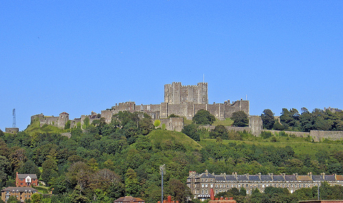
Dover Castle
Perched high on the White Cliffs, this is England’s
largest castle and often called the “Key to England” for its strategic
role guarding the shortest sea crossing to Europe. It’s a Grade I listed
fortress managed by English Heritage, with layers of history spanning
Roman times to the nuclear age.
In-depth history:
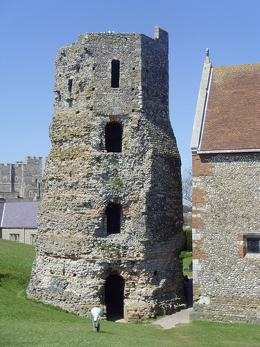
Roman era
(1st century AD): The site includes one of Britain’s oldest standing
structures—the Roman Pharos (lighthouse), built shortly after the
conquest. It’s the tallest surviving Roman building in England and was
later converted into a church bell tower (St. Mary in Castro).
Medieval period: William the Conqueror fortified it post-1066, but the
grand stone castle was built by Henry II in the 1180s (costing a
fortune). The massive Great Tower (keep) combined defense with palatial
living. It withstood sieges in 1216–17 (during the First Barons’ War
against King John) and later conflicts.
Later adaptations: Henry VIII
added artillery; Napoleonic Wars saw massive earthworks; 18th–19th
centuries turned it into a garrison fortress.
WWII: Secret tunnels
beneath housed the command center for Operation Dynamo (1940 Dunkirk
evacuation) and an underground hospital.
Key features and visitor
experience:
Great Tower and medieval interiors: Explore royal
apartments, banqueting halls, and defensive battlements.
Secret
Wartime Tunnels: Guided tours through the labyrinthine
passages—immersive and atmospheric, with recreated operations rooms.
Roman Pharos and church: Rare surviving Roman lighthouse.
Modern
additions: Interactive “Dover Castle Under Siege” exhibition on the 1216
siege, a new viewpoint (Spur), escape room (“The Bunker”), and kids’
siege play area.
Views: Sweeping panoramas of the harbor, cliffs, and
sea.
Open daily (typically 10am–5pm; check for last entry). Allow
several hours. It’s a full-day family-friendly site with events like
WWII weekends.
Western Heights Fortifications
These imposing
Napoleonic-era defenses (late 18th–19th century) sit on the hills
opposite Dover Castle. Built to repel French invasion, they include the
Drop Redoubt (a massive gun battery) and the unique Grand Shaft—a triple
spiral staircase cut 180 feet into the chalk to move troops quickly from
heights to the town below. Free to explore externally (guided tours
occasionally for interiors); great for walks with town and castle views.
Maison Dieu
Dover’s historic town hall (Grade I listed), founded
in 1203 as a pilgrim hospice for travelers to Canterbury’s shrine of
Thomas Becket. After a £10.5 million restoration, its Gothic interiors,
treasures, and 800-year history are now open daily to the public for the
first time—offering a glimpse into medieval hospitality and later civic
use.
Dover Museum and Bronze Age Boat
In Market Square, this
interactive museum traces Dover’s story from Neolithic times. Star
attraction: the 3,000-year-old Bronze Age Boat—the world’s oldest
surviving sea-going vessel, discovered nearby and preserved in a
dedicated gallery. Also covers the port’s history and local archaeology.
Visitor info center on-site.
Best Time to Visit
Late spring through early fall (May–September) is
ideal: milder weather, blooming flowers on the cliffs, longer days for
walks, and fewer rain interruptions. July and August are warmest and
busiest, with events like Dover Regatta or Pride. Shoulder seasons
(April–May or September–October) offer good weather with fewer crowds
and lower prices.
Winter brings quieter visits and lower costs but
shorter days, stronger winds, and more rain—still viable for indoor
sites like the castle tunnels. Dover's coastal climate means always
prepare for changeable weather: pack layers, waterproof jacket, and
sturdy walking shoes.
Practical Tips
Duration: 1 full day for
highlights (castle + cliffs); 2–3 days for relaxed exploration + nearby
towns.
Crowds: Peak summer and weekends busier at castle/cliffs.
Shoulder seasons or weekdays better.
Accessibility: Some cliff paths
and castle areas are steep/uneven. Check English Heritage/National Trust
sites for details; shuttles available in places.
Costs: Attractions
~£20–25 each; English Heritage or National Trust membership saves money
for multiple sites. Public transport or Oyster/contactless helpful.
Safety: Cliff edges can be unstable—stick to paths. Check tides for
beaches. Port area is busy with traffic/ferries.
What to Bring:
Binoculars for views/wildlife, picnic for cliffs, cash for some spots,
charged phone for navigation.
Food and Drink
Focus on seafood
(fresh from the Channel): fish & chips, moules marinières, prawns. Pub
classics like pies and ales at places like The White Horse (below the
castle). Turkish, Mexican, or café options too. Tea rooms (e.g., at
South Foreland Lighthouse) for scones and views. Marina Curve for street
food in summer.
Accommodation
Seafront/Marina: Dover Marina
Hotel (nice views, convenient).
Budget: Travelodge or chains near St
James.
Nearby: St Margaret's Bay or Deal for quieter, charming stays
(B&Bs, hotels, even yurts/chalets).
Prehistoric Dover (Stone Age to Iron Age)
The story begins long
before recorded history. Changing sea levels and erosion have destroyed
much of the earliest evidence, but late Stone Age (Neolithic) farmers
arrived around 6,000 years ago, crossing by boat with seeds and
domesticated animals to settle the River Dour valley. Flint implements
and pottery found in the Market Square mark it as one of Kent's major
early settlement areas.
In the Bronze Age (roughly 2500–800 BC),
Dover was a hub of early seafaring and trade. Britain's earliest known
shipwreck (c. 1100 BC) occurred offshore, scattering over 350 bronze
tools, weapons, and scrap metal (a Langdon Bay hoard). In 1992,
roadworks in the town center uncovered the Dover Boat—a large, seaworthy
wooden vessel dated to c. 1550 BC, one of the world's oldest surviving
sea-going boats, now displayed in Dover Museum. Over 45 Bronze Age
burial sites have been found locally, alongside evidence of trade with
the Continent and Ireland (including gold items).
Roman Period
(43 AD–5th Century)
Julius Caesar noted the white cliffs during his
55 BC expeditions, describing Dover as a natural landing point. After
the full Roman conquest in 43 AD, Portus Dubris (Dover) became the
closest and most important British port to the empire, linked by road
(Watling Street) to Canterbury. It served as one of three main Channel
ports (with Lympne and Richborough) for trade, troop movements, and the
Roman fleet (Classis Britannica).
The Romans built a large harbor
with breakwaters, two lighthouses (one surviving as the Pharos in Dover
Castle grounds, Britain's oldest standing building), and at least three
successive forts along the Dour estuary. A well-preserved Roman mansion
(the Painted House) and over 60 sites attest to a thriving town covering
at least five hectares. The Pharos lighthouse guided ships, and the site
supported naval operations until the Roman withdrawal around 410 AD.
Anglo-Saxon Period (5th–11th Centuries)
Germanic tribes (Jutes)
settled Kent after the Romans, and Dover (known as Dofras or Dubris)
grew into a major town in the Kingdom of Kent. Christianity arrived
early; a Saxon church of St. Mary in Castro was built around AD 1000
near the Roman Pharos (later incorporated into Dover Castle). By the
mid-10th century, Dover was prosperous, with fishing and maritime
expertise.
Around 1050, under Edward the Confessor, Dover joined the
Cinque Ports confederation (with Hastings, Romney, Hythe, and Sandwich;
later Rye and Winchelsea), providing ships and men for royal service in
exchange for privileges. It was a key Saxon borough by "prescription."
Norman Conquest and Medieval Period (1066–15th Century)
After the
Battle of Hastings in 1066, William the Conqueror seized Dover (then
partly burned) and established an early fortification, possibly around
the Saxon church. The town was rebuilt extensively. In the Domesday Book
(1086), Dover ranked first among Kent entries, valued highly as a
borough with self-governing burgesses.
The great medieval Dover
Castle—the "Key to England"—was constructed under Henry II (1179–1189)
by engineer Maurice. It featured an advanced design with an inner
bailey, massive great tower (combining defense and royal residence), and
outer works, making it one of Europe's most sophisticated fortresses.
Further enhancements under King John and Henry III followed the loss of
Normandy in 1204. The castle withstood major sieges in 1216–1217 during
the First Barons' War against Prince Louis of France (nearly captured
but held by Hubert de Burgh).
Dover thrived as a Cinque Port with
growing cross-Channel trade and pilgrim traffic (e.g., to Thomas
Becket's shrine in Canterbury). Religious sites proliferated: St. Martin
le Grand priory, churches like St. Mary the Virgin, and hospitals like
the Maison Dieu (founded 1203). A 1295 French raid burned much of the
town, but it recovered.
Tudor, Stuart, and 16th–18th Centuries
Tudor monarchs strengthened defenses against invasion threats. Henry
VIII improved the castle and built coastal bulwarks; Elizabeth I granted
a new charter and further fortifications. The 1580 Dover Straits
earthquake devastated the area. During the English Civil War, Dover
sided with the king but fell to Parliamentarians in 1648. Charles II
landed here in 1660 upon his Restoration.
The Napoleonic Wars (late
18th–early 19th centuries) turned Dover into a major garrison town.
Western Heights fortifications, the Grand Shaft (a 140-ft triple
staircase for rapid troop movement), and artillery batteries were added.
The castle was modernized with tunnels and casemates.
19th
Century: Growth as Port and Resort
Population boomed (600% growth
1801–1901) as the harbor was expanded with artificial moles. Railways
(from 1844) boosted passenger and freight traffic, including famous boat
trains. Dover developed as a seaside resort with piers, hotels, and
promenades.
20th Century: World Wars and Beyond
World War I
made Dover a naval base for the Dover Patrol; it faced early bombing and
shelling ("Fortress Dover").
In World War II, it earned the nickname
"Hellfire Corner" as Britain's frontline. Heavy bombing and shelling
from France (over 2,000 alerts, significant civilian deaths and damage)
occurred, but the castle's secret tunnels coordinated Operation Dynamo
(Dunkirk evacuation, 1940) and D-Day deceptions. The White Cliffs
symbolized resilience.
Post-war, the port was rebuilt. The castle
adapted for the Cold War as a potential nuclear Regional Seat of
Government (tunnels sealed until the 1980s).
Modern Dover (Late
20th Century–Present)
Today, Dover remains a major passenger ferry
port (busiest in the world for cross-Channel services to Calais and
Dunkirk), cruise terminal, and freight hub. Tourism thrives around the
White Cliffs (National Trust), Dover Castle (with its 2,000+ years of
history and secret tunnels), Roman Painted House, and museums.
Population is around 44,000 (2024), with ongoing regeneration (e.g.,
waterfront developments, high-speed rail links).
Location and Regional Context
Dover lies at approximately 51°07′46″N
1°18′32″E (OS grid reference TR315415), in the Dover District of Kent,
about 77 miles (125 km) southeast of London, southeast of Canterbury,
and east of Maidstone. It occupies the southeast corner of Britain, with
South Foreland—the nearest point on the English coast to the European
mainland—lying just east of the town. From there, Cap Gris Nez in France
is roughly 21 miles (34 km) away across the strait.
The strait itself
is 18–25 miles (30–40 km) wide and connects the English Channel to the
North Sea. Dover forms part of the broader geography of Kent, which is
shaped by the remnants of the Wealden dome—an ancient geological
structure eroded by the sea in its eastern section. The town sits where
the North Downs chalk ridge meets the coast, forming dramatic cliffs.
Much of the surrounding area, including Dover, is built on chalk, and
the region falls within the Kent Downs Area of Outstanding Natural
Beauty (AONB).
Topography and Landforms
The town's original
settlement developed in a sheltered valley carved by the River Dour,
which provided protection from prevailing south-westerly winds. This
valley is flanked by higher chalk uplands: the Western Heights to the
west and the prominent hill (around 375 ft / 114 m above sea level) to
the east where Dover Castle stands. The cliffs rise steeply to the sea's
edge on both sides of the town, severely limiting coastal expansion; as
a result, the town has grown inland up the river valley, incorporating
former villages like Buckland, Charlton, River, and Temple Ewell.
The
White Cliffs of Dover are the defining feature—stretching approximately
8 miles (13 km) along the coast on both sides of the town (roughly
between 51°06′N 1°14′E and 51°12′N 1°24′E). They reach heights of up to
350 ft (110 m) and are part of the North Downs formation. The cliffs
create a dramatic, sheer white face visible from the French coast on
clear days and mark one of the most iconic coastal landscapes in
Britain.
Geology and Formation
The White Cliffs consist
primarily of chalk from the Late Cretaceous period (about 100–66 million
years ago), formed from the remains of tiny marine algae called
coccolithophores that accumulated as white mud on the seafloor at depths
up to 500 m (1,600 ft). Layers of black flint (from silica-rich sponges
and plankton) create distinctive horizontal bands that match those on
the French side at Cap Gris Nez, evidencing a prehistoric land
connection.
The cliffs were later uplifted by the Alpine orogeny
(mountain-building event) during the Cenozoic era. The Strait of Dover
itself formed relatively recently in geological terms: until around
450,000–180,000 years ago, Britain was connected to Europe via the
Weald-Artois Anticline ridge. Catastrophic glacial lake outburst floods
(megafloods) breached this ridge, carving the strait. Final separation
occurred with rising sea levels at the end of the last Ice Age, around
8,000–6,000 years ago.
Ongoing coastal erosion (now 220–320 mm /
8.7–12.6 inches per year in recent centuries, accelerated by storms and
human activity) continues to shape the cliffs, with notable collapses
recorded in recent decades. The cliffs and surrounding chalk grasslands
are designated as a Site of Special Scientific Interest (SSSI) and
Special Area of Conservation (SAC).
Hydrology and Coastline
The River Dour is a short chalk stream (about 4 miles / 6.4 km long)
that rises at Watersend in Temple Ewell (fed by springs from the chalk
aquifer) and flows through the town to empty into the English Channel at
Wellington Dock in Dover Harbour. Historically, it created a wide
natural estuary that served as a natural harbor for Romans, Saxons, and
later traders, but longshore drift (coastal sediment movement) caused
significant silting.
This necessitated extensive artificial harbor
works, including breakwaters. Today, much of the modern Port of Dover
sits on reclaimed land, with the river largely culverted or channeled
through the urban area in its lower reaches. As a classic chalk stream,
the Dour supports high water quality, brown trout, and other aquatic
life, though it has faced historical pollution and modification.
The
coastline features shingle beaches at the base of the cliffs and the
busy harbor complex. Prevailing winds and tidal currents make the Strait
of Dover one of the world's busiest shipping lanes.
Climate
Dover has a typical oceanic climate (Köppen: Cfb)—mild year-round with
moderate rainfall and no extreme seasonal swings, influenced by its
coastal position. Average daily highs range from about 8°C (46°F) in
winter to 21°C (70°F) in summer; lows from 3.6°C (38.5°F) to 14.8°C
(58.6°F). Annual precipitation totals around 832 mm (32.8 inches),
spread fairly evenly but with slightly wetter autumn/winter months.
Record extremes include 37.4°C (99.3°F) in 2019 and –9.5°C (14.9°F) in
1972. Sunshine hours average about 1,770 per year.
The sheltered
valley location and proximity to the sea moderate temperatures, while
the cliffs and heights provide some wind protection inland.
Environmental and Human-Geography Notes
The cliffs support rich chalk
grassland ecosystems with wildflowers (e.g., early spider orchids, rock
samphire), butterflies (Adonis blue, chalkhill blue), and seabirds
(peregrine falcons, kittiwakes). Management includes grazing with Exmoor
ponies to preserve biodiversity.
Geographically, Dover's position has
profoundly shaped its history and economy: the natural harbor gap in the
cliffs, combined with proximity to Europe, made it a vital port (one of
the Cinque Ports historically) and defensive stronghold (Dover Castle
overlooks the town). The port now dominates the reclaimed waterfront,
while the town extends up the Dour valley.
Historical Roots and Heritage Culture
Dover's culture is inseparable
from its layered history, which begins in prehistoric times. Stone Age
settlers crossed a land bridge before the English Channel formed,
followed by Bronze Age traders evidenced by the remarkable
3,500-year-old Dover Boat—the world's oldest known seagoing vessel,
discovered in 1992 and now the star exhibit at Dover Museum.
Roman
occupation established Portus Dubris as a vital harbor and naval base,
leaving behind the tallest surviving Roman lighthouse in Britain (within
Dover Castle) and the exquisite Roman Painted House with its preserved
frescoes. Norman conquests, medieval Cinque Ports status (one of five
confederated ports providing ships for the Crown), and later defenses
against French and Napoleonic threats reinforced its strategic identity.
The White Cliffs themselves—dramatic chalk formations visible from the
sea—have become a potent national symbol of British steadfastness,
immortalized in Vera Lynn's WWII song "(There'll Be Bluebirds Over) The
White Cliffs of Dover," literature (Matthew Arnold's "Dover Beach"), and
folklore. Dover Castle, perched atop them, dominates the skyline and
encapsulates 2,000 years of history, from Roman origins through medieval
sieges (notably 1216) to its pivotal role in WWII's Operation Dynamo
(Dunkirk evacuation), coordinated from the Secret Wartime Tunnels.
Arts, Entertainment, and Community Spaces
Dover supports a modest
but active cultural infrastructure centered on heritage and community.
The Discovery Centre in Market Square houses the main Dover Museum, a
cinema (Silver Screen), the Roundhouse Community Theatre, and adult
education facilities. Other venues include the White Cliffs Theatre at
Astor College, community theater at local schools, and Dover Community
Radio (DCRFM), which broadcasts local music, news, and programs.
The
town features in broader arts through literary and musical references,
and recent initiatives (like community arts projects) signal a
revitalizing scene amid coastal regeneration. Cinemas and live venues
complement the historical focus.
Festivals and Traditions
Annual events celebrate Dover's diversity, history, and seaside
character:
Dover Multicultural Festival (held in June at Pencester
Gardens): Launched in 2017 by the Samphire Project, this free family
event draws hundreds to showcase music, dance, food, art, and
performances from local schools and migrant communities. It explicitly
bridges cultures—featuring African drumming, Chinese dance,
international stalls, and traditional British elements—highlighting the
town's evolving diversity and positive integration.
Dover
Regatta/Harbour Festival: A summer highlight with waterside games, live
music, local food/drink stalls, and family activities, emphasizing the
town's maritime roots.
Heritage Open Days and historical festivals:
Dover participates enthusiastically in England's largest such event,
with free access to sites and volunteer-led activities.
Other
seasonal events include lantern parades, Easter celebrations, and
coastal community gatherings.
These foster a welcoming, inclusive
atmosphere rooted in the port's role as a cultural crossroads.
Cuisine and Food Culture
Dover's food scene reflects its coastal
location and Kentish ("Garden of England") produce. Traditional English
fare dominates: fresh seafood (notably fish and chips, with the town
lending its name to Dover sole), hearty pub roasts, and local
ales/ciders from Kent's hop fields and orchards.
Iconic spots
include:
The White Horse (Dover's oldest pub, dating to 1365), known
for award-winning cask ales, beer-battered fish, and Sunday roasts in a
cozy historic setting.
Cafés and restaurants serving full English
breakfasts, Italian-influenced dishes with local fish/meat, and sea-view
dining.
Modern eateries incorporate seasonal, locally sourced
ingredients, with markets and food festivals celebrating Kentish
produce. International flavors appear via the multicultural community
and port influences.
Sports, Recreation, and Daily Life
Outdoor and maritime activities define leisure: Dover Rowing Club
(Britain's oldest coastal rowing club), Dover Athletic F.C. (football in
the National League South), rugby, netball, swimming, kayaking,
paddle-boarding, and sea fishing. The English Channel swim draws global
attention.
Community life centers on pubs, the leisure centre, and
green spaces like the chalk lands owned by the Town Council. Education
includes historic institutions like Dover College, and the town
maintains a practical, resilient character tied to port employment and
tourism.