Location: Nr Westleton Map
Tel. 01728 648501
Open: dawn- dusk
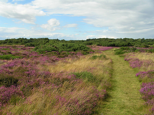
Dunwich Heath, located on the Suffolk coast in eastern England, is a captivating expanse of coastal lowland heath just south of the village of Dunwich. Managed by the National Trust since 1968, it forms part of the Suffolk Coast and Heaths Area of Outstanding Natural Beauty (AONB), a landscape celebrated for its rare habitats and unspoiled tranquility. Covering approximately 250 acres, plus a mile of shingle beach, Dunwich Heath is a haven for wildlife, a canvas of vibrant flora, and a site steeped in history, offering visitors a serene yet dramatic encounter with nature. Its proximity to the RSPB’s Minsmere reserve and its role as a Site of Special Scientific Interest (SSSI) underscore its ecological significance.
Position in the coastal landscape
Dunwich Heath occupies the
seaward edge of the Sandlings strip - the belt of infertile sands and
gravels that once ran from Lowestoft toward Ipswich. Most of that belt
was ploughed, planted with conifers or built on. What remains here is a
gently rolling plateau that drops east to low cliffs and a shingle
beach, and south into the wetland of the Minsmere valley. To the west
and north it grades into Dunwich Forest and the more inland heaths
around Westleton. Sizewell B’s dome is the usual southern landmark on
the horizon.
The village of Dunwich itself sits on a shrinking
peninsula of slightly higher ground between the sea and the Dunwich
River / Dingle Marshes system to the north. Historic maps show that
peninsula was once far larger; storms from the late 13th century onward
removed the medieval port and pushed the river mouth north toward
Walberswick. The heath is the surviving high, dry ground immediately
south of that lost town.
Topography
This is not dramatic hill
country. Elevations are low - typically on the order of 15–30 m above
sea level on the plateau, with cliffs commonly described around 17–20 m
and locally a little higher where the Westleton Beds thicken. Slopes are
gentle and sandy. Paths feel almost level until you reach the cliff
edge, then the ground falls quickly to the beach. Sandy soils, tree
roots and uneven slopes make the surface soft and easily eroded
underfoot.
Drainage is simple. Rain soaks into the sand or runs east
toward the sea and south into Docwra’s Ditch, a linear wetland cut along
the southern boundary (originally an army ditch, later a conservation
feature). That ditch is the hinge between dry heath and the reedbeds and
scrapes of Minsmere. There is no significant river on the heath itself.
Geology and soils
The cliffs are a Regionally Important
Geological Site. They expose the Norwich Crag Formation - late Pliocene
to early Pleistocene marine sands and gravels laid down when a shallow
sea stood over this part of East Anglia about 2 million years ago. The
most distinctive layers are the Westleton Beds: thick, well-sorted,
well-rounded flint cobbles in a clast-supported fabric. In the northern
half of the exposure they fill a wide (about 600 m), shallow trough cut
into underlying Crag sands and running at right angles to the present
shoreline. That trough is interpreted as a channel between barrier
islands of the Crag sea.
Above the Crag sit unconsolidated Quaternary
sands and thin soils. The working surface of the heath is mainly sand -
acidic, free-draining, nutrient-poor podzols. Those soils are why
heather and gorse dominate and why agriculture never fully absorbed this
patch. Where the sand gives way to slightly richer ground, birch, oak,
pine and a few other trees take hold. Iron pans can form in the profile;
the weathered Crag often shows yellowish to reddish-brown tones.
Coast, cliffs and beach
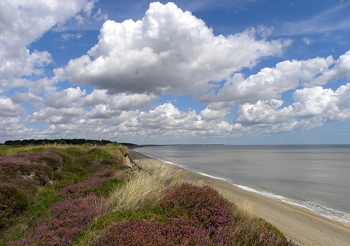
The eastern edge is a live coast. A shingle
beach (sand overlain by pebbles) fronts the cliffs. The beach is
relatively wide and has, in recent decades, helped armour the cliff toe.
National Trust rangers note that storm damage has so far been worse at
the cliff top (heavy rain washing the crest) than at the base, because
the shingle still buffers wave attack and vegetation binds the face.
That protection is not guaranteed. If storms strip the beach, the soft
Crag and sand cliffs would retreat quickly. Historic rates for the wider
Dunwich frontage have averaged around 1 m per year over centuries, with
faster pulses in the medieval and early modern periods.
The beach
itself carries specialist plants such as sea pea. The sandy cliff face
is nesting ground for sand martins and hunting ground for warmth-loving
insects (antlion, spider wasp). From the cliff path the view is a long,
low arc of Suffolk bay: Dunwich village and Dingle to the north,
Minsmere levels and Sizewell to the south.
Habitat mosaic (the
living geography)
Geography here is inseparable from vegetation,
because the landform is low-relief and the soils dictate almost
everything.
Open heath - the core. Common heather (ling), bell
heather and cross-leaved heath, with European and western gorse.
Flowering is typically June–September, with bell and cross-leaved
peaking late July and ling in early August. Management is by cutting and
scraping, not burning, to keep a mosaic of ages and to avoid
catastrophic fire. That mosaic is what Dartford warbler, stonechat,
nightjar, woodlark and silver-studded blue need.
Acid grassland -
especially the restored Mount Pleasant Fields, winter-grazed by hardy
sheep (Hebridean, Herdwick, Manx Loaghtan, Whitefaced Woodland).
Woodland and scrub - pockets of silver birch and pine on the heath; oak,
ash, sycamore and chestnut where soils are less sandy. Birch is kept in
check because it would close the heath.
Wetland - Docwra’s Ditch and
its reed fringe: amphibians, water vole, otter, reed birds.
Beach and
cliff - shingle vegetation, sand-martin banks, insect-rich bare sand.
Lowland heath of this type has declined by about 92 percent in England
over the last 120 years. Dunwich is valuable precisely because it is
still a continuous coastal tract rather than an inland fragment.
Climate and process
The site is dry, windy and maritime. Summers that
are hotter and drier stress young heather and raise fire risk (already
visible in the 2022 drought die-off and then the 2026 blaze). Warmer
winters allow heather beetle and some fungi and burrowing insects to
persist. Stronger storms threaten the cliff-beach balance. The geography
is therefore not static: it is a sand-and-gravel platform being nibbled
from the east, slowly invaded by trees from the west, and periodically
reset by fire.
Landscape and deep time
The heath sits on acid, sandy soils laid
down as marine sediments and later reworked by ice, wind and water.
That geology produced the Suffolk Sandlings, a band of heather,
gorse and acid grassland that once ran almost continuously along the
coast. Over the last 120 years about 92 percent of England’s lowland
heath has been lost to ploughing, planting and building; Dunwich
Heath is one of the last substantial fragments. Grazing by sheep and
rabbits kept woodland from invading for centuries and created the
open habitat that conservationists now work to restore.
The
cliffs themselves are a regionally important geological site. They
recede under storm surge and rising relative sea level. Historically
the shoreline here has moved inland by kilometres; in the Roman
period it is estimated to have lain well over a mile further out.
The same process that created the heath’s drama is still eating it.
Prehistoric and Roman traces
Evidence on the heath itself is
thin, but the parish and cliffs have produced a late Acheulean
hand-axe (found eroding from the cliff in 1956) and Neolithic tools.
The wider Dunwich landscape was used as hunting and early settlement
ground. Roman activity is attested by finds and by later antiquarian
claims of a coastal fort; a Romano-British community is often
assumed at or near the later town, though the precise site is now
offshore.
Anglo-Saxon capital and the see of Dommoc
In the
seventh century Dunwich became the political and religious heart of
the East Anglian kingdom. King Sigeberht made it his capital. Before
650 a bishopric was founded here; St Felix of Burgundy, first bishop
of the East Angles, is closely associated with the place. Many
scholars identify Dunwich with Dommoc, the early episcopal seat
described by Bede, though Walton Castle near Felixstowe is a rival
candidate. By the late Saxon period Dunwich was a substantial
trading settlement with a harbour at the mouth of the Dunwich River.
Medieval boom: one of England’s great ports
The Domesday Book
of 1086 already records a large town: three churches, hundreds of
burgesses, and a population commonly estimated around 3,000. Between
1066 and 1086 more than half the taxable farmland had already been
lost to the sea - the first written warning of what was coming.
By the twelfth and thirteenth centuries Dunwich was among the ten
largest towns in England and, in area, comparable to the City of
London. Peak population estimates range from 5,000 to as high as
8,000-10,000. It had a mint, a market, a guildhall, shipyards, and a
fishing and merchant fleet that traded wine, wool, stone, salt and
fish with the Low Countries, France, Germany, Spain and Iceland. It
built warships for the Crown and, in 1173, held off an attack by the
Earl of Leicester. King John granted it a borough charter. At its
height the town contained around eight parish churches plus chapels,
two friaries (Greyfriars and Blackfriars), hospitals including a
leper hospital (St James) and the Maison Dieu, and a Knights Templar
house. Greyfriars was founded in the 1250s on low ground nearer the
sea.
The heath and common to the south of the built-up town were
part of this economy: open grazing land for large flocks that kept
the Sandlings open.
Storms, silt and the drowning of the town
Prosperity depended on an open harbour. Coastal processes and storms
first silted the river mouth and then destroyed the low-lying
quarters.
Key blows:
1286-87: major storm surges wrecked
buildings and began blocking the haven.
1328: a storm built a
sand-and-gravel spit that closed the harbour; the river mouth later
shifted north toward Walberswick.
1347: another storm destroyed
some 400 houses in the lower town.
Later fourteenth-century
storms took churches of St Michael, St Bartholomew, St Leonard, St
Martin and St Nicholas; Blackfriars was lost in 1384.
Further
damage in 1560, 1570 (Candlemas storm) and 1740.
By 1602 the
town was reduced to about a quarter of its former size. All Saints
church, the last major medieval church on land, stood on the cliff
until its tower finally fell in 1919. Underwater survey since the
2000s has mapped streets, churches (St Peter, All Saints, St
Nicholas, St Katherine’s chapel), Blackfriars, possible town-hall
masonry and harbour works across roughly 1.8 km² of seabed - the
largest known underwater medieval town site in the world. Local
legend still speaks of bells ringing under the waves.
What
remains on land is a tiny village, Greyfriars (rebuilt further
inland after the 1286 storm and now itself close to the cliff), the
leper-hospital chapel, and the heath.
Dunwich kept two Members of
Parliament until the Reform Act of 1832 as a notorious rotten
borough, even when only a handful of residents remained. The
corporation was abolished in 1886.
Common, smugglers and
coastguards
After the port died, the heath continued as common
and sheep-walk. In the eighteenth century the isolated cliffs and
beach became a smuggling coast. Gangs ran brandy and tobacco; the
Hadleigh gang and figures such as John Harvey appear in local
research. The Preventive Service (later Coastguard) was stationed
here to stop them. The present Coastguard Cottages date from this
nineteenth-century watch. One resident, Richard Clark (1850s), was a
Quaker who refused Crimean War service, was imprisoned on a hulk,
and became an early test case for conscientious objection after John
Bright raised his case in Parliament.
In the First World War the
East Coast War Channel had to be kept open; local trawlermen swept
mines while the cliffs remained a lookout.
Second World War:
radar, guns and D-Day rehearsal
Dunwich Heath became one of the
most heavily defended stretches of the Suffolk coast.
Chain Home
Low radar went operational on 1 January 1940 (initially two 20-foot
gantries). A replacement station opened in February 1941; by spring
1943 Dunwich was one of five CHL “tower” stations with a 185-foot
mast, chosen because low-flying raiders were common here. Almost
nothing survives above ground; much has fallen into the sea.
Emergency Coastal Defence Battery (May 1941): two 6-inch naval guns
in concrete houses on the cliff, operational for nearly two years
before the guns moved to Landguard Fort. The observation post was
disguised by being built onto the end of the Coastguard Cottages
(today’s lookout). A loopholed generator building also survives.
Infantry positions, pillboxes, barbed wire, anti-tank obstacles, a
surviving spigot-mortar pedestal, and anti-glider ditches covered
the heath.
In 1944 a “Diver” anti-aircraft battery was added to
engage V-1 flying bombs launched from aircraft over the North Sea.
The wider Dunwich training area stretched miles inland. In 1943
Operation Kruschen built a full-scale mock German “hedgehog” -
trenches, minefields, pillboxes, anti-tank ditches and flame-thrower
practice - to test methods of breaking the Atlantic Wall before
D-Day. Live firing was routine. After the war most concrete was
cleared for hardcore and, after a 1960s heath fire set off buried
munitions, systematic bomb disposal followed. Unexploded ordnance
from Kruschen still lies in the ground.
National Trust and
conservation
After the war the Dunwich Town Trust owned the land.
Unregulated camping was damaging the heath; new caravan-site laws
would have forced facilities the Trust did not want to build. In
1968, with a £12,000 gift from H.J. Heinz as part of Enterprise
Neptune, about 250 acres plus a mile of shingle beach became the
first National Trust property in Suffolk. A ceremony on 27 March
1968 marked the handover. Further land (Mount Pleasant Farm, 79
acres in 2002, funded in part by a Pizza Express “Neptune” pizza
campaign, plus another parcel in 2015) extended the reserve and
allowed arable to be returned to acid grassland and heather.
Management since then has been active: cutting, controlled grazing
(Hebridean, Herdwick, Manx Loaghtan and other sheep), and habitat
restoration. Dartford warblers returned after a 60-year absence and
now breed in numbers; stone-curlews nested successfully from 2017;
nightjar, woodlark, adders, antlions and silver-studded blues are
among the specialist species. The site lies within the
Minsmere-Walberswick Heaths and Marshes SSSI, SAC and SPA and the
Suffolk Coast and Heaths AONB.
Recent years
Heather
suffered drought die-back in 2022. On 29 July 2026 a large wildfire,
driven by heat, drought and wind, burned an area on the order of 150
hectares (roughly 200 football pitches) across Dunwich Heath and
neighbouring Minsmere. The site remains closed. The fire exposed
unstable ground and unexploded Second World War munitions from
Operation Kruschen; recovery and safety work continues. A National
Trust appeal for restoration has already raised substantial funds.
Coastal erosion of about a metre a year in places, and the long-term
unsustainability of hard defence, remain the background condition of
the whole coast.
What the place is
Dunwich Heath is a rare surviving patch of
lowland coastal heath on the Suffolk coast, inside the Suffolk Coast
and Heaths AONB and designated SSSI. Habitats include heather and
gorse heath, acid grassland, woodland, wetland (Docwra’s Ditch),
sandy cliffs and a shingle beach. It is one of the better places in
East Anglia for specialist heathland birds. The National Trust has
managed it since 1968 (Enterprise Neptune purchase, later extensions
including land funded by a Pizza Express “Neptune” pizza campaign).
The classic view is rolling purple heather (peak July–September)
dropping toward the North Sea, with Coastguard Cottages as the
visitor hub.
Getting there and parking (normal operations)
Address: Coastguard Cottages, Minsmere Road, Dunwich, Suffolk IP17
3DJ.
Signposted from the A12. From the Westleton–Dunwich road
turn onto Minsmere Road about 1 mile before the village and continue
1 mile. Nearest station is Darsham (about 6 miles);
demand-responsive bus exists but must be booked. The Suffolk Coast
Path and Sandlings Walk pass through when open.
Car park is
usually 9am–4pm and locked outside those hours. Heath pedestrian
access is typically dawn to dusk. Non-members pay a parking fee
(recently around £6 for a car with Gift Aid option; motorcycles
less; motorhomes more). National Trust members and Blue Badge
holders park free. Collect tickets at Visitor Welcome. Coaches need
advance booking.
Facilities
Coastguard Cottages hold the
tea-room (light meals, cakes, drinks; dogs at marked tables), a
small second-hand bookshop, and a lookout with sea views. Heath Barn
has interpretation. Toilets (including accessible via Radar key,
baby change) sit by the car park and café. Picnic tables are near
the cottages; you can also picnic on the grass or beach. Small play
area. Ice-cream kiosk in summer. Visitor Welcome hut for maps,
tracker packs, and advice. Powered mobility vehicles (Trampers) can
be booked when the hut is open.
Tea-room hours have often been
10am–3pm; confirm on the day.
Walks and what to look for
Four colour-coded waymarked routes (roughly 1–3 miles) plus the
dedicated purple “Woof Walk.” Terrain mixes sand, gravel, mud,
slopes and some roots; sturdy shoes help.
Pink route: main
heathland circuit. Best for Dartford warbler, stonechat, skylark.
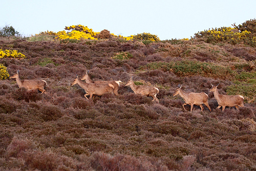
Orange: woodland and some heath; good for woodland birds and deer in
autumn/winter.
Grey: wetland and Docwra’s Ditch for reedbirds and
waders; benches for binocular work.
Cliff-top and beach:
seabirds, shingle, views. Do not climb crumbling cliffs; use
official access.
Bring binoculars. Dartford warblers returned
after a long absence and have been a signature species; nightjar,
woodlark and (more recently) stone curlew have also nested. Adders
and ticks are present. Deer are easier in cooler months; stags
during the autumn rut. Three types of heather plus gorse (coconut
scent when in flower).
Family extras when running: free tracker
packs, geo-caches, den-building, ranger walks (bookable). History
trail covers smugglers, coastguards and WWII.
Dogs, seasons
and practical tips
Three-pawprint rating. 1 March–31 August: dogs
on a short lead and on paths on the heath to protect ground-nesting
birds; off-lead allowed on the beach (do not chase birds or seals)
and on the Woof Walk. Rest of year: off-lead under close control.
Dogs welcome in the tea-room at marked tables. Water bowls, spare
leads and poo bags usually available. Check pets for ticks.
Best
quieter times: early morning or late afternoon, weekdays. Busiest
11am–1pm. Heather colour is the visual highlight in late summer.
Exposed site: wind and sudden weather changes are normal; layers and
a windproof are useful. Little shade on the open heath or beach.
Stay on paths. Do not drop litter (fire risk on dry heath). After
any fire event, follow all signage even more strictly.
History on the heath itself
The cottages were a 19th-century
coastguard station after earlier smuggling (brandy, tobacco). One
resident, Richard Clark, became an early conscientious objector
during the Crimean War. In WWII the area was heavily defended and
used for Operation Kruschen, a large 1943 D-Day rehearsal that built
mock German defences, minefields and pillboxes. Unexploded ordnance
from that period is one reason the current closure is cautious.
“Turbulence to Tranquility” interpretation in Heath Barn and on
trails covers this story.
The lost city next door (open now)
Modern Dunwich is a tiny village. In the Middle Ages it was a major
East Anglian port with churches, friaries, a mint and thousands of
inhabitants; storms from 1286 onward and relentless coastal erosion
swallowed most of it. All Saints church finally went over the cliff
in the early 20th century. Local legend still talks of bells ringing
under the sea. Underwater survey has mapped streets, churches and
walls a short distance offshore.
Visit while the heath is closed:
Dunwich Museum (St James Street): free/donation, typically
11:30am–4:30pm April–October, wheelchair accessible with lift,
dog-friendly. Maps, artefacts and the “lost city” story.
Greyfriars (Franciscan friary ruins, Grade II / scheduled): free to
walk the walls and precinct on the clifftop. Last substantial
medieval building still on land.
Village shingle beach and Flora
Tea Rooms (classic fish and chips, breakfast, cakes; large free car
park with donation requested; seasonal hours, often 9:30am until
mid-afternoon).
The Ship at Dunwich: pub with local food and ale,
dog-friendly, marsh and sea views.
Leper hospital chapel remains
in the churchyard; St James Church.
A 7-mile circular
avoiding the closed heath has been promoted from The Ship toward
Walberswick and back along the beach.
RSPB Minsmere is
immediately south and reopened after the fire (report to the visitor
hub; some zones still closed). It remains one of the UK’s premier
bird reserves.
When the National Trust eventually reopens Dunwich
Heath, combine it with the village in one day: park at the heath for
the trails and tea-room, then walk or drive the short distance into
Dunwich for ruins, museum and fish and chips. Always confirm current
access on the National Trust Dunwich Heath page and Suffolk Coast
Path updates before you set out.