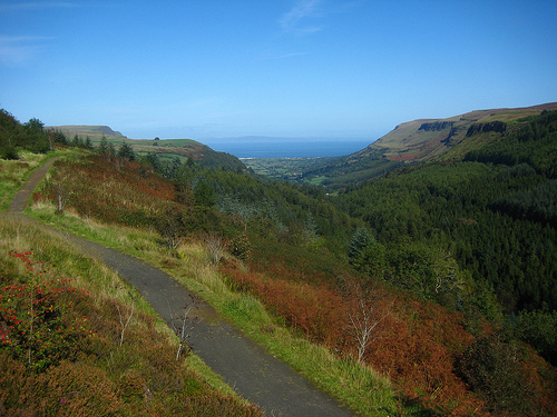
Location: County Antrim Map
Area: 2928 acres
Tel. 028 2955 6014
Open: daily
Official site
Glenariff Forest Park, nestled in the heart of the Glens of Antrim in County Antrim, Northern Ireland, is one of the region’s most breathtaking natural attractions. Often called the “Queen of the Glens,” it spans approximately 1,185 hectares (2,928 acres) within the Glenariff valley, renowned for its dramatic waterfalls, lush woodlands, and sweeping views of the Antrim Coast. Managed by the Northern Ireland Forest Service, the park is a haven for hikers, nature enthusiasts, and those seeking to experience the rugged beauty of the Glens. Its rich ecology, cultural resonance, and historical context make it a standout destination, complementing your earlier queries about Northern Ireland’s geography, history, and landmarks like Carrickfergus and Dunluce Castles.
Glenariff Forest Park occupies the upper reaches of the Glenariff
valley, one of the nine Glens of Antrim, a region shaped by glacial
activity and geological upheaval. The park’s terrain is a mix of
steep slopes, river gorges, and open moorland, offering a microcosm
of Northern Ireland’s diverse landscapes.
Topography: The
park centers on the Glenariff River, which carves a deep, V-shaped
valley through basalt and chalk bedrock. Elevations range from 100
meters (328 feet) at the valley floor to over 300 meters (984 feet)
on surrounding hills like Trostan (551 meters/1,808 feet), the
highest peak in Antrim, just outside the park. The valley’s steep
sides, formed by Ice Age glaciers, create a dramatic setting, with
waterfalls tumbling over basalt cliffs. The park’s northern edge
opens toward Red Bay and the Irish Sea, visible from higher trails.
Water Features: The Glenariff River is the park’s lifeblood, feeding
a series of waterfalls that are its hallmark. The most famous are
Ess-na-Larach and Ess-na-Crub, part of the Waterfall Walk, where
water cascades over stepped basalt into fern-lined pools. Smaller
streams, like the Inver River, join the Glenariff, creating a
network of rivulets that sparkle in sunlight. These waters flow
north to the sea at Glenariff Bay, 5 miles (8 km) away.
Geology:
The park sits on the Antrim Plateau, dominated by basalt from
volcanic eruptions 60 million years ago, overlaid in places by
softer chalk and limestone. Glacial erosion sculpted the glens,
leaving U-shaped valleys and moraines. Exposed basalt cliffs, like
those near the waterfalls, reveal hexagonal columns akin to the
Giant’s Causeway, 25 miles (40 km) north. The valley’s fertile soils
support dense vegetation, contrasting with the moorland above.
Climate: Glenariff enjoys a temperate maritime climate, with mild
winters (5–8°C/41–46°F) and cool summers (15–20°C/59–68°F). Annual
rainfall averages 1,200–1,600 mm (47–63 inches), heaviest on higher
slopes, feeding the park’s lush greenery and waterfalls. Fog and
mist often cloak the valley, adding mystique, while Atlantic breezes
keep air fresh.
Glenariff Forest Park is a biodiversity hotspot, blending native
woodlands with managed plantations and supporting a range of flora
and fauna.
Flora: The park’s lower slopes are cloaked in
mixed woodland, with native species like oak (Quercus robur), ash
(Fraxinus excelsior), and hazel (Corylus avellana) mingling with
planted conifers—Sitka spruce, Norway spruce, and Scots
pine—introduced in the 1930s for timber. Ferns, mosses, and
wildflowers (e.g., bluebells, primroses) carpet the forest floor,
especially along riverbanks. Higher up, heather (Calluna vulgaris)
and gorse dominate moorland, blooming purple and yellow in late
summer. Rare plants, like the Irish lady’s-tresses orchid, thrive in
damp glades.
Fauna: The park teems with wildlife. Red squirrels,
a conservation priority, dart through trees, protected from invasive
grey squirrels by ongoing efforts. Birds include buzzards, peregrine
falcons, and dippers, the latter skimming the river for insects.
Smaller species, like robins and goldcrests, fill the air with song.
Mammals include badgers, foxes, and occasional pine martens, while
amphibians like the common frog breed in streams.
Insects—butterflies (peacock, red admiral), dragonflies—add
vibrancy. The river supports brown trout and salmon, drawing anglers
with permits.
Conservation: Managed by the Forest Service since
its establishment in 1935, Glenariff balances recreation, timber
production, and ecology. Initiatives include replanting native
trees, controlling invasive rhododendron, and monitoring red
squirrels via camera traps. The park’s designation within the Antrim
Coast and Glens Area of Outstanding Natural Beauty (AONB) ensures
strict protections, with trails designed to minimize erosion.
Climate change poses risks—wetter winters threaten landslides, while
warmer summers stress amphibians—prompting adaptive forestry
practices.
Ecosystem Role: Glenariff’s woodlands sequester
carbon, aiding Northern Ireland’s net-zero goals. Its rivers feed
the regional watershed, supporting agriculture in the lower glens.
The park’s trails educate visitors, fostering eco-awareness in a
region historically tied to farming and industry.
Glenariff’s history reflects the Glens of Antrim’s evolution, from
ancient clans to modern tourism.
Prehistoric and Celtic
Roots: The glens were inhabited by Neolithic farmers (c. 4000 BC),
with megalithic tombs like Ossian’s Grave (nearby in Glenaan)
hinting at early settlement. Iron Age Celts left hillforts, and
Glenariff’s name—Gleann Airbh, meaning “glen of the plough” or
“productive glen” in Irish—suggests agricultural use. Local legend
ties the park to Finn McCool, the mythical giant said to have shaped
Antrim’s landscapes.
Medieval and Gaelic Era: By the Middle Ages,
the glens were controlled by Gaelic clans, notably the MacDonnells,
who arrived from Scotland in the 14th century. Glenariff, less
fortified than coastal Dunluce Castle, was a hinterland for hunting
and grazing. The MacDonnells resisted English conquest during the
16th-century Nine Years’ War, using the glens’ rugged terrain for
guerrilla tactics.
Plantation and Aftermath (17th–19th
Centuries): The 1609 Plantation of Ulster brought Scottish and
English settlers to Antrim, displacing many Gaelic families.
Glenariff’s lower valley saw small-scale farming, with clachans
(hamlet clusters) dotting the landscape. The 19th century brought
hardship; the Great Famine (1845–1852) hit the glens hard, spurring
emigration to America and Scotland. Remnant stone walls and
abandoned cottages in the park recall this era.
Modern
Development: In the 1930s, the Northern Ireland government
afforested Glenariff to create jobs and timber during economic
slump. The Forest Service built trails and a tea house, opening the
park to visitors in 1935. Post-World War II tourism boomed, with
Glenariff marketed as a scenic escape, rivaling the Giant’s
Causeway. Recent decades have emphasized conservation, with EU
funding post-1998 Good Friday Agreement supporting rural
regeneration.
Glenariff Forest Park is woven into Northern Ireland’s cultural
fabric, reflecting both shared heritage and local pride.
Gaelic and Ulster Scots Identity: The park’s Irish name and folklore
resonate with nationalist communities, who see the glens as a cradle
of Gaelic culture. Storytelling events, like those at the nearby
Glens Storytelling Festival, draw on tales of Finn McCool or
banshees haunting the waterfalls. For Ulster Scots, descendants of
Scottish planters, Glenariff evokes their rural roots, with
Presbyterian churches in nearby Waterfoot tying the valley to their
history.
Artistic Inspiration: The park’s beauty has inspired
painters, poets, and musicians. 19th-century artist Andrew Nicholl
sketched its waterfalls, while modern photographers capture its
misty trails. Folk songs, like “The Maid of Glenariff,” celebrate
the valley’s romance. The park’s serenity contrasts with the
Troubles’ urban strife, making it a symbol of peace for all
communities.
Tourism and Community: Glenariff anchors the Glens
of Antrim’s tourism economy, drawing 100,000+ visitors yearly. Local
businesses—B&Bs in Cargan, pubs in Waterfoot—thrive on hikers and
day-trippers. The annual Glenarm Castle Tulip Festival (nearby) and
Heart of the Glens Festival in Cushendall tie the park to regional
pride, blending music, sport, and crafts.
Cross-Community Role:
Unlike contested sites (e.g., Belfast murals), Glenariff is a
neutral space, welcoming unionists, nationalists, and visitors
alike. Its trails hosted peace-building walks during the Troubles,
and today, schools from across divides visit for outdoor education.
Glenariff Forest Park offers a range of trails, facilities, and
activities, catering to casual strollers and avid adventurers.
Access: Located off the A43 (Ballymena–Waterfoot road), the park
is 8 miles (13 km) from Cushendall and 40 miles (64 km) from
Belfast, a 1-hour drive via the M2 and A26. Signage at Glenariff
Road leads to the main entrance. Public transport is limited—buses
to Waterfoot (Translink 150) require a 2-mile walk—so driving is
best. Parking costs £5 (card payments preferred).
Visitor
Facilities: The park’s hub is the Visitor Centre, with a café
(serving Ulster fries, scones), gift shop (local crafts, maps), and
toilets. Picnic areas and a caravan site (open April–October,
£20/night) cater to families. Rangers offer guided walks in summer,
and info boards detail trails and wildlife. Wi-Fi is spotty, but a
payphone is available.
Trails:
Waterfall Walk (3 miles/4.8 km,
moderate, 1.5 hours): The park’s highlight, this loop descends
wooden boardwalks and steps to Ess-na-Larach and Ess-na-Crub
waterfalls. Ferns, mossy rocks, and river views create a fairy-tale
vibe. Slippery after rain; good shoes essential.
Scenic Trail
(5.6 miles/9 km, strenuous, 3 hours): A circular route climbing to
viewpoints over Red Bay and the Mull of Kintyre (Scotland, 25 miles
away). Heather moorland and forest mix; includes steep sections.
Binoculars recommended for spotting falcons.
Viewpoint Trail (0.6
miles/1 km, easy, 30 minutes): A short path to a ridge overlooking
the valley, ideal for families or those with limited mobility.
Benches offer rest stops.
Rainbow Trail (0.5 miles/0.8 km, easy,
20 minutes): A flat loop near the Visitor Centre,
wheelchair-accessible, with river views and picnic spots.
Activities: Hiking dominates, but birdwatching (guided tours, £10)
and photography are popular—the waterfalls’ mist creates rainbow
effects at midday. Mountain biking is allowed on designated paths
(permits £5). Fishing (trout, salmon) requires a license from the
Visitor Centre (£20/day). Dogs are welcome but must be leashed near
wildlife zones.
Preparation: Bring waterproofs, hiking boots, and
water; trails get muddy, and weather shifts fast. Mobile signal
fades on upper paths—download maps (Outdooractive app advised).
Midges bite in summer; repellent helps. Check nidirect.gov.uk for
trail closures post-storms.
Hours and Costs: Open 10 a.m.–dusk
daily (seasonal, ~4 p.m. winter, 8 p.m. summer). Entry is free
beyond parking; guided walks £5–10. Café hours: 10 a.m.–4 p.m.,
extended to 6 p.m. July–August.
Managing Glenariff involves balancing ecology, tourism, and
community needs.
Erosion: Heavy footfall (300 visitors/day on
Waterfall Walk) erodes paths, especially post-rain. The Forest
Service rebuilds boardwalks with recycled plastic, costing £50,000
yearly, funded by parking fees and grants.
Storms and Climate:
Winter gales (e.g., Storm Arwen, 2021) fell 10% of conifers,
requiring replanting with climate-resilient oaks. Wetter winters
increase landslides, closing trails like Scenic Trail for weeks
(last in 2023). Rangers monitor via drones.
Invasive Species:
Rhododendron and grey squirrels threaten native flora and red
squirrels. Removal programs (£20,000/year) and squirrel feeders
laced with contraceptives aim to restore balance.
Overcrowding:
Summer peaks strain parking (200 spaces), with illegal roadside
parking fined £60. A proposed shuttle from Waterfoot (2026) could
ease congestion.
Community Engagement: Locals seek more input on
park management, citing Belfast-centric policies. The Glens of
Antrim Community Group runs volunteer clean-ups, planting 500 trees
since 2020.
Glenariff, the largest of the Nine Glens of Antrim and long
nicknamed the Queen of the Glens, sits at the heart of Northern
Ireland’s Antrim Coast and Glens Area of Outstanding Natural Beauty.
Its Irish name, Gleann Airimh or Gleann Aireamh, means “valley of
the ploughman” or “arable valley,” a reminder of the old ladder-farm
system that once ran from the sheltered floor up the steep sides to
summer grazing on the plateau.
Compared with its neighbours,
Glenariff is the most complete package. Glenarm is coastal and
castle-centred, with Glenarm Castle and estate gardens as the main
draw. Glencorp is quieter, remoter and more moorland. Tollymore
Forest Park in County Down offers similar woodland walking and river
scenery, but Glenariff feels wilder: a textbook U-shaped glacial
valley carved in the last Ice Age, with hanging tributaries that now
plunge as waterfalls over Palaeogene basalt. The forest park itself
covers about 1,185 hectares (2,928 acres) of mixed plantation,
native woodland, small lakes and conservation ground managed by the
Northern Ireland Forest Service. Part of the gorge is a National
Nature Reserve because of its exceptional mosses, liverworts and
ferns, including rare species that thrive in the constant spray
around Ess-na-Larach.
Geologically the glen belongs to the same
Antrim Lava Group that produced the Giant’s Causeway. Thick basalt
flows overlie older chalk; differential erosion created the ledges
over which the Glenariff and Inver rivers drop. That shared volcanic
history makes the park a natural inland counterpart to the UNESCO
coast. It sits on the Causeway Coastal Route, roughly 8 miles from
Cushendall, 12 miles from Glenarm Castle, about 10 miles from
Dunluce Castle and around 25 miles from the Giant’s Causeway. Red
Bay and its pier lie only a few miles down-valley at Waterfoot.
Historically the glen was a Victorian tourist magnet. From 1889 the
Northern Counties Railway brought visitors to Parkmore, then
jaunting cars carried them to the falls; the Ess-na-Larach Tea House
opened in 1891 on the site now occupied by Laragh Lodge. An earlier
narrow-gauge mineral railway (1873) hauled iron ore from the plateau
to a pier at Red Bay. William Makepeace Thackeray called the place
“Switzerland in miniature.” After the Troubles, sites such as
Glenariff have been promoted as shared outdoor space rather than
military or partisan landmarks. Unlike Carrickfergus or Dunluce, the
emphasis here is on rivers, woodland and quiet walking rather than
fortification.
The contrast with a tropical rainforest such as
Puerto Rico’s El Yunque is sharp. Glenariff has no comparable
biodiversity or canopy, but it offers an intimate, temperate gorge:
boardwalks that put you metres from falling water, red squirrels,
Irish hares, hen harriers and a cool, humid microclimate that feels
far from the coast even when the sea is visible from the upper
trails.
Arrive early. Car-park gates typically open at 8 a.m. and close at
dusk; walking in on foot is free at any hour. Parking is charged
(commonly around £5 per car; minibuses and coaches more). The
Waterfall Walk is the most popular route, so a 9 a.m. start usually
means fewer people on the boardwalk and steps.
Seasons matter.
Spring brings bluebells on the forest floor. Autumn turns the mixed
woodland red and gold. Winter and periods of heavy rain make the
falls louder and more dramatic; the Scenic Trail can be foggy and
disorienting on the high ground. Check Met Office forecasts before
you go.
Four waymarked trails start from the main car park:
Viewpoint Trail, about 1 km, easy views down the glen toward the
sea.
Waterfall Walk, about 3 km, moderate, with steps, boardwalks
and close views of Ess-na-Larach (Mare’s Tail), Ess-na-Crub (Fall of
the Hooves) and Hermit’s Fall.
Rainbow Trail, a short 0.6 km
riverside detour that can be added to the waterfall circuit.
Scenic Trail, about 8.9 km, longer climb with views as far as the
Mull of Kintyre on a clear day.
Wear layers, a waterproof
jacket and proper hiking boots. The gorge is damp even in summer;
cliffs near the falls often have no railings. Bring binoculars for
birds and distant sea views, plus snacks. On-site options are
modest: the Glenariff Tea House near the main car park and Laragh
Lodge lower down by the river serve sandwiches, cakes and hot drinks
(expect simple fare in the £5 range). There are toilets, picnic
tables and a seasonal touring/camping site for caravans and
motorhomes (pre-book).
Combine the park with nearby stops.
Waterfoot and Cushendall (pubs, beach, coloured shopfronts) are 5–8
miles away. Glenarm Castle and gardens are about 12 miles south. The
Giant’s Causeway and Dunluce lie 20–25 miles north along the coast
road. Red Bay pier is a short drive for sunset over the water.
Stay on marked paths. Tell a ranger if you are walking the longer
Scenic Trail alone. The old mineral-railway alignment and high
moorland sections can feel remote in poor weather. Dogs are
generally accepted but check current Forest Service rules. Ulsterbus
150 (Ballymena–Cushendall/Waterfoot) stops near the entrance for
those without a car.