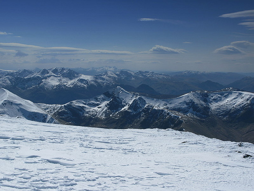
Location: Wales
Area: 934 sq mi (2,419 sq km)
The Lochaber Mountains, located in the West Highlands of Scotland, form a dramatic and rugged region within the broader Grampian Mountains, renowned for their towering peaks, deep glens, and rich geological and cultural significance. Centered around the district of Lochaber, which spans parts of Highland and Argyll, this area includes some of Britain’s highest summits, notably Ben Nevis, and is a magnet for mountaineers, geologists, and nature enthusiasts. Its landscapes, shaped by ancient tectonic forces, glaciation, and human history, tell a story of natural grandeur and resilience.
The Lochaber Mountains lie in western Scotland, roughly bounded by
the Great Glen to the north, Glen Spean to the east, Loch Linnhe to the
southwest, and the Glen Coe area to the south. The region, part of the
Lochaber district, centers on Fort William, dubbed the “Outdoor Capital
of the UK.” It encompasses iconic peaks like Ben Nevis (1,345
meters/4,413 feet), Britain’s highest mountain, and the Mamores, Grey
Corries, and Aonach Mor ranges, forming a compact but varied highland
massif.
The area spans approximately 2,000 square kilometers (770
square miles), though definitions vary, as Lochaber’s cultural
boundaries extend beyond strict geological limits. Key valleys—Glen
Nevis, Glen Roy, and Glen Spean—carve through the mountains, while lochs
like Loch Laggan and Loch Lochy add shimmering counterpoints to the
rugged terrain. The region’s proximity to the Atlantic, with Loch
Linnhe’s fjord-like waters, shapes its climate and accessibility.
The Lochaber Mountains are a study in contrasts, blending sheer peaks
with gentle plateaus:
Ben Nevis: The undisputed monarch, Ben Nevis
dominates with its massive bulk, rising from sea level at Fort William
to its summit plateau. Its north face, a 700-meter (2,300-foot) cliff,
is a premier climbing arena, riddled with gullies like Tower Ridge and
Observatory Gully. The summit, capped by a cairn and ruined observatory,
offers views to the Hebrides on clear days.
Mamores Range: South of
Ben Nevis, this chain of 10 Munros (peaks over 3,000 feet) includes
Binnein Mor (1,130 meters/3,707 feet) and Stob Ban (999 meters/3,278
feet). Known for sharp ridges and grassy slopes, the Mamores offer
challenging traverses like the Ring of Steall.
Grey Corries: East of
Ben Nevis, these quartzite-capped peaks, such as Stob Choire Claurigh
(1,177 meters/3,862 feet), gleam white in sunlight, their scree slopes
contrasting with darker schists below.
Aonach Mor and Aonach Beag:
Northeast of Ben Nevis, these twins—Aonach Mor (1,221 meters/4,006 feet)
and Aonach Beag (1,234 meters/4,049 feet)—form a high plateau, with
Aonach Mor hosting a ski resort, rare for Scotland.
Glen Coe: While
technically separate, Glen Coe’s peaks, like Buachaille Etive Mor (1,022
meters/3,353 feet), are often included in Lochaber’s orbit due to
proximity and shared geology. Its steep ridges and U-shaped valley are
iconic.
Glens, such as Glen Nevis, cradle rivers like the Water
of Nevis, while corries (glacial cirques) like Coire Leis on Ben Nevis
hold tarns and snowfields, some persisting year-round. The mountains’
elevation, though modest globally, feels dramatic due to their rise from
near sea level, creating a compressed, alpine-like intensity.
The Lochaber Mountains are a geological mosaic, forged over 800
million years:
Caledonian Orogeny: Around 400 million years ago,
tectonic collisions during the formation of the supercontinent Pangaea
thrust up the Grampians, including Lochaber’s core. Metamorphic
rocks—schists, gneisses, and quartzites—dominate, with Ben Nevis’ lower
slopes formed of mica schist and its summit of andesite lava, evidence
of ancient volcanism.
Devonian Volcanism: The Glen Coe area, part of
Lochaber’s southern fringe, hosts a collapsed caldera from a
supervolcano (c. 420 million years ago). Its rhyolite and basalt cliffs,
like those of Buachaille Etive Mor, draw geologists worldwide.
Glaciation: The last Ice Age (ending c. 10,000 BCE) sculpted Lochaber’s
U-shaped glens, hanging valleys, and arêtes. Ben Nevis’ north face bears
glacial striations, while Glen Roy’s “Parallel Roads”—ancient shorelines
of a glacial lake—are a globally unique feature, studied since Charles
Darwin’s 1838 visit.
Mineral Wealth: Quartzite in the Grey Corries
and granite in Glen Nevis supported small-scale quarrying, though
Lochaber’s remoteness limited exploitation compared to Wales or
Cornwall. Lead and zinc traces exist, but commercial mining never
thrived.
This geological diversity underpins the region’s rugged
beauty and climbing challenges, with stable schists favoring technical
routes and loose scree testing endurance.
Lochaber’s ecosystems reflect its altitude and Atlantic exposure:
Flora: Lower slopes host Caledonian pine forests, with Scots pine,
birch, and rowan in Glen Nevis, remnants of ancient woodlands. Heather
and bilberry cloak moorlands, while alpine meadows on high ridges
feature rare Arctic species like purple saxifrage and moss campion. Peat
bogs in Glen Roy store carbon, vital for climate goals.
Fauna: Red
deer roam widely, their numbers managed to prevent overgrazing. Golden
eagles and peregrine falcons soar above corries, with ptarmigan and
mountain hares adapting to summits. Otters and salmon thrive in the
Teith and Lochy rivers, while pine martens, reintroduced, reclaim
forests. Lochaber’s marine fringe supports seals and porpoises in Loch
Linnhe.
Conservation: Nevis Range and Glen Coe lie within National
Scenic Areas, with parts of Glen Nevis in the Ben Nevis Site of Special
Scientific Interest (SSSI). The John Muir Trust and NatureScot protect
habitats, combating invasive rhododendrons and restoring native trees.
Climate change threatens snowfields, with Ben Nevis’ summit snow
shrinking, impacting species like the snow bunting.
Challenges
include balancing tourism—over 150,000 climb Ben Nevis annually—with
erosion control. Paths like the Ben Nevis Mountain Track are maintained,
but scree damage and litter strain resources.
Lochaber’s maritime climate is wet and changeable, shaped by Atlantic
fronts:
Rainfall: Annual precipitation averages 2,000–3,500 mm, with
Ben Nevis’ summit among Scotland’s wettest spots. Fort William sees 200
rainy days yearly.
Temperature: Summers range 10–20°C (50–68°F),
winters 0–8°C (32–46°F), with summits dropping to -10°C (14°F). Snow
lingers on north faces into June.
Winds: Westerly gales, often 50–100
mph on peaks, pose risks, as do sudden fogs reducing visibility to
meters.
Microclimates: Glen Nevis’ sheltered floor is milder, while
Aonach Mor’s plateau catches fierce blizzards. Fort William, at sea
level, avoids extremes.
Weather shifts rapidly—hikers may face
sun, rain, and sleet in hours. Climate change shortens snow seasons,
impacting skiing, but increases landslide risks from heavier rains.
Human Geography and Access
Lochaber’s population centers on Fort
William (10,000), with smaller villages like Spean Bridge and
Kinlochleven. Roads (A82, A86) and the West Highland Line link to
Glasgow (100 miles south), while ferries from Mallaig connect to Skye.
Trails like the West Highland Way, ending in Fort William, draw 100,000
walkers yearly, with hostels and campsites catering to them.
Access to peaks is open under Scotland’s “right to roam,” but paths
vary:
Ben Nevis Mountain Track: A 17-kilometer round trip from Glen
Nevis, gaining 1,300 meters, takes 6–8 hours. It’s busy but eroded, with
cairns guiding through scree.
Mamores and Grey Corries: Tracks from
Kinlochleven or Spean Bridge lead to ridges, requiring navigation
skills. The Ring of Steall starts at Steall Falls’ wire bridge.
Glen
Coe: The A82 offers carpark access to Buachaille Etive Mor’s ridges,
with shorter hikes to Hidden Valley.
Safety is critical—20 deaths
occur annually on Ben Nevis due to falls or exposure. Lochaber Mountain
Rescue, based in Fort William, responds to 100+ callouts yearly, urging
hikers to carry maps, compasses, and bivvy bags.
The Lochaber mountains have steered human life here for thousands of
years, from ice-age shorelines and hunter camps to clan strongholds,
Jacobite musters, hydro tunnels, and modern Munro and downhill racing.
Prehistory. After the last ice sheets pulled back, Mesolithic hunters
and gatherers moved into post-glacial Lochaber from about 8500 to 4000
BCE. They lived mainly along the coast, leaving shell middens and flint
tools - blades, scrapers, and microliths - at sites such as Loch Doilean
in Sunart. Inland, Glen Roy still shows the Parallel Roads: three
ice-dammed lake shorelines cut into the hillsides around 12,100-11,600
years ago, when glaciers blocked the Spean and Roy valleys. Bronze Age
cairns mark later use of the glens for grazing and burial. In the Iron
Age, people built hillforts. Dun Deardail (Derdriu’s fort) on a knoll
above Glen Nevis, opposite Ben Nevis, was raised around the 5th century
BCE. Its timber-laced stone ramparts were later vitrified - fused into a
glass-like mass - by a catastrophic fire around 310 BCE. The fort was
briefly reoccupied, then abandoned. Finds include stone tools and traces
of bronze and iron working.
Clan era. By the late medieval period
Lochaber was Cameron country. The clan grew from a confederation of
MacMartins of Letterfinlay, MacGillonies of Strone, and MacSorleys of
Glen Nevis under Donald Dubh in the 15th century. Chiefs have been
styled Lochiel since a 1528 charter. The name Cameron is usually traced
to Gaelic cam-shròn, “crooked nose.” Their long feud with Clan
Mackintosh and the Clan Chattan Confederation over Lochaber lands lasted
about 360 years and ended with the 1665 stand-off at the Fords of
Arkaig. Sir Ewen Cameron of Lochiel built the first Achnacarry around
1655 on the isthmus between Loch Lochy and Loch Arkaig (Gaelic achadh na
caraidh, “field of the weir”), away from Mackintosh lands and the
Cromwellian garrison at Inverlochy. That timber house was burned by
government troops after Culloden. The present Scottish Baronial house,
begun in 1802 and finished in 1837, is still the clan seat. Ben Nevis,
Gaelic Beinn Nibheis, is linked to the River Nevis. Suggested meanings
include “venomous” or “malicious,” “the misty one,” or “mountain with
its head in the clouds.” The peak carried spiritual weight; early
travellers and later pilgrims treated the ascent as more than a walk.
Jacobite rebellions. Lochaber was a Jacobite heartland. After the 1689
rising, government forces built Fort William in 1690 to hold the clans;
it was later strengthened after the 1692 Massacre of Glencoe. On 19
August 1745 Charles Edward Stuart raised his standard at Glenfinnan,
about 20 miles west of Fort William. Donald Cameron of Lochiel - the
“Gentle Lochiel” - brought a large Cameron contingent to the ’45.
Jacobites later besieged Fort William (March-April 1746) but failed to
take it. After Culloden, Hanoverian troops burned old Achnacarry and
garrisoned the glens. Disarming acts, the ban on tartan and pipes, and
later sheep clearances emptied many Lochaber settlements. Early
19th-century evictions on Cameron land were among the first in the
district.
Industrial age. The West Highland Line, opened in 1894,
skirted Lochaber and put Ben Nevis within reach of Victorian climbers
and tourists. A summit observatory ran from 1883 to 1904; its ruins and
an emergency shelter still mark the top. Weather records from those
years remain a key source for Highland climate, and C. T. R. Wilson
later credited time on the summit with inspiring the cloud chamber.
Hydro power, not mining, drove heavy industry. The Kinlochleven smelter
opened in 1909, fed by the Blackwater Dam, and closed in 2000; the power
station still feeds the grid. The larger Lochaber works at Fort William
produced its first aluminium in December 1929. A 15-mile tunnel from
Loch Treig through the Ben Nevis massif supplied the plant. It is now
the last primary aluminium smelter in the United Kingdom.
Modern era.
Outdoor tourism is the main economy. Fort William and Nevis Range on
Aonach Mòr hosted the UCI Mountain Bike Downhill World Cup from 2002 for
two decades, drawing around 20,000 spectators on peak weekends. The UK’s
only mountain gondola serves both racers and walkers. Munro-bagging
remains a draw: there are 282 Scottish Munros (peaks over 3,000 ft / 914
m). The Mamores ridge between Glen Nevis and Loch Leven holds 10 of
them, including Binnein Mòr (1,130 m). Classic rounds such as the Ring
of Steall and Tranter’s Round start here. Glen Coe’s peaks have appeared
as a backdrop in Harry Potter films; Glen Nevis and nearby glens have
also been used for Highland settings in other productions. The annual
Ben Nevis Race, first timed in 1895 from Fort William to the summit and
back (about 14 km and 1,340 m of climb), still starts at Claggan Park.
The men’s record is 1 hour 25 minutes 34 seconds, set by Kenny Stuart in
1984.
Culture. Lochaber still reads as Highland country. Gaelic
survives in place names - Aonach (ridge), Coire (cirque), Beinn, Glen,
Loch - and in music. In Fort William and East Lochaber, speakers are a
small minority (around 6 percent in recent census figures for the
district, down from well over half a century ago), but ceilidhs continue
in town pubs and halls. Lochaber has hosted the Royal National Mòd
several times. Highland Games in the area keep caber tossing, hammer,
and piping in public view. Clan Cameron maintains a museum at
Achnacarry. Together the mountains, glens, and lochs still set the pace
of work, travel, and festival life.
The peaks of Lochaber are among Scotland’s classic mountaineering
grounds, and each range has a character of its own.
Ben Nevis, often
called simply the Ben, presents two very different mountains. Walkers
use the gentler Mountain Track, once the Pony Track, while winter
climbers treat the north face as a serious arena of Grade V ice. The
broad summit plateau is frequently lost in cloud. A war memorial and a
trig point mark the top.
The Mamores reward scramblers. Sharp,
knife-edge ridges define summits such as Am Bodach (1,032 m / 3,386 ft).
The Ring of Steall links four Munros in a 16-kilometre circuit that can
take around 10 hours and is regarded as one of the great days in the
western Highlands.
The Grey Corries feel quieter. Sgurr Choinnich Mor
(1,094 m / 3,589 ft) and its quartzite ridges give solitude and long
views across to the cliffs of Ben Nevis.
Aonach Beag stands higher
than neighbouring Aonach Mor yet sees fewer people. Its remote corries
suit wild camping. Aonach Mor is the more accessible twin: a gondola,
opened in 1989, carries skiers in winter and walkers in summer.
Carn
Mor Dearg reaches 1,220 m (4,003 ft). The Carn Mor Dearg Arete that runs
from here to Ben Nevis is a classic, exposed ridge walk with drops of
around 1,000 metres on either side.
Lower ground adds contrast. Glen
Nevis holds Steall Falls, a 120-metre cascade. Glen Roy is famous for
the Parallel Roads, the ancient shorelines of ice-dammed lakes. Both
glens can be reached by car or on foot.
Heavy use leaves a mark. Foot traffic on the Ben Nevis path loosens
scree, and repairs have been estimated at around £100,000 a year.
Volunteer groups such as Friends of Nevis help keep the routes in order.
Litter is another pressure: visitors leave several tonnes of waste on
Ben Nevis each year, and the Nevis Landscape Partnership organises
regular clean-ups.
Climate change is shortening the ski season on
Aonach Mor. Intense rain also weakens slopes, as shown by landslides in
the Glen Coe area in 2023. Crowds put strain on parking and disturb deer
and other wildlife. Signs ask walkers to stay on paths so that fragile
plants survive.
Restoration work is underway. Rewilding plans include
large-scale tree planting across Lochaber, with a widely cited target of
two million trees by 2030. Hydropower from Loch Laggan supplies
renewable energy. Nevis Range has set a carbon-neutral goal for 2040,
trying to keep tourism and ecology in better balance.
Why the
Lochaber mountains matter
This is the wild core of the Scottish
Highlands: raw geology shaped by ice, then by people. Ben Nevis tests
climbers. Glen Coe has long fed poetry and film, including familiar
Harry Potter landscapes. The Mamores still offer quiet. The glens once
sheltered clans. The ridges later stood against larger powers. Today the
same trails welcome walkers from around the world. From the Parallel
Roads to the summit of the Ben, Lochaber joins science, history and
story in a landscape that feels both ancient and alive.