Location: County Fermanagh Map
Tel. 028 6634 8855
Open: end- Mar- June & Sept 10am- 4:30pm daily
July- Aug 10am- 5pm daily
Official site
The Marble Arch Caves, nestled in the heart of County Fermanagh in
Northern Ireland, rank among Europe’s most spectacular show caves.
Famous for their vast underground network and breathtaking geological
formations, they take their name from the nearby Marble Arch—a striking
natural limestone bridge that spans a deep gorge. The caves form the
centerpiece of the Marble Arch Caves Global Geopark, a UNESCO-recognized
area that stretches across the border between Northern Ireland and the
Republic of Ireland, protecting a unique karst landscape on both sides.
First explored in 1895 by the renowned French speleologist
Édouard-Alfred Martel, the caves quickly gained international attention.
Today, they are one of Northern Ireland’s premier tourist attractions,
drawing visitors from around the world for immersive guided tours. These
tours reveal not only the caves’ natural beauty but also their
remarkable geological story, offering a rare glimpse into millions of
years of Earth’s history.
The Marble Arch Caves lie in County Fermanagh, near Florencecourt, on
the northern flanks of Cuilcagh Mountain. They sit at the heart of the
Cuilcagh Lakelands UNESCO Global Geopark, the first geopark in the world
to straddle an international border. The rock that holds them is
Carboniferous limestone, laid down about 330 to 340 million years ago
when this part of Ireland sat near the equator on the edge of a
supercontinent. A warm, shallow tropical sea covered the land. Lime-mud
settled on the seafloor together with the shells and skeletons of
corals, brachiopods, and other marine life. Over millions of years those
sediments compacted into beds of calcium-carbonate rock, now assigned
mainly to the Glencar Limestone Formation and the Knockmore Limestone
Member of the Dartry Limestone Formation.
Slightly acidic rainwater,
charged with carbon dioxide from air and soil, later found the
weaknesses in that rock: bedding planes, joints, and fractures. It
dissolved the highly soluble limestone grain by grain and opened a
branching network of passages, high chambers, and active underground
rivers. Three streams that drain the north side of Cuilcagh (the
Owenbrean, Aghinrawn, and Sruh Croppa) disappear into swallow holes on
the Marlbank plateau, meet underground, and become the Cladagh River.
The combined water reappears at Ireland’s largest karst resurgence,
pouring out beneath a cliff and flowing under the natural limestone span
that gives the caves their name. When wet, that arch takes on a
polished, marble-like sheen. The surveyed system now stretches about
11.5 km, the longest cave network in Northern Ireland. Uranium-series
dating of calcite shows that parts of the system are at least 75,000
years old; some deposits push the age back beyond 380,000 years. Ice-age
glaciation later modified both the surface and the passages.
The
surrounding landscape is classic upland karst: sinkholes (dolines), dry
valleys, disappearing streams, limestone gorges, and powerful springs.
Because the limestone is unusually pure, many cave walls and ceilings
gleam with a smooth, almost marble finish. Mineral-rich water has also
coated them with sparkling calcite.
Key geological features
Stalactites and stalagmites. These form when water carrying dissolved
calcium carbonate drips from the ceiling or seeps from the floor.
Stalactites hang like icicles; stalagmites rise from the ground. In
Marble Arch many of the hanging forms are slender, hollow “soda straws,”
some thin enough to look translucent. Growth is slow, often on the order
of one centimetre every thousand years. Over tens of thousands of years
the deposits can reach impressive size. Named examples on the show-cave
route include the tall Guardian Angel stalactite above the Pool Chamber
and the row of parallel stalactites known as the Organ Pipes.
Flowstones. Sheet-like calcite coats walls and slopes in
frozen-waterfall shapes and undulating curtains. Trace minerals produce
subtle colour bands. One of the largest, the Porridge Pot, is estimated
to have taken around 50,000 years to form.
Columns. When a
downward-growing stalactite meets an upward-growing stalagmite they fuse
into a pillar. Some of these reach considerable height and thickness and
give the larger chambers a monumental character.
Helictites. These
rare, twisted growths curve sideways or even upward, apparently ignoring
gravity. Capillary action, rather than simple dripping, shapes them.
They appear in places such as Skreen Hill One and are a particular draw
for geology visitors.
Other decorations include gour pools (rimstone
dams), calcite curtains, and sandy beaches that have never seen
daylight. Passages such as the Grand Gallery, Stalactite Chamber, Pool
Chamber, and the low-roofed Moses Walk (where a thin shale band pinches
the ceiling) show how bedding planes and faults steered the water.
French speleologist Édouard-Alfred Martel and Irish naturalist Lyster
Jameson first explored the main passages by candlelight and canvas boat
in 1895. The show cave, with walkways, lighting, and a short underground
boat ride on the Cladagh, opened to the public on 29 May 1985. A typical
guided visit lasts about 75 minutes and keeps a near-constant 10 °C. The
same slow processes that built the formations continue today; even a
century of human visits adds only a millimetre or two to a large
stalactite.
The Marble Arch Caves form an extensive underground network
stretching more than 11.5 kilometers (7.1 miles) in total length.
However, only a scenic 1.5-kilometer (0.9-mile) section is open to the
public as a show cave. The standard guided tour lasts approximately 75
minutes and offers a memorable two-part experience: a gentle boat
journey followed by a walking exploration through beautifully
illuminated chambers.
Boat Journey
Tours begin with a short,
atmospheric boat ride along the subterranean Cladagh River, one of the
longest known underground rivers in the United Kingdom. This clear river
originates high on the slopes of Cuilcagh Mountain and eventually
resurges dramatically in the picturesque Cladagh Glen. As the boat
glides silently through the narrow passages, visitors are surrounded by
dramatic rock formations lit with subtle lighting. The low ceilings,
echoing drips of water, and the gentle current create a serene yet
awe-inspiring introduction to the hidden world beneath the surface.
Walking Section
After disembarking from the boat, guests continue
on foot through a series of impressive chambers, including the majestic
Grand Gallery, the reflective Pool Chamber, and the atmospheric Moses
Walk.
The Grand Gallery impresses with its soaring height and
magnificent calcite formations, including towering columns and delicate,
flowing curtains of stone.
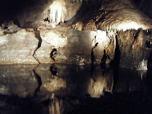
In the Pool Chamber, crystal-clear pools
mirror the ceiling above, framed by smooth, glistening flowstones that
resemble frozen cascades.
The Moses Walk follows a narrow,
water-splashed pathway where visitors feel immersed in the cave’s raw,
natural state — with moisture constantly dripping from the walls and
ceiling.
Lighting and Accessibility
Carefully designed
artificial lighting highlights the most spectacular formations while
preserving pockets of natural darkness to maintain the cave’s mysterious
ambiance. The pathways are paved and equipped with handrails for safety,
but the route includes uneven surfaces, occasional steps, and some low
sections. Because of this, the tour is not recommended for visitors with
significant mobility impairments or those using wheelchairs.
The Great Stalactite: One of the standout attractions is this
exceptionally large stalactite, which hangs dramatically for several
meters — a true geological masterpiece.
Calcite Curtains: Elegant,
paper-thin sheets of translucent calcite drape from the ceiling like
delicate stone curtains, glowing with warm hues when illuminated.
Underground Rivers: The Cladagh River is highly responsive to rainfall.
During periods of heavy rain, water levels can rise rapidly, sometimes
flooding sections of the cave and leading to tour cancellations for
safety reasons.
Fossils: Embedded within the ancient limestone walls
are numerous marine fossils, including corals, crinoids, and shells.
These fossils provide a fascinating glimpse into the tropical sea that
covered this region approximately 330 million years ago during the
Carboniferous period.
The Marble Arch Caves support a specialized ecosystem adapted to
complete darkness and high humidity. While large animals are absent, the
caves are home to a variety of small invertebrates, such as cave
spiders, springtails, and tiny crustaceans that thrive in the damp,
nutrient-poor environment.
Bats, including the Daubenton’s bat,
occasionally use quieter parts of the cave system for roosting, though
they are rarely spotted during public tours.
Above ground, the
surrounding Marble Arch Caves Global Geopark boasts far richer
biodiversity. Vast blanket bogs, ancient woodlands, and species-rich
grasslands support rare plants such as the beautiful globeflower
(Trollius europaeus), along with a wide variety of birds, insects, and
other wildlife.
The Marble Arch Caves have likely been familiar to local residents
for hundreds of years, with mentions appearing in historical records as
far back as the 18th century. However, systematic scientific exploration
only began in the late 19th century. In 1895, the renowned French
speleologist Édouard-Alfred Martel, accompanied by Dublin-born
naturalist Lyster Jameson, conducted the first detailed survey of the
passages. Navigating the dark, watery chambers by candlelight and
magnesium flares—and using a small canvas boat—they mapped approximately
300 meters of underground river passages, including the dramatic
junction where three streams converge.
Explorations continued
throughout the 20th century, gradually revealing more of the extensive
karst system. The caves were officially opened as a show cave in 1985
(now celebrating over 40 years as a visitor attraction), with the
addition of safe walkways, staircases, and electric lighting to make the
subterranean wonders accessible to the public. Their significance was
formally recognized when the area became one of Europe’s first European
Geoparks in 2001; it later achieved UNESCO Global Geopark status (now
known as the Cuilcagh Lakelands UNESCO Global Geopark), highlighting its
outstanding geological value and cross-border importance between
Northern Ireland and the Republic of Ireland.
Guided Tours: The caves are best experienced on fully guided tours,
which typically last 60–75 minutes. Tours generally run daily from March
to October, with the visitor centre open from 9:00 AM to 5:00 PM
(extended hours during peak summer and Easter periods). In winter and
off-season months, access is more limited or may close temporarily due
to high water levels and flooding risks from the active underground
rivers. Advance booking is strongly recommended, especially on weekends
and holidays, as group sizes are capped at around 21 people per tour for
safety and quality.
Current ticket prices (as of 2026) are
approximately £16 for adults, £8 for children (5–17 years), with family
tickets available (e.g., 2 adults + 2 children for £40). Concessions
apply for students and seniors. Children under 5 are free but must have
a ticket and be accompanied. Depending on water levels, standard walking
tours may be upgraded at no extra cost to the longer Martel Tour, which
includes a short, atmospheric underground boat ride along the Owenbrean
River.
Facilities: The modern visitor centre features informative
exhibits on cave geology and formation processes, local wildlife
(including bats), and the broader Geopark story. There’s also a café for
refreshments, a well-stocked gift shop, toilets, and picnic areas. Just
outside, scenic walking trails lead through the beautiful Cuilcagh
Lakelands landscape and Cladagh Glen (note: Cladagh Glen access may be
restricted at times).
Safety and Conditions: Inside the caves, the
temperature remains a constant, cool 10°C (50°F) year-round, with very
high humidity that can make surfaces slippery. Visitors should wear
sturdy, closed-toe shoes with good grip and bring warm clothing or a
light jacket. The tour involves steps and some uneven paths, so it is
not suitable for pushchairs or those with significant mobility issues.
Official advice recommends against bringing very young children (under
5) or anyone with claustrophobia, although many families with older
children enjoy the experience. All tours are led by knowledgeable
guides, and safety equipment like helmets is provided for certain
sections.
Special Tours: For more adventurous visitors, extended
“Adventure” or explorer-style tours venture into undeveloped, unlit
sections of the cave system. These require helmets, proper caving gear,
and advance booking, offering a thrilling glimpse into the raw, wilder
parts of the underground network.
The Marble Arch Caves sit at the centre of the Cuilcagh Lakelands
UNESCO Global Geopark, a rare karst landscape of limestone pavements,
swallow holes, dry valleys, and hidden rivers that stretches across the
Fermanagh–Cavan border. The geopark promotes education, conservation,
and sustainable tourism. It was one of Europe’s first geoparks (2001),
gained global status in 2004, and in 2008 became the world’s first
transnational UNESCO Global Geopark, a living symbol of cooperation
between Northern Ireland and the Republic of Ireland. The wider park now
covers more than 2,300 km² and includes blanket bog, drumlins,
prehistoric tombs, forests, and viewpoints such as the Magho Cliffs over
Lough Erne.
The caves themselves form Northern Ireland’s longest
known cave system: about 11.5 km of passages cut through Carboniferous
limestone that accumulated around 330–340 million years ago when this
part of Ireland lay near the equator under a shallow tropical sea. Three
streams that drain the northern slopes of Cuilcagh Mountain - the
Owenbrean, Aghinrawn, and Sruh Croppa - sink into the Marlbank plateau,
meet underground at The Junction, and resurface as the Cladagh River
beneath a natural limestone arch. That polished arch, which gleams like
marble when wet, gives the caves their name. The Cladagh then races
through Cladagh Glen, one of Ireland’s largest karst resurgences.
French speleologist Édouard-Alfred Martel and Dublin naturalist Lyster
Jameson first entered the system by canvas boat in July 1895. Yorkshire
Ramblers mapped more of it in 1907–08; later cave-diving opened deeper
routes such as the Legnabrocky Way. Fermanagh District Council opened a
show cave on 29 May 1985. More than 2.5 million visitors have since
walked and floated through the lit chambers. A typical 60–75 minute
guided tour (when water levels allow) starts with a short boat ride on
the peaty underground Cladagh, continues on foot past the Pool Chamber
and Grand Gallery, and follows the Owenbrean through the Moses Walk - a
walled path set into the riverbed - toward calcite formations in the
Calcite Cradle. Speleothems here grow extremely slowly; some flowstone
has been dated to around 320,000 years.
Local folklore treated the
darkness as a threshold to another world. Stories spoke of witches,
ghosts, and the daoine sídhe (fairies who were not the gentle kind). One
tale tells of a girl named Maggie Duffy who fell through the Marble Arch
and was saved by her wide skirts. The caves remain a working laboratory
for limestone dissolution, hydrology, and dye-tracing of underground
flow.
Marble Arch Caves sit inside a living karst system. Three mountain
streams - the Owenbrean, Aghinrawn and Sruh Croppa - sink on the
northern slopes of Cuilcagh, run through limestone, and reappear as the
Cladagh River at the natural marble arch that gives the site its name.
Formations grow at a geological pace. Timed, low-impact lighting is used
so algae does not coat stalactites, flowstone and calcite veils. Visitor
numbers are limited and tours run on a fixed timetable (groups of up to
21) so heat, breath and footfall stay within what the cave can absorb.
The same water that carved the passages can close them. After heavy rain
the underground rivers rise to the roof, tours are shortened or
cancelled, and silt can be dumped on paths. Persistent rain also speeds
erosion and can shift flow paths. In the late 1980s and early 1990s
mechanised peat-cutting, drainage ditches and overgrazing on Cuilcagh’s
blanket bog stripped the mountain of its sponge. Water that once soaked
into peat raced off the slopes and produced sudden floods in the show
cave (notably in 1989). Cuilcagh Mountain Park was created in 1998, with
restoration work under an EU LIFE project: peat cutting stopped, grazing
was reduced, and more than a thousand small dams were placed in old
drains so the bog could hold water again. The park opened in 1999. The
blanket bog is now a Special Area of Conservation and Ramsar wetland.
Healthy peat stores carbon and meters runoff; damaged peat does the
opposite.
Climate-driven rainfall intensity is now the main long-term
risk. Annual rainfall is already high (about 1,270 mm at the visitor
centre and over 2,000 mm on the summit). Intense bursts can still
overwhelm the system, as in July 2025 when tours had to be evacuated and
the cave closed for clean-up. Conservation aims to keep public access
without sacrificing geology that took hundreds of thousands of years to
form. The wider setting is the Cuilcagh Lakelands UNESCO Global Geopark
(formerly Marble Arch Caves Global Geopark), a cross-border landscape of
karst, blanket bog, forest and lakes jointly managed by Fermanagh and
Omagh District Council and Cavan County Council.
Address: 43 Marlbank Road, Florencecourt, Enniskillen, County
Fermanagh, BT92 1EW (what3words: super.sideboard.travel). The site lies
about 12–16 km southwest of Enniskillen and 4 km west of Florence Court
House. Driving time is roughly two hours from Belfast or Dublin. From
Enniskillen take the A4 Sligo Road, join the A32 after about 5 km, then
follow local signs for Marble Arch / Florencecourt. Parking at the
visitor centre is free and ample for cars, campervans and coaches, with
EV charging and Blue Badge bays. The car park is locked outside opening
hours.
Public transport is limited. A seasonal Translink bus from
Enniskillen Bus Station has operated in summer (typically 1 July–31
August, Monday–Friday): outbound around 11:45, return from the caves
around 16:30. Fares have been in the region of £5.40 adult day return
and £2.70 child. Outside those dates a car, taxi (roughly £25–30 each
way from Enniskillen) or organised coach tour is the practical choice.
Book cave-tour tickets online in advance, especially in peak months.
Arrive 30 minutes before your slot. The guided tour lasts 60–75 minutes
and covers about 1.5 km. When water levels allow, the ticket is upgraded
at no extra cost to the longer Martel Tour, which includes a short
underground boat trip. If the river is too high you walk the Owenbrean /
Canyon Passage route instead. Tours can be shortened or cancelled after
persistent rain; always check the official site on the day of travel.
Underground temperature stays around 9–10 °C year-round, so bring a
layer even in summer. Wear sturdy shoes: the route includes about 154
steps on entry and exit and is not fully wheelchair-accessible.
Pushchairs are not allowed below ground. A Virtual Reality Cave Explorer
option is available when the physical tour is restricted or for visitors
who cannot manage the steps.
Nearby extras include the Cladagh Glen
trail to the namesake limestone arch (status can change - check before
you go), Florence Court House and forest (National Trust), Killykeeghan
Nature Reserve (toilets and interpretation, typically 10:00–16:00), and
the Cuilcagh Boardwalk / “Stairway to Heaven.” Sections of the boardwalk
and summit route have been closed at times to protect fragile blanket
bog; stay on the designated path. The visitor centre has exhibits on
geology and peatland restoration, a café, a shop, toilets (including
accessible), free Wi-Fi and picnic space. Allow about two hours for the
centre plus tour.