Location: Beeston, Cheshire County Map
Constructed: 1220's by Ranulf de Blondeville
Prehistoric occupation
Worked flint tools show people were
already on the crag in the Neolithic period (roughly 4000-2400
BC). Early Bronze Age burial mounds and funerary material appear
on the lower slopes, pointing to ritual as well as practical use
of the hill.
Around 1000 BC a simple bank, probably topped by
a wooden palisade, was thrown up at the base of the crag. By
about 800 BC the hilltop had become a regional metalworking
centre. Excavations in the later 20th century uncovered Bronze
Age roundhouses in what is now the outer ward, together with
moulds, crucibles, and two copper-alloy socketed axes that had
been buried beneath the bank - almost certainly a votive
deposit.
In the early Iron Age the bank was enlarged and
given an external ditch, creating a proper hillfort. Later Iron
Age work added a substantial earthwork bank strengthened with
stone rubble and a palisade. Plant remains and pottery linked to
Cheshire’s salt trade show the enclosure was used for storing
and processing grain and for regional exchange. The hillfort
appears to have been abandoned by the end of the Iron Age. Roman
pottery has been found at the foot of the hill, but there is
little sign of Roman occupation on the summit itself.
Ranulf de Blondeville and the 1220s castle
Ranulf de
Blondeville, 6th Earl of Chester (c.1170-1232), was a leading
magnate who had supported King John in the baronial wars and
later joined the Fifth Crusade (1218-1220). On his return he
found the new king’s justiciar, Hubert de Burgh, confiscating
lands from other great men. Ranulf responded by building three
major new castles - Beeston, Bolingbroke in Lincolnshire, and
Chartley in Staffordshire - to display his power. Work at
Beeston began in the early 1220s.
He chose the existing Iron
Age earthworks as the line of his outer bailey. The design was
modern for its date: two strong gatehouses, a rock-cut ditch up
to 30 feet deep between the baileys, D-shaped mural towers, and
no traditional keep. Defence relied on the natural cliffs on
three sides and on the massive walls and gatehouses themselves.
The inner and outer gatehouses, most of the inner curtain wall,
the great ditch, and at least one outer-ward tower belong to
this first phase. Two wells were sunk into the rock; the
inner-ward well, first recorded in the 1230s, is about 370 feet
(113 m) deep - one of the deepest castle wells in England.
The castle was still unfinished when Ranulf died in 1232. His
nephew John le Scot inherited the earldom, but John died without
a male heir in 1237. Henry III seized the estates, including
Beeston.
A royal castle, 1237-16th century
Henry III
spent large sums in the 1240s, especially during the 1245
campaign against Wales. Payments mention finishing turrets and
fortifying the site. Even so, Beeston never received a full set
of residential halls and chambers. Accommodation stayed inside
the gatehouses and towers; garrisons almost certainly used
timber buildings in the outer ward. The castle also served as a
prison for Welsh hostages.
In 1254 Henry granted Beeston and
the Earldom of Chester to his son, the future Edward I. The
title Earl of Chester has belonged to the heir to the English
throne ever since. During the Second Barons’ War the castle was
briefly held by Montfortian forces and recovered in 1265 after
Edward escaped captivity. Once Edward I had conquered Wales,
Beeston’s military importance declined beside Chester Castle,
though it remained a royal stronghold.
A major campaign of
work in 1303-4 cost more than £109. Three inner-ward towers that
had only wooden superstructures were raised and crenellated in
stone; a new stone-supported bridge and a massive retaining wall
were built across the rock-cut ditch. Further repairs followed
in 1305 and 1312-13. A 1333 survey described the castle as “well
and surely sited on a rocky eminence, and very well enclosed.”
Porters were still recorded in the 15th century, but by about
1540 the antiquary John Leland found the place ruinous. In 1602
the Crown sold the manor, including the castle, to Sir Hugh
Beeston of Beeston Hall.
A persistent legend claims that
Richard II hid treasure at Beeston in 1399 before leaving for
Ireland. Searches have concentrated on the deep well; nothing
has been found, and contemporary records suggest Henry IV
recovered Richard’s valuables from other hiding places.
The Civil War, 1643-1646
Both sides needed the crag once
fighting began in 1642. In February 1643 Sir William Brereton’s
Parliamentarians installed a garrison of 200-300 men and patched
the crumbling walls with earth. On the night of 13 December 1643
Royalist Captain Thomas Sandford and eight men from the Irish
army that had landed at Chester scaled the northern cliffs,
seized the inner ward, and forced the surrender of the startled
governor, Captain Thomas Steele. Steele was later
court-martialled and shot.
Parliament began a formal siege in
November 1644. Royalists destroyed the first siege works in
1645; the attackers then built a fort within musket-shot of the
outer gate. After Charles I’s defeat at Rowton Heath (24
September 1645) the garrison’s position became hopeless. Beeston
surrendered on 15 November 1645. The victors found almost no
food left - “neither meate, Ale nor Beere \ldots save only a
peece of Turkey pye, Twoe Bisketts, a lyve Peacock and a
peahen.” The castle was slighted in 1646 on Parliament’s orders
so it could not be used again.
Ruin, quarry, and tourist
attraction
After the war the site passed by marriage to the
Mostyn family. In the 18th century the crag was quarried; part
of the outer gatehouse was demolished to let carts in and out.
At the same time the romantic ruin began to attract artists,
including J.M.W. Turner.
In 1840 John Tollemache (later 1st
Baron Tollemache) bought the Peckforton estate, which included
Beeston. He built the mock-medieval Peckforton Castle on the
next ridge and treated Beeston’s ruins as a picturesque feature
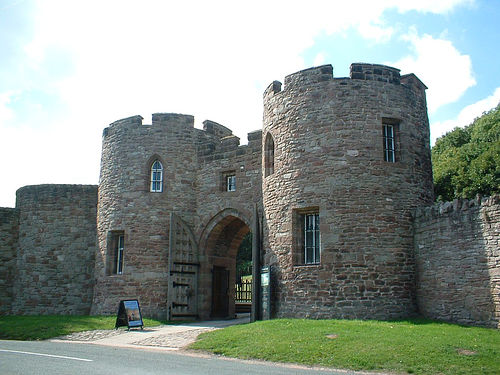
of the park. The present ticket-office lodge (an imitation of
the inner gatehouse) and the stone wall around the base of the
crag date from 1846. Fir trees were planted in the outer ward;
deer and even kangaroos were kept inside the wall. The opening
of the Chester-Crewe railway that same year turned the castle
into a popular excursion destination. Annual two-day fetes drew
thousands of visitors.
The Ministry of Works took the castle
into guardianship in 1959; English Heritage has managed it since
1984. A concrete footbridge to the inner ward was built in 1975.
The inner and outer walls and gatehouses are Grade I listed; the
whole site is a Scheduled Ancient Monument. Enough masonry
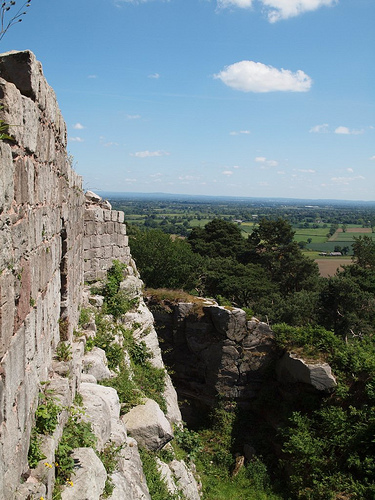
survives to show the original plan clearly, and the views from
the summit still stretch across eight counties - from the
Pennines to the Welsh mountains.
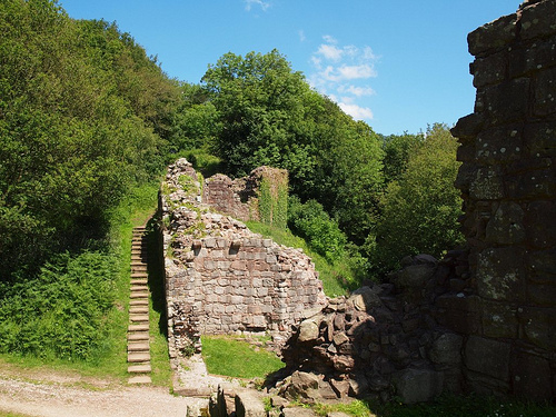
The inner ward remains
uneven and rocky, a reminder that Ranulf never finished the
residential buildings he had planned. The deep well, the
rock-cut ditch with its surviving stone pillar, and the two
gatehouses are the most complete 13th-century features. Together
they make Beeston one of the most dramatic and archaeologically
layered castle sites in England.
Overall layout and design principles
The castle comprises two
wards:
A large, roughly rectangular outer ward on the lower
slopes.
A compact inner ward on the summit, isolated by the
rock-cut ditch.
There is no keep. Accommodation and services
were housed in the gatehouses and mural towers. The inner ward’s
rocky, uneven floor and the absence of foundations for a hall or
kitchens show that the castle was never finished as a residential
complex. Its purpose was military and symbolic: a dramatic statement
of Ranulf’s power on a site that commanded views of some 30 miles.
The design belongs to an early-13th-century shift toward stronger
gatehouses and flanking towers. Beeston’s gatehouses anticipate the
great gatehouses of Edward I’s Welsh castles. The D-shaped
(open-backed) towers allowed flanking fire along the curtains while
denying cover to an attacker who had already entered the ward.
Similar towers appear at Ranulf’s contemporary castles of
Bolingbroke and Chartley. Possible Crusader influence has been noted
in the rock-cut ditch, which recalls features seen in the Holy Land.
Materials and construction
Walls are of local red sandstone,
crudely coursed, with a rubble core and dressed facing. Thickness is
typically about 1.8 m (6 ft). Arrow loops are of the “fish-tailed”
type common in Ranulf’s work. The inner-ward curtain still stands to
full height on the south-east, complete with crenellations and six
square sockets that once held the beams of a wooden hording (a
projecting fighting gallery from which missiles could be dropped
into the ditch).
Outer ward and outer gatehouse
The outer
curtain is punctuated by eight D-shaped towers (some reduced to
footings) and one later rectangular tower of the late 14th or early
15th century. The towers originally rose at least one storey above
the wall-walk. The outer gatehouse, among the first structures built
in the 1220s, consisted of two rounded towers flanking a passage; it
was originally about twice the height of the present ruin. It was
partly demolished in the 18th century to allow quarry traffic. A
ditch, originally about 5 m wide and 3 m deep, lay in front of the
gate. A second well exists in a hollow within the outer ward.
The rock-cut ditch
The most spectacular single feature is the
ditch that isolates the inner ward. Cut through solid sandstone in
the 1220s, it reaches 9 m (30 ft) deep and about 10.5 m (35 ft) wide
in places. The stone extracted was used to build the castle itself.
A pillar of uncut rock was left to support the original timber
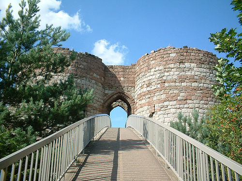
bridge. In 1303–4 a stone causeway and a “great massive stone wall”
before the bridge were added; the present concrete footbridge dates
from 1975. The ditch simultaneously served as quarry, obstacle and
visual statement of the labour and resources Ranulf could command.
Inner gatehouse and inner ward
The inner gatehouse was the
castle’s most important building and almost certainly the first to
be erected. Two D-shaped towers enclose a pointed-arched passage.
Each tower contains a ground-floor chamber with arrow slits; a
single first-floor room, spanning the passage, housed the constable.
Floor-beam sockets remain visible. The gate was defended by a
drawbridge, portcullis and double doors. The inner curtain continues
the same vocabulary of D-shaped towers. Five original battlements
survive on the best-preserved stretch.
Inside the inner ward the
ground was never levelled. No major domestic ranges were built.
Water was supplied by a well recorded already in the 1230s; at
approximately 113 m (370 ft) it is among the deepest castle wells in
England. A second well served the outer ward.
Later medieval
and post-medieval changes
Between September 1303 and September
1304 more than £109 was spent raising and crenellating three
inner-ward towers “because they formerly had high wooden surfaces.”
This confirms that some 13th-century work had been left unfinished
in timber. After the Civil War siege of 1644–45 the castle was
slighted in 1646. In 1846 John Tollemache built the present ticket
lodge, a picturesque imitation of the inner gatehouse, together with
a low enclosing wall at the foot of the crag.
Getting there
By car. Address: Chapel Lane, Beeston, Cheshire CW6
9TX. Sat-nav works. The castle is on a minor road off the A49, 11 miles
south-east of Chester. Parking is opposite the entrance (about 100
spaces). Non-members pay; members park free with a valid sticker. There
is no dedicated Blue Badge concession listed on the official access
page, though a drop-off point exists in the car park. Arrive early on
weekends and bank holidays; the lot fills. You then cross the road to
the ticket office.
By public transport. Chester station is about 11
miles away, Crewe about 15. Buses are limited: GHA 83 to Beeston on
Tuesdays; GHA 56 to Bunbury Heath (then about a 1-mile walk) on Thursday
and Saturday; Arriva 84 to Tarporley (then about 2.5 miles). Plan extra
time. Cycling is possible via the National Cycle Network.
Time on
site. English Heritage quotes an average visit of about 1.5 hours. Add
more if you do the woodland walks and picnic.
What the climb is
actually like
The visitor centre, exhibition, toilets, shop, and
kiosk sit at the foot of the hill. The castle itself is about 0.5 km
uphill. The path is steep in places, with uneven grass, stone, rabbit
holes, and a modern bridge across the rock-cut ditch into the inner
ward. Allow 15-30 minutes depending on fitness, and expect pauses for
views. Benches exist but can be occupied. Sturdy shoes are essential.
After rain the woodland paths get muddy and slippery. Wheelchair access
to the summit and woodland walk is not recommended. The exhibition and
kiosk area are the accessible parts of the site.
Keep children close.
There are sheer drops around the inner ward, a deep well with a grille,
and no climbing on the walls. No climbing is permitted.
What to
see, in order
1. Exhibition ("Castle of the Rock"). Start here. It
covers 4,000 years: Neolithic tools, Bronze Age metalworking (socketed
axeheads have been found), Iron Age hillfort banks later reused by the
medieval builders, Ranulf de Blondeville’s 1220s castle, royal ownership
under Henry III and Edward I, decline, and the Civil War siege of
1644-45. The castle was slighted in 1646 so it could not be held again.
The inner ward was never fully completed in the Middle Ages; the rocky
floor still shows that.
2. Bronze Age roundhouse. A reconstructed
building with replica pots, hides, and tools. It is one of the
best-interpreted prehistoric features on an English Heritage castle
site.
3. Outer ward and outer gatehouse. The 13th-century outer
gatehouse was among the first parts Ranulf built. The 19th-century
ticket lodge (1846, Lord Tollemache) mimics a medieval gateway and once
marked the edge of a deer (and briefly kangaroo) park.
4. Rock-cut
ditch and inner gatehouse. A deep ditch separates the wards. The
double-towered inner gatehouse is the castle’s architectural highlight.
A concrete footbridge (1975) replaces the original timber crossing.
5. Inner ward and the well. Uneven rock, fragments of curtain wall, and
one of the deepest castle wells in England. Medieval masonry goes down
tens of metres; investigations in the 1930s recorded a depth on the
order of 100-113 m. Legend says Richard II hid treasure here in 1399. It
has never been found. Peer through the grille; do not drop anything in.
6. Views. This is the reason most people come. On a clear day you look
across the Cheshire Plain toward the Pennines and the Welsh mountains.
Peckforton Castle, a 19th-century mock-medieval pile, sits on the next
ridge.
7. Woodland park. About 40 acres of paths around the base of
the crag. Wildlife includes rabbits, foxes, buzzards, and sometimes
peregrine falcons. There are picnic tables and Castle Green. The kiosk
is open to the public without a castle ticket. It sells hot and cold
drinks, pasties, sausage rolls, cream teas, ice cream, cakes, and dog
treats. Outdoor seating only. Bring a picnic if you prefer.
Practical visiting tips
Book online the day before. Gate prices are
higher.
Wear boots or sturdy trainers. The hill and wet grass punish
trainers and sandals.
Go early or late on weekdays if you want
quieter paths and easier parking. Weekends and school holidays peak
between 11am and 2pm.
Dogs are allowed on leads. Assistance dogs are
welcome. A dog bowl is provided.
Toilets (including baby change) are
at the base. Accessible toilets are listed for the visitor-centre area.
There is a shop for guidebooks and souvenirs.
Groups of 15+ can get a
discount if booked in advance. Guided tours (about 60 minutes) are
offered for groups; stout shoes required.
Combine with Chester (Roman
amphitheatre, castle walls, about 9-11 miles) or a walk/drive to
Peckforton. Tarporley village has pubs and shops a few miles away.
Check the "What’s On" listing. Seasonal events (Great British Summer
style activities, family trails, treasure-hunt style games) run in
summer.
Accessibility and safety, stated plainly
The
exhibition and kiosk area work for visitors with limited mobility. The
castle and woodland do not. Surfaces are uneven. Slopes are steep. There
are trip hazards from animal burrows, slip hazards when wet, and sheer
drops at the inner ward. English Heritage states that care must be taken
everywhere and that no climbing is allowed on the walls. If mobility is
limited, treat the visit as the exhibition plus a picnic at the base,
and enjoy the view of the crag from below.
Short historical frame
(useful before you walk)
People used Beeston Crag from the Neolithic
onward. It was a Bronze Age metalworking centre and later an Iron Age
hillfort. Ranulf de Blondeville, 6th Earl of Chester, began the stone
castle in the 1220s after returning from crusade, using the existing
earthworks. Henry III took it in 1237; it stayed royal into the 16th
century. It was refortified in the Civil War, captured by Royalists who
scaled the north cliffs in 1643, then besieged and surrendered in 1645.
Parliament slighted it in 1646. In the 19th century it became a tourist
site after the Chester-Crewe railway opened; Turner painted it. The
state took guardianship in 1959; English Heritage has managed it since
1984.