Location: Sussex Map
Age: 60- 130 million years
Height: 253 ft (77 m)
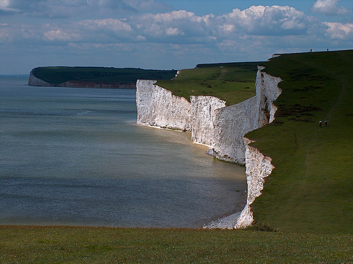
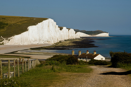
The Seven Sisters are a renowned series of undulating chalk sea cliffs located along the English Channel coast in East Sussex, England, forming part of the South Downs National Park and the Sussex Heritage Coast. Stretching approximately 4 miles (6.4 km) between the towns of Seaford and Eastbourne, these cliffs are characterized by their bright white appearance and dramatic peaks and valleys, reaching heights of up to 162 meters (531 feet). They represent a classic example of coastal erosion shaping a landscape over millennia, often compared to—but distinct from—the nearby White Cliffs of Dover due to their more rugged, undeveloped profile. The site is a popular destination for hikers, photographers, and nature enthusiasts, offering stunning views, diverse wildlife, and a sense of timeless natural beauty. It is managed by the National Trust and attracts visitors for activities like walking the South Downs Way trail, birdwatching, and exploring the adjacent Seven Sisters Country Park.
The Seven Sisters cliffs, located along the Sussex Heritage Coast in
East Sussex, England, represent a striking example of coastal geology
shaped by millions of years of sedimentary deposition, tectonic uplift,
and ongoing erosion. These undulating white chalk cliffs stretch
approximately 6 km between Seaford and Eastbourne, reaching heights of
up to 162 meters, and form part of the South Downs National Park.
Geologically, they are remnants of a vast chalk dome formed during the
Late Cretaceous period, offering insights into ancient marine
environments, fossil-rich strata, and dynamic coastal processes. Their
bright white appearance and dramatic profile result from the exposure of
pure chalk layers, making them a key site for studying Cretaceous
geology and modern erosion.
Geological Formation and Age
The
Seven Sisters cliffs originated during the Late Cretaceous epoch,
specifically the Coniacian and Santonian stages, approximately 87–84
million years ago, with broader chalk deposition spanning 100–65 million
years ago. At this time, southern England was submerged under a shallow,
warm tropical sea at around 40°N latitude, with global sea levels over
200 meters higher than today due to greenhouse conditions, active plate
tectonics, and minimal polar ice. This marine environment, far from
land, allowed for the accumulation of fine-grained sediments on the
seafloor.
The chalk formed from the skeletal remains of billions of
microscopic planktonic algae called coccolithophores, which produced
tiny calcified plates (coccoliths) of calcium carbonate. When these
organisms died, their remains sank, forming a soft calcareous ooze that
gradually compacted and lithified over millions of years into dense
chalk layers, up to 500 meters thick in the region. This process created
the White Chalk Subgroup (formerly Upper Chalk), with the cliffs
primarily exposing the Seaford Chalk Formation in the lower sections and
the Newhaven Chalk Formation at the top. The South Downs, including the
Seven Sisters, were part of a larger chalk dome extending across
southeast England, deposited in a shallow sea that covered much of the
area.
Composition and Stratigraphy
The primary rock type is
chalk, a soft, porous, fine-grained limestone composed almost entirely
of calcium carbonate (CaCO₃), giving it a distinctive white color and
crumbly texture. Interbedded within the chalk are bands of flint, a
hard, dark microcrystalline quartz formed from the siliceous remains of
sponges, diatoms, and radiolarians that accumulated and recrystallized
during diagenesis. These flint layers create contrasting horizons,
enhancing structural stability in some areas but contributing to
differential erosion.
Stratigraphically, the cliffs display a
sequence of chalk formations. The Seaford Chalk Formation dominates,
characterized by its purity and fossil content, while the overlying
Newhaven Chalk Formation includes more marly (clay-rich) layers. A
notable marker is the Seven Sisters Flint Band, a prominent dark sheet
flint near the base, visible on the foreshore and forming flint-capped
pedestals due to its resistance to erosion. At Birling Gap, the western
end, the stratigraphy varies slightly, yielding different fossils.
Overlying Quaternary sediments, such as loess from the Devensian stage
(115,000–10,000 years ago), fill dissolution pipes—vertical channels
formed by acidic rainwater dissolving the chalk along joints. The
chalk's porosity acts like a sponge, forming a major aquifer that stores
and filters rainwater, supplying local water sources.
Tectonic
History
The cliffs' current elevation results from tectonic uplift
associated with the Alpine Orogeny, the collision of the African and
Eurasian plates around 50 million years ago during the Eocene epoch.
This event folded and uplifted the chalk dome, exposing it above sea
level. Subsequent tectonic movements and isostatic rebound after the Ice
Ages further elevated the land. The South Downs ridge, including the
Seven Sisters, is an anticline (upward fold) remnant of this dome, with
the chalk dipping gently southward. Natural joints and fractures from
this tectonic stress provide pathways for erosion, contributing to the
cliffs' instability.
Erosion Processes and Landscape Evolution
Erosion has been the dominant force shaping the Seven Sisters since the
end of the last Ice Age (approximately 12,000 years ago), when rising
sea levels flooded low-lying areas and initiated marine transgression.
Wave action undercuts the soft chalk at the base, leading to collapses,
while weathering—physical (freeze-thaw) and chemical (dissolution by
rainwater)—widens cracks and creates overhangs. Heavy rainfall
exacerbates slumping, with thousands of tonnes of material falling
annually. Differential erosion, where softer layers erode faster than
flint bands, forms caves, arches, stacks, and the seven (or eight)
distinct peaks: Haven Brow, Short Brow, Rough Brow, Brass Point,
Flagstaff Point, Flat Hill, Baily's Hill, and Went Hill. The average
retreat rate is about 60 cm per year, faster at softer sections like
Birling Gap. During the Ice Ages, periglacial processes (meltwater and
frost) carved valleys like the Cuckmere, while post-glacial sea-level
rise shifted the coastline inland by up to 7 km. Longshore drift moves
eroded pebbles along the shingle beaches, influencing sediment
distribution.
Fossils and Paleoenvironment
The cliffs preserve
a rich fossil record of the Late Cretaceous marine ecosystem, including
microfossils like coccolithophores and foraminifera, as well as
macrofossils such as echinoids (Micraster, Conulus, Echinocorys),
bivalves (Neithea, inoceramids), sponges, brachiopods, crinoids,
belemnites, ammonites, starfish, and crustacean burrows (Terebella)
lined with fish scales. These indicate a diverse benthic community in a
clear, shallow sea. Fossils are abundant in loose boulders on the
foreshore, especially after storms, but collection is restricted to
loose material due to SSSI status.
Unique Geological Features
Unique aspects include the Seven Sisters Flint Band, dissolution pipes
filled with Ice Age soils, and the cliffs' rapid erosion rate, which
exposes fresh strata and fossils. The adjacent Cuckmere Valley, shaped
by fluvial and glacial erosion, features meanders and sediment deposits,
contrasting the marine cliffs. The chalk's aquifer role supports local
hydrology, a feature shared with the broader South Downs but pronounced
here due to the exposed ridge.
Human interaction with the Seven Sisters area dates back to
prehistoric times, with the chalk grassland and hills revealing multiple
layers of archaeological evidence. Neolithic (c. 4000–2500 BCE) and
Bronze Age (c. 2500–800 BCE) burial mounds, or barrows, dot the
landscape, indicating early settlement and ritual activity. The site's
strategic coastal position made it a focus for defense throughout
history. During the Napoleonic Wars (1799–1815), barracks and
fortifications were built to guard against potential French invasions.
In World War II (1939–1945), the cliffs hosted anti-tank obstacles,
pillboxes, and radar stations as part of Britain's coastal defenses
against Nazi Germany.
The modern history of preservation began in the
early 20th century. In 1926, a campaign led by environmentalists,
including author Rudyard Kipling and the Society of Sussex Downsmen (now
Friends of the South Downs), raised funds to purchase the land and
prevent residential development, ensuring its unspoilt status. This
effort culminated in the establishment of the Seven Sisters Country Park
in 1971, now covering 280 hectares and managed by East Sussex County
Council and the National Trust. The area has also been shaped by human
interventions, such as the straightening of the Cuckmere River in the
19th century for drainage, which altered local wetlands.
The Seven Sisters boast a rich biodiversity supported by diverse
habitats: chalk cliffs, grasslands, wetlands, and marine zones. The
chalk grassland, maintained by centuries of sheep grazing, is a rare
habitat with up to 40 plant species per square meter, including wild
thyme, cowslip, round-headed rampion (the county flower of Sussex), and
sea kale. This supports over 20 butterfly species, such as the chalkhill
blue and Adonis blue, thriving in summer.
The cliffs provide nesting
sites for seabirds like kittiwakes, fulmars, and peregrine falcons,
while the foreshore's rock pools harbor shore crabs, anemones, and
seaweed. Wetlands and ponds attract dragonflies, herons, and migratory
birds such as lapwings, wigeon, and black-tailed godwits. The marine
environment includes saline lagoons with glasswort and yellow horned
poppy. Conservation efforts focus on grazing to prevent scrub invasion
and protect these ecosystems.
Culturally, the Seven Sisters symbolize England's natural heritage, often featured in literature, art, and media for their dramatic scenery. The name "Seven Sisters" is linked to a local Sussex legend of seven daughters of a wealthy farmer who, in some versions, drowned in the sea, their spirits forming the cliffs; however, detailed accounts of this myth are scarce and may be apocryphal. More practically, the name likely derives from the seven visible hillocks or the historical division of the land into seven parcels for seven local families. The site has inspired works like Kipling's writings and appears in films, emphasizing its timeless appeal.
Today, the Seven Sisters are protected within the South Downs National Park (established 2010) and designated as a Site of Special Scientific Interest (SSSI) for their geological and biological value. The Seven Sisters Country Park offers visitor facilities, including a center with exhibits on local history and ecology, cafes, and guided tours. Popular activities include the 10-mile (16 km) cliff-top walk from Seaford to Eastbourne, fossil hunting at low tide (with safety warnings due to falling rocks), and wildlife spotting. Erosion remains a challenge, with ongoing monitoring and path rerouting to ensure safety. As of 2025, the site continues to draw tourists for its unspoilt beauty, with recommendations for sustainable visits to minimize environmental impact.