Location: Cayo district Map
Area: 430 km² (106,353 acres)
Mountain Pine Ridge Forest Reserve, located in the Cayo District of western Belize, is a 106,000-acre (43,000-hectare) protected area established in 1944, renowned for its unique pine forest ecosystem, dramatic granite and limestone landscapes, and a wealth of natural attractions, including waterfalls, caves, and rivers. Nestled in the Maya Mountains, it spans elevations from 1,200 to 3,000 feet (366–914 meters), offering cooler temperatures and a stark contrast to Belize’s lowland rainforests. Managed by the Belize Forest Department, the reserve is a haven for biodiversity, outdoor adventure, and archaeological exploration, with highlights like Rio On Pools, Big Rock Falls, and the Caracol Maya ruins.
Mountain Pine Ridge sits on a granite massif, part of the Maya
Mountains, with a rugged topography of rolling hills, steep escarpments,
and deep valleys. Unlike Belize’s typical tropical rainforests, the
reserve is dominated by Caribbean pine (Pinus caribaea), thriving in
poor, acidic soils over granite and some limestone outcrops. Key
geographical features include:
Pine Forests and Savannas:
Extensive stands of pine, interspersed with grassy savannas, create an
open, airy landscape reminiscent of Central American highlands.
Hardwoods like mahogany and cedar appear in river valleys.
Rivers and
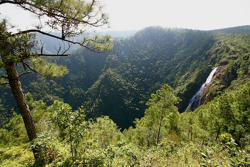
Waterfalls: The reserve is a watershed for rivers like the Macal, Mopan,
and Rio On, feeding into the Belize River. Waterfalls, such as Big Rock
Falls (150 feet) and Rio On Pools (a series of cascading granite pools),
are carved from granite and limestone.
Caves and Karst: Limestone
areas host caves like Rio Frio Cave, a massive, accessible cavern with
stalactites and an underground river. Smaller caves dot the reserve,
some with Maya artifacts.
Elevation and Climate: Elevations range
from 1,200 feet at lower points to 3,000 feet near Baldy Beacon, the
highest point. Temperatures are cooler (60–80°F, 16–27°C) than coastal
Belize, with occasional fog and chilly nights. The dry season
(November–May) is ideal for exploration, while the wet season
(June–November) enhances waterfalls but muddies roads.
The reserve’s
granite base, rare in Central America, contrasts with Belize’s limestone
karst, creating a unique ecological niche. Its isolation, with no
permanent settlements, preserves its pristine state, though dirt roads
require 4WD vehicles for access.
Mountain Pine Ridge’s history spans geological formation, Maya
occupation, colonial exploitation, and modern conservation:
Geological Formation: The reserve’s granite massif formed millions of
years ago during tectonic uplift, with erosion sculpting valleys and
waterfalls. Limestone deposits, from ancient seabeds, overlay parts of
the granite, hosting caves.
Maya Era: The region was a Maya
stronghold, with Caracol, one of Belize’s largest archaeological sites,
flourishing from 600 BCE to 900 CE. Located within the reserve’s
southern boundary, Caracol was a major city-state rivaling Tikal, with
over 100,000 residents at its peak. Smaller sites, like caves with
pottery, indicate ritual use.
Colonial and Modern Era: British
loggers exploited the area’s pine and mahogany in the 19th century,
floating timber down the Macal River. Overlogging and fires prompted the
reserve’s establishment in 1944 to protect remaining forests. The Belize
Forest Department has since managed it, balancing conservation with
limited logging.
Conservation Challenges: A 2001–2010 southern pine
beetle infestation devastated pine stands, killing up to 80% of mature
trees in some areas. Reforestation and natural regeneration have
restored much of the forest, though dead trunks remain visible. The 2008
Chiquibul Reserve expansion strengthened regional protection.
Mountain Pine Ridge supports a unique ecosystem, distinct from
Belize’s lowland jungles, with species adapted to pine forests and
highland conditions:
Flora: Caribbean pine dominates, with
savanna grasses, palmettos, and orchids. Riverine forests host mahogany,
cedar, and strangler figs. Post-beetle reforestation includes native and
exotic pines.
Birds: Over 200 species, including orange-breasted
falcons (endangered, nesting on granite cliffs), Stygian owls,
azure-crowned hummingbirds, acorn woodpeckers, and hepatic tanagers.
Raptors like black hawk-eagles and king vultures soar above.
Mammals:
Elusive jaguars, ocelots, pumas, and margays roam the reserve, with
tracks often seen near rivers. Baird’s tapirs, white-tailed deer, and
collared peccaries are present but shy. Howler monkeys inhabit riverine
forests.
Reptiles and Amphibians: Fer-de-lance snakes (venomous,
requiring caution), green iguanas, and Morelet’s crocodiles (in rivers)
are notable. Frogs, like the Rio Grande leopard frog, thrive post-rain.
Insects: The southern pine beetle’s impact lingers, but butterflies and
dragonflies add vibrancy.
The reserve’s biodiversity, while less
dense than rainforests, is critical for highland species, with ongoing
monitoring to protect endangered fauna like the orange-breasted falcon.
The reserve’s cultural significance lies in its Maya heritage,
centered on Caracol:
Caracol Archaeological Site: Spanning
200 square kilometers, Caracol features over 35,000 structures,
including the 141-foot Caana pyramid, Belize’s tallest man-made
structure. At its peak (650 CE), it housed 100,000–150,000 people,
with causeways linking plazas, reservoirs, and residential zones.
Artifacts like altars, stelae, and ball courts reveal a
sophisticated society. Recent LiDAR surveys uncovered extensive
agricultural terraces and causeways, highlighting Caracol’s urban
complexity.
Cave Rituals: Rio Frio Cave and smaller caves contain
Maya pottery and relics, used for ceremonies to honor underworld
gods. These sites, less excavated, add mystique.
Modern Context:
The absence of settlements within the reserve preserves its wild
character, but nearby communities like San Antonio and Douglas
D’Silva (Augustine) engage in guiding and cultural tours, sharing
Kriol and Maya traditions.
Mountain Pine Ridge is a playground for adventure and nature
enthusiasts, with attractions accessible via dirt roads and trails:
Waterfalls:
Big Rock Falls: A 150-foot cascade into a deep,
jade-green pool, ideal for swimming. Reached via a steep, 10-minute
descent from a trailhead near Blancaneaux Lodge. The pool’s rocky
edge requires careful footing.
Rio On Pools: A series of natural
granite pools and small cascades along the Rio On, perfect for
wading and picnicking. Smooth granite slabs invite lounging, with
shallow and deep pools for all ages.
Five Sisters Falls: Five
cascading falls near Gaia Lodge, accessible by steps or a short
hydro-powered tram. Swimming and sunbathing are popular.
Caves:
Rio Frio Cave: Belize’s largest accessible cave, with a
65-foot-high entrance and a half-mile underground river. Visitors
walk through, marveling at stalactites, stalagmites, and Maya
pottery. A sandy beach at the exit adds charm.
Smaller caves,
often guided, contain artifacts but require permits for exploration.
Caracol Archaeological Site:
A 1.5-hour drive from the
reserve entrance, Caracol offers a full-day excursion. Visitors
climb Caana for panoramic views, explore plazas, and learn about
Maya history from guides. The site’s remoteness ensures fewer crowds
than Altun Ha.
Hiking and Biking:
Trails range from easy
walks (e.g., Rio On Pools) to strenuous treks near Baldy Beacon.
Mountain biking is popular, with rentals at lodges like Blancaneaux.
Trails showcase pine forests, granite outcrops, and river views.
Horseback Riding: Guided rides through savannas and forests, often
to waterfalls, are offered by lodges like Gaia or Hidden Valley Inn.
Birdwatching: Early morning tours target rare species like the
orange-breasted falcon. Guides use spotting scopes to locate Stygian
owls and hummingbirds.
Swimming and Picnicking: Waterfalls and
rivers provide refreshing swim spots, with picnic areas at Rio On
Pools and Rio Frio Cave.
Access:
Located ~20 miles (32 km) south of San Ignacio, reached
via a 1–1.5-hour drive on the Western Highway, then Chiquibul Road
through Douglas D’Silva (Augustine). The final 10–20 miles are on
unpaved, bumpy dirt roads, requiring a 4WD vehicle (rentals
~$50–$100 USD/day from San Ignacio). Guided tours (~$100–$150 USD)
include transport.
No public transport; taxis or tours from San
Ignacio, Belmopan, or Placencia are best. Nearest gas station is in
San Ignacio, so fuel up.
Open daily, no official hours, but
daylight visits (8 AM–4 PM) are safest. Entrance is free, though
Caracol requires a $5 USD ($10 BZD) fee.
Tours:
Operators
like Pacz Tours, Maya Walk Tours, or lodge-based guides (e.g.,
Blancaneaux, Gaia) offer day trips combining waterfalls, caves, and
Caracol (~$100–$175 USD, including lunch). Self-guided exploration
is possible with a 4WD and map, but guides enhance safety and
context.
Caracol tours often include Rio On Pools or Rio Frio
Cave, requiring 6–8 hours. Book in advance for small groups (max
8–10).
Accommodations:
Blancaneaux Lodge: A luxury
eco-resort by Francis Ford Coppola, with villas, river views, and
guided tours.
Gaia Riverlodge: Near Five Sisters Falls, offering
cabins, farm-to-table dining, and a tram to the falls.
Hidden
Valley Inn: A 7,200-acre private reserve within the park, with
cottages, trails, and birding tours.
Budget options include
camping (with permits) or guesthouses in San Ignacio. No on-site
facilities beyond lodges.
Facilities:
No visitor center or
dining outside lodges. Bring water, snacks, and picnic supplies.
Lodges offer restaurants (e.g., Blancaneaux’s organic garden menu).
Restrooms are at lodge trailheads or Caracol.
Tips:
Wear
sturdy shoes, swimwear, and lightweight clothing. Bring sunscreen,
bug spray, binoculars, and a camera with zoom for wildlife.
Dry
season (November–May) ensures better road conditions and visibility;
wet season enhances waterfalls but risks muddy roads.
Check road
conditions with lodges or the Forest Department, as heavy rain can
close routes. 4WD is essential.
Respect Maya sites: Do not touch
artifacts at Caracol or caves. Watch for snakes on trails.
Environmental Threats: Pine beetle damage (2001–2010) reduced forest
cover, though reforestation is ongoing. Climate change alters
rainfall, affecting rivers and wildlife. Controlled burns manage
savanna health but require monitoring.
Tourism Impact: Unpaved
roads and off-road driving risk erosion. The Forest Department
limits vehicle access and enforces low-impact tourism.
Access:
Rough roads deter casual visitors, preserving wilderness but
challenging self-drivers. Guided tours mitigate this.
Preservation: Caracol and caves face looting risks, countered by
ranger patrols and restricted access. The reserve’s integration with
Chiquibul National Park enhances regional conservation.