Location: Belize District Map
Founded: 1638
Belize City is the largest city and economic hub of Belize, with an estimated population of 70,000–80,000 (2023 figures), though the greater metropolitan area may house up to 100,000. Situated on the Caribbean coast at the mouth of the Belize River, it serves as the country’s main port and a gateway for tourists arriving by air or sea. Once the capital until 1970 (when Belmopan took over), it remains Belize’s cultural and commercial epicenter, blending colonial charm, Creole vibrancy, and modern challenges. Known for its colorful wooden houses, bustling markets, and multicultural population—Maya, Creole, Garifuna, Mestizo, East Indian, and more—it offers a lively mix of history, food, music, and coastal allure, despite its reputation for urban grit and safety concerns.
1 Saint John Cathedral
(Anglican church). Built between 1812 and 1820. It can be viewed
on Albert Street from 6:00 a.m. to 6:00 p.m.
2 Holy Redeemer
Cathedral (Catholic Church), 10 N Front St, Belize City, Belize.
1 Government House. The
residence of the British governor from 1814 to 1996. This is
also where the British flag was officially replaced by the flag
of Belize on September 21, 1981. Today there is a cultural
center here which can be visited from Monday to Friday from 9:00
a.m. to 4:00 p.m. on Regent Street.
2
Swing Bridge. The
bridge connects Queen Street and Albert Street over Haulover
Creek. It is the last hand-operated swing bridge still in use in
the world. Originally installed in 1897, the old model was
replaced by a newer one from Liverpool in 1923.
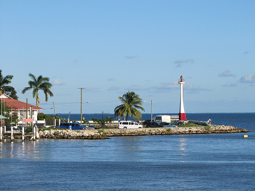
3 Lighthouse Monument/ Baron Bliss Tomb. The Baron Bliss Memorial commemorates the British Baron Henry Edward Ernest Victor Bliss, who, seriously ill, anchored his yacht "Sea King II" off Belize in January 1926 and died on March 9, 1926 without ever setting foot on the ground Belize to have set. Nevertheless, he fell in love with this country so much that he bequeathed his entire fortune to the country and its citizens. Baron Bliss Day was established as a national holiday in his honor. The memorial in which Baron Bliss was buried in 1926 can be found on Fort Street in the Fort George District.
Bliss Institute for Performing Arts
4 Museum of Belize. The
museum presents a good overview of the country's history. This
can be found in the Fort George District on Gabourel Lane. Open:
Mon – Fri 9:00 a.m. – 5:00 p.m.
5 Maritime Museum. The
Maritime Museum uses pictures and models to provide information
about the world heritage “Belize Barrier Reef” and the
associated ecosystem. This can be found on North Front Street
and opens its doors from 8:30 a.m. to 4:30 p.m.
6 Image
Factory, on North Front Street. Open: Mon – Fri 9:00 a.m. – 5:00
p.m., exhibition of work by Belizean artists.
Memorial Park. The park is located between North Park Street and South Perk Street and commemorates the British victory against the Spanish at St. George's Caye.
By plane
1 Philip S. W. Goldson International
Airport, Belize City, ☎ +501 225-2045, e-mail: bacc@pgiabelize.com. (BZE IATA) It is about 30 minutes drive (15 Km) northwest of Belize
City centre in the village of Ladyville. BZE is connected from the
U.S. (American, Delta, United, and Southwest); from Central America
(Avianca El Salvador, Transportes Aéreos Guatemaltecos and Copa) and
from the surrounding regions of Belize, the Yucatan Peninsula and
from Flores by Maya Island Air and Tropic Air. There are seasonal
flights offered from Canada with Air Canada Rouge and Westjet. The
best way to get to and from the city centre is by taxi. If going to
San Ignacio see "By shuttle" in the below as there are shuttle
companies based in San Ignacio that does airport transfers to San
Ignacio and to the surrounding areas in the Cayo District. Some may
connect the airport to other places such as the water taxi terminals
in Belize City or Placencia from the airport without going to San
Ignacio. Ask. An airport bus service does exist, but it is very
infrequent and unreliable.
2 Sir Barry Bowen Municipal
Airport (TZA IATA). Flights to/from regional airports Sir Barry
Bowen Municipal Airport.
By water taxis
3 Ocean Ferry
Belize, 50 N Front St (Along Front Street at the northeast end of
the Swing Bridge), ☎ +501 223-0033, +501 233-0033, +501 223-2033.
Connects Belize City to Caye Chapel, Caye Caulker and San Pedro.
4 San Pedro Express (http://www.belizewatertaxi.com), 111 N Front St
(behind a marketplace located 250 m east along Front St from the
Swing Bridge & the Ocean Ferry Belize Terminal.), ☎ +501 223-2225.
Connects Belize City to Caye Caulker and San Pedro Town. They have a
once daily connection from Caye Caulker and from San Pedro to
Chetumal.
There are very good shopping opportunities around
Albert Street.
You can also find typical goods from the various
Belizean cultures at the National Handicraft Center on South Park
Street.
In the Belize Photo Lab on Albert Street you can find
everything related to photography.
Gifts of all kinds can be
found at the Belize Tourist Village on Fort Street.
Belize City is located in the Belize District, at approximately
17°29′N, 88°11′W, where the Belize River meets the Caribbean Sea. It
occupies a low-lying coastal plain, much of it reclaimed from mangrove
swamps, with Haulover Creek (a river distributary) splitting the city
into northern and southern halves. The city spans about 14 square miles,
with suburbs like Ladyville and Burrell Boom extending its reach.
Key geographical features include:
Coastal Setting: Built on
reclaimed land and mangrove islands, the city sits at sea level, making
it vulnerable to hurricanes and flooding. Breakwaters and seawalls
protect the shoreline, but storms like Hurricane Hattie (1961) have
shaped its history.
Haulover Creek: Divides the city, with the iconic
Swing Bridge—one of the world’s last manually operated swing
bridges—connecting the north (Fort George) and south (downtown) sides.
The creek supports small boats and adds a scenic element.
Mangrove
Wetlands: Surround the city, hosting crabs, manatees, and birds like
herons and frigatebirds. Nearby wetlands, part of the Belize Barrier
Reef ecosystem (UNESCO World Heritage Site, 10–30 miles offshore), are
biodiversity hotspots.
Tropical Climate: Temperatures range from
75–90°F, with high humidity. The dry season (February–May) is pleasant,
while the wet season (June–November) brings heavy rains and hurricane
risks (August–October peak).
The city’s flat terrain and coastal
vibe, with breezes carrying salt air, create a distinct atmosphere,
though urban sprawl and drainage issues can lead to flooding in low
areas.
Belize City’s history is a tapestry of indigenous roots, colonial
struggles, and modern independence:
Pre-Columbian Era: The area
was home to Maya communities, with fishing and trade along the Belize
River. Nearby Altun Ha, 30 miles north, was a major Maya center (200
BC–AD 900).
Colonial Period (1600s–1800s): Founded in the mid-17th
century by British buccaneers and loggers, the settlement grew around
the river’s mouth, harvesting logwood and mahogany. Known as “Belize
Town,” it became a hub for the Baymen (British settlers) and enslaved
Africans, who cut timber under harsh conditions. The 1798 Battle of St.
George’s Caye, fought offshore, secured British dominance over Spanish
claims, cementing Creole culture.
19th Century: As the capital of
British Honduras, Belize City thrived as a port, with wooden mansions
built by timber barons. The Swing Bridge (1923) and St. John’s Cathedral
(1812) date to this era. Storms, like the 1931 hurricane, repeatedly
battered the city, killing thousands.
20th Century: Hurricane Hattie
(1961) devastated Belize City, killing 400 and prompting the capital’s
move to Belmopan, a safer inland site. The city rebuilt, but economic
focus shifted to tourism and trade. Independence in 1981 solidified its
cultural role, with Creole and Garifuna influences shaping festivals and
cuisine.
Modern Era: Today, Belize City is a commercial hub, hosting
banks, shipping firms, and the Philip S.W. Goldson International Airport
(15 miles northwest in Ladyville). Urban challenges—poverty, crime,
infrastructure strain—persist, but revitalization efforts, like
waterfront upgrades, aim to boost appeal.
Belize City is Belize’s cultural heartbeat, reflecting a melting pot
of ethnicities and traditions:
Creole Dominance: About 50% of
residents are Creole (African-European descent), shaping the city’s
Kriol language (a lilting English-based dialect), music (brukdown, punta
rock), and food (rice and beans, stewed chicken, fry jacks). Kriol
phrases like “Weh di go aan?” (What’s happening?) echo in markets.
Multicultural Mix: Maya (Yucatec, Mopan), Garifuna (Afro-Indigenous),
Mestizo (Spanish-Maya), East Indian, Chinese, and Mennonite communities
add diversity. Garifuna drumming and Maya cacao rituals coexist with
East Indian curries and Chinese noodle shops.
Festivals: September
Celebrations mark Independence Day (September 21) and the Battle of St.
George’s Caye (September 10), with parades, soca music, and street food.
Garifuna Settlement Day (November 19) features drumming and jonkonu
dancing. Easter and Christmas bring church fairs and regattas.
Language: English, the official language, ensures easy communication,
but Kriol dominates casual talk, with Spanish and Garifuna heard in
neighborhoods like Queen’s Square.
Religion: Christianity prevails
(Anglican, Catholic, Pentecostal), with St. John’s Cathedral as a
landmark. Small Hindu and Muslim communities reflect East Indian and
Middle Eastern influences.
The city’s culture thrives in its markets,
music venues, and communal spirit, where strangers swap stories over
conch fritters, though urban grit—visible in rundown areas—grounds its
charm in reality.
Belize City’s compact grid is split by Haulover Creek, with distinct
areas:
Fort George (North Side): The historic and upscale district,
home to colonial-era homes, the Baron Bliss Lighthouse, and luxury
hotels like the Radisson. The Tourism Village caters to cruise
passengers, with shops and eateries. Quiet and safer, it’s ideal for
strolls.
Downtown (South Side): The bustling commercial core,
centered on Albert and Regent Streets. Here, you’ll find the Swing
Bridge, Battlefield Park, banks, and markets like Michael Finnegan
Market. It’s vibrant but can feel chaotic, with safety concerns at
night.
Queen’s Square: A Creole and Garifuna hub, known for lively
bars, street vendors selling panades, and community events. It’s
culturally rich but rougher, requiring caution.
King’s Park: A
middle-class residential area with modern homes, schools, and the
Princess Hotel & Casino, blending urban and suburban vibes.
Belama
and Buttonwood Bay: Newer suburbs with gated communities and expat
homes, quieter but less characterful.
Southside Ghettos (e.g., Lake
Independence): Poorer areas with gang activity, best avoided by visitors
unless with a trusted guide for cultural tours.
The city’s wooden
architecture—elevated clapboard houses painted in pastels—gives it a
Caribbean feel, though concrete buildings and traffic jams mark
modernization.
Belize City drives Belize’s economy, handling 60% of the country’s
trade through its port. Key sectors include:
Tourism: Cruise ships
dock at Fort George, bringing 1 million visitors annually (pre-COVID
figures). Hotels, from budget guesthouses to the Best Western Biltmore,
cater to all.
Commerce: Banks (Belize Bank, Scotiabank),
supermarkets, and shipping firms cluster downtown. The port exports
sugar, bananas, and seafood.
Education and Health: The University of
Belize and Karl Heusner Memorial Hospital are here, serving the nation.
Challenges: Poverty affects 30% of residents, with gang violence in
southside areas like Lake Independence. Crime rates (homicides down to
80–100 annually by 2023) are high for Belize’s size, though tourist
zones are safer with police patrols.
Revitalization projects, like
waterfront boardwalks and the 2022 cruise terminal expansion, aim to
boost tourism, but infrastructure—potholed roads, aging drainage—lags.
Belize’s GDP (~$3 billion USD) relies on the city, with tourism and
agriculture leading.
Belize City is a dynamic stopover, best for 1–2 days before heading
to cayes or jungles. Key details:
Access: Philip S.W. Goldson
International Airport (BZE) is 15 miles northwest, with taxis (~$25 USD)
or shuttles to downtown. Water taxis to Caye Caulker depart from the
Marine Terminal. Buses connect to Belmopan (1 hour, $5 USD) and Orange
Walk (1.5 hours).
Accommodation:
Luxury: Radisson Fort George
(~$150–200 USD/night) offers sea views and pools.
Mid-range: D’Nest
Inn ($80 USD) or Best Western ($100 USD) balance comfort and cost.
Budget: Bella Vista Guesthouse (~$30 USD) suits backpackers.
Dining:
Riverside Tavern: Upscale Creole fare (conch ceviche,
burgers, ~$15 USD).
Celebrity Restaurant: Local vibe with stewed pork
and rum popo (milkshake, ~$10 USD).
Street Food: Try garnaches or
salbutes near Battlefield Park (~$1–2 USD).
Activities: Walking tours
($30 USD) cover Fort George and downtown, hitting the cathedral and
museum. River cruises ($50 USD) or day trips to Altun Ha (~$80 USD) are
popular. Nightlife thrives at bars like Thirsty Thursday or the Princess
Casino.
Safety: Stick to Fort George and downtown by day, avoiding
southside areas like Collet after dark. Petty theft (pickpocketing) is
the main risk; use hotel safes and travel in groups at night. Police
presence is strong in tourist zones.
Vibe: Visitors praise the city’s
“raw energy,” per TripAdvisor, with colorful houses and Kriol banter
creating a Caribbean feel. Some find it “shabby,” citing litter or stray
dogs, but cultural gems—live punta music, fresh conch—win over most.
Belize City shapes Belize’s identity, hosting events like the Belize
International Film Festival and fostering artists like Supa G (punta
rock). Community programs, like the YMCA’s youth outreach, counter gang
influence, while churches and NGOs aid education and health. Tourism
employs thousands, from guides to vendors, though cruise crowds can
overwhelm downtown, prompting calls for sustainable visitor caps.
The city’s diversity shines in its food (Garifuna hudut, Maya
tamales), music (Creole brukdown, Garifuna wanaragua), and markets,
where Mennonite farmers sell cheese beside Maya herbalists. Its
challenges—poverty, crime—reflect Belize’s broader struggles, but
resilience defines its spirit.
Cost: Budget travelers spend $50–100 USD/day (hostels, street food),
mid-range $150–250 USD (hotels, tours), luxury $300+ USD. Museums cost
$5–10 USD; meals range from $2 USD (street) to $20 USD (restaurants).
Preparation: Pack light clothing, rain gear (wet season), and sturdy
shoes for uneven sidewalks. Bring cash (BZD, USD accepted) for markets;
ATMs are plentiful. Mosquito repellent is a must.
Safety: Avoid
flashing valuables; use licensed taxis (green plates). Stay north of the
creek at night. Emergency numbers: police 911, hospital 223-1548.
Cultural Respect: Greet with a smile (“Mawnin!”); ask before
photographing people. Tip 10% at restaurants if not included. Respect
Garifuna or Maya ceremonies if invited.
Best Time: February–April for
dry weather and festivals. Avoid September–October for hurricane risks,
though crowds are thinner.
Getting Around: Walk downtown (compact,
1–2 miles across). Taxis cost $5–10 USD within city limits. Bikes (~$10
USD/day) suit Fort George. Buses and water taxis link to suburbs and
cayes.