Location: 12 mi (19 km) North- West of San Ignacio, Cayo District Map
El Pilar is a significant yet understudied ancient Maya archaeological site located in the Cayo District of western Belize, near the border with Guatemala. Straddling both countries, with its main section in Belize, El Pilar is situated approximately 12 miles northwest of San Ignacio and 6 miles north of Bullet Tree Falls, within the Upper Belize River Valley. Covering about 120 acres and encompassing over 25 plazas, hundreds of structures, and a population estimated at 18,000–20,000 at its peak, El Pilar was a major civic-ceremonial center during the Classic Period (250–900 CE). Its name, meaning “water basin” or “watering hole” in Spanish, reflects the abundance of springs and water sources in the area, a critical factor in its development. Unlike heavily restored Maya sites like Tikal or Caracol, El Pilar is preserved in a “conservation archaeology” model, with most structures left unrestored and covered by jungle canopy, offering a unique glimpse into Maya urban planning and sustainable land use.
El Pilar thrived as a major Maya center from the
Middle Preclassic Period (ca. 800 BCE) through the Late Classic Period
(ca. 900 CE), with evidence of occupation extending into the Early
Postclassic (ca. 1000 CE). Its strategic location on an escarpment 900
feet above sea level, overlooking the Belize River Valley, provided
natural defenses and access to fertile agricultural lands, aguadas
(natural reservoirs), and trade routes connecting the Petén region of
Guatemala, the Caribbean coast, and other Maya centers like Tikal (40
miles southwest) and Caracol (30 miles south). The site’s proximity to
the Mopan and Macal Rivers, tributaries of the Belize River, facilitated
trade and communication.
El Pilar was a complex urban center with
a sophisticated social, political, and economic structure. Its residents
included elites, artisans, farmers, and laborers, supported by a mixed
economy of agriculture, trade, and resource management. The site’s
layout reflects the Maya’s deep understanding of their environment, with
residential areas, civic-ceremonial complexes, and agricultural terraces
integrated into the landscape. El Pilar’s longevity and resilience are
notable, as it maintained stability during the Classic Maya collapse
(ca. 800–900 CE), when many other centers declined, possibly due to its
sustainable land-use practices and water management systems.
Culturally, El Pilar was a hub of Maya ritual and governance. Its
temples, palaces, and ballcourts indicate a society with complex
religious practices, political hierarchies, and social interactions. The
site’s causeways and plazas suggest it hosted large gatherings, markets,
and ceremonies, reinforcing its role as a regional capital. Artifacts
like ceramics, obsidian, and jade point to extensive trade networks,
while the presence of elite residences and burials underscores social
stratification.
El Pilar’s archaeological record, primarily studied
through surveys and limited excavations, reveals a long occupational
history. The site comprises two main sectors—Greater El Pilar in Belize
and a smaller western section in Guatemala—connected by causeways. Its
core includes over 25 plazas, 15 courtyards, 70 major structures, and
hundreds of smaller buildings, with an estimated 700–1,000 structures
overall. The site’s chronology is divided into the following phases:
Preclassic Period (800 BCE–250 CE)
Middle Preclassic (800–400
BCE): The earliest evidence of settlement at El Pilar dates to this
period, with small agricultural communities establishing themselves on
the escarpment. Simple structures and ceramics, such as those of the
Cunil phase, indicate early Maya cultural development.
Late
Preclassic (400 BCE–250 CE): Population growth led to the construction
of larger structures, including early pyramids and plazas. The site
began to take shape as a regional center, with evidence of terracing and
water management systems to support agriculture.
Classic Period
(250–900 CE)
Early Classic (250–600 CE): El Pilar grew into a major
urban center, with monumental architecture like pyramids, temples, and
palaces. The construction of causeways, such as the 500-meter-long
Causeway A, connected plazas and facilitated movement. Elite residences
and burials with offerings (jade, ceramics, obsidian) reflect increasing
social complexity.
Late Classic (600–900 CE): This was El Pilar’s
peak, with a population of 18,000–20,000 and extensive urban
development. Major structures like Plaza Copal and the H’Mena acropolis
were expanded, and the site’s 25 plazas were fully developed.
Agricultural terraces, check dams, and aguadas supported a dense
population. Stelae and altars, though fewer than at Tikal, indicate
political and ritual activity. El Pilar’s stability during the Terminal
Classic (800–900 CE), when many Maya centers collapsed, suggests
adaptive resource management.
Postclassic Period (900–1000 CE)
Early Postclassic (900–1000 CE): El Pilar experienced a gradual decline
but remained occupied, unlike many Classic centers. Reduced construction
and fewer elite artifacts suggest a smaller population, possibly due to
environmental or political pressures. By 1000 CE, the site was largely
abandoned, though some areas may have been used sporadically.
Post-Abandonment
After 1000 CE, El Pilar was reclaimed by the jungle,
preserving its structures under a protective canopy. Minimal
post-abandonment looting, compared to sites like Tikal, has left much of
the site intact, though modern agricultural activity and illegal logging
pose threats.
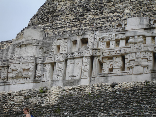
El Pilar’s layout is characterized by a blend of
civic-ceremonial and residential zones, connected by causeways and
integrated with the natural landscape. Key features include:
Plaza Copal: The main ceremonial plaza, surrounded by large pyramids and
temples, likely used for public rituals and elite activities. Its
central location and monumental architecture mark it as the heart of El
Pilar’s civic core.
H’Mena Acropolis: A sprawling elite residential
and administrative complex, featuring palaces, courtyards, and
restricted-access areas. Its elevated position and intricate design
suggest it housed rulers and their families.
Tzunu’un Complex: A
well-preserved residential compound, partially excavated to reveal a
typical Maya household. It includes a kitchen, living quarters, and a
small shrine, offering insights into daily life. Tzunu’un is a focal
point for visitors, showcasing the “archaeology under the canopy”
approach.
Causeways: Several causeways, including Causeway A (500
meters long), link plazas and residential areas, facilitating movement
and trade. These raised limestone paths reflect advanced urban planning.
Ballcourt: A standard Maya feature, the ballcourt at El Pilar was used
for the ritual ballgame, a socially and politically significant
activity. Its presence underscores the site’s cultural alignment with
other Maya centers.
Agricultural Terraces and Aguadas: Extensive
terracing on the escarpment supported intensive agriculture, while
aguadas and check dams managed water for drinking and irrigation. These
features highlight El Pilar’s sustainable land-use practices.
Lucha
and Leon Complexes: Smaller residential and ritual areas, these
complexes include temples and platforms, indicating a mix of domestic
and ceremonial functions.
Artifacts at El Pilar include ceramics
(e.g., polychrome vases, utilitarian wares), obsidian tools, jade
ornaments, and chert implements, reflecting both local production and
trade. The absence of many stelae and hieroglyphic inscriptions,
compared to Tikal or Copán, suggests El Pilar’s rulers may have
expressed power through architecture and urban planning rather than
monumental texts.
El Pilar offers critical insights into Maya urbanism,
environmental adaptation, and social organization. Its extensive
residential zones, covering 70% of the site, reveal a dense urban
population supported by sophisticated agriculture and water management.
The site’s integration with the landscape—using natural ridges, springs,
and terraces—demonstrates the Maya’s ecological knowledge, challenging
narratives of environmental mismanagement as a cause of the Classic
collapse.
Politically, El Pilar was likely a regional capital,
possibly allied or in competition with nearby centers like Xunantunich,
Baking Pot, or Tikal. Its causeways and plazas suggest a centralized
authority capable of mobilizing labor and resources. The presence of
elite residences and ritual spaces indicates a stratified society, with
rulers, priests, and artisans playing key roles.
El Pilar’s
survival into the Terminal Classic and Early Postclassic periods
highlights its resilience. Unlike Tikal, which saw significant decline,
El Pilar’s water-rich environment and agricultural systems may have
buffered it against drought or political instability. The site’s
abandonment by 1000 CE remains poorly understood but may reflect
regional depopulation or shifts in trade routes.
Culturally, El
Pilar bridges the Preclassic and Classic Maya worlds, with continuity in
ceramic styles and architectural forms. Its ballcourt and temples align
with broader Maya religious practices, including worship of deities like
the rain god Chaac and rituals tied to agriculture and cosmology.
El Pilar is managed as an archaeological reserve by
Belize’s National Institute of Culture and History (NICH) and is part of
the El Pilar Forest Reserve for Maya Flora and Fauna, established in
1998. The site’s conservation approach, pioneered by archaeologist
Anabel Ford, emphasizes minimal intervention, leaving structures
unexcavated and covered by jungle to protect them from weathering and
looting. This “archaeology under the canopy” model contrasts with
heavily restored sites like Chichén Itzá, offering a more authentic,
immersive experience.
Access and Logistics:
Location: El Pilar
is accessed via a 7-mile dirt road from Bullet Tree Falls, passable by
4WD vehicles or taxis. The road can be rough during the rainy season
(June–November), so visitors should check conditions.
Hours and Fees:
The site is open daily from 8 AM to 5 PM. The entry fee is approximately
BZD $10 for non-Belizeans and BZD $5 for Belizeans, with free entry for
Belizeans on Sundays and holidays.
Facilities: Basic amenities
include a visitor center, restrooms, and picnic areas. There is no
on-site museum, but interpretive signs and trails guide exploration.
Guides are recommended and can be arranged through the El Pilar
Archaeological Reserve or local tour operators in San Ignacio.
Trails: Several trails, such as the Maya Forest Garden Trail and the
Tzunu’un Trail, allow visitors to explore plazas, residences, and
natural features. The trails highlight the site’s integration with the
forest, including medicinal plants and wildlife (e.g., howler monkeys,
toucans).
Visitor Experience:
El Pilar attracts fewer tourists
than popular sites like Xunantunich or Caracol, offering a tranquil,
nature-immersed experience. Visitors can climb partially exposed
structures like those in Plaza Copal and explore the Tzunu’un household,
which provides a tangible connection to Maya daily life. The jungle
setting, with its dense canopy and wildlife, enhances the sense of
discovery, though some find the lack of restored buildings less visually
striking. Reviews praise the site’s peaceful ambiance and knowledgeable
guides but note the challenging road access and limited signage. A visit
typically takes 2–3 hours, with additional time for hiking or
birdwatching.
Community Involvement:
The site engages local
Mopan Maya communities, particularly from Bullet Tree Falls and Santa
Familia, through the El Pilar Forest Gardening Initiative. This program
promotes traditional Maya agricultural practices, such as milpa farming
and forest gardening, fostering cultural continuity and sustainable
tourism. Community members serve as guides and caretakers, ensuring
local benefits from tourism.
El Pilar was first documented in 1972 by Belize’s
Department of Archaeology, but systematic research began in 1983 under
Anabel Ford of the University of California, Santa Barbara. Ford’s
BRASS/El Pilar Program (Belize River Archaeological Settlement Survey)
mapped the site using GPS and conducted limited excavations, focusing on
residential areas and land-use patterns. Her work revealed El Pilar’s
urban density and agricultural sophistication, challenging assumptions
about Maya dependence on slash-and-burn farming.
Preservation
efforts prioritize ecological and cultural sustainability. The jungle
canopy protects structures from erosion and looting, while the El Pilar
Forest Reserve safeguards 2,000 acres of surrounding habitat. Threats
include illegal logging, agricultural encroachment, and border disputes
between Belize and Guatemala, as the western section lies in a contested
zone. The 1997 establishment of the reserve and binational cooperation
aim to mitigate these issues.
Ford’s advocacy for “archaeology
under the canopy” has made El Pilar a model for conservation
archaeology, balancing research, tourism, and environmental protection.
The site’s designation as a UNESCO World Heritage tentative list
candidate underscores its global significance.